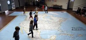
 National Geographic is bringing a gigantic map of North America to Tuckahoe Elementary, part of an effort to get students more engaged with geography studies.
The map, measuring 26 feet by 35 feet and weighing in at 102 lbs., is one of the world’s largest maps of the continent. It will be on display from Nov. 29 to Dec. 10.
Students will be able to walk on the map, play interactive games and explore various geographic features.
“This is a unique and interactive opportunity to introduce and reinforce the geographic features of our great country with hands-on and feet-on instruction,” Tuckahoe principal Cynthia Brown said in a statement.
Screen capture via YouTube

