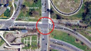
 (Updated at 10:25 a.m.) A week after another cyclist was hit at the intersection of Lee Highway, N. Lynn Street at the Custis Trail, the Arlington County Board approved adding $75,000 to a contract to engineer improvements to the intersection.
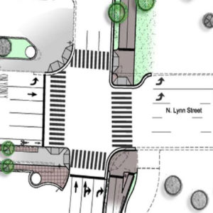
The planned improvements to the area, which includes the trail’s intersection with Fort Myer Drive, include removing a travel lane from Lee Highway and extending the curb at the intersection’s corners. It also calls for upgraded traffic signals, on-street bike lanes, signs and landscape areas and a “Corridor of Light” public art feature.
The most troublesome part of the intersection. where numerous car-on-bike accidents have occurred, has been where two lanes of traffic from I-66 turn right on N. Lynn Street toward the Key Bridge. That traffic comes in conflict with pedestrians and cyclists on the trail, who get the green light at about the same time.
The improvements are designed to give cyclists less time in traffic as a result of the extended curbs, as well as greater visibility and a safer “queueing” area. In addition, the start of the Custis Trail would be widened to allow for greater cyclist and pedestrian flow.
The Board voted yesterday to amend its contract with Toole Design Group, which is designing the updates to the intersection, to include additional design of underground features and water main relocation. The project is expected to be 90 percent complete with design by this summer with construction beginning next spring and completing by summer 2016.
Once the project reaches 90 percent design, Arlington Department of Environmental Services says it will schedule a public meeting to present the intersection’s final design to the community.
 According to DES, the design of the improvements were funded by a federal grant, and the construction is being paid for by the JBG Companies, which is developing the Central Place office and residential skyscrapers two blocks away. If approved, the contract amendment will bring the total cost of the design to almost $1.2 million. The construction is currently estimated to cost $5 million.
The intersection was cited as needing a redesign in the Realize Rosslyn public outreach process, and some have suggested a pedestrian tunnel or flyover. According to DES, there are no other plans for improvements to this intersection, but the construction doesn’t preclude any changes in the future.
“There’s been a lot of attention at ways we can improve this intersection,” County Board Chair Jay Fisette said at yesterday’s meeting. “The Realize Rosslyn process is underway, and we did [talk about] incorporating some focus into potentially systemic changes to the intersection.”
In addition to the trail improvements, Arlington announced yesterday it purchased a plot of land adjacent to the intersection, at 1101 Lee Highway, to preserve green and recreational space for the area. The land might also some day be used for a realignment of the bike trail, to improve safety.
The county paid $2.4 million to a private landowner and is considering constructing an “ancillary boathouse” to pair with a proposed boathouse along the Potomac River that the National Parks Service is considering.
“Over the years, community members have voiced strong support for a boathouse in the County along the Potomac River,” the county wrote in its press release, “to create public access, establish a home for high school rowing programs and to offer educational opportunities related to life along the Potomac.”

