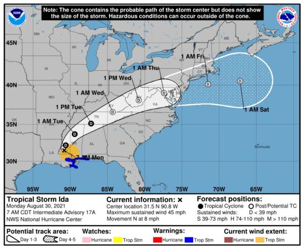
(Updated at noon) The remnants of Hurricane Ida are heading our way, and forecasters are already warning of potential flooding.
Ida has ravaged portions of Louisiana and Mississippi since making landfall as a Category 4 storm Sunday afternoon. It knocked out power to more than a million homes and businesses, including the entire city of New Orleans; interrupted 911 service; and caused catastrophic flooding, prompting numerous water rescues.
Now a tropical storm, Ida is on a northeasterly track that is expected to put its remnants squarely over the D.C. area starting Wednesday.
Two days ahead of Ida’s arrival, the National Weather Service this morning issued a Flash Flood Watch, to take effect from 11 a.m. Wednesday to 8 a.m. Thursday. Some 2-5 inches of rain could fall during that time.
Forecasters are also warning of the potential for severe weather or even tornadoes spawned by Ida.
“Heavy tropical rainfall could result in considerable flash flooding,” NWS wrote. “A few severe thunderstorms are possible Wednesday into Wednesday night. Damaging wind gusts and a brief tornado are the main threats.”
More from NWS:
…FLASH FLOOD WATCH IN EFFECT FROM WEDNESDAY MORNING THROUGH THURSDAY MORNING…
The National Weather Service in Sterling Virginia has issued a
* Flash Flood Watch for portions of DC, Maryland and Virginia…
* From Wednesday morning through Thursday morning.
* The remnants of Ida will interact with a stalled front, resulting in a prolonged period of heavy rainfall beginning Wednesday morning and continuing through Wednesday night. Rainfall amounts of 2 to 4 inches are expected, with localized amounts up to 6 inches possible.
* This amount of heavy rainfall will not only result in the potential for considerable flash flooding of creeks, small streams, and urban areas, but also the potential for river flooding on the main stem rivers.
PRECAUTIONARY/PREPAREDNESS ACTIONS…
You should monitor later forecasts and be prepared to take action should Flash Flood Warnings be issued.
Strong storms are also possible tonight (Monday), with the arrival of a cold front that will end our stretch of sweltering weather and temperatures in the 90s.
“Isolated damaging wind gusts are possible this afternoon and evening,” NWS wrote. “An isolated instance of flooding is also possible.”
Just before noon, a Flash Flood Watch was issued for Monday afternoon.
1148 AM EDT Mon Aug 30 2021
…FLASH FLOOD WATCH IN EFFECT UNTIL 10 PM EDT THIS EVENING…
…FLASH FLOOD WATCH REMAINS IN EFFECT FROM WEDNESDAY MORNING
THROUGH THURSDAY MORNING…The National Weather Service in Sterling Virginia has issued a
* Flash Flood Watch for portions of DC, Maryland and Virginia…
* Until 10 PM EDT this evening.
* Scattered to numerous showers and thunderstorms are likely this afternoon and evening, some of which may produce a few inches of rain in a short period of time.
* Heavy rainfall in a short period of time would result in rapid rises of water in small streams and creeks, and in urban and poor drainage areas.
PRECAUTIONARY/PREPAREDNESS ACTIONS…
You should monitor later forecasts and be prepared to take action should Flash Flood Warnings be issued.
A Flash Flood Watch is in effect from 2pm this afternoon through 10pm this evening. Showers and strong thunderstorms will develop and push eastward across the region. Aside from gusty winds and hail, this activity will bring heavy downpours which could lead to flash flooding. pic.twitter.com/LvK8ySuDtp
— NWS Baltimore-Washington (@NWS_BaltWash) August 30, 2021

