Nearly 30 years in the making, the Army Navy Country Club Trail Connector is closer to becoming a reality.
Construction on the long-proposed trail, a design for which has not yet been finalized, is expected to begin in spring 2024, officials say. Work could be completed the following spring, according to a recent county presentation.
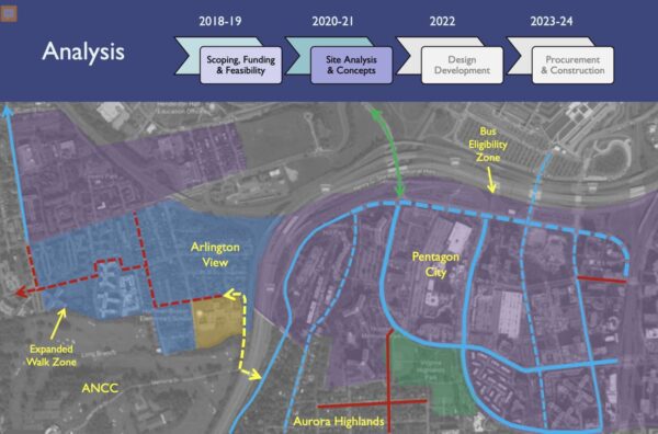
The path for cyclists and pedestrians would run from a point near Hoffman-Boston Elementary and 13th Road S., in the Arlington View neighborhood, to Army Navy Drive near the I-395 overpass and the entrance to the club. It would provide a new way to get from Columbia Pike to Pentagon City.
The county is seeking community feedback on two preliminary concepts for the trail, which can be provided through the project’s website.
Final design will be completed in spring 2023, then there will be another opportunity for public feedback. By winter 2023, a contract should be awarded and an official construction timeline will be released, Project Manager Mark Dennis said.
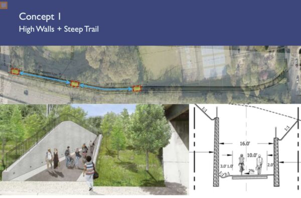
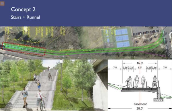
Two preliminary concepts are being considered. One features high walls and a steep trail, which could cost $11 million. The other is defined by stairs and a runnel, and could cost $5 million.

This first concept includes a 10-foot-wide, multi-use trail with a steep, 12% slope centered between retaining walls. The walls would run approximately 16 feet apart, and could be up to 16 feet in height.
Further design of Concept 1 would have to address the transition at Memorial Drive — the connector road leading to the club — where cyclists would have limited visibility to react to vehicular traffic.
Dennis compared the high walls and steep trail concept to the Custis Trail, which also has a 12% slope in some sections, he said.
“Any users out there who have taken the Custis Trail, you know what this feels like, it’s a great workout for those who are up to it,” he said. “It can be a little bit of a challenge for people who are just out for a simple walk or just want to get from A to B and not have such a vigorous bike ride.”
The second concept is a series of stairs and landings to manage the steep slope, and would feature a runnel, or wheel channel, for bicycles that could also accommodate strollers or carts.

Several people raised concerns about accessibility for both concepts. Neither design features a winding, gradual slope, but the county has to work with what it’s got, Dennis said.
“The country club has very carefully considered our previous requests to expand the easement to grant more easement and they have respectfully declined,” Dennis said. “We are limited by the easement that we have and we have sufficient easement to accommodate concepts like the two I’ve presented.”
Those who have followed the project’s iterations may notice the easement’s shape has changed. After Arlington public safety officials rejected the emergency access road idea that was originally part of the project, the path’s endpoint near Hoffman-Boston shifted from S. Queen Street to the other side of the school, near the tennis and basketball courts, Dennis said.
Dennis said the project won’t be “all things to all people,” but the narrow, steep property will probably draw a “sort of self-selecting group of users,” he said.
“We hope it’ll be accessible for anyone who can climb stairs, we hope to be accessible for anyone who rides most kinds of bikes,” he said. “But we’re going to look at that very carefully in design and try our best to accommodate the broadest range of potential users.”
The project has been discussed since the early 90s and overcome many hurdles, including obtaining an easement from the country club, a resulting lawsuit from club members, the elimination of the emergency service road, and delays due to funding constraints.

