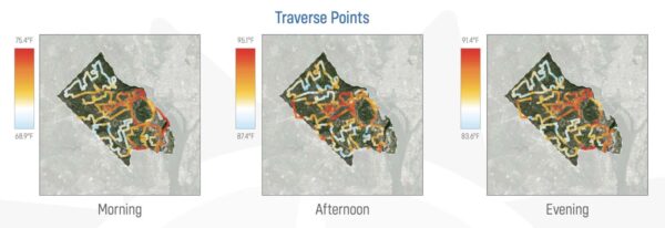
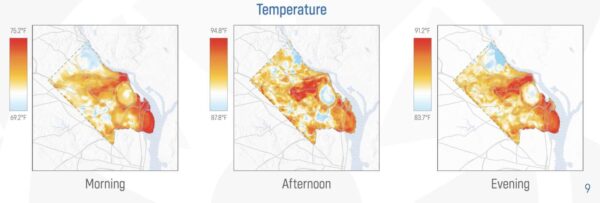
The most scorching parts of Arlington are along the Rosslyn-Ballston corridor and Reagan National Airport, according to a new study.
On a hot day last July, volunteers and Marymount University research students and staff recorded temperatures at morning, afternoon and evening throughout the county as part of the Virginia Foundation for Independent Colleges’ Heat Watch Campaign. Residents across the Commonwealth also contributed to the statewide data collection effort.
That data has since been compiled into heat maps, released this week, that cover more than 300 square miles of Virginia. Environmentalists say this information is helpful for targeting solutions to heat: planting more trees where possible and, where that is not possible, adding amenities like community gardens and planted walls.
Although Arlington County is compact, temperatures varied by up to 7 degrees depending on location. The Rosslyn-Ballston corridor, for example, recorded a temperature of 94.8 degrees at 3 p.m., and less than two miles away, neighborhoods near the Potomac Overlook Regional Park clocked in at 87.8 degrees.

Marymount University assistant biology professor Susan Agolini says highly populated areas like Ballston and Clarendon are often hotter because concrete and asphalt absorb heat and radiate it back into the environment, while the North Arlington neighborhoods closest to the Potomac River have trees and gardens to soak up that sunshine.
“I do not think there were any surprises here with regard to what areas were hotter,” Agolini said. “We know that locations with a lot of pavement and cement are going to be hotter than areas with a lot of trees and green space. The question is what do we do about that?”
Agolini says she will bring this data to conversations with county officials about urban planning and cooling solutions, such as planting trees and incentivizing the creation of community gardens around buildings and on their rooftops.
For example, 23% of the Ballston-Virginia Square Civic Association had tree canopy compared to 74% of the Bellevue Forest Civic Association, according to the most recent county tree canopy data, from 2016.

“I find it really compelling that the benefits of and need for increased space for urban agriculture could actually serve multiple purposes,” Agolini said. “It would not only provide Arlington residents with the physical and mental health benefits of growing their own food, but it could also have the added benefit of decreasing the impact of heat disparities throughout the county.”
Elenor Hodges — the executive director of the community organization promoting environmental stewardship, EcoAction Arlington — helped collect temperature data last summer. She says the data provide “another way of looking at a known issue.”
And the solution — more trees and plantings — has benefits that bleed into other environmental and public health goals, she said.
“If you’re building in an area and you can think about having it be as green and plant-based green as possible then that makes the space cooler,” she said. “You can be happier in this space, healthier, and it helps with carbon and it reduces stormwater runoff.”
Hodges said EcoAction Arlington would like to see this data inform developments currently going through the county review processes so that the projects can reduce, rather than contribute to, Arlington’s heat zones.
This includes planting walls of plants, blending indoor and outdoor spaces, and adding trees and plantings to grass-covered parks, as grass doesn’t absorb as much heat.
The organization, which oversees a county program that plants trees on private property through developer contributions, will be launching a campaign to encourage planting in neighborhoods with less tree canopy that also have higher rates of poverty and substantial non-white populations.
For example, tree canopy levels are under 30% in the Arlington View, Buckingham and Green Valley neighborhoods, she said.
“Those are neighborhoods we are going to be looking at more carefully,” Hodges said.


