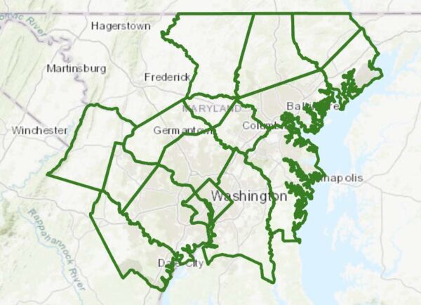
Update at 1:50 p.m. — A Severe Thunderstorm Watch was just issued for parts of the D.C. area, including Arlington, and much of the D.C.-Baltimore-Philly-NYC corridor. That’s in addition to the Flood Watch, below.
From the National Weather Service:
Scattered severe thunderstorms are possible this afternoon and evening, mainly north of the D.C. metro area. Damaging wind gusts are the primary threat with an isolated tornado also possible.
A severe thunderstorm watch has been issued for parts of CT, DE, DC, MD, NJ, NY, PA, VA, WV until 10 PM EDT pic.twitter.com/eal2Prh0i3
— NWS Severe Tstorm (@NWSSevereTstorm) July 18, 2022
Earlier: It’s the middle of July and the humidity level outside is roughly that of an unventilated bathroom after a half-hour hot shower.
Unsurprisingly, that combination is a recipe for possible downpours — and flooding — tonight.
The National Weather Service just issued a Flood Watch, which will go into effect at 4 p.m. Forecasters say “multiple rounds of storms” could cause flooding later today.
There is a marginal risk of severe weather this afternoon and evening from @NWSSPC. Damaging winds are the primary threat, though isolated instances of flooding are possible. #DCwx #MDwx #VAwx #WVwx pic.twitter.com/MxVvFeR5NO
— NWS Baltimore-Washington (@NWS_BaltWash) July 18, 2022
More from NWS:
FLOOD WATCH
NATIONAL WEATHER SERVICE BALTIMORE MD/WASHINGTON DC
931 AM EDT MON JUL 18 2022…FLOOD WATCH IN EFFECT FROM 4 PM EDT THIS AFTERNOON THROUGH THIS EVENING…
* WHAT…FLASH FLOODING CAUSED BY EXCESSIVE RAINFALL IS POSSIBLE.
* WHERE…PORTIONS OF DC, MARYLAND AND NORTHERN VIRGINIA […]
* WHEN…FROM 4 PM EDT THIS AFTERNOON THROUGH THIS EVENING.
* IMPACTS…EXCESSIVE RUNOFF MAY RESULT IN FLOODING OF RIVERS, CREEKS, STREAMS, AND OTHER LOW-LYING AND FLOOD-PRONE LOCATIONS.
* ADDITIONAL DETAILS…
– AFTERNOON TO EVENING SHOWERS AND THUNDERSTORMS MAY PRODUCE VERY HEAVY RAINFALL CAPABLE OF FLASH FLOODING. THIS COULD INCLUDE MULTIPLE ROUNDS OF STORMS WHICH WOULD ENHANCE THE FLOOD RISK. RAINFALL RATES MAY REACH 1 TO 2 INCHES PER HOUR, LOCALLY HIGHER IN SPOTS. THE D.C. AND BALTIMORE METROS WILL BE THE MOST SUSCEPTIBLE GIVEN RECENT HEAVY RAINFALL THE PAST COUPLE OF WEEKS.
– HTTP://WWW.WEATHER.GOV/SAFETY/FLOODPRECAUTIONARY/PREPAREDNESS ACTIONS…
YOU SHOULD MONITOR LATER FORECASTS AND BE PREPARED TO TAKE ACTION SHOULD FLASH FLOOD WARNINGS BE ISSUED.

