(Updated at 3 p.m.) A widespread outbreak of severe weather is expected this evening, prompting a Tornado Watch for Arlington and much of the region.
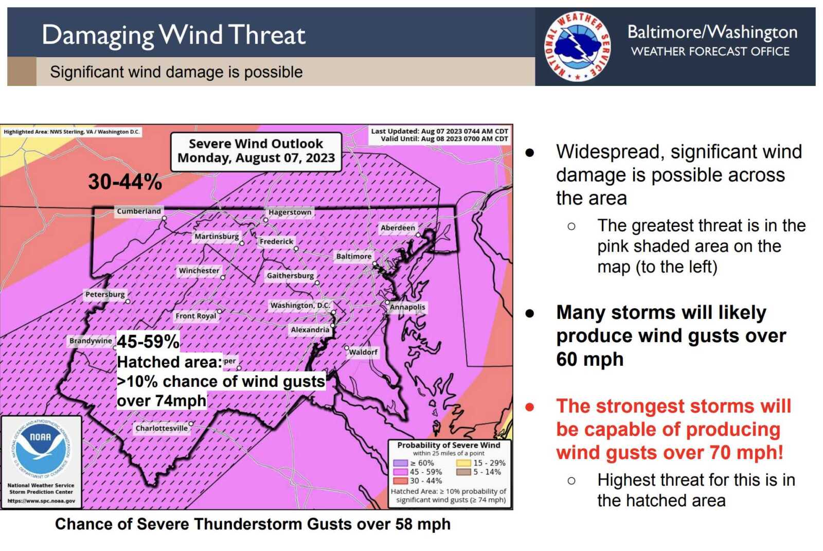
Forecasters say the threats include “damaging and locally destructive hurricane-force winds, along with the potential for large hail and tornadoes, even strong tornadoes.”
Winds in excess of 70 miles per hour are possible.

The Tornado Watch is in effect until 9 p.m.
Arlington Public Schools, meanwhile, is closing facilities early today due to the weather threat. From a School Talk email to families:
Due to forecasted severe weather, Arlington Public Schools will shift to virtual operations today, Aug. 7, at 4 p.m. All APS facilities and programs held after 4 p.m. are canceled unless otherwise stated.
Extracurricular [activities], games, team practices, field trips, adult education classes and programs in schools and on school grounds are canceled this evening. For your safety, we strongly urge the community to stay off the roads between the hours of 4 and 8 p.m.
Federal government and Arlington National Cemetery are also closing early today, at 3 p.m., while Arlington County government offices are closing at 4 p.m.
The expected outbreak follows the storms just over a week ago that toppled trees throughout Arlington and knocked out power to more than 34,000 Dominion customers.
More from the National Weather Service:
…SEVERE WEATHER OUTBREAK EXPECTED OVER THE MID-ATLANTIC REGION BETWEEN 2 PM AND 10 PM TODAY, INCLUDING THE GREATER BALTIMORE/WASHINGTON METROPOLITAN AREAS…
An outbreak of severe storms is expected this afternoon and evening across the greater Baltimore/Washington region, with numerous severe thunderstorms expected. There is a significant threat for damaging and locally destructive hurricane-force winds, along with the potential for large hail and tornadoes, even strong tornadoes.
The timing of this outbreak varies with your location. West of the Blue Ridge Mountains, you can expect the storms to arrive between 12 Noon and 3 PM. East of the Blue Ridge Mountains, timing will be from 4 PM to 8 PM. The greater Baltimore/Washington Metropolitan Areas can expect the storms to arrive between 5 PM and 7 PM.
Now is the time to review your severe weather safety procedures for the possibility of dangerous weather today. Do not be outdoors when the storms arrive. When you hear thunder, go indoors to a sturdy building or structure. While seeking shelter indoors, go to the lowest floor to an interior room. Stay away from windows. Those in mobile homes or weaker structures should plan ahead of time to shelter in a stronger shelter. Be prepared for extended power outages, and the potential for some roads to be blocked by fallen trees.
For the after-event cleanup, do not go outside until 30 minutes after you hear the last thunder, otherwise you will be still susceptible to lightning strikes. Be aware of downed power lines and unstable branches and trees.
Stay tuned to NOAA Weather Radio, weather.gov, or other media for watches and warnings. If a Severe Thunderstorm Warning or Tornado Warning is issued for your area, move to a place of safety, ideally in an interior room on the lowest level of a sturdy building.
A tornado watch has been issued for parts of District of Columbia, Maryland, Pennsylvania, Virginia and West Virginia until 9 PM EDT pic.twitter.com/Z92GYLkeFp
— NWS Tornado (@NWStornado) August 7, 2023
Much of the D.C. area, including Arlington, is under a 4 out of 5 risk of severe weather, a rare designation not seen in the region in more than a decade.
More via social media:
JUST IN: DC area in Level 4 out of 5 risk for severe storms late this afternoon into the evening. This is very rare. We will have more details shortly but it is very important to pay attention to weather details today and have a way to receive storm warnings. pic.twitter.com/msE5zTM7ZH
— Capital Weather Gang (@capitalweather) August 7, 2023
Some perspective: This is the first moderate risk for severe weather in at least 10 years for much of our forecast area.
— NWS Baltimore-Washington (@NWS_BaltWash) August 7, 2023
A severe weather outbreak is expected across parts of the eastern U.S. Monday afternoon & evening with widespread damaging winds, locally destructive & isolated tornadoes and large hail. Greatest threat is across the southern and central Appalachians to the Mid-Atlantic region. pic.twitter.com/mZkPWoSp95
— NWS Eastern Region (@NWSEastern) August 7, 2023
We're getting questions about whether this will be a derecho. We're not sure at this point whether it will meet criteria, but it could have derecho-like impacts in some areas. Be prepared for power outages. https://t.co/Fc2KIApLA7
— Capital Weather Gang (@capitalweather) August 7, 2023
A Tornado Watch will be needed in the coming hour or two for the region as widespread damaging winds gusts and a few tornadoes are expected. The highest tornado threat this afternoon is across the region.
Stay weather-aware today and let others know! #vawx #mdwx #dcwx #wvwx https://t.co/RDeuuYG88k
— Washingtonian Weather Geeks (@WashingtonianWx) August 7, 2023
🪑 Secure patio/balcony/yard items so they don’t blow away
🧹 Remove debris from gutters and drains
🔋 Charge electronics
ℹ️ More tips to prepare for a storm: https://t.co/QNsA7ZQRrB— Arlington County (@ArlingtonVA) August 7, 2023
Flickr pool photo by John Sonderman

