(Updated at 4:20 p.m.) Enjoy the dry weather while it lasts — Saturday is set to be exceptionally wet and windy.
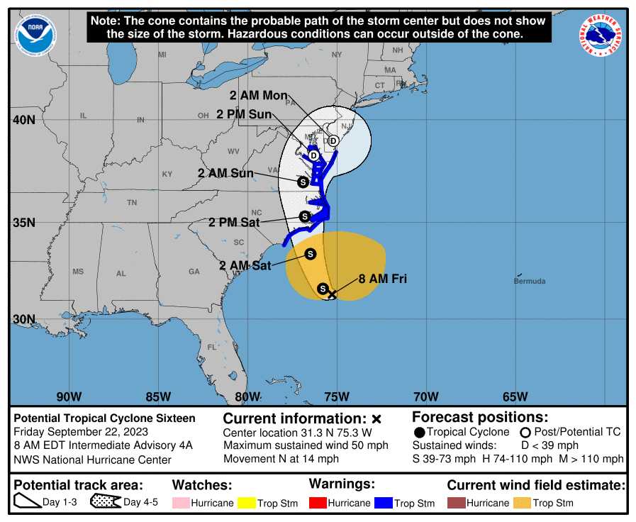
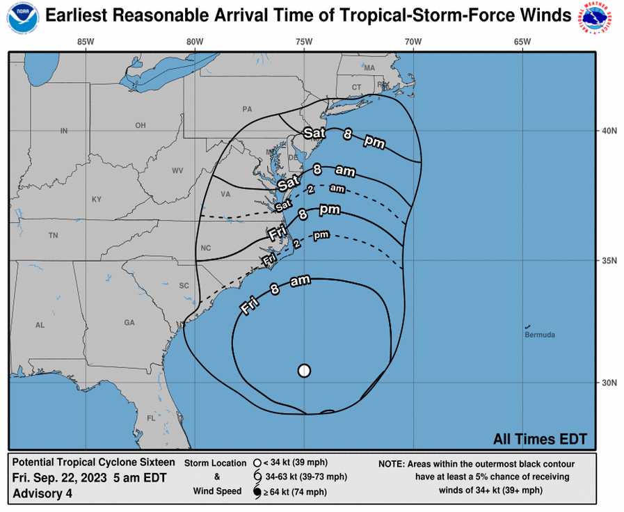
Tropical Storm Ophelia is brewing off the southeast U.S. and is set to make its way up the coast and right over the D.C. area. It will bring with it heavy rain and strong winds.
The rain is expected to start late tonight but the storm will be at its peak Saturday afternoon and evening.
Here in Arlington, flooding along the coastline is expected Saturday, and local streams may also top their banks due to several inches of rain.
“Widespread rainfall amounts of 2 to 4 inches are expected, with localized amounts up to 5 inches possible,” the National Weather Service said in an advisory today. “This may result in isolated instances of flooding, especially for low lying and flood prone areas. The heaviest rain is most likely to occur Saturday into Saturday night.”
Those planning to attend outdoor events this weekend should keep an eye on the weather and monitor for possible cancellations.
The wind, meanwhile, could cause some power outage.

NWS issued a Wind Advisory this afternoon for Arlington and other parts of the area, starting Saturday.
…WIND ADVISORY IN EFFECT FROM 8 AM TO 8 PM EDT SATURDAY…
* WHAT…Northeast winds 20 to 30 mph with gusts up to 45 mph expected. Gusts up to 50 mph are likely along the immediate shore of the Chesapeake Bay and Tidal Potomac.
* WHERE…Portions of central, northeast and southern Maryland, The District of Columbia and central and northern Virginia.
* WHEN…From 8 AM to 8 PM EDT Saturday.
* IMPACTS…Gusty winds could blow around unsecured objects. Tree limbs could be blown down and a few power outages may result.
* ADDITIONAL DETAILS…The combination of a long period of gusty winds and increasingly saturated grounds from rain will result in a higher likelihood for downed trees across the area.
NWS also previously issued Coastal Flood watches and advisories.
District of Columbia-Arlington/Falls Church/Alexandria-
850 AM EDT Fri Sep 22 2023…COASTAL FLOOD ADVISORY IN EFFECT FROM MIDNIGHT TONIGHT TO 6 AM EDT SATURDAY…
…COASTAL FLOOD WATCH NOW IN EFFECT FROM SATURDAY MORNING THROUGH LATE SATURDAY NIGHT…* WHAT…For the Coastal Flood Advisory, up to one half foot of inundation above ground level expected in low lying areas due to tidal flooding. For the Coastal Flood Watch, up to one foot of inundation above ground level possible in low lying areas due to tidal flooding.
* WHERE…Shoreline in the District of Columbia, Arlington County, and the City of Alexandria.
* WHEN…For the Coastal Flood Advisory, from midnight tonight to 6 AM EDT Saturday, especially around the time of high tide. For the Coastal Flood Watch, from Saturday morning through late Saturday night, especially around the time of high tide.
* IMPACTS…Shoreline inundation is expected along portions of the seawall adjacent to Ohio Drive and the Hains Point Loop Road and near the Tidal Basin. Water is expected to approach the curb near the intersection of King Street and Strand Street in Alexandria.
* ADDITIONAL DETAILS…Tides one and a half to two feet above normal. The next high tide at Alexandria is at 1:59 PM and 2:19 AM. The next high tide at Washington Channel is at 1:41 PM and 2:01 AM.
PRECAUTIONARY/PREPAREDNESS ACTIONS…
If travel is required, allow extra time as some roads may be closed. Do not drive around barricades or through water of unknown depth. Take the necessary actions to protect flood-prone property.
While areas to the east are expected to see more significant impacts, local chapters of the American Red Cross said this morning that they’re gearing up for a disaster response.
More, below, via a press release.
As national preparedness month continues, the Red Cross of the National Capital & Greater Chesapeake region is making initial preparations to respond to potentially tropical storm-force wind and rain this weekend. Preparedness experts with the organization are also urging everyone to take action for this weekend’s severe weather and the worsening climate disasters in the DMV and on the Delmarva Peninsula—areas where the Red Cross has seen an increase in flood-related emergency responses in recent years.
According to NOAA National Centers for Environmental Information, in Maryland, the frequency of billion-dollar, weather-related disasters averaged more than five per year between 2018 and 2022— a 90% increase when compared with an average of less than three per year between 2008 and 2012.
Severe weather like this is part of a worsening national trend in which the American Red Cross has responded to nearly twice as many large disasters across the country as it did a decade ago.
With more climate-driven disasters upending lives and devastating communities, the Red Cross is racing to adapt its services and grow its disaster response capacity locally and across the country, while also funding new international programs on climate response and preparedness; as well as minimizing its own environmental footprint.
“Everyone should take a forecast for severe weather seriously—especially because we are in a climate crisis in the DMV, the U.S. and across the globe,” said Dale Kunce, CEO for the Red Cross of the National Capital & Greater Chesapeake Region. “Today is the day to get your emergency plans in place.”
WHAT EVERY HOUSEHOLD CAN DO NOW TO PREPARE
Take three lifesaving actions: get a kit, make a plan and be informed — to help protect yourself and your household against local emergencies. Follow safety tips now at redcross.org/prepare. You can also deliver relief and care to families facing emergencies and climate disasters by becoming a Red Cross volunteer at redcross.org/VolunteerToday.

