Update at 10:30 a.m. — The Flood Warning expired and the Flash Flood Watch, originally in effect until this afternoon, has been cancelled as the rain moves out.
Earlier: Arlington County is under a Flood Warning this morning.
The warning was issued shortly after 5 a.m. Already areas of minor flooding have been reported, including high standing water along I-66 between East Falls Church and Ballston, which closed all but one eastbound lane, according to the National Weather Service.
The warning is in effect until 7:45 a.m.
More from NWS:
509 AM EDT THU SEP 23 2021
…FLOOD WARNING REMAINS IN EFFECT UNTIL 745 AM EDT THIS MORNING FOR SOUTHEASTERN MONTGOMERY, ARLINGTON AND EASTERN FAIRFAX COUNTIES AND THE NORTHWESTERN DISTRICT OF COLUMBIA, THE CITY OF ALEXANDRIA AND THE CITY OF FALLS CHURCH…
AT 509 AM EDT, DOPPLER RADAR INDICATED THE FIRST AREA OF HEAVY RAIN HAS EXITED THE WARNED AREA. BETWEEN 0.5 AND 1.5 INCHES OF RAIN HAVE FALLEN, WHICH RESULTED IN SOME MINOR URBAN AND POOR DRAINAGE FLOODING. ADDITIONAL MODERATE TO HEAVY RAIN IS EXPECTED TO MOVE ACROSS THE AREA OVER THE NEXT SEVERAL HOURS, WHICH COULD LEAD TO ADDITIONAL FLOODING.
SOME LOCATIONS THAT WILL EXPERIENCE FLOODING INCLUDE… ARLINGTON… ALEXANDRIA… GERMANTOWN… ROCKVILLE… BETHESDA… GAITHERSBURG… ANNANDALE… OLNEY… SPRINGFIELD… FORT HUNT… VIENNA… GROVETON… FALLS CHURCH… HUNTINGTON… FORT BELVOIR… PIMMIT HILLS… MCLEAN… AMERICAN LEGION BRIDGE… ROSSLYN… CRYSTAL CITY…
ADDITIONAL RAINFALL AMOUNTS OF 0.5 TO 1.5 INCHES ARE POSSIBLE IN THE WARNED AREA.
PRECAUTIONARY/PREPAREDNESS ACTIONS…
TURN AROUND, DON’T DROWN WHEN ENCOUNTERING FLOODED ROADS. MOST FLOOD DEATHS OCCUR IN VEHICLES.
BE ESPECIALLY CAUTIOUS AT NIGHT WHEN IT IS HARDER TO RECOGNIZE THE DANGERS OF FLOODING.
620a: Heavy downpours cycling through DC region from south to north. Expect these to continue for at least another hour. pic.twitter.com/x4tXwSx6ZD
A rainy night and morning are on tap for Arlington, leading the National Weather Service to issue a Flash Flood Watch.
D.C., Alexandria and points north and west are also included in the watch.
More from NWS:
Flooding/Flash Flooding possible through Thursday morning (along/west of Blue Ridge Mts) and early Thursday afternoon (areas further N/E). Also, a threat for severe thunderstorms this afternoon and evening with main impacts being damaging winds and an isolated tornado. pic.twitter.com/aGUKPpOQms
…FLASH FLOOD WATCH IN EFFECT FROM LATE TONIGHT THROUGH THURSDAY AFTERNOON…
THE NATIONAL WEATHER SERVICE IN STERLING VIRGINIA HAS EXPANDED THE
* FLASH FLOOD WATCH TO INCLUDE PORTIONS OF DC, MARYLAND AND NORTHERN VIRGINIA, INCLUDING THE FOLLOWING AREAS: IN DC, DISTRICT OF COLUMBIA. IN MARYLAND, CARROLL, CECIL, CENTRAL AND SOUTHEAST HOWARD, CENTRAL AND SOUTHEAST MONTGOMERY, NORTHERN BALTIMORE, NORTHWEST HARFORD, NORTHWEST HOWARD, NORTHWEST MONTGOMERY, SOUTHEAST HARFORD AND SOUTHERN BALTIMORE. IN NORTHERN VIRGINIA, ARLINGTON/FALLS CHURCH/ALEXANDRIA, EASTERN LOUDOUN AND FAIRFAX.
* FROM LATE TONIGHT THROUGH THURSDAY AFTERNOON.
* MULTIPLE ROUNDS OF SHOWERS AND SCATTERED THUNDERSTORMS CAPABLE OF PRODUCING HEAVY RAIN ARE EXPECTED THROUGH THURSDAY AFTERNOON. THE MOST WIDESPREAD HEAVY RAIN IS MOST LIKELY LATE TONIGHT THROUGH EARLY THURSDAY AFTERNOON. AVERAGE RAINFALL AMOUNTS OF 1 TO 2 INCHES ARE EXPECTED, WITH LOCALIZED HIGHER AMOUNTS OF UP TO 4 INCHES POSSIBLE. HEAVY RAIN FALLING OVER INCREASINGLY SATURATED GROUND MAY RESULT IN FLASH FLOODING.
PRECAUTIONARY/PREPAREDNESS ACTIONS…
YOU SHOULD MONITOR LATER FORECASTS AND BE PREPARED TO TAKE ACTION SHOULD FLASH FLOOD WARNINGS BE ISSUED.
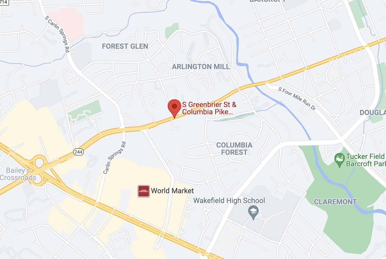
Intersection of Columbia Pike and S. Greenbrier Street – via Google Maps
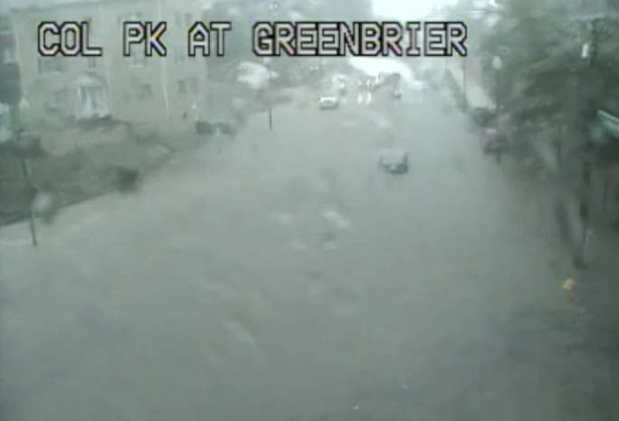
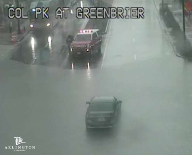
(Updated at 4:50 p.m.) Floodwaters have receded after Columbia Pike was blocked at S. Greenbrier Street around 3:30 this afternoon.
At least one car was stuck in the high water, near the 55 Hundred apartments, just west of the county line, prompting a water rescue operation. Other traffic could be seen turning around.
Firefighters successfully rescued the driver of the vehicle that was stuck, according to scanner traffic.
Insane flash flooding earlier this afternoon at Columbia Pike and S Greenbrier St in Arlington. A car was stuck in the middle of the floodwater. @wusa9 🎥: Edgar Sabalu pic.twitter.com/rpTxuClv5Q
Reports of flooding came as the National Weather Service issued a new Flood Warning for the county. Just before 4 p.m., a Flash Flood Warning was also issued.
From NWS:
Flash Flood Warning including Arlington VA, Annandale VA, West Falls Church VA until 7:00 PM EDT pic.twitter.com/8DkOLtI6d6
THE NATIONAL WEATHER SERVICE IN STERLING VIRGINIA HAS ISSUED A
* FLOOD WARNING…
* UNTIL 930 PM EDT THURSDAY.
* AT 321 PM EDT, DOPPLER RADAR INDICATED HEAVY RAIN DUE TO THUNDERSTORMS. FLOODING IS ONGOING OR EXPECTED TO BEGIN SHORTLY IN THE WARNED AREA. BETWEEN 1 AND 1.5 INCHES OF RAIN HAVE FALLEN.
* SOME LOCATIONS THAT WILL EXPERIENCE FLOODING INCLUDE… ARLINGTON… ALEXANDRIA… BETHESDA… RESTON… ANNANDALE… SPRINGFIELD… FORT WASHINGTON… FAIRFAX… LANGLEY PARK… FORT HUNT… VIENNA… GROVETON… FALLS CHURCH… HUNTINGTON… CORAL HILLS… BLADENSBURG… MANTUA… PIMMIT HILLS… NATIONAL HARBOR… ROSSLYN…
ADDITIONAL RAINFALL AMOUNTS OF 1 TO 2 INCHES ARE POSSIBLE IN THE WARNED AREA.
PRECAUTIONARY/PREPAREDNESS ACTIONS…
TURN AROUND, DON’T DROWN WHEN ENCOUNTERING FLOODED ROADS. MOST FLOOD DEATHS OCCUR IN VEHICLES.
In addition to the Pike flooding, high standing water was reported along I-395.
Flooding on 395 leaving VA right before the 14th street bridge. Cars are getting stuck. pic.twitter.com/luu4Vu15Jd
Previously, NWS issued a Flash Flood Watch for the area, effective until 9 p.m.
The rain has already cancelled at least one local event, a pop-up jazz performance in Rosslyn.
☔ Due to incoming storms, this evening's Pop-Up performance at Continental Beer Garden has been canceled for the safety of our performers, equipment and guests. We're looking forward to this Saturday's #RosslynJazz Festival at Gateway Park: https://t.co/I8LZoyBpaCpic.twitter.com/NNkgER3A8O
(Updated at 9:25 p.m.) Arlington County and the immediate D.C. area, as well as points north, are under a Severe Thunderstorm Watch tonight.
The watch is in effect until midnight. Forecasters say an approaching cold front will bring storms and potentially damaging winds to the area over the next few hours. Heavy rain and hail are also expected.
Just before 9:30 p.m., a Flash Flood Watch was also issued for Arlington. The watch is in effect until 4 a.m.
More from the National Weather Service:
924 PM EDT WED SEP 8 2021
…FLASH FLOOD WATCH IN EFFECT UNTIL 4 AM EDT THURSDAY…
THE NATIONAL WEATHER SERVICE IN STERLING VIRGINIA HAS EXPANDED THE
* FLASH FLOOD WATCH TO INCLUDE PORTIONS OF DC, CENTRAL MARYLAND AND NORTHERN VIRGINIA, INCLUDING THE FOLLOWING AREAS: IN DC, DISTRICT OF COLUMBIA. IN CENTRAL MARYLAND, ANNE ARUNDEL AND PRINCE GEORGES. IN NORTHERN VIRGINIA, ARLINGTON/FALLS CHURCH/ALEXANDRIA, EASTERN LOUDOUN, FAIRFAX, PRINCE WILLIAM/MANASSAS/MANASSAS PARK AND WESTERN LOUDOUN.
* UNTIL 4 AM EDT THURSDAY.
* SHOWERS AND SCATTERED THUNDERSTORMS ARE EXPECTED TONIGHT. AVERAGE RAINFALL AMOUNTS OF ONE-HALF TO ONE INCH IS EXPECTED. HOWEVER, THUNDERSTORMS WILL CONTAIN VERY HEAVY RAINFALL WITH RAINFALL RATES AROUND 1 TO 3 INCHES PER HOUR. LOCALIZED RAINFALL AMOUNTS OF 2 TO 4 INCHES ARE POSSIBLE.
* HEAVY AMOUNTS OF RAIN IN A SHORT PERIOD OF TIME MAY CAUSE CREEKS AND STREAMS TO RAPIDLY RISE OUT OF THEIR BANKS AS WELL AS THE POTENTIAL FOR FLASH-FLOODING IN URBAN AREAS.
PRECAUTIONARY/PREPAREDNESS ACTIONS…
YOU SHOULD MONITOR LATER FORECASTS AND BE PREPARED TO TAKE ACTION SHOULD FLASH FLOOD WARNINGS BE ISSUED.
A Severe Thunderstorm Watch has been issued for parts of Maryland and southern Pennsylvania until Midnight EDT. The main threats will be damaging winds and hail. Follow @NWS_BaltWash and @NWSStateCollege for the latest warning information. pic.twitter.com/LfTUXJtiQP
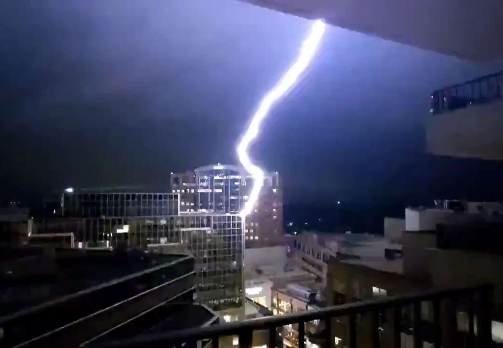
Screenshot of lightning striking above Ballston Quarter (via Jordan Tessler/@terpweather)
Screenshot of lightning striking above Ballston Quarter (via Jordan Tessler/@terpweather)
(Updated at 11:50 a.m.) If the early morning lightning storm didn’t wake you up, congratulations: you’re either an exceptionally deep sleeper or have some very high quality windows.
A supercell thunderstorm spawned ahead of the remnants of Hurricane Ida brought exceptionally frequent lightning and thunder to the area between 3-4 a.m. The light show and the loud booms awakened numerous local residents, not to mention their dogs and kids.
One Ballston resident and weather enthusiast even captured a bolt of lightning striking a building above Ballston Quarter mall.
Yeah, that'll get your attention, when lightning strikes across the street. Noped out of the doorway and straight into bed pic.twitter.com/TVfAYj6A8m
The bolt — one among many during the storm, which also packed torrential rainfall and prompted both a Flood Warning and a Severe Thunderstorm Warning — set off fire alarms in the area.
Severe Thunderstorm Warning for Arlington, Fairfax, City of Alexandria, City of Fairfax, City of Falls Church until 3:45PM. Possible hazards include 60mph wind gusts, heavy rain, and frequent lightning. #vawxpic.twitter.com/PXX0DYFYsF
A map of the lightning strikes last night, below, shows the degree to which Arlington was peppered by mother nature’s fury.
Lightning strikes early Wednesday morning (via lightningmaps.org)
Luckily, there were no reports of major flooding in Arlington as a result of the storm, unlike parts of Fairfax County and Montgomery County, where water rescues took place. There were some reports of storm damage, including a large tree branch that went through a home’s roof near the intersection of Military Road and Route 29 in Cherrydale, at least one tree down along the GW Parkway, and multiple trees down on Roosevelt Island.
A Flash Flood Watch for Arlington and the region remains in effect through Thursday morning.
Be Weather Aware Today (Wed) & Tonight! Tornado and Flash Flooding Threat. Be ready to act if NWS warnings are issued for your area. Also be aware of ongoing flooding in some locations along the I-95 corridor this A.M. If you encounter a flooded road, Turn Around/Don't Drown. pic.twitter.com/P60d8wy684
As our Warm Front pushed north, SPC has outlined areas east of the Blue Ridge for a likely Tornado Watch. Atmosphere to start destabilizing, leading to more severe conditions. Watching closely. #vawx#mdwx#dcwx#tornado#dmvpic.twitter.com/e75GtHfL3s
Expected track of the remnants of Hurricane Ida (via National Weather Service)
(Updated at noon) The remnants of Hurricane Ida are heading our way, and forecasters are already warning of potential flooding.
Ida has ravaged portions of Louisiana and Mississippi since making landfall as a Category 4 storm Sunday afternoon. It knocked out power to more than a million homes and businesses, including the entire city of New Orleans; interrupted 911 service; and caused catastrophic flooding, prompting numerous water rescues.
Now a tropical storm, Ida is on a northeasterly track that is expected to put its remnants squarely over the D.C. area starting Wednesday.
Two days ahead of Ida’s arrival, the National Weather Service this morning issued a Flash Flood Watch, to take effect from 11 a.m. Wednesday to 8 a.m. Thursday. Some 2-5 inches of rain could fall during that time.
Forecasters are also warning of the potential for severe weather or even tornadoes spawned by Ida.
“Heavy tropical rainfall could result in considerable flash flooding,” NWS wrote. “A few severe thunderstorms are possible Wednesday into Wednesday night. Damaging wind gusts and a brief tornado are the main threats.”
More from NWS:
…FLASH FLOOD WATCH IN EFFECT FROM WEDNESDAY MORNING THROUGH THURSDAY MORNING…
The National Weather Service in Sterling Virginia has issued a
* Flash Flood Watch for portions of DC, Maryland and Virginia…
* From Wednesday morning through Thursday morning.
* The remnants of Ida will interact with a stalled front, resulting in a prolonged period of heavy rainfall beginning Wednesday morning and continuing through Wednesday night. Rainfall amounts of 2 to 4 inches are expected, with localized amounts up to 6 inches possible.
* This amount of heavy rainfall will not only result in the potential for considerable flash flooding of creeks, small streams, and urban areas, but also the potential for river flooding on the main stem rivers.
PRECAUTIONARY/PREPAREDNESS ACTIONS…
You should monitor later forecasts and be prepared to take action should Flash Flood Warnings be issued.
Strong storms are also possible tonight (Monday), with the arrival of a cold front that will end our stretch of sweltering weather and temperatures in the 90s.
“Isolated damaging wind gusts are possible this afternoon and evening,” NWS wrote. “An isolated instance of flooding is also possible.”
Just before noon, a Flash Flood Watch was issued for Monday afternoon.
1148 AM EDT Mon Aug 30 2021
…FLASH FLOOD WATCH IN EFFECT UNTIL 10 PM EDT THIS EVENING…
…FLASH FLOOD WATCH REMAINS IN EFFECT FROM WEDNESDAY MORNING
THROUGH THURSDAY MORNING…
The National Weather Service in Sterling Virginia has issued a
* Flash Flood Watch for portions of DC, Maryland and Virginia…
* Until 10 PM EDT this evening.
* Scattered to numerous showers and thunderstorms are likely this afternoon and evening, some of which may produce a few inches of rain in a short period of time.
* Heavy rainfall in a short period of time would result in rapid rises of water in small streams and creeks, and in urban and poor drainage areas.
PRECAUTIONARY/PREPAREDNESS ACTIONS…
You should monitor later forecasts and be prepared to take action should Flash Flood Warnings be issued.
A Flash Flood Watch is in effect from 2pm this afternoon through 10pm this evening. Showers and strong thunderstorms will develop and push eastward across the region. Aside from gusty winds and hail, this activity will bring heavy downpours which could lead to flash flooding. pic.twitter.com/LvK8ySuDtp
Get ready for another stormy afternoon — and possible flooding.
The National Weather Service has issued a Flash Flood Watch for Arlington and the immediate D.C. region. The watch, which takes effect at 1 p.m., cautions that heavy rain which can cause dangerous, rapid flooding is expected this afternoon and evening.
Yesterday’s afternoon thunderstorm toppled trees around Arlington and knocked out power to several thousand homes and businesses. No significant flooding was reported locally, but the storm left the ground waterlogged and thus increased the chances of flooding today.
More from NWS:
A Flash Flood Watch has been issued for areas along the I-95 corridor this afternoon into tonight. Showers and thunderstorms are likely to bring heavy rainfall, which could lead to instances of flash flooding, especially in urban areas. pic.twitter.com/8TRQXYpqgA
…FLASH FLOOD WATCH IN EFFECT FROM 1 PM EDT THIS AFTERNOON THROUGH THIS EVENING…
The National Weather Service in Sterling Virginia has issued a
* Flash Flood Watch for portions of DC, central Maryland and northern Virginia, including the following areas: in DC, District of Columbia. In central Maryland, Central and Southeast Howard, Central and Southeast Montgomery and Prince Georges. In northern Virginia, Arlington/Falls Church/Alexandria and Fairfax.
* From 1 PM EDT this afternoon through this evening.
* Numerous showers and thunderstorms are expected this afternoon and evening. Average rainfall amounts are expected to be between one half to one inch. However, thunderstorms will be capable of producing very heavy rainfall rates of 2 to 3 inches per hour, causing localized amounts of 2 to 4 inches possible. While storms are possible any time this afternoon through this evening, the most widespread thunderstorm activity is most likely to be late this afternoon through early this evening.
* Heavy rainfall amounts in a short period of time may result in rapid rises on streams and creeks as well as the potential for flash flooding in urban areas.
PRECAUTIONARY/PREPAREDNESS ACTIONS…
You should monitor later forecasts and be prepared to take action should Flash Flood Warnings be issued.
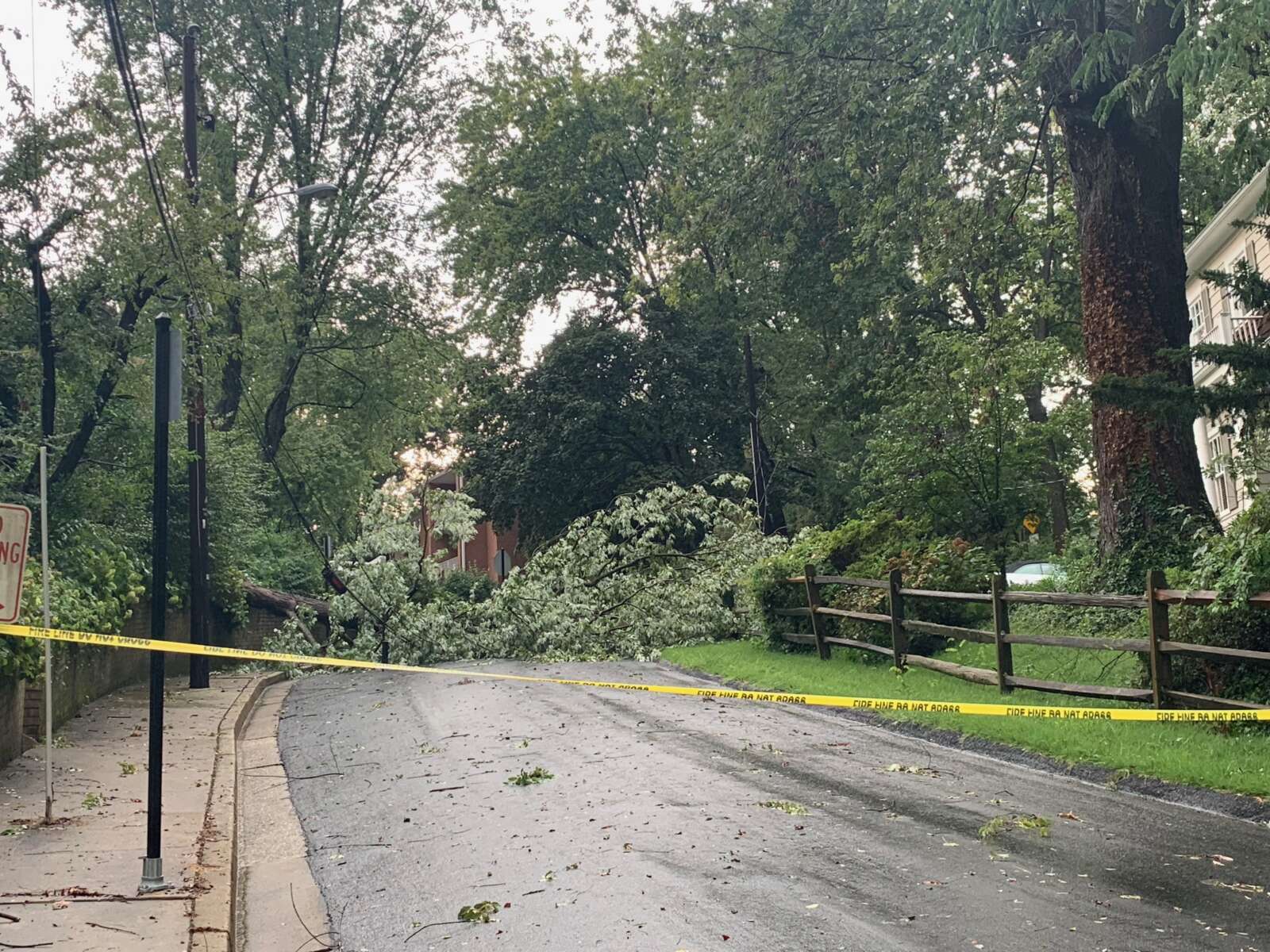
Update at 4:25 p.m. — “Multiple trees” are reported to be down near the intersection of 14th Street S. and S. Pollard Street in Douglas Park, and along I-66 near the Lee Highway/Route 29 exit, according to the National Weather Service.
Update at 4:10 p.m. — Thousands are without power in Arlington as a result of the storm. Nearly 3,500 homes and businesses are in the dark, according to a Dominion outage map.
Damage is being reported as a result of the storm’s strong winds. On 22nd Street N. at Military Road firefighters are on scene of a large tree that fell, took down power lines and caused a reported transformer explosion. On the 3900 block of Vacation Lane, a tree reportedly fell into a house.
The outages are causing problems, meanwhile, like a reported stuck elevator with people in it at the Costco in Pentagon City.
Local residents have been reporting hail, booming thunder, and standing water in roadways throughout the county. The Severe Thunderstorm Warning has been extended until 4:45 p.m. and northern Arlington is under a new warning.
Severe Thunderstorm Warning including Silver Spring MD, Bethesda MD, McLean VA until 4:45 PM EDT pic.twitter.com/4uGyTLyuCB
Update at 3:50 p.m. — The storm appears to be expanding on radar. In Ballston, very strong winds have knocked down furniture in sidewalk cafes.
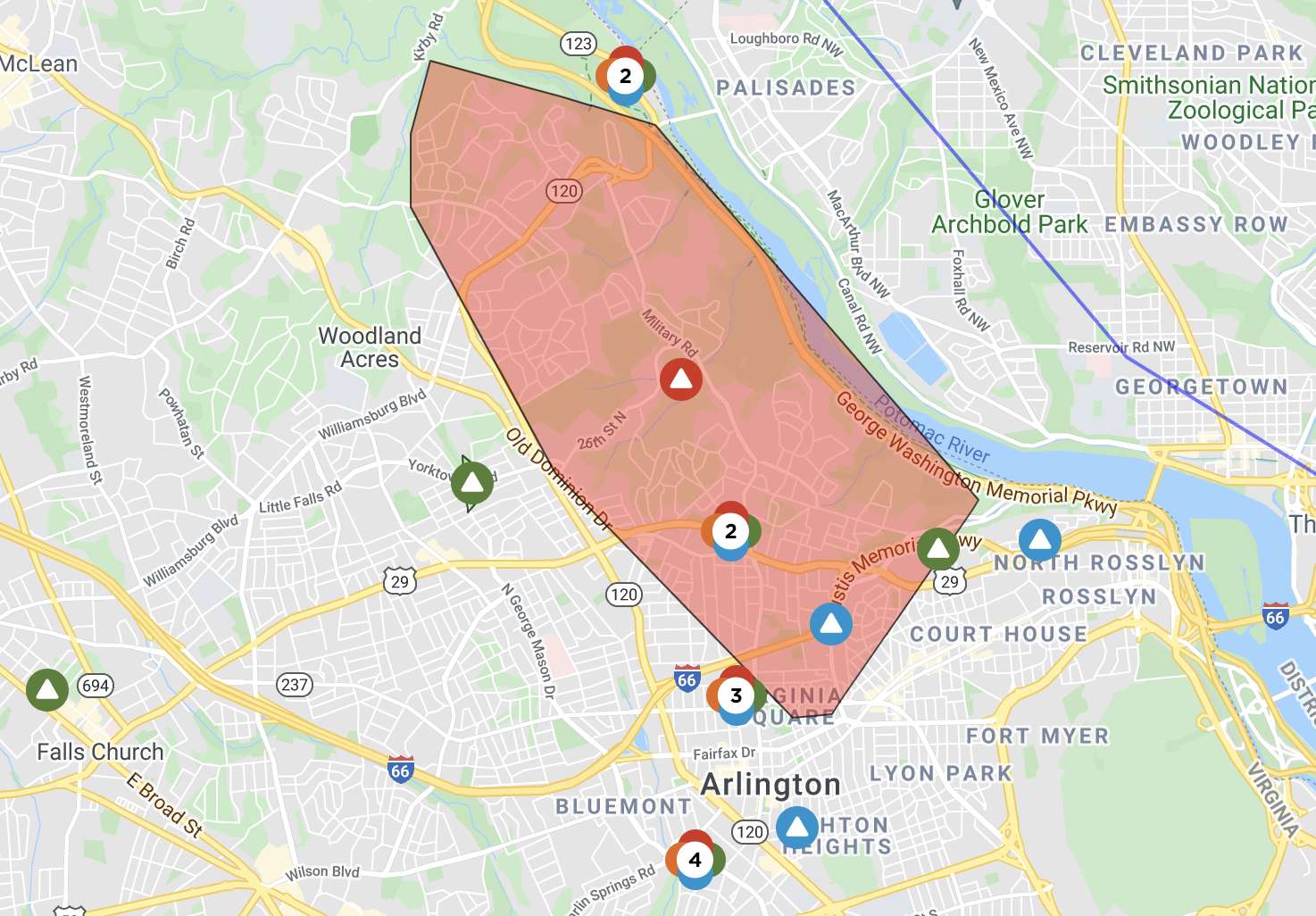
The National Weather Service, meanwhile, just issued a Flood Warning for Arlington.
DISTRICT OF COLUMBIA DC-ARLINGTON VA-
345 PM EDT THU AUG 26 2021
THE NATIONAL WEATHER SERVICE IN STERLING VIRGINIA HAS ISSUED A
* FLOOD WARNING FOR… WEST CENTRAL DISTRICT OF COLUMBIA… ARLINGTON COUNTY IN NORTHERN VIRGINIA…
* UNTIL 645 PM EDT.
* AT 345 PM EDT, DOPPLER RADAR INDICATED HEAVY RAIN DUE TO THUNDERSTORMS. FLOODING IS ONGOING OR EXPECTED TO BEGIN SHORTLY IN THE WARNED AREA. BETWEEN 0.5 AND 1 INCH OF RAIN HAS FALLEN.
* SOME LOCATIONS THAT WILL EXPERIENCE FLOODING INCLUDE… ARLINGTON… ALEXANDRIA… ROSSLYN… CRYSTAL CITY… REAGAN NATIONAL AIRPORT… NATIONALS PARK… GEORGETOWN… BALLSTON… ROCK CREEK… THE WHITE HOUSE… CHERRYDALE… BARCROFT… THE MALL…
ADDITIONAL RAINFALL AMOUNTS OF 1 TO 2 INCHES ARE POSSIBLE IN THE WARNED AREA.
PRECAUTIONARY/PREPAREDNESS ACTIONS…
TURN AROUND, DON’T DROWN WHEN ENCOUNTERING FLOODED ROADS. MOST FLOOD DEATHS OCCUR IN VEHICLES.
#BREAKING: New Flood Warning has been issued for portions of Arlington and DC until 6:45PM. Between 0.5-1 inch of rain has fallen and an additional 1-2 inches possible. Turn around, don`t drown when encountering flooded roads. #VAwx#DCwxhttps://t.co/WUO6CybhRO
— Washingtonian Weather Geeks (@WashingtonianWx) August 26, 2021
Earlier: Most of Arlington is under a Severe Thunderstorm Warning.
The warning was issued after a strong storm popped up over Arlington and Alexandria, with heavy rain and frequent lightning.
More from the National Weather Service:
BULLETIN – IMMEDIATE BROADCAST REQUESTED
SEVERE THUNDERSTORM WARNING
NATIONAL WEATHER SERVICE BALTIMORE MD/WASHINGTON DC
331 PM EDT THU AUG 26 2021
THE NATIONAL WEATHER SERVICE IN STERLING VIRGINIA HAS ISSUED A
* SEVERE THUNDERSTORM WARNING FOR… THE DISTRICT OF COLUMBIA… WEST CENTRAL PRINCE GEORGES COUNTY IN CENTRAL MARYLAND… ARLINGTON COUNTY IN NORTHERN VIRGINIA… EAST CENTRAL FAIRFAX COUNTY IN NORTHERN VIRGINIA… THE CITY OF ALEXANDRIA IN NORTHERN VIRGINIA…
* UNTIL 415 PM EDT.
* AT 331 PM EDT, A SEVERE THUNDERSTORM WAS LOCATED OVER ARLINGTON, MOVING NORTHEAST AT 10 MPH.
HAZARD…60 MPH WIND GUSTS.
SOURCE…RADAR INDICATED.
IMPACT…DAMAGING WINDS WILL CAUSE SOME TREES AND LARGE BRANCHES TO FALL. THIS COULD INJURE THOSE OUTDOORS, AS WELL AS DAMAGE HOMES AND VEHICLES. ROADWAYS MAY BECOME BLOCKED BY DOWNED TREES. LOCALIZED POWER OUTAGES ARE POSSIBLE. UNSECURED LIGHT OBJECTS MAY BECOME PROJECTILES.
* LOCATIONS IMPACTED INCLUDE… ARLINGTON, ALEXANDRIA, ANNANDALE, HUNTINGTON, CORAL HILLS, BLADENSBURG, NATIONAL HARBOR, NATIONALS PARK, FEDEX FIELD, HOWARD UNIVERSITY, GALLAUDET UNIVERSITY, FORT TOTTEN, REAGAN NATIONAL AIRPORT, ROSSLYN, CRYSTAL CITY, RFK STADIUM, LANDOVER, LINCOLNIA, HYATTSVILLE AND TAKOMA PARK.
PRECAUTIONARY/PREPAREDNESS ACTIONS…
FOR YOUR PROTECTION MOVE TO AN INTERIOR ROOM ON THE LOWEST FLOOR OF A BUILDING.
Severe Thunderstorm Warning including Washington DC, Arlington VA, Alexandria VA until 4:15 PM EDT pic.twitter.com/g8mtdbckQg
— Matt Ritter, Multi-Platform Meteorologist (@MetMattRitter) August 20, 2021
Update at 9:15 a.m. — Heavy rain continues around Arlington, though no major flood-related issues have been reported in the county as of yet. One possibly weather-related incident has closed all lanes of the GW Parkway, however: a tree has fallen across the parkway, blocking all lanes just south of Chain Bridge.
LOCATION: GW Parkway South of Chain Bridge INCIDENT: Trees Down IMPACT: All lanes of GW Parkway NB and SB are blocked. Seek Alternate Routes. pic.twitter.com/OLb8UZhFVO
BULLETIN – EAS ACTIVATION REQUESTED
FLASH FLOOD WARNING
NATIONAL WEATHER SERVICE BALTIMORE MD/WASHINGTON DC
755 AM EDT FRI AUG 20 2021
THE NATIONAL WEATHER SERVICE IN STERLING VIRGINIA HAS ISSUED A
* FLASH FLOOD WARNING FOR… DISTRICT OF COLUMBIA… SOUTH CENTRAL MONTGOMERY COUNTY IN CENTRAL MARYLAND… NORTHEASTERN ARLINGTON COUNTY IN NORTHERN VIRGINIA…
* UNTIL NOON EDT.
* AT 755 AM EDT, DOPPLER RADAR INDICATED SHOWERS PRODUCING HEAVY RAIN ACROSS THE WARNED AREA. BETWEEN 1 AND 1.5 INCHES OF RAIN HAVE FALLEN. ADDITIONAL RAINFALL AMOUNTS OF 0.5 TO 1.5 INCHES ARE POSSIBLE IN THE WARNED AREA. FLASH FLOODING IS ONGOING OR EXPECTED TO BEGIN SHORTLY.
THE NATIONAL WEATHER SERVICE IN STERLING VIRGINIA HAS ISSUED A
* FLOOD WARNING FOR… DISTRICT OF COLUMBIA… SOUTHEASTERN MONTGOMERY COUNTY IN CENTRAL MARYLAND… NORTHWESTERN PRINCE GEORGES COUNTY IN CENTRAL MARYLAND… ARLINGTON COUNTY IN NORTHERN VIRGINIA… SOUTHEASTERN FAIRFAX COUNTY IN NORTHERN VIRGINIA… THE CITY OF ALEXANDRIA IN NORTHERN VIRGINIA… THE CITY OF FALLS CHURCH IN NORTHERN VIRGINIA…
* UNTIL 145 PM EDT FRIDAY.
* AT 735 AM EDT, DOPPLER RADAR INDICATED HEAVY RAIN. FLOODING IS ONGOING OR EXPECTED TO BEGIN SHORTLY IN THE WARNED AREA. BETWEEN 1 AND 2 INCHES OF RAIN HAVE FALLEN.
* SOME LOCATIONS THAT WILL EXPERIENCE FLOODING INCLUDE… ARLINGTON… ALEXANDRIA… BETHESDA… ANNANDALE… SPRINGFIELD… COLLEGE PARK… FORT WASHINGTON… GREENBELT… LANGLEY PARK… BELTSVILLE… FORT HUNT… GROVETON… FALLS CHURCH… HUNTINGTON… CORAL HILLS… BLADENSBURG… MANTUA… FORT BELVOIR… PIMMIT HILLS… NATIONAL HARBOR…
THIS INCLUDES THE FOLLOWING FLOOD PRONE ROADS:
MILITARY ROAD AT 36TH ROAD AT GULF BRANCH…
18TH STREET AT UPTON STREET…
17TH STREET NORTH AT NORTH BUCHANAN ST…
SOUTH TROY STREET NEAR LONG BRANCH…
WEST STREET NEAR BRADDOCK ROAD…
HOLMES RUN BELOW LAKE BARCROFT…
RHODE ISLAND AVE NE BETWEEN 2ND AND CAPITOL…
BEACH DR FROM BROAD BRANCH RD TO PINEY BRANCH PKWY…
WOODBURN ROAD AT ACCOTINK CREEK…
CONNECTICUT AVENUE JUST NORTH OF THE BELTWAY…
UNIVERSITY BOULEVARD AT SLIGO CREEK…
BEACH DRIVE ALONG ROCK CREEK…
SLIGO CREEK PARKWAY…
ADDITIONAL RAINFALL AMOUNTS OF 1 TO 2 INCHES ARE POSSIBLE IN THE WARNED AREA.
PRECAUTIONARY/PREPAREDNESS ACTIONS…
TURN AROUND, DON’T DROWN WHEN ENCOUNTERING FLOODED ROADS. MOST FLOOD DEATHS OCCUR IN VEHICLES.
The National Weather Service says that overnight downpours are expected and could cause flash flooding in the D.C. area.
More from NWS:
…FLASH FLOOD WATCH IN EFFECT FROM LATE TONIGHT THROUGH FRIDAY MORNING…
The National Weather Service in Sterling Virginia has issued a
* Flash Flood Watch for portions of DC, central Maryland and Virginia, including the following areas: in DC, District of Columbia. In central Maryland, Central and Southeast Montgomery, Northwest Montgomery and Prince Georges. In Virginia, Albemarle, Arlington/Falls Church/Alexandria, Central Virginia Blue Ridge, Culpeper, Eastern Loudoun, Fairfax, Greene, Madison, Nelson, Northern Fauquier, Northern Virginia Blue Ridge, Orange, Prince William/Manassas/Manassas Park, Rappahannock, Southern Fauquier, Spotsylvania, Stafford and Western Loudoun.
* From 2 AM EDT Friday through Friday morning.
* Scattered to numerous showers and thunderstorms are expected. Although isolated thunderstorms capable of heavy rain are possible this evening near and southwest of the DC metro area, the bulk of the threat is expected to be overnight into Friday morning. Thunderstorms may be capable of producing heavy rainfall of 1 to 2 inches per hour.
* Heavy rainfall may result in rapid rises on streams, creeks, and in urban and poor drainage areas. This will especially be the case where repetitive or persistent thunderstorm activity occurs.
PRECAUTIONARY/PREPAREDNESS ACTIONS…
You should monitor later forecasts and be prepared to take action should Flash Flood Warnings be issued.
Even more rain is expected during the day on Friday and into the weekend.
Conditions generally remain warm and humid the next several days. Each day will bring a chance for afternoon/evening showers and thunderstorms, along with the potential for isolated flooding. #MDwx#VAwx#DCwx#WVwxpic.twitter.com/2cBcwEp176
Forecasters say conditions are favorable for the formation of tornadoes, though any such storms should be isolated. Severe thunderstorms are also possible.
A Tornado Watch has been issued for our whole area. Rotating supercells from remnants of Fred may lead to Tornadoes this afternoon. Tornadoes will be brief, but may cause some damage. Stay Safe Out There! pic.twitter.com/iKZzzP6yZ7
— Washingtonian Weather Geeks (@WashingtonianWx) August 18, 2021
Arlington is no stranger to tornados, though twisters are a relatively uncommon occurrence.
Last month an EF-1 tornado caused damage across several neighborhoods near Lee Highway. In April 2017, an EF-0 tornado chopped trees in half at Army Navy Country Club and caused some damage at the Macy’s in Pentagon City. Before that, a long-lived EF-1 twister struck Arlington, Alexandria, Fairfax County and D.C. in 2001.
More from the National Weather Service:
A FLASH FLOOD WATCH REMAINS IN EFFECT THROUGH 10 PM FOR AREAS ALONG THE INTERSTATE 95 CORRIDOR. ISOLATED INSTANCES OF FLASH FLOODING ARE POSSIBLE AS TROPICAL MOISTURE OVERSPREADS THE REGION.
A TORNADO WATCH IS IN EFFECT UNTIL 8 PM. ISOLATED TORNADOES AND DAMAGING THUNDERSTORM WIND GUSTS ARE THE THREATS.
As Tropical Depression Fred passes off to the west, there will be a threat for isolated tornadoes, damaging winds, as well as flash flooding. The risk for severe thunderstorms may come as early as the mid-morning. Otherwise, conditions should improve by late this evening. pic.twitter.com/wAnqAVAqdi

")
")
")
")
")
")
")

")