File photo

It’s going to get quite windy tonight.

Today will be breezy but winds will whip up even more after dark, with gusts up to 50 mph overnight ahead of a cold front. That could result in downed trees and power outages.

The National Weather Service has issued a Wind Advisory, in effect from 10 p.m. until 10 a.m. Friday.

More from NWS:

349 AM EST Thu Feb 17 2022

…WIND ADVISORY IN EFFECT FROM 10 PM THIS EVENING TO 10 AM EST FRIDAY…

* WHAT…South to southwest winds 20 to 30 mph with gusts up to 50 mph expected. Winds will quickly turn northwest behind a cold front after 3 AM.

* WHERE…The Baltimore and Washington Metropolitan areas, northern Virginia, northern and central Maryland, and the eastern Panhandle of West Virginia.

* WHEN…From 10 PM this evening to 10 AM EST Friday.

* IMPACTS…Gusty winds could blow around unsecured objects. Tree limbs could be blown down and a few power outages may result.

PRECAUTIONARY/PREPAREDNESS ACTIONS…

Use extra caution when driving, especially if operating a high profile vehicle. Secure outdoor objects.


Sunday afternoon snow in Westover last month (staff photo by Jay Westcott)

Arlington is expected to get 1-2 inches of snow tomorrow, prompting the National Weather Service to issue a Winter Weather Advisory this morning.

The advisory cautions against slippery conditions on local roads as a result of the snow, which is expected to start falling overnight. The snow should wrap up before the kickoff of the Super Bowl Sunday evening.

The advisory from NWS is below.

1000 AM EST Sat Feb 12 2022

…WINTER WEATHER ADVISORY IN EFFECT FROM 1 AM TO 4 PM EST SUNDAY…

* WHAT…Snow expected. Total snow accumulations of 1 to 2 inches, with up to 4 inches locally.

* WHERE…The District of Columbia, portions of central, northeast and northern Maryland and central, northern and northwest Virginia.

* WHEN…From 1 AM to 4 PM EST Sunday.

* IMPACTS…Plan on slippery road conditions.

* ADDITIONAL DETAILS…The heaviest accumulations will be on non-paved surfaces.

PRECAUTIONARY/PREPAREDNESS ACTIONS…

Slow down and use caution while traveling.

When venturing outside, watch your first few steps taken on steps, sidewalks, and driveways, which could be icy and slippery, increasing your risk of a fall and injury.


If your outdoor plants are especially delicate, you might want to cover them or bring them inside today.

A Frost Advisory is in effect for early morning Friday, as temperatures in Arlington are expected to dip into the 30s overnight. Arlington is on the edge of a Freeze Warning, in effect for Fairfax County and other points north and west.

More from the National Weather Service:

1203 PM EDT Thu Apr 22 2021

…FROST ADVISORY IN EFFECT FROM 2 AM TO 9 AM EDT FRIDAY…

* WHAT…Temperatures in the middle 30s are expected to result in frost formation.

* WHERE…Portions of central and southern Maryland and northern and central Virginia east of Interstate 95, including Washington DC and Baltimore MD.

* WHEN…From 2 AM to 9 AM EDT Friday.

* IMPACTS…Frost could kill sensitive outdoor vegetation if left uncovered.

PRECAUTIONARY/PREPAREDNESS ACTIONS…

Take steps now to protect tender plants from the cold.


It’s going to be a windy Friday afternoon.

The National Weather Service just issued a Wind Advisory, warning of wind gusts up to 50 mph tomorrow in the D.C. area, including in Arlington. Expect downed tree limbs and some power outages, forecasters say.

More from NWS:

241 PM EDT THU MAR 25 2021

…WIND ADVISORY IN EFFECT FROM 11 AM TO 7 PM EDT FRIDAY…

* WHAT…WEST WINDS 20 TO 30 MPH WITH GUSTS UP TO 50 MPH
EXPECTED.

* WHERE…PORTIONS OF THE DISTRICT OF COLUMBIA, CENTRAL AND NORTHERN MARYLAND AND NORTHERN VIRGINIA.

* WHEN…FROM 11 AM TO 7 PM EDT FRIDAY.

* IMPACTS…GUSTY WINDS COULD BLOW AROUND UNSECURED OBJECTS. TREE LIMBS COULD BE BLOWN DOWN AND A FEW POWER OUTAGES MAY RESULT.

PRECAUTIONARY/PREPAREDNESS ACTIONS…

USE EXTRA CAUTION WHEN DRIVING, ESPECIALLY IF OPERATING A HIGH PROFILE VEHICLE. SECURE OUTDOOR OBJECTS.


Arlington County is under a Winter Weather Advisory through 9 a.m. Tuesday.

A mix of rain, freezing rain, sleet and snow is expected to fall tonight, with the precipitation likely to start around 6 p.m. Up to two inches of snow may accumulate, though if temperatures stay slightly warmer there may be little to no snow accumulation, forecasters say.

Both Arlington County and VDOT crews are pre-treating roads in advance of the winter weather.

“Crews are spot pre-treating areas in higher elevations today,” VDOT said. “About 400 trucks will be staging along roads this afternoon, ready to treat roads as precipitation begins. Tree crews will also be on alert in case of downed branches due to ice.”

More from the National Weather Service:

…WINTER WEATHER ADVISORY IN EFFECT UNTIL 9 AM EST TUESDAY…

WHAT… Mixed precipitation. Snow accumulations of 1 to 2 inches and ice accumulations around a trace.

WHERE… In Maryland, Prince Georges and Anne Arundel Counties. In District of Columbia… In Virginia, Fairfax County, and Arlington/Falls Church/Alexandria.

WHEN… Until 9 AM EST Tuesday.

IMPACTS… Plan on slippery road conditions. The hazardous conditions could impact the evening and morning commute.

PRECAUTIONARY/PREPAREDNESS ACTIONS… Slow down and use caution while traveling. When venturing outside, watch your first few steps taken on steps, sidewalks, and driveways, which could be icy and slippery, increasing your risk of a fall and injury.

File photo


(Updated at 3:10 p.m.) The worst of today’s fog is starting to lift after an earlier Dense Fog Advisory that was in effect for Arlington and surrounding areas

The fog has prompted delays at Reagan National Airport.

“Due to Low Ceilings, traffic is experiencing Gate Hold and Taxi delays between 16 minutes and 30 minutes in length and increasing,” said the FAA’s flight delay maps.

More of the advisory, from the National Weather Service:

…DENSE FOG ADVISORY REMAINS IN EFFECT UNTIL 4 PM EST THIS AFTERNOON… * WHAT…VISIBILITY ONE QUARTER MILE OR LESS IN DENSE FOG. * WHERE…PORTIONS OF THE DISTRICT OF COLUMBIA, CENTRAL, NORTH CENTRAL, NORTHERN AND SOUTHERN MARYLAND AND CENTRAL AND NORTHERN VIRGINIA. * WHEN…UNTIL 4 PM EST THIS AFTERNOON. * IMPACTS…HAZARDOUS DRIVING CONDITIONS DUE TO LOW VISIBILITY. PRECAUTIONARY/PREPAREDNESS ACTIONS… IF DRIVING, SLOW DOWN, USE YOUR HEADLIGHTS, AND LEAVE PLENTY OF DISTANCE AHEAD OF YOU. &&

On Twitter, Reagan National Airport tweeted earlier this afternoon that the fog completely hid its tower, as seen from nearby Crystal City.

https://twitter.com/Reagan_Airport/status/1207014684588740616

File photo (top) via Twitter/@Reagan_Airport


Arlington County and surrounding areas are under a Wind Advisory Sunday afternoon and evening.

The advisory was issued Saturday, ahead of what is expected to be a very breezy and potentially hazardous end to the weekend.

More from the National Weather Service:

…WIND ADVISORY IN EFFECT FROM 3 PM TO 10 PM EST SUNDAY… THE NATIONAL WEATHER SERVICE IN BALTIMORE MD/WASHINGTON HAS ISSUED A WIND ADVISORY, WHICH IS IN EFFECT FROM 3 PM TO 10 PM EST SUNDAY. * TIMING…SUNDAY AFTERNOON INTO SUNDAY EVENING. * WINDS…SOUTHWEST SUNDAY AFTERNOON, BECOMING WEST TO NORTHWEST SUNDAY EVENING 20 TO 35 MPH WITH GUSTS AROUND 50 TO 55 MPH. * IMPACTS…SCATTERED TREE AND POWER LINE DAMAGE. DIFFICULTY DRIVING HIGH PROFILE VEHICLES. PRECAUTIONARY/PREPAREDNESS ACTIONS… A WIND ADVISORY MEANS THAT WINDS OF 45 TO 55 MPH ARE EXPECTED. WINDS THIS STRONG CAN MAKE DRIVING DIFFICULT, ESPECIALLY FOR HIGH PROFILE VEHICLES. &&


Arlington and other parts of the D.C. area are under a Frost Advisory tonight.

Temperatures are expected to dip into the mid-30s early Wednesday morning, potentially damaging sensitive plants.

From the National Weather Service:

… FROST ADVISORY REMAINS IN EFFECT FROM 1 AM TO 9 AM EDT WEDNESDAY… * TEMPERATURES… DROPPING INTO THE MID 30S BY DAWN, ESPECIALLY AWAY FROM LARGER BODIES OF WATER AND URBAN AREAS. * IMPACTS… A FROST ADVISORY MEANS THAT WIDESPREAD FROST IS EXPECTED. SENSITIVE OUTDOOR PLANTS MAY BE KILLED IF LEFT UNCOVERED. PRECAUTIONARY/PREPAREDNESS ACTIONS… A FROST ADVISORY MEANS THAT WIDESPREAD FROST IS EXPECTED. SENSITIVE OUTDOOR PLANTS MAY BE KILLED IF LEFT UNCOVERED.


Ice / freezing rain on windshieldThe National Weather Service has issued a Winter Weather Advisory for Arlington and surrounding areas on Saturday.

County and VDOT crews are already pretreating roads ahead of the potentially snowy and slippery weather.

From NWS:

WINTER WEATHER ADVISORY IN EFFECT FROM MIDNIGHT TONIGHT TO 6 PM EST SATURDAY… THE NATIONAL WEATHER SERVICE IN BALTIMORE MD/WASHINGTON HAS ISSUED A WINTER WEATHER ADVISORY FOR SNOW… SLEET AND FREEZING RAIN… WHICH IS IN EFFECT FROM MIDNIGHT TONIGHT TO 6 PM EST SATURDAY. * PRECIPITATION TYPE… SNOW… SLEET… AND FREEZING RAIN. * ACCUMULATIONS… SNOW ACCUMULATION OF UP TO 1 INCH… ALONG WITH AROUND A TRACE OF ICE. * TIMING… LATE TONIGHT THROUGH SATURDAY. * IMPACTS… ICY PATCHES ON ROADS AND BRIDGES WILL MAKE TRAVEL DIFFICULT. * WINDS… EAST 5 MPH OR LESS. * TEMPERATURES… IN THE LOWER 30S. PRECAUTIONARY/PREPAREDNESS ACTIONS… A WINTER WEATHER ADVISORY MEANS THAT PERIODS OF SNOW… SLEET… AND FREEZING RAIN WILL CAUSE TRAVEL DIFFICULTIES. BE PREPARED FOR SLIPPERY ROADS AND LIMITED VISIBILITIES… AND USE CAUTION WHILE DRIVING.


All the salt spread on local roads and sidewalks for Thursday night’s snow non-event may come in handy after all.

The National Weather Service has included Arlington in a Winter Weather Advisory. Up to three inches of snow are expected to fall Saturday morning.

From the NWS:

… WINTER WEATHER ADVISORY IN EFFECT FROM 1 AM TO 1 PM EST SATURDAY… THE NATIONAL WEATHER SERVICE IN BALTIMORE MD/WASHINGTON HAS ISSUED A WINTER WEATHER ADVISORY FOR SNOW… WHICH IS IN EFFECT FROM 1 AM TO 1 PM EST SATURDAY. * PRECIPITATION TYPE… SNOW. * ACCUMULATIONS… SNOW ACCUMULATION OF 1 TO 3 INCHES. * TIMING… LATE TONIGHT THROUGH EARLY SATURDAY AFTERNOON. * IMPACTS… SNOW ON ROADS WILL RESULT IN TRAVEL IMPACTS. * WINDS… NORTH 10 TO 15 MPH WITH GUSTS UP TO 20 MPH. * TEMPERATURES… IN THE MID 20S. PRECAUTIONARY/PREPAREDNESS ACTIONS… A WINTER WEATHER ADVISORY FOR SNOW MEANS THAT PERIODS OF SNOW WILL CAUSE PRIMARILY TRAVEL DIFFICULTIES. BE PREPARED FOR SNOW COVERED ROADS AND LIMITED VISIBILITIES… AND USE CAUTION WHILE DRIVING. &&


Very heavy traffic during a snowy evening commute on Jan. 20, 2016Update at 3:20 p.m. — WMATA says Metrobuses will operate on a Moderate Snow Plan on Tuesday.

It’s an uncertain forecast in part due to above-freezing temperatures today, but forecasters say D.C. area residents should expect 1-3 inches of snow between late tonight and Tuesday night.

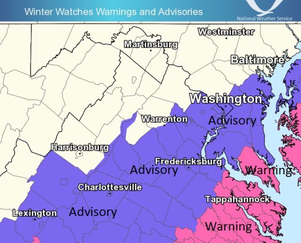
The National Weather Service has issued a Winter Weather Advisory, warning of the potential for snow accumulation disrupting driving tomorrow, particularly during the morning commute.

We all know what a measly inch of snow did during the nightmare evening commute a couple of weeks ago — though road crews are likely to be more prepared this time around.

The Clarendon-Courthouse Mardi Gras Parade, meanwhile, is once again being threatened by winter weather. On the parade’s website, organizers say they “will be making a weather announcement here mid-day on Tuesday, Feb. 9, about the parade,” which is scheduled for Tuesday night.

From the NWS:

… WINTER WEATHER ADVISORY IN EFFECT FROM 10 PM THIS EVENING TO MIDNIGHT EST TUESDAY NIGHT…

THE NATIONAL WEATHER SERVICE IN BALTIMORE MD/WASHINGTON HAS ISSUED A WINTER WEATHER ADVISORY FOR SNOW… WHICH IS IN EFFECT FROM 10 PM THIS EVENING TO MIDNIGHT EST TUESDAY NIGHT.

* PRECIPITATION TYPE… SNOW.

* ACCUMULATIONS… SNOW ACCUMULATION OF 1 TO 3 INCHES… WITH LOCALLY HIGHER AMOUNTS PARTICULARLY IN THE NORTHWEST SUBURBS.

* TIMING… A MIXTURE OF RAIN AND SNOW WILL DEVELOP THIS EVENING. PRECIPITATION WILL TURN TO ALL SNOW AROUND OR SHORTLY AFTER MIDNIGHT. PERIODS OF SNOW WILL CONTINUE INTO TUESDAY AND THE ADVISORY MAY NEED TO BE EXTENDED.

* IMPACTS… SNOW COVERED ROADS AND TRAVEL DISRUPTIONS.

* WINDS… NORTH 5 TO 10 MPH.

* TEMPERATURES… IN THE LOWER TO MIDDLE 30S.

PRECAUTIONARY/PREPAREDNESS ACTIONS…

A WINTER WEATHER ADVISORY FOR SNOW MEANS THAT PERIODS OF SNOW WILL CAUSE PRIMARILY TRAVEL DIFFICULTIES. BE PREPARED FOR SNOW COVERED ROADS AND LIMITED VISIBILITIES… AND USE CAUTION WHILE DRIVING.

VDOT, meanwhile, says drives should be prepared for the possibility of a messy commute Tuesday. From a press release:

The Virginia Department of Transportation asks drivers to plan now for their commutes Tuesday, as several inches of snow are forecast to impact both the morning and evening rush hours in northern Virginia. Drivers are asked to monitor forecasts for changes or heavier weather bands that may impact their schedule, and to plan accordingly to telework, delay commutes or allow extra time for a slow and cautious trip.

Crews have treated interstates and major roads in Fairfax, Loudoun and Prince William counties with brine and liquid magnesium chloride in advance of the snow. Tonight, about 1,450 trucks will pre-deploy along interstates, main roads and neighborhood streets. They will remain on duty to plow and treat roads through the day Tuesday.

VDOT reminds drivers to use extreme caution during winter weather, to reduce speeds, and to be aware of potential slick spots such as bridges, ramps, hills, curves and shaded areas.

Reminders for drivers and residents:

If possible, park in driveways or on the odd-numbered side of the street to allow plows room to pass.

If you must be on the road, check www.511virginia.org or use the mobile app before leaving for road conditions.

Follow @vadotnova on Twitter.

VDOT’s Northern Virginia District includes Loudoun, Fairfax, Prince William and Arlington counties (Arlington maintains its own secondary roads).


View More Stories