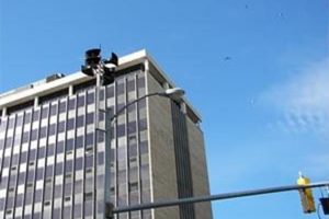
Arlington tested its outdoor warning system this morning (Thursday).

The county conducts an audible test of the warning system once or twice per year, according to Arlington Office of Emergency Management (OEM) Director Jack Brown. Residents in some of Arlington’s more urban areas would have heard a beep or series of beeps during the test, he said.

Arlington’s outdoor warning system was first installed in 2007, using $400,000 in funding from the Department of Homeland Security. The system includes six warning speakers: two in Rosslyn, one in Clarendon, one in Courthouse, and two in Pentagon City. The speakers are controlled by a line-of-sight radio signal.

According to Brown, he last time the speakers were used in an actual emergency was on July 4, 2007, when a severe storm was approaching the area while thousands were heading to sites like the Iwo Jima memorial for the Fourth of July fireworks display.

In addition to beeps or a siren, the speakers can broadcast a pre-recorded voice message. It’s the same type of system that’s used on military bases like Joint Base Myer-Henderson Hall, Brown said. While Fort Myer’s speakers play Taps at night and perform other non-emergency functions, however, the county’s system is only meant to be activated for true emergencies, like severe weather events, terrorist attacks, or other incidents.

Brown acknowledged that the system is only in earshot of those who are in some of the county’s more densely-populated areas, but said that it’s only one piece in a multi-platform emergency alert system that includes the county’s 1700 AM radio station, Arlington Alert emails, social media channels, a Reverse 911 system, and local media outreach.


The National Weather Service has issued a flash flood warning due to a line of thunderstorms approaching the area.

Forecasters say the storms could bring torrential rainfall of up to 1 to 2 inches.

THE NATIONAL WEATHER SERVICE IN STERLING VIRGINIA HAS ISSUED A

* FLASH FLOOD WARNING FOR… CITY OF FAIRFAX IN NORTHERN VIRGINIA… CITY OF FALLS CHURCH IN NORTHERN VIRGINIA… WESTERN ARLINGTON COUNTY IN NORTHERN VIRGINIA… CENTRAL FAIRFAX COUNTY IN NORTHERN VIRGINIA…

* UNTIL 1115 PM EDT

* AT 805 PM EDT… NATIONAL WEATHER SERVICE DOPPLER RADAR INDICATED THUNDERSTORMS PRODUCING TORRENTIAL RAINFALL ALONG A LINE EXTENDING FROM GREAT FALLS TO FAIRFAX… OR ALONG A LINE EXTENDING FROM THE AMERICA LEGION BRIDGE TO FAIRFAX… MOVING EAST AT 15 MPH.

* SOME LOCATIONS THAT WILL CONTINUE TO BE AFFECTED BY THE HEAVY RAIN INCLUDE ANNANDALE… ARLINGTON… BALLSTON… FAIRFAX… FALLS CHURCH… GREAT FALLS… LAKE BARCROFT… LINCOLNIA… MCLEAN… MERRIFIELD… OAKTON… THE I66 AND I495 INTERCHANGE… TYSONS CORNER… VIENNA… WOLF TRAP… MANTUA AND PIMMIT HILLS.

PRECAUTIONARY/PREPAREDNESS ACTIONS…

THIS INCLUDES THE FOLLOWING STREAMS AND DRAINAGES… NICHOLS RUN… DIFFICULT RUN… PIMMIT RUN… BULL RUN… ACCOTINK CREEK… ROCKY RUN… POPES HEAD CREEK… CASTLE CREEK… RABBIT BRANCH… SIDEBURN BRANCH… HOLMES RUN… TRIPPS RUN… BACKLICK RUN… INDIAN RUN… FOUR MILE RUN… LONG BRANCH… LITTLE PIMMIT RUN… BULLNECK RUN… ROCKY RUN… WOLFTRAP CREEK… ANGELICO BRANCH AND SOUTH RUN.

RAINFALL AMOUNTS OF 1 TO 2 INCHES ARE POSSIBLE IN THE WARNED AREA.

EXCESSIVE RUNOFF FROM HEAVY RAINFALL WILL CAUSE FLOODING OF SMALL CREEKS AND STREAMS… URBAN AREAS… HIGHWAYS… STREETS AND UNDERPASSES AS WELL AS OTHER DRAINAGE AREAS AND LOW LYING SPOTS.


(Updated at 12:25 p.m.) Police are encouraging residents to be on alert for a man caught masturbating in public while watching children across the street.

According to police spokesman Dustin Sternbeck, the man was first seen sitting on the sidewalk in between two cars with a newspaper over his lap, in the 1000 block of N. Fillmore Street in Clarendon, on Saturday, May 19. Staff from a restaurant across the street saw the man masturbating as he watched children playing on the restaurant patio.

Witnesses called the police, and one staff member walked across the street to ask the man to leave. He left without causing trouble. Police have not been able to locate him, and want residents to be aware of the incident.

“We’re putting the word out in light of several recent exposure incidents and sexual assaults,” Sternbeck said.

The children and other customers did not see the man; the act was only witnessed by restaurant staff.

He is described as a white man, around 60 years old, with medium length gray hair. At the time of the incident, he was wearing a black shirt, navy shorts and a dark colored hat.

Anyone who might encounter this man, or any other person, performing an indecent act in public is asked to call the police immediately. Police recommend not confronting the offender, as it’s not known if he might try to inflict harm.


Update at 3:10 p.m. — WMATA reports the Foggy Bottom station has reopened.

Earlier: Metro riders should expect to experience delays on the Orange and Blue lines due to a person struck by a train at Foggy Bottom.

The Foggy Bottom station is currently closed. Orange lines are single tracking between Clarendon and Foggy Bottom. Blue lines are single tracking between Arlington Cemetery and Foggy Bottom.

Delays are expected to continue during the police investigation into the incident.

If you or someone you know is experiencing thoughts of suicide, help is a phone call away. Call CrisisLink at 703-527-4077.


Get ready for some breezy weather tonight. The National Weather Service is predicting 20 to 30 mph sustained winds, with gusts up to 55 mph, starting late this afternoon.

The winds carry the possibility of blowing debris and downed power lines, among other hazards. From Arlington Alerts:

The National Weather Service has issued a Wind Advisory for Arlington County and other jurisdictions within the National Capital Region from 3 pm, Friday, February 24th, until midnight tonight. The strongest winds are expected to occur late this afternoon thru this evening with gusts up to 55 MPH. Winds this strong may make driving difficult, especially for high profile vehicles. Use extra caution


Update on 10/27/11 — Arlington OEM advises that the outdoor warning testing may take place a bit later than 10:00 a.m.

Arlington County will be testing its outdoor warning system at 10:00 tomorrow morning, according to the Arlington Office of Emergency Management.

The warning system — those sirens you might hear once in a while — was last tested in May.

It’s unclear if tomorrow’s test will be county-wide or concentrated in a specific area.


Stay here for live updates as storms make their way through our area tonight.

12:55 p.m. — With the exception of some isolated storminess in North Arlington, it looks like we’ve been spared from the latest batch of severe weather.

7:10 p.m. — This round of storms looks like a bust, at least for Arlington. But there are more storms to the southwest that are heading our way later tonight. The National Weather Service has extended the tornado watch for the region until 2:00 a.m.

6:40 p.m. — Storms are passing to the south and north of Arlington at the moment.

6:15 p.m. — A tornado warning has been issued for Fairfax County.

* TORNADO WARNING FOR… STAFFORD COUNTY IN NORTHERN VIRGINIA… PRINCE WILLIAM COUNTY IN NORTHERN VIRGINIA… FAIRFAX COUNTY IN NORTHERN VIRGINIA… CHARLES COUNTY IN SOUTHERN MARYLAND…

* UNTIL 645 PM EDT

* AT 606 PM EDT… NATIONAL WEATHER SERVICE DOPPLER RADAR INDICATED A SEVERE THUNDERSTORM CAPABLE OF PRODUCING A TORNADO NEAR TRIANGLE… OR 6 MILES NORTH OF STAFFORD… MOVING NORTHEAST AT 50 MPH.


Arlington will be testing its outdoor warning systems in Rosslyn, Courthouse and Pentagon City this morning.

Between 10:00 a.m. and noon, the county’s Office of Emergency Management will sound a series of three loud beeps in each area, followed by a voice broadcast in English and Spanish.

Today is Tornado Preparedness Day in Virginia, with a statewide tornado drill scheduled for 9:45 a.m. A test tornado warning will be broadcast on television and radio stations, as well as on NOAA weather radio. The period between March and May is generally considered peak tornado season.


(Updated at 11:30 p.m.) Get ready for the dreaded wintry mix and a challenging morning commute.

The National Weather Service has issued a Winter Weather Advisory, in effect from 10:00 tonight to 9:00 tomorrow morning. Forecasters are predicting that snow and sleet, beginning around dinner time, will switch over to freezing rain overnight, leaving roads slick and the ground covered with as much as an inch of wet snow.

Luckily, most Arlington Public School students already have the day off tomorrow. Tuesday is a designated teacher work day in every school except Barcroft Elementary, Campbell Elementary and the high school continuation programs at Arlington Mill and Langston. No word yet on whether classes will be canceled or delayed at Barcroft.

Arlington County’s Office of Emergency Management just issued the following alert:

A Winter Weather Advisory has been issued from 10 PM Monday night until 9 AM Tuesday morning for a mix of freezing rain, sleet, and snow.  Up to one inch snow accumulation expected before changing to freezing rain. Ice accumulations around one tenth of an inch are expected.


Update at 2:00 p.m. — The winter storm warning has been dropped. Arlington is now expected to just get a dusting of snow.

Update at 3:00 a.m. — It now appears that the storm will be smaller than anticipated locally.

The Arlington Office of Emergency Management has broadcast the following alert about the snowstorm that will be impacting the Washington area tomorrow.

The National Weather Service has issued a Winter Storm Warning for NCR, effective from 6AM Sunday to 6AM Monday. Currently, the anticipated amount of snowfall is 6-7 inches. However, the area is right on the borderline between receiving a direct hit by the storm, and only receiving moderate snow, so anywhere from 3-10 inches should be anticipated. Light snow will start early Sun morning, and become heavier from mid-morning to early evening. High temp 30. Snow will taper off at night, but winds will pick up. Low 23. Monday will provide clearing but with windy conditions, and possibly blowing snow. High 31.

Arlington OEM would like to offer the following tips:

-Drive only if it is absolutely necessary. If you must drive, stay on main roads, and avoid back roads and alleys.

-Avoid overexertion when shoveling snow. Overexertion can bring on a heart attack—a major cause of death during the winter.

-Listen to your radio, television or NOAA Weather Radio for weather reports and emergency information.

-Dress for the weather. Wear several layers of loose fitting, lightweight, warm clothing rather than one layer of heavy clothing. Wear mittens, a hat and cover your mouth with a scarf to protect your lungs.

-Watch for signs of frostbite (skin appears white and waxy, numbness or no feeling) and hypothermia (shivering, confusion or dizziness, slow or slurred speech). Go to a medical facility immediately if you or someone you know is experiencing these symptoms.


This morning’s heavy rain and high winds have prompted the National Weather Service to issue a number of alerts and advisories for Arlington and the surrounding area:

Tornado Watch:

THE NATIONAL WEATHER SERVICE HAS ISSUED TORNADO WATCH 762 IN EFFECT UNTIL 10 AM EST THIS MORNING FOR THE FOLLOWING AREAS

ABERDEEN… ALEXANDRIA… ANNAPOLIS… ARLINGTON… BALTIMORE… BEL AIR… BERRYVILLE… CHANTILLY… CHARLES TOWNN… CHESAPEAKE BEACH… COLUMBIA… CULPEPER… EDGEWOOD… FAIRFAX… FALLS CHURCH… FALLSTON… FREDERICK… FRONT ROYAL… GAITHERSBURG… HAGERSTOWN… HAVRE DE GRACE… JOPPATOWNE… LAUREL… LEESBURG… LURAY… MADISON… MANASSAS… MANASSAS PARK… MARTINSBURG… MCLEAN… RESTON… ST MARYS… STANARDSVILLE… STERLING… TOWSON… WALDORF… WARRENTON… WASHINGTON… WASHINGTON… WESTMINSTER… WINCHESTER… WINCHESTER AND WOODBRIDGE.

Wind Advisory:

… WIND ADVISORY REMAINS IN EFFECT UNTIL 11 AM EST THIS MORNING…

A WIND ADVISORY REMAINS IN EFFECT UNTIL 11 AM EST THIS MORNING.

* TIMING… GUSTS WILL CONTINUE THROUGH MID MORNING. GUSTS WILL SUBSIDE BEFORE NOON.

* WINDS… SOUTHEASTERLY WIND GUSTS OF 45-50 MPH.

PRECAUTIONARY/PREPAREDNESS ACTIONS…

A WIND ADVISORY MEANS THAT WIND GUSTS IN EXCESS OF 45 MPH ARE EXPECTED. WINDS THIS STRONG CAN MAKE DRIVING DIFFICULT… ESPECIALLY FOR HIGH PROFILE VEHICLES. USE EXTRA CAUTION.

Special Weather Statement:

… HEAVY RAIN TO AFFECT THE DISTRICT OF COLUMBIA… ARLINGTON… MONTGOMERY… PRINCE GEORGES… CALVERT… STAFFORD… LOUDOUN… PRINCE WILLIAM/MANASSAS/MANASSAS PARK… CHARLES AND FAIRFAX COUNTIES…

AN AREA OF RAIN WITH EMBEDDED VERY HEAVY DOWNPOURS WILL MOVE OVER THE WASHINGTON METROPOLITAN AREA DURING THE MORNING COMMUTE. RAINFALL RATES OF UP TO 1 INCH PER HOUR WILL SIGNIFICANTLY REDUCE VISIBILITY AND WILL CAUSE PONDING OF WATER ON ROADWAYS AND OTHER LOW LYING AREAS. MOTORISTS ARE URGED TO USE CAUTION.

Flash Flood Watch:

… FLASH FLOOD WATCH REMAINS IN EFFECT UNTIL 1 PM EST THIS AFTERNOON…

THE FLASH FLOOD WATCH CONTINUES FOR

* PORTIONS OF MARYLAND… THE DISTRICT OF COLUMBIA AND VIRGINIA.

* UNTIL 1 PM EST THIS AFTERNOON

* A COLD FRONT WILL MOVE THROUGH THE MID-ATLANTIC REGION THIS MORNING. RAIN AMOUNTS OF ONE TO TWO INCHES ARE EXPECTED. THIS AMOUNT OF RAIN MAY CAUSE SMALL STREAMS AND CREEKS TO RISE OUT OF THEIR BANKS.

PRECAUTIONARY/PREPAREDNESS ACTIONS…

A FLASH FLOOD WATCH MEANS THAT CONDITIONS MAY DEVELOP THAT LEAD TO FLASH FLOODING. FLASH FLOODING IS A VERY DANGEROUS SITUATION.

MONITOR LATER FORECASTS AND BE PREPARED TO TAKE ACTION SHOULD FLASH FLOOD WARNINGS BE ISSUED.

(more…)


View More Stories