Storms bring heavy rain, wind and flooding at night (file photo)
It’s going to be a soggy Saturday night and Sunday morning.
The National Weather Service just issued a Flood Watch for Arlington and other parts of the D.C. area. It will go into effect at 1 a.m.
Forecasters say heavy rain overnight, combined with upstream snow melt, may cause localized flooding.
From NWS:
…A band of moderate to locally heavy rain will accompany a potent frontal system. This pushes across the affected area during the middle of this evening into Sunday morning…
…FLOOD WATCH IN EFFECT FROM 1 AM EST SUNDAY THROUGH SUNDAY MORNING…
* WHAT…Flooding caused by excessive rainfall is possible.
* WHERE…Portions of DC, including the following , District of Columbia, Maryland, including the following areas, Anne Arundel, Central and Southeast Howard, Central and Southeast Montgomery, Northwest Howard, Northwest Montgomery, Prince Georges and Southern Baltimore, and northern Virginia, including the following areas, Arlington/Falls Church/Alexandria, Eastern Loudoun, Fairfax and Western Loudoun.
* WHEN…From 1 AM EST Sunday through Sunday morning.
* IMPACTS…Excessive runoff may result in flooding of rivers, creeks, streams, and other low-lying and flood-prone locations.
* ADDITIONAL DETAILS…
– The combination of moderate to locally heavy rainfall coupled with increased upstream snow melt into the area watersheds. 6-hour rain totals could easily reach 1 inch in many spots. Expected storm totals range from 1.50 to 2.00 inches, particularly closer to I-95.
A Flood Watch has been issued for a large portion of our region along and east of the Blue Ridge Mountains from Nelson Co up to southern Baltimore Co. This Flood Watch is in effect for late this evening into Sun morning. Total amounts will range from 1.50-2.00". #MDwx#VAwx#DCwxpic.twitter.com/QLn1f0NiRR
The National Weather Service just issued the following Wind Advisory, warning of falling tree limbs and possible power outages to start the weekend.
…WIND ADVISORY REMAINS IN EFFECT FROM 7 AM TO 4 PM EST SATURDAY…
* WHAT…West to southwest winds 20 to 30 mph with gusts up to 50 mph expected.
* WHERE…Portions of central, north central, northeast, northern and western Maryland, The District of Columbia, northern and northwest Virginia and eastern and panhandle West Virginia.
* WHEN…From 7 AM to 4 PM EST Saturday.
* IMPACTS…Gusty winds could blow around unsecured objects. Tree limbs could be blown down and a few power outages may result.
In addition to the earlier Flood Watch, which takes effect at 6 p.m. tonight, Arlington is also under a Coastal Flood Advisory.
…COASTAL FLOOD ADVISORY REMAINS IN EFFECT FROM 5 AM TO NOON EST SATURDAY…
* WHAT…Up to one foot of inundation above ground level expected in low lying areas due to tidal flooding.
* WHERE…Shoreline in the City of Alexandria and Arlington County.
* WHEN…From 5 AM to noon EST Saturday, especially around the time of high tide.
* IMPACTS…Water is expected to approach the curb near the intersection of King Street and Strand Street in Alexandria.
* ADDITIONAL DETAILS…Tides two to two and a half feet above normal. The next high tides at Alexandria are at 8:59 PM this evening and 9:30 AM Saturday morning.
The active weather pattern is slated to continue into next week. Starting Sunday, arctic air will bring an extended bout of freezing temperatures to the area, ahead of a potential snowstorm on Tuesday.
Some forecasters are highlighting the potential of major snow accumulation, while others are more reserved in their predictions.
Hot of the Presses: The UKMET Model brings a major snowstorm Tuesday Note: this snowfall map is based on a 10:1 ratio. This is probably much too low of a ratio based on the arctic cold availible to be tapped. If everything were to work out as the UKMET depicts, actual snowfall… pic.twitter.com/9oRwrKY8Jm
The National Weather Service has just issued a Flood Watch for Friday night, warning of heavy rain and the potential for localized flooding in the D.C. area.
The watch will take effect at 6 p.m. Friday and run through 6 a.m. Saturday.
More, below, from the National Weather Service.
…FLOOD WATCH IN EFFECT FROM FRIDAY EVENING THROUGH LATE FRIDAY NIGHT…
* WHAT…Flooding caused by excessive rainfall is possible. […]
* WHEN…From Friday evening through late Friday night.
* IMPACTS…Excessive runoff may result in flooding of rivers, creeks, streams, and other low-lying and flood-prone locations.
* ADDITIONAL DETAILS…
– A period of moderate to locally heavy rain is expected ahead of a cold front, beginning late Friday afternoon and continuing through Friday evening before ending overnight. Rainfall amounts around three quarters of an inch to an inch and a half are most likely with localized amounts around 2 inches possible. Most of the rain will fall in a three to six hour period Friday evening. The locally heavy rain combined with already saturated soil may cause excess runoff leading to flooding of streams and creeks as well as potential flooding in urban and low-lying areas.
A potent low pressure system will arrive Friday PM, bringing heavy rain and gusty winds. A Flood Watch is in effect for areas along/east of the Blue Ridge. Additionally, wind headlines are in effect for the Allegheny Front and along the waters Friday PM into the overnight hours. pic.twitter.com/U0RMnsqGHD
(Updated at 5 p.m.) Arlington County is now under a Flood Warning as heavy, wind-driven rain continues across the region.
The National Weather Service issued the warning, below, around 3:30 p.m. It’s in addition to the earlier High Wind Warning, which is in effect until 1 a.m.
Local streams have been rising throughout the day and ponding can be seen on local roads. Among the first reports of significant flooding, Columbia Pike was being closed near the Pentagon as of 4 p.m. due to reported high water.
Forecasters say conditions will continues to get worse.
…FLOOD WARNING IN EFFECT UNTIL 1130 PM EST THIS EVENING…
* WHAT…Flooding caused by excessive rainfall is expected.
* WHERE…Portions of DC, including the following , District of Columbia, central Maryland, including the following county, Montgomery, and northern Virginia, including the following counties, Arlington, City of Alexandria, City of Fairfax, City of Falls Church, City of Manassas, City of Manassas Park, Fairfax, Loudoun and Prince William.
* WHEN…Until 1130 PM EST Tuesday.
* IMPACTS…Flooding of rivers, creeks, streams, and other low-lying and flood-prone locations is imminent or occurring.
* ADDITIONAL DETAILS…
– At 327 PM EST, Doppler radar indicated a broad area of moderate to heavy rainfall. Flooding is ongoing or expected to begin shortly in the warned area. Between 1 and 1.5 inches of rain have fallen. Given moist soil conditions due to recent rains, rivers are responding quickly and rising towards flood stage.
– Additional rainfall amounts of 1 to 2 inches are possible in the warned area.
The risk for flooding increases later this afternoon and evening as rain intensity increases. Rain rates up 0.5"/hr are expected between 5-10pm. Wind gusts of 40-55 mph are also expected during this time. Remember #TurnAroundDontDrown. #MDwx#VAwx#Wvwxpic.twitter.com/is5gc4E2ZK
Officials have been cautioning residents to avoid driving into flooded streets and to stay home, if possible, until the storm passes.
Earlier, Arlington Public Schools cancelled after-school and evening activities.
Flooding is possible today into tonight across NOVA and a #FloodWatch remains in effect thru Wed AM. #VaWX
Never drive through flooded roads. It only takes a foot of water to carry away a car. Flooding will be difficult to see at night, so pls limit travel.#TurnAroundDontDrownpic.twitter.com/6PcEVA4sLX
Only minor power outages have been reported in Arlington so far this afternoon, though several thousand homes and businesses are currently without power in neighboring Fairfax County.
At Reagan National Airport, meanwhile, flight delays are building as the storm makes its way up the East Coast.
Update at 3:55 p.m. — A Flood Warning has been issued for Arlington.
Update at 12:30 p.m. — The earlier Wind Advisory has been upgraded to a High Wind Warning.
…HIGH WIND WARNING IN EFFECT UNTIL 1 AM EST WEDNESDAY…
* WHAT…Southeast winds 25 to 40 mph with gusts up to 60 mph expected.
* WHERE…In District of Columbia, District of Columbia. In Maryland, Prince Georges, Charles, Central and Southeast Montgomery and Central and Southeast Howard Counties. In Virginia, Fairfax, Stafford, King George and Central and Southeast Prince William/Manassas/Manassas Park Counties, and Arlington/Falls Church/Alexandria.
* WHEN…Until 1 AM EST Wednesday.
* IMPACTS…Damaging winds will blow down trees and power lines. Widespread power outages are expected. Travel will be difficult, especially for high profile vehicles.
Damaging winds are expected later this afternoon & evening as a potent storm system crosses the region. Highest wind gusts in excess of 40-55 mph will occur between 5-10pm this evening. Locally higher gusts are possible over the ridges/waters. More wind Wed.. #MDwx#VAwx#WVwxpic.twitter.com/Wp5SiHwBS4
Update at 12:25 p.m. — The National Weather Service has issued the following forecast update, predicting deteriorating conditions and a period of “intense” rainfall between 6-10 p.m.
…HAZARDOUS WEATHER CONDITIONS FOR BALTIMORE/WASHINGTON
REGION TODAY BETWEEN 500 PM AND 1000 PM EST…
Weather conditions will deteriorate as a strong frontal system approaches this afternoon, then passes through the greater Baltimore/Washington region this evening. This will result high winds capable of downing trees and powerlines, tidal flooding, and the potential for flooding of small streams and creeks. This will create hazardous travel conditions late this afternoon through late evening across the region.
Light-to-moderate rain will continue early this afternoon, then increase in intensity late this afternoon, with a several hour period of heavy, intense rainfall expected between 6 PM and 10 PM. This heavy rainfall, coupled with already saturated soils from recent rainfall, will cause flooding of small streams and creeks. Do not attempt to drive across flooded roadways; additionally, flooding at night increases the risk for motorists not being able to quickly identify the water hazards due to decreased visibilities by the heavy rain and darkness.
Easterly winds will increase in intensity as well this afternoon across the region, with gusts to 50 MPH expected late this afternoon through mid-evening. Locations closer to the Chesapeake Bay will see higher wind gusts of 60-70 MPH. Strong winds will increase the risk of falling trees and downed powerlines. Again, the risk of poor outcomes resulting from high winds is increased during nighttime. Winds will decrease after midnight tonight.
Finally, areas along the tidal Potomac River and western shore of the Chesapeake Bay north of Smith Point VA should prepare for moderate-to-major tidal flooding. The cities of Baltimore, Annapolis MD, and Alexandria VA are most prone to tidal flooding, and the coupling of heavy rainfall and strong onshore winds of 50-60 MPH in these locations will work together to create moderate-to-major tidal impacts.
Earlier: Arlington County will be under a Wind Advisory and a Flood Watch from early this afternoon until Wednesday morning.
A storm packing heavy rain and gusty winds will sweep through the area, forecasters say, potentially causing widespread power outages.
Some local school districts like Montgomery County are dismissing students early, but Arlington and neighboring Alexandria and Fairfax County have so far not announced any early dismissals.
As of noon Arlington Public Schools said that after-school and evening activities have been canceled.
All APS after-school and evening activities are canceled for today, Tue, Jan. 9, 2024, including extracurricular activities, games, team practices, field trips, adult education classes, and programs in schools and on school grounds. The School Board Work Session scheduled for this evening is also canceled. Extended Day will remain open until 6 p.m. For updates about Pool Operations, go to www.apsva.us/aquatics. For information about Arlington County programs and operations, go to www.arlingtonva.us.
VDOT, meanwhile, is warning of a potentially hazardous evening on local roads. From a press release:
…heavy rain is forecast across the commonwealth from Tuesday afternoon through Tuesday night, with precipitation pushing off to the east after midnight into early Wednesday morning. Areas of flooding will be possible due to the saturated soils already in place. Wind gusts of up to 65 mph may also occur.
VDOT crews will be monitoring roadways and treating conditions as they develop.
This severe weather system may cause downed trees and power lines and other debris, as well as flooding that will make roadways extremely hazardous or impassable. Stay away from downed wires and do not approach or touch trees or limbs that are entangled with wires as they could be extremely dangerous. If those are in state maintained roadways, VDOT crews must await the power company to remove any electrical hazard before addressing downed trees or other roadway debris.
Storms bring heavy rain, wind and flooding at night (file photo)
Tonight’s storm is starting to cause flooding.
The earlier Flood Watch has been upgraded to a Flood Warning as the rain continues to fall.
More from the National Weather Service:
…FLOOD WARNING IN EFFECT UNTIL 4 AM EST MONDAY…
* WHAT…Flooding caused by excessive rainfall is expected.
* WHERE…Portions of DC, including the following , District of Columbia, central Maryland, including the following county, Montgomery, and northern Virginia, including the following counties, Arlington, City of Alexandria, City of Fairfax, City of Falls Church and Fairfax.
* WHEN…Until 400 AM EST Monday.
* IMPACTS…Flooding of rivers, creeks, streams, and other low-lying and flood-prone locations is imminent or occurring.
* ADDITIONAL DETAILS…
– At 949 PM EST, Gauge reports indicated that water is rising to near flood threshold. Flooding is ongoing or expected to begin shortly in the warned area. Between 1 and 1.5 inches of rain have fallen.
– Additional rainfall amounts of 1 to 2 inches are possible in the warned area.
– Some locations that will experience flooding include…
Arlington… Alexandria… Bethesda… Reston… Annandale… Fairfax… Vienna… Falls Church… Mantua… Pimmit Hills… Mclean… American Legion Bridge… Rosslyn… Potomac… North Bethesda… Oakton… Lincolnia… Tysons Corner… Takoma Park… Wolf Trap…
– Please visit www.weather.gov/safety/flood for flood safety and preparedness information
Rain drops in a puddle in Westover (staff photo by Jay Westcott)
It’s going to be a very soggy Sunday.
A Flood Watch has been issued for Arlington and much of the Washington region ahead of an expected coastal storm. The watch is in effect from Sunday evening to 6 a.m. Monday.
More, below, from the National Weather Service.
…FLOOD WATCH IN EFFECT FROM SUNDAY EVENING THROUGH LATE SUNDAY NIGHT…
* WHAT…Flooding caused by excessive rainfall is possible. […]
* WHEN…From Sunday evening through early Monday morning
* IMPACTS…Excessive runoff may result in flooding of rivers, creeks, streams, and other low-lying and flood-prone locations. Flooding may occur in poor drainage and urban areas. Storm drains and ditches may become clogged with debris.
* ADDITIONAL DETAILS…
– One to three inches of rain are mostly likely Sunday evening through early Monday morning. This amount of rain could cause flooding of small streams, creeks and urban areas. Localized amounts up to four inches are possible along and east of I-95.
– Please visit www.weather.gov/safety/flood for flood safety and preparedness information
Examples of impervious area that causes stormwater runoff (via Arlington County)
This weekend, the Arlington County Board is set to consider a new tax based on how much hard surface your property has.
Property owners with more hard surfaces that do not let rain soak into the ground — such as roofs and driveways — can expect to pay larger fees than those with fewer such surfaces. Revenue would support the county’s stormwater management fund, which pays for flooding mitigation projects.
The proposed rate would cost residents $258 per 2,400 square feet of impervious area, though this figure could change annually to support the budget, similar to how the county approves other fees and taxes. Property owners can receive credits for steps they take to reduce stormwater runoff.
Like the current sanitary district tax, the stormwater fee will be billed twice a year on the real estate bill, a county report says. The first bill will be sent to property owners in May, due June 15, 2024, and the second bill will come in September, due Oct. 5, 2024.
Homeowners can get a sense of their bill by plugging their address into an online map, which estimates impervious area using satellite imagery. This can range from $154 for a home under 1,600 square feet to some $19,000 for one local Catholic church.
The rate structure for the stormwater utility (via Arlington County)
If approved, the stormwater utility tax would replace the current sanitary district tax ($0.017 per $100 of assessed value on all taxable property) starting in the new year. The county says this is a fairer approach than using property assessments because there is not much of a correlation between property assessments and impervious areas.
“The rationale for using the amount of impervious area on each property, rather than all taxable real estate, is that it directly correlates with stormwater runoff that contributes to the County’s stormwater system,” a county report says. “Under the stormwater utility model, properties with more impervious area, which are therefore contributing more to the stormwater system, pay a higher fee.”
Following state requirements, Arlington will offer credits to customers who reduce the runoff their properties contribute to the stormwater system. In an informal Q&A last week, county staff said the number of credit applications coming in has kept them busy.
Arlington’s credit program rewards voluntary actions such as adding rain gardens. Now through Jan. 15, all property owners can apply for voluntary credits to offset up to 35% of their bill, or about $80 per 2,400 square feet. Details on credit options are spelled out in this county manual.
Properties where owners have added stormwater facilities mandated by statute, around 1,900, will automatically receive credits. These properties add up to about 1% of projected revenue and the county budgeted a total of 2% of revenue for credits.
Staff said the county will evaluate the amount of credits it dolls out each year, against the amount of revenue it needs to generate, to determine rates, and will study its rates every five years.
Senior and disabled residential property owners as well as disabled veterans and their surviving spouses are eligible for total fee relief, as they currently qualify for real estate tax exemptions and deferrals.
The idea of funding the county stormwater program with a tax on impervious surfaces has been in the works for three years. In May 2020, a consulting firm recommended Arlington transition to a utility funding model after researching how such a fee would affect different types of customers and examining different rate structures.
One year later, the Arlington County Board directed staff to do more analysis, engage the community and provide options for a utility fee by the 2024 proposed budget. In April, the Board adopted a resolution signaling its intent to adopt the stormwater utility ordinances.
It’s going to be a rainy Sunday. A very rainy Sunday.
A Flood Watch for much of the D.C. area was issued Friday night, ahead of the storm. Forecasters say 2-3 inches of rain is expected to fall, potentially causing flooding.
Strong winds are also expected late Sunday.
More from the National Weather Service:
…FLOOD WATCH IN EFFECT FROM SUNDAY AFTERNOON THROUGH LATE SUNDAY NIGHT…
* WHAT…Flooding caused by excessive rainfall is possible.
* WHERE…Portions of DC, including the following , District of Columbia, Maryland, including the following areas, Anne Arundel, Cecil, Central and Southeast Howard, Central and Southeast Montgomery, Charles, Northern Baltimore, Northwest Harford, Prince Georges, Southeast Harford and Southern Baltimore, and northern Virginia, including the following areas, Arlington/Falls Church/Alexandria, Central and Southeast Prince William/Manassas/Manassas Park, Fairfax, Southern Fauquier and Stafford.
* WHEN…From Sunday afternoon through late Sunday night.
* IMPACTS…Excessive runoff may result in flooding of rivers, creeks, streams, and other low-lying and flood-prone locations. Flooding may occur in poor drainage and urban areas. Storm drains and ditches may become clogged with debris.
* ADDITIONAL DETAILS…
– Two to three inches of rain are expected Sunday through late Sunday night with the heaviest rains falling during the afternoon and evening. This amount of rain could cause flooding of small streams, creeks and urban areas.
– Please visit www.weather.gov/safety/flood for flood safety and preparedness information
While quiet weather is expected tonight, a strong low pressure system will impact the region on Sunday. Heavy rain could cause flooding of small streams, creeks and urban areas. A Flood Watch has been issued for Sunday afternoon into late Sunday night. #DCwx#MDwx#VAwx#WVwxpic.twitter.com/EMoaGAx2yu
⚠️A strong area of low pressure is likely to impact the area Sun into Mon. A soaking rain will overspread the region on Sun, with mountain snow as the system exits. Very gusty winds are also expected, particularly Sun evening into the first half of Mon. #MDwx#VAwx#DCwx#WVwxpic.twitter.com/lcKT5Rfhyy
4434 19th Street N. in the Waverly Hills neighborhood (via Google Maps)
This weekend, the Arlington County Board approved $1.6 million to buy its next property for flood mitigation.
The property is located at 4434 19th Street N. in the Waverly Hills neighborhood, where the county has already purchased three homes this past year.
This happens to be the most expensive purchase thus far. The other homes in Waverly Hills sold for $969,200-$1.3 million, with one in Westover selling for $1.5 million.
Arlington County has told residents of the flood-prone Spout Run Watershed that it is willing to buy their homes. The county plans to tear down the homes on the properties it buys and re-landscape the vacant lots to prevent erosion.
These lots will provide “overland relief” during floods — that is, a safe path for flood waters to flow to get to the nearest stream or storm drain during a large storm event. They act as backup when existing stormwater systems and public space cannot handle floods, like those seen in 2019.
Arlington will be responsible for maintaining these properties and possibly developing long-term stormwater plans for some sites.
As it buys its next property, the county is gearing up to demolish the first home it acquired, this March, located at 4437 18th Street N.
This property “is projected to begin demolition before the end of the year,” says Dept. of Environmental Services spokeswoman Katie O’Brien, adding that a public meeting about the work is scheduled for next Thursday, Oct. 26.
“A schedule has not been finalized for the other properties,” she said. “The County will notify the community prior to any work beginning.”
Several steps have to take place after the property is acquired to get to the demolition stage and this generally takes about six months, O’Brien said. This includes work such as disconnecting utilities and assessing any hazardous materials that require removal.
Demolition schedules depend on when a contractor is available as well as site-specific details and designs. Getting the necessary permits requires about two months and nailing down contractor price quotes and issuing purchase orders requires about one month.
While the immediate plan for each site — to demolish and replant it — is the same, eventually, some properties could serve other functions, too. This depends on how big the property is and if it abuts other properties acquired by the county, among other factors.
Others could be used to provide county access to existing stormwater infrastructure. Not having the proper easements has previously stymied county efforts to stabilize part of Donaldson Run and provide flooding relief to residents of a nearby townhome association.
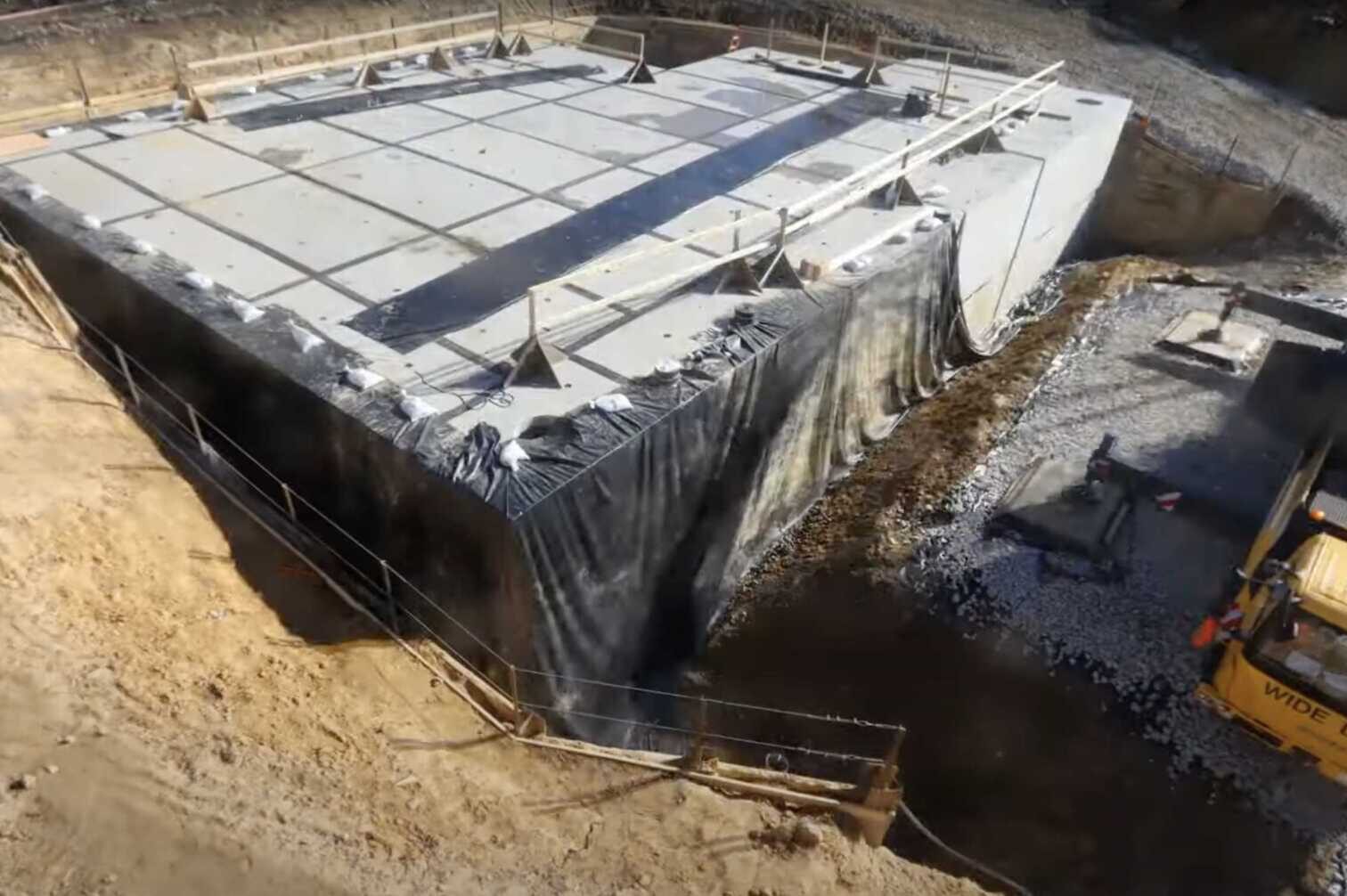
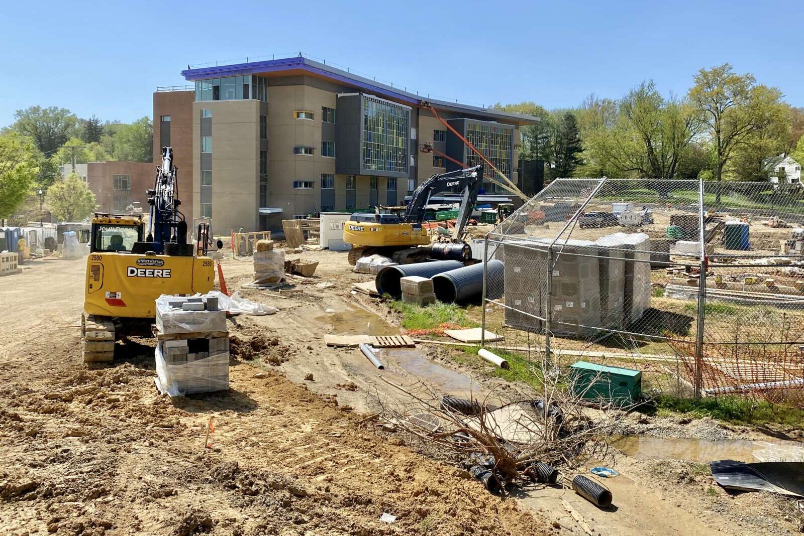
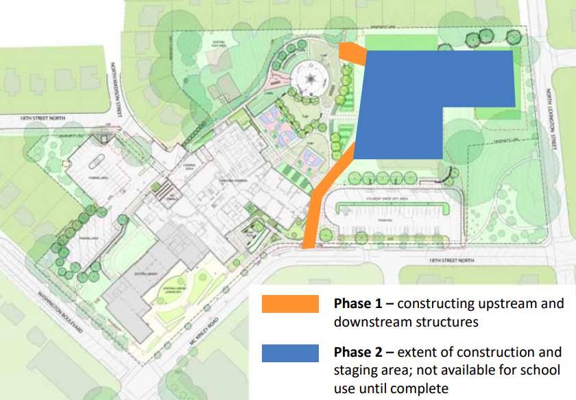
Arlington County will mark the completion of the vault with a ribbon-cutting this Saturday during a neighborhood festival at the school, dubbed Westover Day. Beyond celebrating the completed vault, Westover Day will also mark the completion of the new school building, athletic field and playground with school tours, live music and food trucks.
The 47,000-square-foot vault is part of the county’s strategy, dubbed Flood Resilient Arlington, to mitigate the major impacts of flooding. Located in the Torreyson Run watershed, Westover is one of the communities being prioritized for stormwater upgrades.
The vault is designed to hold just over 4 million gallons of stormwater — “equal to six Olympic swimming pools,” according to the county. Its construction, a joint effort by Arlington County and Arlington Public Schools, took two years and was separated into two phases.
First, underground pipes and junction boxes were installed to divert water from an existing storm sewer beneath the school property to where the newly built vault would be, according to the county website. Then, in December 2021, construction of the vault began. It was substantially completed this June.
A video below shows a timelapse of construction through last December.
The athletic fields atop the stormwater vault were closed for sodding but the county tells ARLnow the work is now complete and the fields open.
The ribbon-cutting for the vault at Cardinal Elementary comes on the heels of another county stormwater improvement project.
On Tuesday, county officials celebrated the transformation of the once sludge-filled Ballston Wetland Park into a more robust stormwater filtration system and wildlife refuge.

")
")
")

")
")

")
")