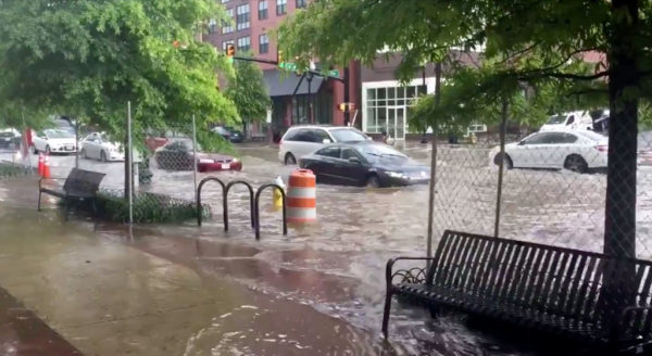
The video (below) was jarring: cars driving through muddy flood waters that nearly reached the tops of tires.

Even more jarring: this was happening along busy Columbia Pike, a route not noted for being flood-prone, during the evening rush hour.

The scene yesterday evening was captured on video by a passerby, showing floodwaters inundating a low-lying section of the Pike near S. Greenbrier Street. As commenters pointed out this morning, driving through flooded roads is a bad idea, but despite repeated reminders to “turn around, don’t drown,” drivers continue willfully operating their vehicles as if they were hovercraft.

(A spokesman with Arlington’s Dept. of Environmental Services tells ARLnow the department is still investigating the flooding and “looking into whether there were any construction-related obstructions in the storm sewer inlets.”)

Arlington County Police Department spokeswoman Ashley Savage this morning offered the following tips for driving during heavy rain and potential flooding situations.

Residents are reminded to:

  • Sign up for Arlington Alert to receive emergency notifications including severe weather alerts.
  • Whenever possible, limit travel during times of severe weather.
  • Avoid areas already flooded, especially if the water is flowing fast.
  • It is never safe to drive or walk into flood waters. If you see a flooded roadway, seek an alternative route.
  • According to the National Weather Service, 6 inches of fast-moving flood water can knock over an adult. It takes just 12 inches of rushing water to carry away a small car, while 2 feet of rushing water can carry away most vehicles. Play it safe, Turn Around Don’t Drown.
  • If you see a hazard, report to the Emergency Communications Center at 703-558-2222 or call 9-1-1 in an emergency.

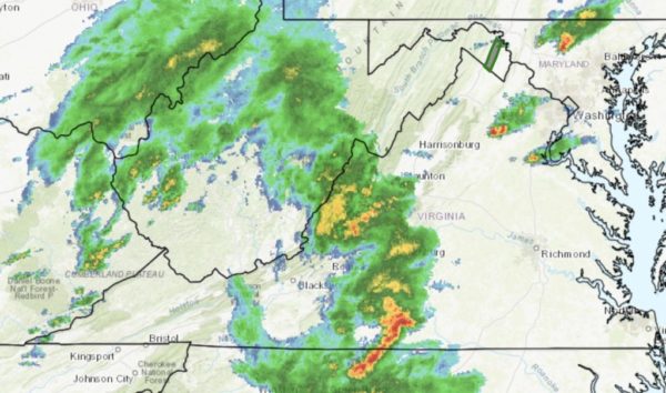
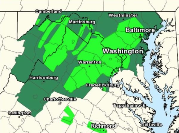
Those tips may come in handy tonight. A Flash Flood Watch is set to take effect at 2 p.m. From the National Weather Service:

…FLASH FLOOD WATCH REMAINS IN EFFECT UNTIL 11 PM EDT THIS EVENING… * THUNDERSTORMS WITH HEAVY RAINFALL ARE EXPECTED TO DEVELOP ACROSS THE WATCH AREA THIS AFTERNOON AND LINGER INTO THE EVENING. LOCALIZED RAINFALL TOTALS OF SEVERAL INCHES ARE POSSIBLE. THIS COULD LEAD TO FLASH FLOODING, ESPECIALLY IN THE URBAN AREAS. PRECAUTIONARY/PREPAREDNESS ACTIONS… A FLASH FLOOD WATCH MEANS THAT CONDITIONS MAY DEVELOP THAT LEAD TO FLASH FLOODING. FLASH FLOODING IS A VERY DANGEROUS SITUATION. YOU SHOULD MONITOR LATER FORECASTS AND BE PREPARED TO TAKE ACTION SHOULD FLASH FLOOD WARNINGS BE ISSUED. &&

The video from last night’s flooding is below.

Photo via Becky Haberacker/Twitter
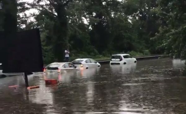

Columbia Pike Flooding — Columbia Pike flooded near S. Greenbrier Street during last night’s storms. Drivers could be seen driving through standing water as high as the tops of car tires. [Twitter]

Another Flash Flood Watch — Arlington is again under a Flash Flood Watch from 2-11 p.m. today, as slow-moving storms may produce torrential, flooding rainfalls. [Weather.gov, Twitter]

County to Tackle Premature Tree Deaths — “‘The county is not taking adequate care of its newly planted trees,’ said [Elizabeth] Grossman, a member of the Arlington Tree Action Group, who said that while there were many reasons trees may not survive after being planted, the death rate on Arlington government property seems excessive.” [InsideNova]

Fire at Ballston Building — “Firefighters are on scene of a fire at a high-rise residential building on the 800 block of N. Quincy Street in Ballston. Reportedly a small fire in one of the units.” [Twitter, Twitter]

One Reason Arlington Landed HQ2 — “A West Coast economist’s ideas challenge the ‘world is flat’ conventional wisdom about tech jobs. They’re a major part of the reason Arlington landed Amazon.” [Washingtonian, Twitter]

Retiring Superintendent Has a New Gig — Last week, Arlington Public Schools Superintendent Dr. Patrick K. Murphy told the School Board he would be retiring in September. On Sept. 1, he will begin his new job as superintendent of Berkeley County Schools in West Virginia. [Berkeley County Schools]


Update at 4:25 p.m. — A Severe Thunderstorm Watch has been issued for Arlington through 11 p.m.

Update at 1:15 p.m. — The Flash Flood Watch for Arlington has been cancelled, but storms are still expected later today, according to the National Weather Service.

Earlier: Arlington County and surrounding areas are under a Flash Flood Watch starting at 2 p.m. today.

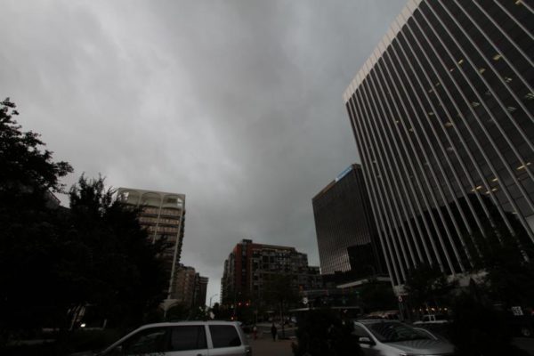
Forecasters say heavy rain and storms are expected this afternoon and evening, creating the potential for flash flooding.

More from the National Weather Service:

…FLASH FLOOD WATCH IN EFFECT FROM 2 PM EDT THIS AFTERNOON THROUGH THIS EVENING… NUMEROUS TO WIDESPREAD SHOWERS AND THUNDERSTORMS ARE EXPECTED THIS AFTERNOON AND THIS EVENING IN A VERY WARM AND HUMID ENVIRONMENT. THERE IS POTENTIAL FOR SHOWERS TO MOVE REPEATEDLY OVER THE SAME AREAS AND TO PRODUCE INTENSE RAINFALL RATES IN A SHORT PERIOD OF TIME THAT MAY LEAD TO FLASH FLOODING. THE GREATEST RISK OF FLASH FLOODING IS ACROSS NORTHERN AND CENTRAL MARYLAND. PRECAUTIONARY/PREPAREDNESS ACTIONS… A FLASH FLOOD WATCH MEANS THAT CONDITIONS MAY DEVELOP THAT LEAD TO FLASH FLOODING. FLASH FLOODING IS A VERY DANGEROUS SITUATION. YOU SHOULD MONITOR LATER FORECASTS AND BE PREPARED TO TAKE ACTION SHOULD FLASH FLOOD WARNINGS BE ISSUED. &&

File photo


Arlington County and much of the D.C. region is now under a Flash Flood Watch.

The watch is in effect until 10 a.m. Sunday. Forecasters say multiple rounds of heavy rain and storms could produce flash flooding.

More from the National Weather Service:

…FLASH FLOOD WATCH REMAINS IN EFFECT FROM 8 PM EDT THIS EVENING THROUGH SUNDAY MORNING… WIDESPREAD SHOWERS AND POSSIBLE THUNDERSTORMS WILL DEVELOP THIS EVENING AND CONTINUE INTO SUNDAY MORNING. LOCALLY HEAVY RAINFALL IS EXPECTED. AVERAGE RAINFALL AMOUNTS WILL BE BETWEEN 1 AND 3 INCHES WITH LOCALLY HIGHER AMOUNTS AROUND 4 INCHES POSSIBLE. * HEAVY RAINFALL IN SHORT PERIODS OF TIME MAY CAUSE CREEKS AND STREAMS TO RAPIDLY RISE OUT OF THEIR BANKS ALONG WITH THE POTENTIAL FOR FLASH FLOODING IN URBAN AREAS. PRECAUTIONARY/PREPAREDNESS ACTIONS… A FLASH FLOOD WATCH MEANS THAT CONDITIONS MAY DEVELOP THAT LEAD TO FLASH FLOODING. FLASH FLOODING IS A VERY DANGEROUS SITUATION. YOU SHOULD MONITOR LATER FORECASTS AND BE PREPARED TO TAKE ACTION SHOULD FLASH FLOOD WARNINGS BE ISSUED. &&


(Updated at 1:25 p.m.) Arlington and the D.C. region is now under a Tornado Watch.

The watch is in effect until midnight tonight. Forecasters say the storms approaching the area may spawn isolated tornadoes.

The region is also under a Flash Flood Watch, with heavy rain expected this afternoon and evening. The expected stormy weather has prompted airlines to allow travelers at Reagan National Airport to change their flights without additional fees.

More from the National Weather Service:

MULTIPLE ROUNDS OF SHOWERS AND THUNDERSTORMS ARE EXPECTED THIS AFTERNOON AND EVENING. SOME OF THE STORMS WILL LIKELY BE CAPABLE OF PRODUCING DAMAGING WIND GUSTS AND ISOLATED TORNADOES.

A FLASH FLOOD WATCH IS IN EFFECT FROM NOON TODAY THROUGH MOST OF TONIGHT FOR THE ENTIRE OUTLOOK AREA.

GALE CONDITIONS ARE POSSIBLE OVER THE WATERS TONIGHT.

With flooding and power outages possible, Arlington County Police are reminding motorists to take extra precautions on the roads.


Flash Flood Watch Issued — Arlington and the region is under a Flash Flood Watch starting at noon today. Heavy rain and storms, some of which may be severe, are expected this afternoon and evening. [Twitter, Twitter]

Anytime Fitness Opening TodayAnytime Fitness, a new 24/7 gym, is set to open today in Rosslyn. “New member specials will be available through the end of April and free community workouts will be held every Saturday in May,” said a PR rep.

Protest Yesterday in Ballston — “A protest against power company AES is happening this morning in Ballston outside the company’s HQ. ACPD is on the scene watching over the protest, which is peaceful and includes speeches and signs against AES’ activities in Puerto Rico.” [Twitter]

Bike Recycling Event Next Month — “Bikes for the World will be collecting unneeded bicycles, bike parts and accessories on Saturday, May 4 from 8:30 a.m. to 3 p.m. as part of the Arlington E-CARE (Environmental Collection and Recycling Event) at 1425 North Quincy St.” [InsideNova]

Carbeque on I-395 — A car caught fire on southbound I-395 near Glebe Road just before Thursday’s evening rush hour. Several lanes were closed as a result of the vehicular inferno, but firefighters eventually extinguished the raging flames. No injuries were reported. [Twitter]

Good Friday in Arlington — “On Friday, April 19, several parishes of the Catholic Diocese of Arlington will offer Living Stations of the Cross (or Via Crucis en Vivo). The Living Stations consist of a visual portrayal of Jesus on the way to his crucifixion.” [Diocese of Arlington]

Photo courtesy Dennis Dimick


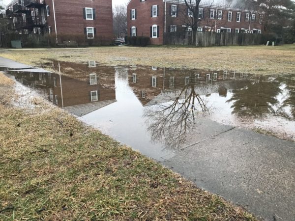
The groundwater level in Arlington is rising, officials say, which could cause more flooded homes and mosquito-filled backyards.

Arlington’s Dept. of Environmental Services says current groundwater levels are an average of 5 feet higher than they were during the past two years. Officials say one reason is last year’s 60-inch rainfall, which broke the 1889 record for the region’s rainiest year ever recorded.

“The potential for flooding, especially localized flooding, is affected with the ground being more saturated,” said DES’s Stormwater Outreach Specialist Lily Whitesell.

Whitesell explained that the “void” in soil which usually absorbs water is now filled with water. This mean water can’t be as easily absorbed and it’s more likely to cause runoff and flooding.

The likelihood of flooding will be highest when storms dump an inch or more of rain on the area, she said.

In addition to floods, Whitesell said residents can also expect:

  • Softer, muddier ground in general
  • More mosquitos as water “ponds” in backyards,
  • Algae potentially growing on sidewalks and in gutters
  • More sump pump discharge
  • Plants that prefer drier weather to suffer

“Water ponding next to your foundation is not something that you want for the long-term structural safety of a home,” said Whitesell. “And certainly if you have a basement nobody wants water getting in there.”

She clarified that rising groundwater levels do not affect floodplain boundaries, which are drawn based on severe, “100-year” floods. However, the DES website notes that county waterways can be hit hard by stormwater runoff which causes:

  • Erosion: The high volume of water erodes stream banks, compromising trails and trees along our stream valley parks.
  • Pollutants: Stormwater washes pollutants like nutrients (nitrogen and phosphorus), sediment, bacteria, petroleum, pet waste and trash into our streams, causing poor water quality.
  • Temperature: During the summer months, stormwater heats up as it flows over hot pavement, which then increases the temperature of the stream water by as much as 10 degrees Fahrenheit, causing stress or death to aquatic organisms.

Rising groundwater levels can also affect the underground vaults that protect controls for utilities like electricity, gas and telephone lines, Whitesell said. When these gather moisture or flood it can pose a risk to equipment and workers as NIOSH has reported.

“Some vaults are very shallow and so may not be affected,” said Whitesell. “But some are deep enough to be affected.”

When asked, Whitesell said the swell of rainstorms could be a symptom of climate change: “One of the effects we expect with global warming and climate change is that wet areas get wetter and dry areas get drier.”

In Arlington, Whitesell said the number of applications to the county’s Stormwater Wise Program that helps homeowners reduce stormwater run-off has doubled over the last year.

“We’re all hoping for a drier year,” she said.

In the meantime, DES recommends residents flood-proof their homes as much as possible and check whether they’re eligible for flood insurance. But in case all else fails the department suggests residents take the following precautions:

  • Know how to shut off the electricity and gas to your house, in the event of flooding.
  • Make a list of emergency numbers and identify a safe place to go.
  • Make a household inventory of belongings, especially the contents in the basement.
  • Keep important documents and medicine in a water proof container in a safe place.
  • Gather supplies in case you have to leave immediately, or if services are cut off — medications, pet supplies, batteries.
  • If your home needs a sump pump, get a battery backup in case the power goes out. Check on the pump regularly, especially if it’s more than eight years old.
  • Read more tips for Preparing for Storms.

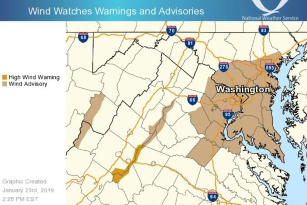
Arlington County and surrounding areas are under both a Flood Watch and a Wind Advisory Thursday, as a front brings heavy rain and strong winds to the region.

About 1-2 inches of rain is expected to fall, potentially causing flooding in low-lying areas and along streams and creeks.

More from the National Weather Service:

…FLOOD WATCH REMAINS IN EFFECT… * FROM LATE TONIGHT THROUGH THURSDAY AFTERNOON * RAIN WILL OVERSPREAD THE AREA THIS EVENING AND OVERNIGHT. THE HEAVIEST RAIN IS EXPECTED OVERNIGHT AND THURSDAY MORNING. TOTAL RAINFALL AMOUNTS AROUND 1 INCH ARE EXPECTED, WITH ISOLATED HIGHER AMOUNTS OF 1.5 TO 2 INCHES POSSIBLE. * EXCESS RUNOFF FROM A NEARLY FROZEN GROUND AND SATURATED SOILS WILL CAUSE THE POTENTIAL FOR STREAMS AND CREEKS TO RISE OUT OF THEIR BANKS AS WELL AS POTENTIAL FLOODING IN LOW LYING URBAN AREAS. PRECAUTIONARY/PREPAREDNESS ACTIONS… A FLOOD WATCH MEANS THERE IS A POTENTIAL FOR FLOODING BASED ON CURRENT FORECASTS. YOU SHOULD MONITOR LATER FORECASTS AND BE ALERT FOR POSSIBLE FLOOD WARNINGS. THOSE LIVING IN AREAS PRONE TO FLOODING SHOULD BE PREPARED TO TAKE ACTION SHOULD FLOODING DEVELOP. &&

In addition to the rain, damaging winds are possible.

…WIND ADVISORY IN EFFECT FROM 6 AM TO NOON EST THURSDAY… THE NATIONAL WEATHER SERVICE IN BALTIMORE MD/WASHINGTON HAS ISSUED A WIND ADVISORY, WHICH IS IN EFFECT FROM 6 AM TO NOON EST THURSDAY. * TIMING…THURSDAY MORNING. * WINDS…SOUTHWEST 20 TO 30 MPH WITH GUSTS UP TO 50 MPH. * IMPACTS…GUSTY WINDS WILL BLOW AROUND UNSECURED OBJECTS. TREE LIMBS COULD BE BLOWN DOWN AND A FEW POWER OUTAGES MAY RESULT. PRECAUTIONARY/PREPAREDNESS ACTIONS… A WIND ADVISORY MEANS THAT WINDS OF 45 TO 55 MPH ARE EXPECTED. WINDS THIS STRONG CAN MAKE DRIVING DIFFICULT, ESPECIALLY FOR HIGH PROFILE VEHICLES. &&

More via social media:

Photo (top) via National Weather Service


Flood Watch in Effect — Expect periods of rain today. The National Weather Service has issued a Flood Watch for much of the region through late tonight. “Excessive runoff from already saturated soils will cause the potential for streams and creeks to rise out of their banks as well as flooding in low lying urban areas,” forecasters say. [Weather.gov, Twitter]

Arlington Doesn’t Want to Pick Fight Over J-D Hwy — “The Arlington County government’s efforts to rename its portion of Jefferson Davis Highway could face familiar legislative roadblocks in 2019. But County Board members say they have no interest in forcing a confrontation with the General Assembly on the matter.” [InsideNova]

New Year’s Meeting Scheduled for Jan. 2 — Next week, what used to be a New Year’s Day organizational meeting for the Arlington County Board will again be held on Jan. 2 instead. The Board will elect a new Chair and Vice Chair at the meeting. [Arlington County]

Developer Buys Wilson Blvd Property — “The Meridian Group has picked up its next value-add Arlington County office building as it… closed Wednesday on its acquisition of 2500 Wilson Blvd. and several adjacent parcels from an affiliate of TH Real Estate for a consideration amount of nearly $39 million, or roughly $373 per square foot, according to Arlington County land records.” [Washington Business Journal]

Dulles Toll Road Rates Rising — “Starting Jan. 1, prices are scheduled to go up for those driving on the Dulles Toll Road. The cost to passenger vehicles will increase from $2.50 to $3.25 at the main toll plaza and from $1 to $1.50 on ramps.” [Tysons Reporter]


The Arlington County Fire Department is urging residents to “turn around, don’t drown” when encountering a flooded roadway.

A Flood Warning is in effect for Arlington County until 1:30 a.m. as rain continues to fall. More from the National Weather Service:

…A FLOOD WARNING REMAINS IN EFFECT UNTIL 130 AM EST FOR THE DISTRICT OF COLUMBIA…MONTGOMERY…CENTRAL PRINCE GEORGES… NORTHEASTERN LOUDOUN…ARLINGTON…AND NORTHEASTERN FAIRFAX COUNTIES…THE CITY OF FALLS CHURCH AND THE CITY OF ALEXANDRIA… AT 735 PM EST, EMERGENCY MANAGEMENT AND TRANSPORTATION OFFICIALS REPORTED AREAS OF FLOODING ACROSS THE AREA. BRIGHTON DAM ROAD NEAR THE HOWARD COUNTY/MONTGOMERY COUNTY LINE WITHIN THE PATUXENT RIVER WATERSHED HAS WATER FLOWING ACROSS THE ROADWAY, NECESSITATING A WATER RESCUE. ADDITIONAL CLOSED ROADS ARE BEING REPORTED IN GLENN DALE IN PRINCE GEORGE’S COUNTY MD, AND NEAR PHILOMONT ALONG LIME KILN ROAD IN LOUDOUN COUNTY VA. MOTORISTS USING ROCK CREEK PARKWAY FROM SOUTHERN MONTGOMERY COUNTY INTO NORTHWEST DC SHOULD BE PREPARED FOR FLOODED ROADWAYS. AT 7:15 PM EST, THE GAUGE AT SHERRILL DRIVE ON ROCK CREEK IN NW DC IS WITHIN ONE-HALF FOOT OF FLOOD STAGE, AND IS CONTINUING TO RISE WITH MORE RAIN ON THE WAY OVER THE NEXT FEW HOURS. IT IS EXPECTED FOR ROCK CREEK TO REACH FLOOD STAGE BY 9:00 PM EST. RAIN WILL CONTINUE TO PERSIST THROUGH THE EVENING HOURS, ESPECIALLY IN MONTGOMERY COUNTY, WHERE WE ARE ALREADY SEEING FLOODING. PRECAUTIONARY/PREPAREDNESS ACTIONS… TURN AROUND, DON’T DROWN WHEN ENCOUNTERING FLOODED ROADS. MOST FLOOD DEATHS OCCUR IN VEHICLES. BE ESPECIALLY CAUTIOUS AT NIGHT WHEN IT IS HARDER TO RECOGNIZE THE DANGERS OF FLOODING. IF LAW ENFORCEMENT HAS PUT UP BARRICADES ON FLOODED ROADWAYS, DO NOT GO AROUND THE BARRICADES, THINKING YOUR VEHICLE CAN GET THROUGH THE FLOOD WATERS. &&

Numerous flooded roadways and water rescues have been reported in nearby Fairfax County. Arlington County has seen fewer significant problems, but ponding has been reported on some local roads.

Today’s rain helped to make 2018 the wettest year on record for the D.C. area. More showers and drizzle are expected Sunday.


A Flood Watch will be in effect starting at 6 p.m. tonight as Arlington and the D.C. area is in for a heavy dose of rain through Saturday evening.

The National Weather Service says 1-2 inches of rain is likely, raising the possibility of flooding along creeks, streams and in urban areas.

More from NWS:

…FLOOD WATCH REMAINS IN EFFECT FROM THIS EVENING THROUGH
SATURDAY AFTERNOON…


* From this evening through Saturday afternoon

* Moderate rainfall is expected with locally heavy rain possible. Rainfall amounts around 1 to 2 inches are most likely with locally higher amounts around 3 inches possible. Runoff from the rainfall may cause creeks and streams to rise out of their banks as well as the potential for flooding in urban areas.

PRECAUTIONARY/PREPAREDNESS ACTIONS…

A Flood Watch means there is a potential for flooding based on current forecasts.

You should monitor later forecasts and be alert for possible Flood Warnings. Those living in areas prone to flooding should be prepared to take action should flooding develop.


View More Stories