A rainy night and morning are on tap for Arlington, leading the National Weather Service to issue a Flash Flood Watch.

D.C., Alexandria and points north and west are also included in the watch.

More from NWS:

146 PM EDT WED SEP 22 2021

…FLASH FLOOD WATCH IN EFFECT FROM LATE TONIGHT THROUGH THURSDAY AFTERNOON…

THE NATIONAL WEATHER SERVICE IN STERLING VIRGINIA HAS EXPANDED THE

* FLASH FLOOD WATCH TO INCLUDE PORTIONS OF DC, MARYLAND AND NORTHERN VIRGINIA, INCLUDING THE FOLLOWING AREAS: IN DC, DISTRICT OF COLUMBIA. IN MARYLAND, CARROLL, CECIL, CENTRAL AND SOUTHEAST HOWARD, CENTRAL AND SOUTHEAST MONTGOMERY, NORTHERN BALTIMORE, NORTHWEST HARFORD, NORTHWEST HOWARD, NORTHWEST MONTGOMERY, SOUTHEAST HARFORD AND SOUTHERN BALTIMORE. IN NORTHERN VIRGINIA, ARLINGTON/FALLS CHURCH/ALEXANDRIA, EASTERN LOUDOUN AND FAIRFAX.

* FROM LATE TONIGHT THROUGH THURSDAY AFTERNOON.

* MULTIPLE ROUNDS OF SHOWERS AND SCATTERED THUNDERSTORMS CAPABLE OF PRODUCING HEAVY RAIN ARE EXPECTED THROUGH THURSDAY AFTERNOON. THE MOST WIDESPREAD HEAVY RAIN IS MOST LIKELY LATE TONIGHT THROUGH EARLY THURSDAY AFTERNOON. AVERAGE RAINFALL AMOUNTS OF 1 TO 2 INCHES ARE EXPECTED, WITH LOCALIZED HIGHER AMOUNTS OF UP TO 4 INCHES POSSIBLE. HEAVY RAIN FALLING OVER INCREASINGLY SATURATED GROUND MAY RESULT IN FLASH FLOODING.

PRECAUTIONARY/PREPAREDNESS ACTIONS…

YOU SHOULD MONITOR LATER FORECASTS AND BE PREPARED TO TAKE ACTION SHOULD FLASH FLOOD WARNINGS BE ISSUED.

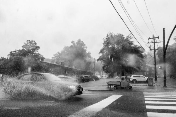
File photo


Board OKs More Small Biz Money — “The Arlington County Board voted 5-0 today to approve the Small Business GRANT 2.0 program, which will provide direct financial assistance to small businesses as they continue to recover from the devastating impacts of the COVID-19 pandemic.  The GRANT 2.0 program will provide immediate funds to businesses and nonprofits to aid in their short-term recovery.” [Arlington County]

Amazon Ramps Up HQ2 Hiring — “That job posting is one of roughly 2,700 openings newly unveiled by Amazon for its HQ2 campus, 99% of which are full-time corporate roles. The slew of new openings was added to the company’s jobs site earlier this week, ahead of Wednesday’s annual Amazon Career Day, held virtually… This is one of the bigger hiring pushes by the tech giant, which disclosed this month that its latest HQ2 employee tally tops 3,000, nearly double its last count in December.” [Washington Business Journal]

Amazon Charts Path to Net Zero Carbon — “Amazon.com Inc.’s design for the second phase of its HQ2 development must be carbon-neutral to comply with both Arlington County’s policy, as well as the tech giant’s own climate pledge to reach that status by 2040… The company’s consultant, Seattle-based Paladino and Co. Inc., found that carbon neutrality is “likely feasible” based on the current PenPlace [HQ2] design.” [Washington Business Journal]

Another Video of Columbia Pike Flooding — “We needed some scuba gear out on Columbia Pike” during Thursday’s flash flooding near S. Greenbrier Street. [Twitter]

Lots of Locals Want to Work at the Polls — “Arlington has too many people wanting to serve as poll officials in the upcoming election. Way, way too many. About 440 are needed and more than 1,100 expressed interest in serving, said Eric Olsen, Arlington’s deputy registrar. He called it, without hyperbole, ‘an extraordinary amount of interest.'” [Sun Gazette]

Remembering the Alexandria Canal — “The canal was completed in 1843. It roughly followed today’s Metro blue line and South Eads Street in Crystal City. Canal shipping, though interrupted by the Civil War, continued until 1886, by which time, railroads had rendered it obsolete. In modern times, remnants of the Aqueduct Bridge are visible from both the Virginia and Georgetown sides of the Potomac.” [Falls Church News-Press]


A group of Marines in their dress blue uniforms braved floodwaters along Columbia Pike to help a stranded motorist.

Video of the rescue has gone viral on TikTok, racking up more than 800,000 views as of this article’s publication. It appears to have taken place on Columbia Pike near the Pentagon on Thursday, amid a torrential downpour that flooded a number of roadways around Arlington.

The Marines, in their formal white pants and blue jackets, are seen getting out of a Marine Corps bus that’s stopped on the side of Columbia Pike, under a bridge carrying traffic on Washington Blvd. High standing water can be seen around the driver’s car.

“The Marines are going to help us?” she’s heard asking. “We just got stuck.”

The group trudges through the floodwaters and then is seen pushing the car to safety.

“Oh my God, this is the most American thing ever,” the driver says. “Thank you so much!”

In the comments on TikTok, the driver further expressed her gratitude.

“As an immigrant we don’t usually see these thing in the country I grew up in,” she wrote. “I am so grateful for the country and its Marines and military.”

It’s all in a day’s work for members of the Corps, said others in the comments.

“I am going to tell you right now, they LOVED helping you out,” one man wrote. “Cause this is what we Marines do.”

@vigi.boo

#themarines #unitedstatesofamerica #greateful #semperfi #thedaythemarineshelpedus #godblessamerica #usamarines #amen #beautiful #intimesofstress #hope

♬ People Help the People – Birdy

Hat tip to @theblueapple


A deer and a fox in the rain, near the Arlington-Fairfax border (photo courtesy Marc Roth)

‘Kindness Yard Sale’ in Penrose — “Susan Thompson-Gaines wants to spread kindness. This weekend, she’s doing it through a big yard sale at her house. She says it’s hard to miss the home she shares with her husband, David — it’s the yellow house with purple trim at the corner of South Second and South Fillmore streets in Arlington… what makes this yard sale different is that the proceeds are all spent on acts of kindness.” [WTOP]

Flood Cleanup for Pike Businesses — From WUSA 9’s Matthew Torres: “A dental hygienist sent me this other video of the flash flooding in Columbia Pike in Arlington. Their business had to close today as they clean up the water that seeped through. Other businesses are having to do the same thing.” [Twitter]

More Vaccinations Added to State Stats — “Today, the Virginia Department of Health (VDH) has incorporated vaccination data from jurisdictions in Maryland. Virginians who received vaccinations in Maryland that were not reported through the Virginia Immunization Information System are now included in the locality and statewide dashboards. The updated data reflects an increase in COVID-19 vaccine first dose rates of 0.33% Alexandria, 0.46% Arlington, and 0.39% Eastern Shore.” [Virginia Dept. of Health]

AFAC Gets Donation from Library Program –“Representatives of the Friends of the Arlington Public Library (FOAL), together with the Arlington Public Library and Arlington County Department of Technology Services, presented a check for $4,525 to the Arlington Food Assistance Center (AFAC). The donation represents the number of Library readers who successfully completed the 2021 Summer Reading Challenge. The Library’s popular Summer Reading program helps children avoid the ‘summer slide.'” [Arlington County]

Fmr. County Board Member Dies — “Jay Edwin Ricks, 88, passed away at home in Arlington, Virginia on July 18, 2021 due to complications of Parkinson’s Disease… In 1967, Jay was elected to the Arlington County Board where he served until 1971. During this time, he was active in transportation issues and Vice Chairman of Metro during the critical phase of planning the Metro system.” [Legacy]

Local Church Adapts to Pandemic — ‘As another wave of the pandemic comes at us, we are different as a congregation,’ said the Rev. Amanda Poppei, senior minister at the Unitarian Universalist Church of Arlington, Virginia… Poppei’s congregation began hosting outdoor events in spring 2021, including a handbell parade to ring in Pride Month in June and a Flower Communion in May, which they intentionally designed as a multiplatform event.” [UUWorld]


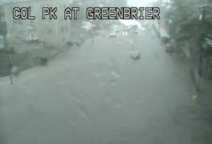
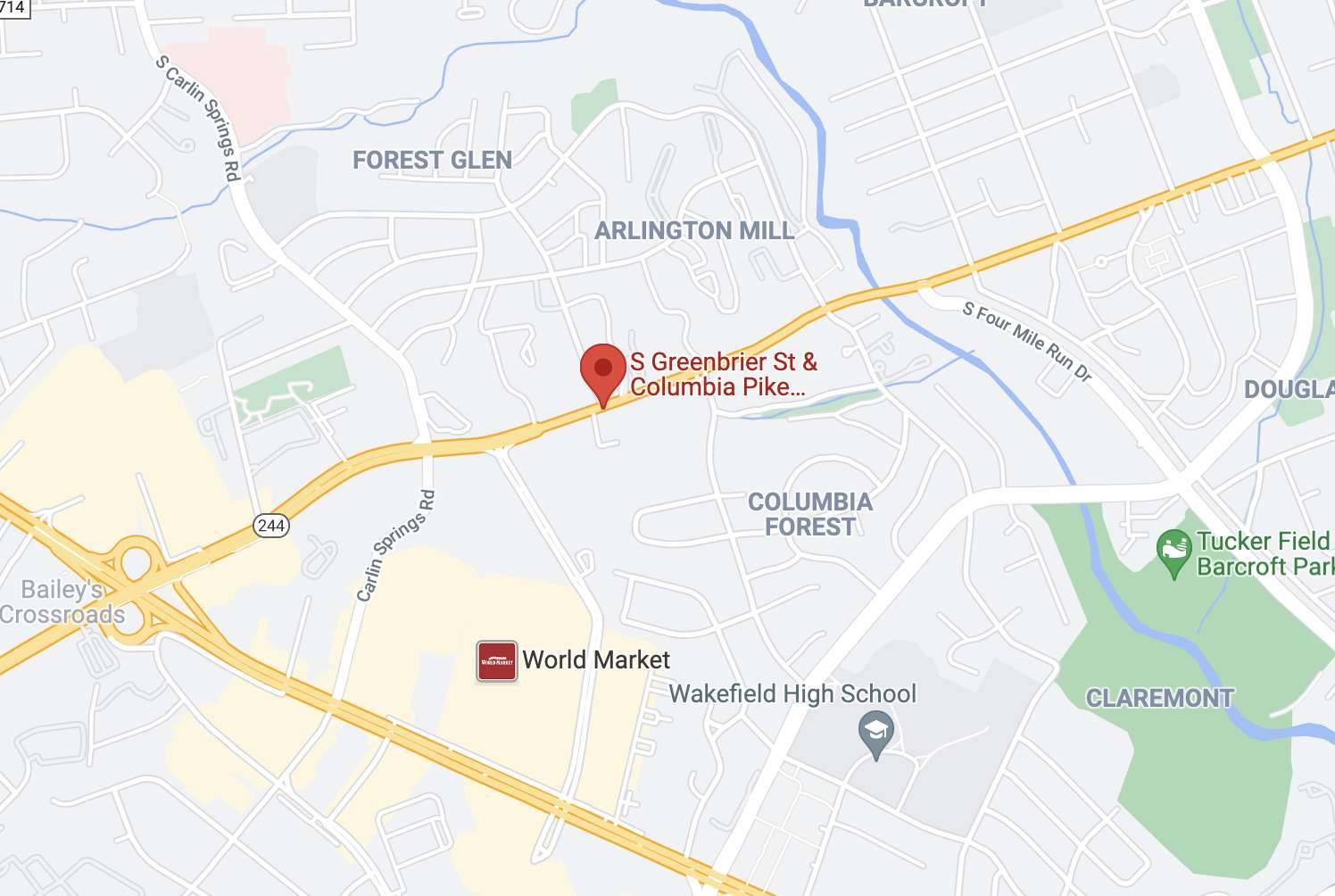
(Updated at 4:50 p.m.) Floodwaters have receded after Columbia Pike was blocked at S. Greenbrier Street around 3:30 this afternoon.

At least one car was stuck in the high water, near the 55 Hundred apartments, just west of the county line, prompting a water rescue operation. Other traffic could be seen turning around.

Firefighters successfully rescued the driver of the vehicle that was stuck, according to scanner traffic.

https://twitter.com/News_MTorres/status/1438602239594094593

Reports of flooding came as the National Weather Service issued a new Flood Warning for the county. Just before 4 p.m., a Flash Flood Warning was also issued.

From NWS:

THE NATIONAL WEATHER SERVICE IN STERLING VIRGINIA HAS ISSUED A

* FLOOD WARNING…

* UNTIL 930 PM EDT THURSDAY.

* AT 321 PM EDT, DOPPLER RADAR INDICATED HEAVY RAIN DUE TO THUNDERSTORMS. FLOODING IS ONGOING OR EXPECTED TO BEGIN SHORTLY IN THE WARNED AREA. BETWEEN 1 AND 1.5 INCHES OF RAIN HAVE FALLEN.

* SOME LOCATIONS THAT WILL EXPERIENCE FLOODING INCLUDE… ARLINGTON… ALEXANDRIA… BETHESDA… RESTON… ANNANDALE… SPRINGFIELD… FORT WASHINGTON… FAIRFAX… LANGLEY PARK… FORT HUNT… VIENNA… GROVETON… FALLS CHURCH… HUNTINGTON… CORAL HILLS… BLADENSBURG… MANTUA… PIMMIT HILLS… NATIONAL HARBOR… ROSSLYN…

ADDITIONAL RAINFALL AMOUNTS OF 1 TO 2 INCHES ARE POSSIBLE IN THE WARNED AREA.

PRECAUTIONARY/PREPAREDNESS ACTIONS…

TURN AROUND, DON’T DROWN WHEN ENCOUNTERING FLOODED ROADS. MOST FLOOD DEATHS OCCUR IN VEHICLES.

In addition to the Pike flooding, high standing water was reported along I-395.

Previously, NWS issued a Flash Flood Watch for the area, effective until 9 p.m.

The rain has already cancelled at least one local event, a pop-up jazz performance in Rosslyn.


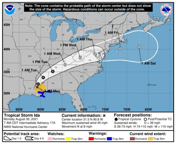
Expected track of the remnants of Hurricane Ida (via National Weather Service)

(Updated at noon) The remnants of Hurricane Ida are heading our way, and forecasters are already warning of potential flooding.

Ida has ravaged portions of Louisiana and Mississippi since making landfall as a Category 4 storm Sunday afternoon. It knocked out power to more than a million homes and businesses, including the entire city of New Orleans; interrupted 911 service; and caused catastrophic flooding, prompting numerous water rescues.

Now a tropical storm, Ida is on a northeasterly track that is expected to put its remnants squarely over the D.C. area starting Wednesday.

Two days ahead of Ida’s arrival, the National Weather Service this morning issued a Flash Flood Watch, to take effect from 11 a.m. Wednesday to 8 a.m. Thursday. Some 2-5 inches of rain could fall during that time.

Forecasters are also warning of the potential for severe weather or even tornadoes spawned by Ida.

“Heavy tropical rainfall could result in considerable flash flooding,” NWS wrote. “A few severe thunderstorms are possible Wednesday into Wednesday night. Damaging wind gusts and a brief tornado are the main threats.”

More from NWS:

…FLASH FLOOD WATCH IN EFFECT FROM WEDNESDAY MORNING THROUGH THURSDAY MORNING…

The National Weather Service in Sterling Virginia has issued a

* Flash Flood Watch for portions of DC, Maryland and Virginia…

* From Wednesday morning through Thursday morning.

* The remnants of Ida will interact with a stalled front, resulting in a prolonged period of heavy rainfall beginning Wednesday morning and continuing through Wednesday night. Rainfall amounts of 2 to 4 inches are expected, with localized amounts up to 6 inches possible.

* This amount of heavy rainfall will not only result in the potential for considerable flash flooding of creeks, small streams, and urban areas, but also the potential for river flooding on the main stem rivers.

PRECAUTIONARY/PREPAREDNESS ACTIONS…

You should monitor later forecasts and be prepared to take action should Flash Flood Warnings be issued.

Strong storms are also possible tonight (Monday), with the arrival of a cold front that will end our stretch of sweltering weather and temperatures in the 90s.

“Isolated damaging wind gusts are possible this afternoon and evening,” NWS wrote. “An isolated instance of flooding is also possible.”

Just before noon, a Flash Flood Watch was issued for Monday afternoon.

1148 AM EDT Mon Aug 30 2021

…FLASH FLOOD WATCH IN EFFECT UNTIL 10 PM EDT THIS EVENING…
…FLASH FLOOD WATCH REMAINS IN EFFECT FROM WEDNESDAY MORNING
THROUGH THURSDAY MORNING…

The National Weather Service in Sterling Virginia has issued a

* Flash Flood Watch for portions of DC, Maryland and Virginia…

* Until 10 PM EDT this evening.

* Scattered to numerous showers and thunderstorms are likely this afternoon and evening, some of which may produce a few inches of rain in a short period of time.

* Heavy rainfall in a short period of time would result in rapid rises of water in small streams and creeks, and in urban and poor drainage areas.

PRECAUTIONARY/PREPAREDNESS ACTIONS…

You should monitor later forecasts and be prepared to take action should Flash Flood Warnings be issued.


Local Real Estate Market Slowing — “When it comes to housing prices and sales, red-hot Arlington County cooled a bit last month compared to last summer — a modest slowdown that the Northern Virginia Association of Realtors says was typical throughout the region. NVAR reports the median price of a home that sold in Arlington County last month was 9% lower than a year ago, and the average number of days on the market, or how long it took to sell a home, was up 35% compared to last July.” [WTOP]

County Board Still Opposes Gondola — “This week, all five members of the Arlington County Board confirmed to the Washington Business Journal their position hasn’t changed. Even the two new Democrats to join the board since it penned that 2017 letter — current Chair Matt de Ferranti and Takis Karantonis — said in interviews that they remain unconvinced, despite the proponents’ recent success in pushing the District to budget $10 million toward the purchase of a potential D.C. landing site near the Key Bridge.” [Washington Business Journal]

Review of Pentagon City Irish Eatery — “Armstrong’s talented hand again showed itself when I sank my teeth into the corned beef. The chef says that each brisket takes three weeks of preparation before it’s ready for diners. He adds that corned beef is more of an Irish-American food than an Irish one, owing to a fusion of influences that met in New York or Boston. His version certainly owes a debt to Ashkenazi Jewish cuisine.” [Northern Virginia Magazine]

Arlies Voting: Urgent Care Clinic — Voting on the latest Arlies category ends Tuesday afternoon. Let us know about your favorite local urgent care clinic. [ARLnow]

Breakthrough Covid Cases Underreported? — “Virginia’s breakthrough case numbers are likely an undercount. Issues with data reporting made it difficult to report and verify cases among vaccinated people.” [Virginia Mercury]

Nearby: Car Swept Away in Flood Waters — “Here’s what can happen when a huge amount of rain causes flash flooding. A reader sent this photo of a car in the Upper Long Branch Stream between the cul-de-sacs at 6th Street and Glen Forest Drive in Bailey’s Crossroads.” Arlington County firefighters responded as mutual aid on this water rescue call, per scanner traffic last week. [Annandale Blog]


Get ready for another stormy afternoon — and possible flooding.

The National Weather Service has issued a Flash Flood Watch for Arlington and the immediate D.C. region. The watch, which takes effect at 1 p.m., cautions that heavy rain which can cause dangerous, rapid flooding is expected this afternoon and evening.

Yesterday’s afternoon thunderstorm toppled trees around Arlington and knocked out power to several thousand homes and businesses. No significant flooding was reported locally, but the storm left the ground waterlogged and thus increased the chances of flooding today.

More from NWS:

…FLASH FLOOD WATCH IN EFFECT FROM 1 PM EDT THIS AFTERNOON THROUGH THIS EVENING…

The National Weather Service in Sterling Virginia has issued a

* Flash Flood Watch for portions of DC, central Maryland and northern Virginia, including the following areas: in DC, District of Columbia. In central Maryland, Central and Southeast Howard, Central and Southeast Montgomery and Prince Georges. In northern Virginia, Arlington/Falls Church/Alexandria and Fairfax.

* From 1 PM EDT this afternoon through this evening.

* Numerous showers and thunderstorms are expected this afternoon and evening. Average rainfall amounts are expected to be between one half to one inch. However, thunderstorms will be capable of producing very heavy rainfall rates of 2 to 3 inches per hour, causing localized amounts of 2 to 4 inches possible. While storms are possible any time this afternoon through this evening, the most widespread thunderstorm activity is most likely to be late this afternoon through early this evening.

* Heavy rainfall amounts in a short period of time may result in rapid rises on streams and creeks as well as the potential for flash flooding in urban areas.

PRECAUTIONARY/PREPAREDNESS ACTIONS…

You should monitor later forecasts and be prepared to take action should Flash Flood Warnings be issued.


Update at 5 p.m. on Aug. 23 — Glebe Road is now expected to reopen on Monday, Aug. 30.

Earlier: The planned nine-day closure of N. Glebe Road near Chain Bridge is getting longer.

Glebe is currently blocked in both directions between Military Road and Chain Bridge Road for the culmination of a $10 million bridge rehabilitation project. Crews have been working since Friday, Aug. 13 to replace steel beams and the deck of the bridge over Pimmit Run.

But the work zone was damaged today by significant flooding of Pimmit Run and the toppling of two trees and some utility lines. The damage is expected to cause significant delays for the project and the road’s reopening.

From VDOT:

There is a work stoppage on the Glebe Road over Pimmit Run bridge rehabilitation project. Two trees have fallen into the work zone, along with power and cable lines, as well as flooding. This will significantly delay the planned reopening of Glebe Road, originally scheduled for Monday. Once the work zone can be rendered safe and crews can assess the damage, an updated reopening date will be provided.

The department posted video of the flooding on social media, showing raging brown water flowing under the bridge and into the Potomac nearby.


Update at 10:15 a.m. — With rain becoming lighter, the Flash Flood Warning has been cancelled, though so far the Flood Warning remains in effect.

Update at 9:15 a.m. — Heavy rain continues around Arlington, though no major flood-related issues have been reported in the county as of yet. One possibly weather-related incident has closed all lanes of the GW Parkway, however: a tree has fallen across the parkway, blocking all lanes just south of Chain Bridge.

Earlier: Arlington County is under a trio of warnings for rising water this morning.

Arlington is under a Flood Warning and two Flash Flood Warnings, as heavy rain continues throughout the county.

High water and road closures have been reported in parts of D.C. and Fairfax County, according to the National Weather Service.

More on the Flash Flood Warning, which is in effect until noon, from NWS:

BULLETIN – EAS ACTIVATION REQUESTED
FLASH FLOOD WARNING
NATIONAL WEATHER SERVICE BALTIMORE MD/WASHINGTON DC
755 AM EDT FRI AUG 20 2021

THE NATIONAL WEATHER SERVICE IN STERLING VIRGINIA HAS ISSUED A

* FLASH FLOOD WARNING FOR… DISTRICT OF COLUMBIA… SOUTH CENTRAL MONTGOMERY COUNTY IN CENTRAL MARYLAND… NORTHEASTERN ARLINGTON COUNTY IN NORTHERN VIRGINIA…

* UNTIL NOON EDT.

* AT 755 AM EDT, DOPPLER RADAR INDICATED SHOWERS PRODUCING HEAVY RAIN ACROSS THE WARNED AREA. BETWEEN 1 AND 1.5 INCHES OF RAIN HAVE FALLEN. ADDITIONAL RAINFALL AMOUNTS OF 0.5 TO 1.5 INCHES ARE POSSIBLE IN THE WARNED AREA. FLASH FLOODING IS ONGOING OR EXPECTED TO BEGIN SHORTLY.

HAZARD…LIFE THREATENING FLASH FLOODING. SHOWERS PRODUCING FLASH FLOODING.

SOURCE…RADAR.

IMPACT…LIFE THREATENING FLASH FLOODING OF CREEKS AND STREAMS, URBAN AREAS, HIGHWAYS, STREETS AND UNDERPASSES.

* SOME LOCATIONS THAT WILL EXPERIENCE FLASH FLOODING INCLUDE… ARLINGTON… BETHESDA… HOWARD UNIVERSITY… ROSSLYN… FORT TOTTEN… GALLAUDET UNIVERSITY… TAKOMA PARK… CHEVY CHASE… MARTIN’S ADDITIONS… ADAMS MORGAN… GEORGETOWN… AMERICAN UNIVERSITY… FRIENDSHIP VILLAGE… US CAPITOL… BALLSTON… SILVER SPRING… CHILLUM… MOUNT RAINIER… CHEVY CHASE VILLAGE… SOMERSET…

PRECAUTIONARY/PREPAREDNESS ACTIONS…

TURN AROUND, DON’T DROWN WHEN ENCOUNTERING FLOODED ROADS. MOST FLOOD DEATHS OCCUR IN VEHICLES.

BE AWARE OF YOUR SURROUNDINGS AND DO NOT DRIVE ON FLOODED ROADS.

The Flood Warning covers the entire county and other parts of the region:

THE NATIONAL WEATHER SERVICE IN STERLING VIRGINIA HAS ISSUED A

* FLOOD WARNING FOR… DISTRICT OF COLUMBIA… SOUTHEASTERN MONTGOMERY COUNTY IN CENTRAL MARYLAND… NORTHWESTERN PRINCE GEORGES COUNTY IN CENTRAL MARYLAND… ARLINGTON COUNTY IN NORTHERN VIRGINIA… SOUTHEASTERN FAIRFAX COUNTY IN NORTHERN VIRGINIA… THE CITY OF ALEXANDRIA IN NORTHERN VIRGINIA… THE CITY OF FALLS CHURCH IN NORTHERN VIRGINIA…

* UNTIL 145 PM EDT FRIDAY.

* AT 735 AM EDT, DOPPLER RADAR INDICATED HEAVY RAIN. FLOODING IS ONGOING OR EXPECTED TO BEGIN SHORTLY IN THE WARNED AREA. BETWEEN 1 AND 2 INCHES OF RAIN HAVE FALLEN.

* SOME LOCATIONS THAT WILL EXPERIENCE FLOODING INCLUDE… ARLINGTON… ALEXANDRIA… BETHESDA… ANNANDALE… SPRINGFIELD… COLLEGE PARK… FORT WASHINGTON… GREENBELT… LANGLEY PARK… BELTSVILLE… FORT HUNT… GROVETON… FALLS CHURCH… HUNTINGTON… CORAL HILLS… BLADENSBURG… MANTUA… FORT BELVOIR… PIMMIT HILLS… NATIONAL HARBOR…

THIS INCLUDES THE FOLLOWING FLOOD PRONE ROADS:
MILITARY ROAD AT 36TH ROAD AT GULF BRANCH…
18TH STREET AT UPTON STREET…
17TH STREET NORTH AT NORTH BUCHANAN ST…
SOUTH TROY STREET NEAR LONG BRANCH…
WEST STREET NEAR BRADDOCK ROAD…
HOLMES RUN BELOW LAKE BARCROFT…
RHODE ISLAND AVE NE BETWEEN 2ND AND CAPITOL…
BEACH DR FROM BROAD BRANCH RD TO PINEY BRANCH PKWY…
WOODBURN ROAD AT ACCOTINK CREEK…
CONNECTICUT AVENUE JUST NORTH OF THE BELTWAY…
UNIVERSITY BOULEVARD AT SLIGO CREEK…
BEACH DRIVE ALONG ROCK CREEK…
SLIGO CREEK PARKWAY…

ADDITIONAL RAINFALL AMOUNTS OF 1 TO 2 INCHES ARE POSSIBLE IN THE WARNED AREA.

PRECAUTIONARY/PREPAREDNESS ACTIONS…

TURN AROUND, DON’T DROWN WHEN ENCOUNTERING FLOODED ROADS. MOST FLOOD DEATHS OCCUR IN VEHICLES.


Arlington is under yet another Flash Flood Watch.

The National Weather Service says that overnight downpours are expected and could cause flash flooding in the D.C. area.

More from NWS:

…FLASH FLOOD WATCH IN EFFECT FROM LATE TONIGHT THROUGH FRIDAY MORNING…

The National Weather Service in Sterling Virginia has issued a

* Flash Flood Watch for portions of DC, central Maryland and Virginia, including the following areas: in DC, District of Columbia. In central Maryland, Central and Southeast Montgomery, Northwest Montgomery and Prince Georges. In Virginia, Albemarle, Arlington/Falls Church/Alexandria, Central Virginia Blue Ridge, Culpeper, Eastern Loudoun, Fairfax, Greene, Madison, Nelson, Northern Fauquier, Northern Virginia Blue Ridge, Orange, Prince William/Manassas/Manassas Park, Rappahannock, Southern Fauquier, Spotsylvania, Stafford and Western Loudoun.

* From 2 AM EDT Friday through Friday morning.

* Scattered to numerous showers and thunderstorms are expected. Although isolated thunderstorms capable of heavy rain are possible this evening near and southwest of the DC metro area, the bulk of the threat is expected to be overnight into Friday morning. Thunderstorms may be capable of producing heavy rainfall of 1 to 2 inches per hour.

* Heavy rainfall may result in rapid rises on streams, creeks, and in urban and poor drainage areas. This will especially be the case where repetitive or persistent thunderstorm activity occurs.

PRECAUTIONARY/PREPAREDNESS ACTIONS…

You should monitor later forecasts and be prepared to take action should Flash Flood Warnings be issued.

Even more rain is expected during the day on Friday and into the weekend.


View More Stories