Reagan National Airport has “canceled operations until further notice due to Hurricane Sandy,” according to a media alert from the Metropolitan Washington Airports Authority.

The MWAA says the last flight out of DCA departed for Atlanta, Ga. at 9:00 this morning.

All airlines serving Reagan National and Dulles International Airports have canceled operations until further notice due to Hurricane Sandy. However, the airports will remain open throughout this significant weather event.

The Airports Authority strongly encourages passengers not to travel to the airports. Many food and retail concessions are closed and staffing is limited. Passengers should contact their airline directly to confirm or rebook travel.

The last flight departed Reagan National for Atlanta, Ga. today around 9:00 a.m. The last flight at Dulles International departed at 1:15 p.m. for Tokyo, Japan.

In addition to closely monitoring the changing weather conditions, the Airports Authority is coordinating with airlines, airport tenants and other stakeholders to resume normal operations as quickly as possible after the storm passes.

The Airports Authority will continue updating the official Twitter feed @dcairports with airport-related storm information.


The rain and wind from Hurricane Sandy is about to get worse, Arlington County said in an emergency alert this afternoon (below).

County officials compared the dangerous conditions Arlington will experience over the next 24 hours to the heavy winds of the June 29 derecho, which lasted 24 minutes.

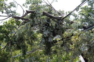
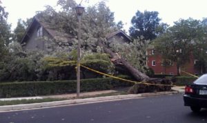
Already some power problems and falling trees and power lines have been reported. Dominion reported 423 customers without power in Arlington earlier this afternoon, but power has since been restored to most. Firefighters are currently on the scene of a large tree that fell on to a house on the 2900 block of N. Oxford Street, in the Bellevue Forest neighborhood. The house was unoccupied at the time and nobody was hurt.

In the following Arlington Alert, the county says they’re starting to receive reports of flooded roads. Long Bridge Drive has already been closed due to flooding.

Hurricane Sandy is about to get worse.

Think of the derecho storm with high winds in June that lasted 24 minutes. The winds we’re about to experience beginning this afternoon are like the derecho, but they will last for 24 hours.

To paraphrase: Instead of 24 minutes of dangerous winds, it will be 24 hours of dangerous conditions.

We need you to stay off the roads and indoors as travel will become extremely dangerous with winds and heavy rain beginning this afternoon.

Several inches of rain and potential flooding could start happening. We’re beginning to get reports of flooded roads.

Have your battery-powered radio available and make sure your phone is fully charged if you lose power. We will share any shelter openings and other updates via our information channels such as our Emergency Management Blog, County Web Page and Arlington Alert.

Separately, the county is advising residents to secure loose items outside, if that can be done safely, and to avoid driving into high standing water. “Please exercise extreme caution” in the storm, the county said.

As high winds approach, exercise extreme caution. For the safety of our employees, Arlington County will implement its high-wind policy. As the wind approaches sustained speeds of 30-40-45 miles-per-hour, we will pull crews off the roads and in to a safe place. This includes Parks staff, who will suspend responding to downed tree calls during these dangerous wind conditions. As winds approach very high, sustained speeds, police and fire personnel will respond only to life-threatening calls.

Please exercise extreme caution; emergency managers urge you to go a safe place and stay there. We also encourage you to remove/secure loose items from your yard, balcony, deck, etc., as these could become dangerous projectiles in high wind. Do this if you can do so safely.

Monday & Tuesday trash and recycling services are delayed until Wednesday. Bring your trash carts and recycling bins into your house/garage; do not leave them outside, as they could become airborne and dangerous.

Also, it’s a good idea to remove or secure loose items from your yard, balcony, deck, etc., as these could become dangerous projectiles in high wind. Do this if you can do so safely.

We are receiving reports of ponding on some roads. Standing water is deceptive; do not drive into standing water. Do not go out onto the roads if at all possible; we urge you to get to a safe place and stay there.

  • Do not drive into standing water. If floodwaters rise around your car, abandon the car and move to higher ground if you can do so safely. You and the vehicle can be quickly swept away.
  • Six inches of water will reach the bottom of most passenger cars, causing loss of control and possible stalling.
  • A foot of water will float many vehicles .
  • Two feet of rushing water can carry away most vehicles including SUVs and pick-ups.

Update at 12:20 p.m. — Schools will remain closed tomorrow. All Tuesday classes and activities at Arlington Public Schools have been canceled, according to a recorded message from the school system.

Arlington County is urging residents to stay put until the heavy rain and wind of Hurricane Sandy blows through the area over the next day or so.

“Arlington emergency managers urge everyone to stay where you are,” the county said in a media alert this morning. “High winds and the danger of falling trees will present an extremely unsafe environment. Get yourself to a safe place and stay there.”

With widespread damage to trees expected during the storm, the county is asking residents to call 703-228-6525 to report downed trees. Only in the event of a life-threatening emergency should residents call 9-1-1, the county said.

For non-emergency assistance, residents can call the non-emergency police and fire line at 703-558-2222. Requests for storm aid can be made by calling the Arlington Department of Human Services at 703-228-1300 or the regional aid hotline at 2-1-1.

Sandy is expected to drop up to 5-10 inches of rain on the D.C. area and pack damaging wind gusts of 70-80 miles per hour. From the National Weather Service:

AT 11 AM EDT… THE CENTER OF HURRICANE SANDY WAS LOCATED NEAR LATITUDE 37.5N… LONGITUDE 71.5W. THIS WAS ABOUT 315 MILES EAST OF WASHINGTON DC. SANDY WAS MOVING NORTHWEST AT 18 MPH… WITH MAXIMUM SUSTAINED WINDS OF 90 MPH. SANDY IS FORECAST TO MAKE LANDFALL ALONG THE SOUTHERN NEW JERSEY COAST EARLY TONIGHT… WITH A LITTLE STRENGTHENING POSSIBLE BEFORE LANDFALL. SANDY WILL SEVERELY IMPACT THE REGION WELL BEFORE IT COMES ASHORE.

SUMMARY OF THREATS —————— * THE MAIN IMMEDIATE THREATS FOR SANDY WILL BE STRONG WINDS RESULTING IN WIDESPREAD DOWNED TREES AND POWER/COMMUNICATIONS OUTAGES… AND HEAVY RAINS WHICH WILL RESULT IN EXTENSIVE FLOODING OF LOCAL STREAMS AND CREEKS. * BLIZZARD CONDITIONS ARE FORECAST IN THE POTOMAC HIGHLANDS AT ELEVATIONS ABOVE 2000 FEET WHERE 18 TO 24 INCHES ARE FORECAST. * MAJOR RIVER FLOODING IS LIKELY TO OCCUR… STARTING THIS AFTERNOON ON SMALLER WATERSHEDS WHICH WILL LEAD TO FLOODING ON THE MAIN-STEM RIVERS SUCH AS THE POTOMAC AND THE SHENANDOAH.

CHANGES SINCE LAST LOCAL STATEMENT ———————————- * THE TIMING OF THE PEAK WINDS FROM SANDY ARE NOW EXPECTED FROM LATE THIS AFTERNOON TO DAYBREAK ON WEDNESDAY. * RAINFALL AMOUNTS HAVE BEEN INCREASED. THE GREATER BALTIMORE METRO AREA IS NOW FORECAST TO RECEIVE 8 TO 12 INCHES OF RAIN… WITH LOCALLY HIGHER AMOUNTS. * THE POTOMAC RIVER IS LIKELY TO GO INTO FLOOD STAGE BEGINNING AROUND WEDNESDAY AND LASTING THROUGH FRIDAY.

HIGH WINDS ———- * WINDS WILL INCREASE STEADILY TODAY… WITH THE MAXIMUM WIND GUSTS OCCURRING LATE THIS AFTERNOON THROUGH TUESDAY MORNING. * GENERALLY… SUSTAINED WINDS OF 30 TO 50 MPH WITH GUSTS TO 60 MPH CAN BE EXPECTED ACROSS THE ENTIRE REGION. * HURRICANE FORCE WIND GUSTS OF 70 AND POSSIBLY 80 MPH ARE EXPECTED TO IMPACT A REGION LOCATED BETWEEN BEL AIR MD… POINT LOOKOUT MD… AND HAGERSTOWN MD BETWEEN 6 PM THIS EVENING TO 6 AM TUESDAY. THIS INCLUDES THE GREATER BALTIMORE AND WASHINGTON METROPOLITAN AREAS. * COUPLED WITH HEAVY RAINS FROM SANDY… THE HIGH WINDS WILL RESULT IN SIGNIFICANT TREE DAMAGE AND POWER LINE DAMAGE.

RAINFALL AND FLOODING ——————— * 8 TO 12 INCHES OF RAIN IN NORTHEAST AND NORTH CENTRAL MD INCLUDING THE BALTIMORE METRO AREA AND ALONG THE WEST SHORE OF THE BAY. * 5 TO 10 INCHES OF RAIN IS EXPECTED ACROSS THE FREDERICK… WASHINGTON AND FREDERICKSBURG METRO AREAS. * 3 TO 6 INCHES OF RAIN IS EXPECTED FOR EASTERN WEST VIRGINIA AND VIRGINIA… WITH THE EXCEPTION OF THE DC METRO COUNTIES… AS WELL AS WESTERN MARYLAND WEST OF HANCOCK MD. * THIS AMOUNT OF RAIN WILL LIKELY RESULT IN EXTENSIVE AND DANGEROUS FLOODING OF LOCAL STREAMS AND CREEKS STARTING THIS AFTERNOON AND LASTING INTO WEDNESDAY.

MAIN-STEM RIVER FLOODING ———————— * THE POTOMAC RIVER WILL LIKELY START FLOODING TUESDAY NIGHT AND CONTINUE THROUGH THE END OF THE WEEK. * THE MONOCACY RIVER IS FORECAST TO FLOOD LATER TODAY AND CONTINUE TO BE IN MAJOR FLOOD THROUGH EARLY THURSDAY. LEVELS FORECAST HAVE NOT BEEN SEEN SINCE AGNES IN 1972.


No Sandbag Distribution in Arlington — Contrary to some rumors, Arlington County is not distributing sandbags to residents concerned about flooding. “Arlington County, fortunately, does not have significant river front areas that are subject to flooding (e.g., Georgetown, Old Town),” Arlington County Director of Communications Diana Sun told ARLnow.com this morning.” She said that county staff is “focused on the highest priorities.”

Long Bridge Drive Flooded — Long Bridge Drive, near Crystal City, has flooded as a result of rain overnight and is being closed to traffic by police. The flood-prone road is the only street that leads to the parking lots for Long Bridge Park.

Pentagon City Mall ClosedUpdated at 10:45 a.m. — The Fashion Centre at Pentagon City will be closed today (Monday) due to Hurricane Sandy. Ballston Common Mall will be closing at 2:00 p.m. [Facebook]

Artisphere’s Per-Visitor Subsidy — Based on its new Fiscal Year 2012 year-end report, Artisphere required a taxpayer subsidy equivalent to $41.85 for each of the cultural center’s 55,607 visitors over the course of a year. [Sun Gazette]

Cuccinelli May Investigate Moran Video — The State Board of Elections has asked Virginia Attorney General Ken Cuccinelli to investigate a video of Rep. Jim Moran’s son discussing possible voter fraud. Patrick Murray, Moran’s Republican challenger, said “we need to know that [our electoral process] has not been corrupted.” He also called on U.S. Attorney General Eric Holder to investigate the video. The Arlington County Police Department is currently investigating the video, as well. [Washington Post, Murray for Congress]

High School Football Update — Yorktown High School remains undefeated (9-0) following this weekend’s high school football action. Wakefield High School remains winless (0-9). Washington-Lee chalked up a victory over the weekend and is now 5-4. [Sun Gazette]


(Updated at 8:45 p.m.) Winds are picking up and rain is starting to fall, and Arlington County is taking steps to brace for the impacts of Hurricane Sandy.

All classes and activities have been canceled Monday at Arlington Public Schools in advance of the storm, which is now expected to drop 5 to 10 inches of rain and pack wind gusts up to 70 miles per hour between tonight and Tuesday.

Metro has suspended all rail, bus and MetroAccess service starting Monday. Service will remain suspended “until further notice.” ART bus service has also been suspended Monday.

Many flights departing out of and arriving at Reagan National Airport on Monday have been canceled, according to the airport’s Twitter account, although the airport itself will remain open.

Federal government offices will be closed Monday, and non-emergency employees are being granted excused absences.

Arlington courts, libraries, community centers and government offices will be closed Monday. Trash and recycling collection in Arlington has been suspended on Monday and Tuesday. Arlington County Manager Barbara Donnellan, meanwhile, has declared a state of emergency.

From a county press release:

County Manager Barbara Donnellan today signed a Declaration of Local Emergency for Arlington County in response to Hurricane Sandy. The County is activating its Emergency Operations Center (EOC) to manage storm response. The hurricane is projected to impact the Arlington area with heavy rain and damaging winds from late Sunday night through Tuesday night.

This storm is expected to produce rainfall of between 5 and 10 inches in our area, which could cause localized flooding on area streets, low-lying areas, creeks and streams. The County expects significant tree damage, and residents, businesses and visitors should plan for widespread power outages as a result.

To stay informed, continue to monitor Arlington Alert , the County website (www.arlingtonva.us ), local news and weather stations, and all other news channels.

What Residents Can Do to Prepare

  • Have flashlights and extra batteries, a battery-powered and/or hand-crank radio in case power goes out. Ensure mobile phones are fully charged. (And consider plugging in your old-fashioned land-line phone.)
  • Have food that does not need refrigeration and one gallon of water per person per day. Other important items are a first aid kit, medication, and other supplies.
  • Don’t forget your pets and others who may need special assistance, including elderly neighbors.
  • With heavy winds expected, ensure outside items in yards and on decks and patios are secure.
  • Clean out gutters, storm drains, etc. (keeping drains clear of trash, leaves and branches) so rainwaters can easily flow, reducing possible flooding and ponding. Also rake leaves to cut down on flying debris and prevent clogged storm drains.
  • Have a communications plan. Make sure all family members understand who to call if you get separated.
  • If you live in an area prone to flooding, be prepared to relocate your family and vehicle before flood waters have an impact. If you are driving and see a street that is flooded, turn around.

More details on the County website  , including who to call after the storm, clean-up tips, handling home damage, and more. We will continue to update this page throughout the storm response; check back for updates or sign up for an RSS feed.

Emergency Winter Shelter Opening

The Emergency Winter Shelter  (EWS) at Courthouse will open today, Sunday, Oct. 28, at 3pm and will stay open as long as needed (it normally opens Nov. 1). A-SPAN is conducting outreach to let the homeless population know this resource is available.

Key Phone Numbers

Write these down or print them out so you have then handy in case you lose power.

  • Power Outages: Dominion Virginia Power, 1-866-DOM-HELP (1-866-366-4357)
  • Natural Gas Emergencies: Washington Gas 703-750-1400 or 800-752-7520. If you smell gas, leave and call 9-1-1. Washington Gas Safety Page 
  • Trees Down : 703-228-6525
  • Street Flooding, Water, Sewer and Storm-sewer: 703-228-6555 (emergency hotline)
    (Note: During high rains, call volume is often greater than normal. Operators will respond to your call as soon as they can.)
  • Traffic Signal Outages: 703-228-6511

Dominion Power Update

Dominion is currently expecting significant impact from the effects of Hurricane Sandy for much of their service territory. Their Northwest Regional Storm Center is regularly providing updates to government Emergency Operation Center (EOCs) in the region. Other news from Dominion:

  • Dominion will open its Northwest Regional Storm Center at 6AM Monday October 29.
  • 8,800 medical condition customers have been contacted via automated calling feature, in preparation of Hurricane Sandy, with the following message: This is an important message from Dominion. In advance of Hurricane Sandy, customers with medical needs should make preparations for extended outages. Participation in the medical needs program does not mean that you will be the first to have power restored. Please make an emergency plan for backup power or arrangements to relocate until power can be restored to your home. Thank you.
  • They are working to secure additional resources to complement line, patrol and support teams.
  • Additional tree crews are on hand to assist with restoration efforts.

Gov. Bob McDonnell declared a state of emergency in Virginia on Friday.

Utilities and transit agencies are also preparing for the storm. Dominion says its crews, and mutual aid crews called in from out of state, are standing by to restore power following the storm. The company is warning of the potential for “prolonged power outages,” however.
“When customers lose their electric service during a major storm, their primary question is when their electricity will be restored,” said Dominion rep Rodney Blevins. “They expect our bucket trucks and line crews to be in the field as soon as the storm ends, or sooner, but strong winds may make working conditions too risky to proceed while the storm lingers.”

Although service will be suspended after Sunday night, WMATA says it has been testing drainage pumping stations and has been placing sandbags at Metro entrances in preparation for heavy rains.

“Customers are strongly encouraged to check wmata.com before traveling and to sign up for MetroAlerts to receive service information via email or text message,” the agency said via its web site. “During severe weather, customers are advised to travel only if absolutely necessary.”

Arlington County has compiled a list of phone numbers and storm clean-up tips residents can use to check on power outages, to report downed trees and wires, and to deal with water damage. Those seeking critical assistance — like food, shelter or other aid — can also call 2-1-1, a central hotline for human service agencies in the D.C. area. Tips for keeping pets safe in a storm are available online from FEMA.

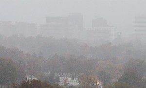
Photo (top) courtesy @JoePraino


Arlington County officials say they’re closely monitoring the path of Hurricane Sandy.

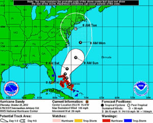
Sandy, which is currently churning in the Atlantic Ocean near the Bahamas, is expected to make its way north and threaten the D.C. area. Forecasters from the Capital Weather Gang say there’s a 75 percent chance of a direct or indirect hit from Sandy, which could bring 2 to 8 inches of rain and wind gusts from 50 to over 75 miles per hour.

In a phone interview, Arlington’s acting Deputy Director of Emergency Management, Bonnie Regan, said an email was sent Thursday to emergency support personnel in various county departments, asking them to check generators, fuel supplies, and weekend staff availability.

Regan said she was planning to participate in a conference call with forecasters, organized by the Metropolitan Washington Council of Governments, which was to take place at 3:30 Thursday afternoon. She said the county was waiting for a more definitive forecast of Sandy’s path before taking additional steps. The storm isn’t expected to hit until Sunday or Monday.

“We’re waiting for more information,” Regan said. “There are lots of different models out there right now. They’re not able to exactly tell us which way it’s going to come.”

Still, Regan said the county will act swiftly to staff its Emergency Operations Center for the storm if it becomes clear that D.C. is in Sandy’s likely path.

“Because there’s a weekend involved, I don’t want to scramble at the last minute to try to find people,” she said. “I always say, plan for the worst and hope for the best.”

Three Office of Emergency Management staffers are already scheduled to be on duty on Sunday, Regan said. They’ll be staffing the unified command center for the Marine Corps Marathon, which is scheduled to start in Arlington around 8:00 that morning.

VDOT says it is also closely monitoring Sandy while “making all appropriate preparations and taking all precautions.”


Historic ‘Arlington Oak’ Toppled — A historic tree in Arlington National Cemetery is now firewood thanks to Hurricane Irene. The cemetery revealed last night that the ‘Arlington Oak’ at the Kennedy gravesite had been knocked down by the storm’s high winds and steady rains. “That tree had a significant legacy here,” said a cemetery official. [CBS News]

Firefighters Collecting for MDA — Arlington’s firefighters are out “filling the boot” at busy intersections to collect money for the Muscular Dystrophy Association. A medic crew was out at the intersection of Glebe Road and Columbia Pike last night, and the crew from Engine 109 was spotted out in the Shirlington area, among others. [Shirlington Village Blog]

Are Arlington’s Green Grants Worth It? — Arlington received $3.2 million in federal green energy grants in 2009, according to an op-ed in the Wall Street Journal. But was it worth it? One of the grants — $300,000 — was spent to place solar panels on the roof of the Arlington Central Library, a move expected to save some $150,000 over 10-15 years. The Journal opines that it may not be the best investment to give “one of the five wealthiest counties in America free money.” [Wall Street Journal]

Flickr pool photo by BrianMKA


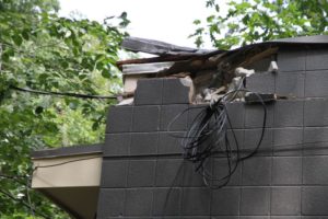
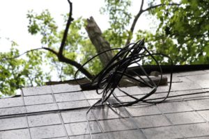
The newly-restored Lubber Run Amphitheater was damaged by a falling tree limb over the weekend.

The large, rotted tree limb, felled by the wind and rain of Hurricane Irene, hit the back of the amphitheater building and damaged the concrete brick parapet wall and capping. Some wiring also appeared to be damaged.

The damage is not enough to close the amphitheater for next weekend’s round of performances — the last of the summer — according to county spokeswoman Mary Curtius. She said that the power lines to the building are intact, but will be checked by an electrician. (Update at 2:05 p.m. — We’re now hearing that the power connection to the building may, in fact, have been damaged.)

The building will be repaired by a contractor, Curtius said. The county’s urban forester, meanwhile, will check the tree to make sure it doesn’t pose any additional danger.

Award-winning local rockers The Grandsons will perform at the amphitheater Friday night. On Saturday night the amphitheater will host a teen talent and movie night. Inception will be shown, rounding out the summer’s entertainment schedule.

Hat tip to twelvemilecircle.com


(Updated at 1:15 p.m.) As of 1:00 this afternoon, nearly 1,800 Dominion customers were still without power, according to a spokesperson.

At its peak, immediately after Hurricane Irene left the area yesterday morning, more than 14,000 Dominion customers were in the dark in Arlington.

“Arlington, Alexandria and Springfield experienced some significant damage,” said Dominion spokeswoman Le-Ha Anderson. “Due to that, we know that it will be Tuesday night before all of those customers are restored.”


It was one of the most hyped storms in recent memory.

Switch on the TV last week, and it sounded like a disaster movie in the making. As it approached, evacuations were ordered on the coast and local residents stocked up on supplies. Then, as Hurricane Irene finally made its way up the eastern seaboard, local TV stations and the cable news channels went with wall-to-wall coverage.

No doubt you’ve already seen the damage reports and the damage photos. In your mind, was the storm’s impact worse than or not as bad as expected?


Flickr pool photo courtesy @DrWeinz


Federal Government is Open — Federal government offices are open, 24 hours after the last remnants of Hurricane Irene left the area. Employees “have the option for unscheduled leave or unscheduled telework.” [OPM]

Video of Hurricane Damage — Arlington County created a video tour of some of the damage caused by Hurricane Irene. [YouTube]

Old Guard Soldiers Photograph Graves — Soldiers from the Army’s Old Guard — who perform ceremonial duties at Arlington National Cemetery — have been tasked with photographing hundreds of thousands of final resting places in an effort to account for every grave in the cemetery. They take the photos at night, after the day’s last funerals have been performed. [Associated Press]


View More Stories