Arlington County may be moving forward with plans to build the long-awaited boathouse in Rosslyn, but some are wondering why a site at Gravelly Point wasn’t chosen instead.

National Park Service spokesman Aaron LaRocca tells ARLnow that Rosslyn was chosen because “it best meets the purpose and need statement in the [environmental assessment] to enhance waterfront access and provide a boathouse facility along the Virginia shore of the Potomac for non-motorized, water based recreation” better than Gravelly Point.

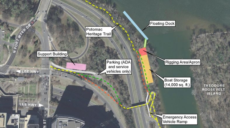
The County Board voted Tuesday to allow County Manager Mark Schwartz to sign a programmatic agreement that ends NPS’ environmental assessment of the decades-long project. This means NPS can now start start designing the boathouse in consultation with the county government and other local stakeholders, LaRocca said.

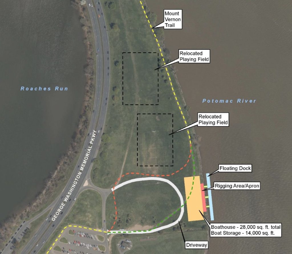
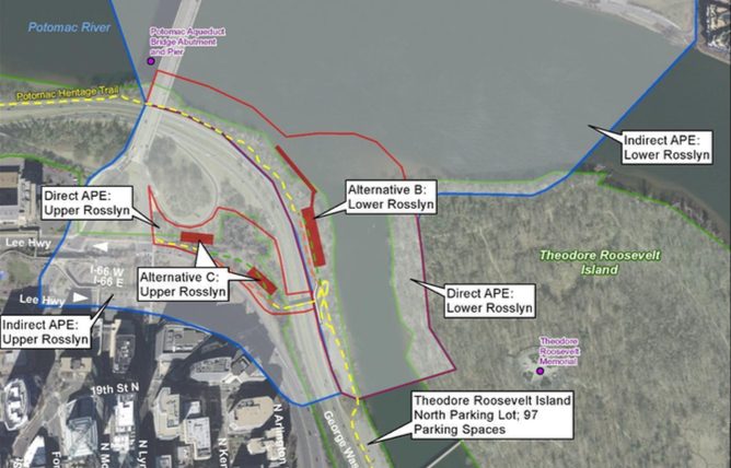
The environmental assessment examined several alternative sites for the boat house, including Gravelly Point, just north of Reagan National Airport.

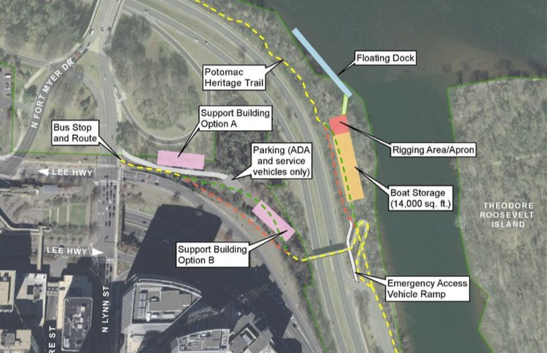
Local activist Suzanne Smith Sundburg argued Gravelly Point should have been chosen instead in a letter to the Board before the vote, citing the trees on the Rosslyn site at 2105 N. Lynn Street (formerly known as 1101 Lee Highway) that would need to be cut down. Sundburg also cited the “highly destructive dredging of 52,000 square feet of precious Potomac River wetlands” also needed.

LaRocca said that the Gravelly Point site was unsuitable from an environmental perspective because it lies within a floodplain, whereas the Rosslyn site does not.

In addition to better access to public transit, he added that the Rosslyn site is also “the preferred alternative” because the water is calmer, which would improve boater safety and allow for more days on the river as compared to the Gravelly Point location.

Independent County Board candidate Audrey Clement echoed Sundburg’s concerns Tuesday night, and added that the Rosslyn site would also require a parking lot and an access road to be built, whereas Gravelly Point already has parking and ready access to the GW Parkway.

“Gravelly Point was proposed to avoid potentially sensitive resources and reduce the amount of road infrastructure needed to access the site, compared to other locations along this part of the Potomac River,” says the NPS environmental assessment.

The 106-page study notes that Gravelly Point has turf grass, not trees, and existing parking facilities, but it also notes that wildlife like small rodents, fish, and birds were recorded in “statistically lower” amounts at the Rosslyn site than at Gravelly Point.

LaRocca said NPS recommended the Rosslyn site after weighing the environmental impact and service needs, along with other factors.

Board member Erik Gutshall said he expects improvements to the boathouse plan to be made in the next design phase, and that the current plan’s shortcomings were not a reason for the Board to reject “broad brush” of the project Tuesday night.

Image 1 via County Board, Image 2 via National Park Service


Metro Removes 3000-Series from Service — “Metro overnight temporarily removed all 3000-series cars from service after we received a report of a door malfunction for which we need to identify the cause. This voluntary safety action reduces the number of available rail cars by ~15%” [Twitter, Twitter]

Courthouse Hotel May Become Apartments — “The owner of an Arlington hotel is now hoping to flip the building into residential space instead. The Arlington Court Suites Hotel in Courthouse could soon become a 180-unit apartment building dubbed ‘Park Arlington at Courthouse,’ according to plans filed with the county this week.” [Washington Business Journal]

More HQ2 Jobs Listed — There are now 18 open HQ2 jobs listed on Amazon’s website, with roles ranging from HR to sales to software engineer. Some of the jobs were reportedly first listed as working out of Amazon’s existing Ballston office, the long-term prospects for which are now in question. [Amazon, Washington Business Journal]

NPS’ Massive GW Parkway Backlog — “ABC7 asked the National Park Service how big the [GW Parkway’s] maintenance problem is. The… Parkway has a maintenance backlog of $717-million, but that includes 25 sites, such as Arlington House and Great Falls Park. $649-million of that amount is for paved roads. 33 million vehicles drive on the GW Parkway every year.” [WJLA, Twitter]

Va. Reps Call for Telework Option During ‘Summer Shutdown’ — Rep. Don Beyer (D-Va.) and other Northern Virginia representatives have written a letter to the director of the Office of Personnel Management, calling for federal employees to be given expanded telework options during the May 25-Sept. 8 “Summer Shutdown” of Metro stations in Alexandria. [House of Representatives]

Yellow Line Extension Starting This Weekend — “Metro today announced it will begin running all Yellow Line trains to Greenbelt more than a month earlier than expected – starting Saturday, May 25 – when the Platform Improvement Project begins at six Yellow and Blue line stations south of Reagan National Airport.” [PoPville]

Photo courtesy Peter Golkin


Arlington County Board is scheduled to vote on the latest step in the decades-long plan to build a Rosslyn boathouse.

On Saturday, members are set to consider a “programmatic agreement” to build a boathouse at 1101 Lee Highway in Rosslyn, which would allow non-motorized boats like kayaks to launch into the Potomac from Arlington’s shore.

The county purchased land south of the Key Bridge in 2014 to help hasten the permitting process with the National Park Service, which is overseeing the project.

County spokeswoman Jennifer Smith said this agreement, if approved, would bring the country one paddle closer to a boathouse:

The Programmatic Agreement is a routine element of the environmental review process and reflects the intent of National Park Service and the various regional parties involved in development of the project to cooperate in implementing it. The Board vote is required to authorize the County Manager to sign the agreement. This administrative step, if approved by the Board and by other regional entities, would allow for the National Park Service’s Environmental Assessment to be completed. Completing the EA is an important next step in the project’s timeline. A public process for development of the boathouse would be established separately.

A copy of the design plans shared in a staff report to the Board call for:

  • a 14,000-square-foot boat storage house that’s designed to be flood-resistant
  • a 300-foot-long dock for non motorized boats (like kayaks)
  • a building for bathrooms, locker rooms, educational rooms, and offices
  • an ADA-compliant parking area
  • a 300-foot-long emergency vehicle access lane

“The Arlington County and Vicinity Boathouse project is included in the Adopted Fiscal Years (FY) 2019-2028 Capital Improvement Plan (CIP), which envisions $500,000 in FY 2022 for development of the management model and formulation of the long-term use arrangement and $2.245 million in FY 2026 for the final design of the Boathouse project,” the staff report says.

It’s been almost 25 years since the “boathouse task force” formed to propose the idea, but the project didn’t gain momentum until 2012 when the National Park Service began studying potential environmental impacts. The study was put on hold several times, before resuming in 2016.

At the time, the Park Service worried about how construction could affect flood plains along the river, as well as species that called the waterway home.

In this week’s staff report, a resolution says that the Park Service determined that the boathouse could “have a direct adverse effect on the George Washington Memorial Parkway Historic District and an indirect adverse effect on Theodore Roosevelt Island.” However, it approved going forward provided the following steps were taken to reduce impact:

  1. Restricting and minimizing ground and vegetation disturbance during construction, including limiting tree removal.
  2. Minimizing the size of construction equipment and using minimally invasive construction methods.
  3. Developing a “light on the land” facility with a minimal footprint and massing that is in scale with the surrounding landscape.
  4. Limiting the depth of excavation to avoid disturbing any unknown archeological resources below the depth of previous testing.
  5. Keeping a 50-100 foot area of protection around known archeological sites where heavy equipment is not allowed to help avoid compression/compaction.
  6. Applying avoidance and minimization strategies to staging and storage areas as well.

The project has many fans in the county’s rowing community, which recently banded together to reinforce their support for the water sport after APS threatened to cut the high school teams from the county’s budget.

The Arlington Boathouse Foundation writes on its website that although the county was among the first to introduce rowing teams to its high schools, teams for many years have had to launch crew boats out of D.C. “The George Washington Memorial Parkway severed Arlington’s access to its own shoreline,” the foundation notes.

Since the D.C. boathouse serves multiple jurisdictions, accessing those facilities can be tricky.

“Some area boathouses have a two- to three-year waiting list for membership and an additional waiting list for storage space for a single scull,” the National Park Service wrote on its website about the Rosslyn plan.


Update at 11:50 a.m. on 5/13/19 — Per the National Park Service: “Due to continued rain, the National Park Service now hopes to reopen one lane in time for the evening rush hour on Tuesday, May 14. If this schedule changes, we will share an update.”

Earlier: The northbound lanes of the GW Parkway are closed just north of Arlington due to a large sinkhole.

Sinkholes have been a recurring problem on the Parkway, with the most recent sinkhole-related closure happening in March.

The Parkway’s northbound lanes are currently closed from Route 123 in McLean to the Beltway, with traffic backing up prior to the detour onto 123. The National Park Service issued the following press release about the closure Friday night.

The U.S. Park Police and National Park Service have closed the northbound lanes of the George Washington Memorial Parkway from Virginia Route 123, Chain Bridge Road to I-495 the Capital Beltway. The closure began around 6:45 p.m. when a U.S. Park Police officer observed a sinkhole. The northbound George Washington Memorial Parkway will remain closed in that area as engineers and work crews fully assess and repair the road.  Southbound travel lanes remain open.

The National Park Service took this action to ensure public safety, and no accidents have been reported.  Staff have continued to monitor the parkway since March when a sinkhole developed in the same area next to Dead Run.

The George Washington Memorial Parkway is a critical link in the national capital region’s transportation network, and closing it is never a decision that is made lightly. Drivers should follow local news or visit www.nps.gov/GWMP for the latest information.

Map via Google Maps


Federal officials think they have a good shot at winning $126 million in grant funds to make a series of badly needed repairs on a long section of the GW Parkway, and Northern Virginia’s congressional delegation is throwing its weight behind the effort.

The National Park Service, which maintains the road, is currently applying for a hefty U.S. Department of Transportation grant to fund rehabilitation work on a roughly eight-mile-long stretch of the parkway, as it runs between the Spout Run Parkway in Rosslyn and I-495. Now, both of Virginia’s senators and three local members of Congress are lending their support to the funding push, in a bid to finally afford some changes on the aging roadway.

“The proposed project will address serious deterioration of the GWMP and implement significant safety improvements,” the lawmakers wrote in a Jan. 8 letter to Transportation Secretary Elaine Chao. “This project will improve a critical link in the National Capital Region’s transportation network while preserving the historical and cultural characteristics that make the parkway one of the most scenic roadways in the country. These proposed improvements will increase the safety of visitors while significantly extending the life of the parkway.”

Sens. Tim Kaine and Mark Warner (both D-Va.) both signed the letter, as did Virginia Reps. Don Beyer (D-8th District) and Jennifer Wexton (D-10th District). Rep. Eleanor Holmes Norton, D.C.’s lone, non-voting representative in Congress also added her support.

The NPS says the construction work, set to cost about $150 million in all, will start at the parkway’s Spout Run Parkway exit and include:

  • Making drives smoother by replacing the asphalt pavement
  • Replacing guardrails and repairing walls
  • Repairing stormwater management systems to keep excess water from damaging the road
  • Constructing new concrete curbs
  • Rehabilitating parts of two historic, scenic overlooks
  • Lengthening entrance and exit lanes at some interchanges

Officials also hope to use the cash to replace the stormwater drainage grates that line the parkway, which have long made for a bumpy ride for drivers. They’re also envisioning adding four “emergency turnarounds,” in order to allow police to more easily redirect drivers who stop on the road due to a crash or inclement weather.

The construction would also include improvements at the parkway’s interchange with Chain Bridge Road in McLean, like adding a new traffic signal to the area.

The lawmakers note in the letter that this northern stretch of the parkway was first built in 1962, and with more than 33 million vehicles using the road each year, it’s badly deteriorated in the decades since.

The NPS is hoping to win the funding through the Department of Transportation’s “Nationally Significant Federal Land and Tribal Projects” program. In a release, park service officials said they believe the project “will compete well” for cash through that program, given the parkway’s “significance” and the fact that the NPS has already wrapped up schematic design work for the construction.

If all goes well, officials hope to kick off construction sometime next year.


Transportation officials are proposing a host of safety improvements for Memorial Circle, a confusing confluence of roads connecting Arlington National Cemetery to the Arlington Memorial Bridge.

The circle has long been the site of all manner of dangerous crashes, particularly those involving cyclists and pedestrians looking to access the nearby Mt. Vernon Trail or cross into D.C. But the National Park Service has drawn up a series of changes for the roads in the area designed to address the issue, including traffic pattern changes to transform the circle into something more like a traditional roundabout.

“The project area is at a major convergence of regional roadways and modes that interact through a complex series of roadway merges (on-ramps), weaves, diverges (off-ramps), and intersections, resulting in traffic congestion and crashes,” NPS planners wrote in a November environmental assessment. “The proposed action would change the way area users access and circulate through the area by car, bicycle, or foot.”

Officials estimate that the area saw approximately 600 crashes between 2006 and 2012. Lawmakers previously secured some safety improvements for the G.W. Parkway and the circle to try to address the issue. The new NPS proposal would address not only the circle itself, but also the roads approaching the area from both the north and south: S. Arlington Blvd and Washington Blvd.

Perhaps the most substantial change park officials are proposing would be cutting back on one lane of traffic in the circle, in order to “allow the circle to function more like a modern roundabout,” the NPS wrote. That means that drivers in the circle would have the right of way, and anyone entering the circle would need to yield to them.

The NPS also plans to split up an island on the east side of the circle, near where it meets the Memorial Bridge, allowing two westbound lanes coming from the bridge to “bypass the circle and head north onto S. Arlington Boulevard” and one lane of traffic to proceed and enter the circle.

For roads north of the circle, officials are proposing some improved signage at the various intersections, including “fluorescent yellow advance pedestrian crossing warning signs” at some and “rapid flashing beacon” signs at others.

But they’re also envisioning more dramatic improvements, like reducing Washington Blvd down to one lane, and removing both the “existing southern exit ramp connecting S. Arlington Blvd and S. Washington Blvd” and “the existing far left exit lane of S. Arlington Blvd.”

As S. Arlington Blvd exits the circle, the NPS also envisions reducing the road from three lanes down to two leading up to the crosswalk. The existing far left lane leading onto a ramp to S. Washington Blvd is slated to be removed, as is the exit ramp itself.

The NPS is planning similar pedestrian sign improvements for intersections south of the circle, as well as other lane reductions.

One major change would be the construction of a new concrete island where Washington Blvd enters the circle to its south, allowing two lanes of the road to bypass the circle and reach the Memorial Bridge, and one lane to enter the circle. That would require a slightly widening of the road in the area, the NPS wrote.

The plans also call for Washington Blvd to be reduced from four lanes to three south of the circle “in order to simplify merging patterns,” while the G.W. Parkway would be widened “to add an acceleration lane allowing traffic from Arlington Blvd to enter the parkway in its own dedicated lane before merging onto the two-lane parkway.”

Additionally, the NPS envisions relocating two bike and pedestrians crossings south of the circle. One, located as a trail crossing Washington Blvd, “would be relocated closer to the Circle, to allow pedestrians and bicyclists to cross where vehicle speeds are slower and where drivers are anticipating conflicts.” The other, designed to help people cross the parkway to the southeast of the circle, would be moved slightly further north of the parkway.

The NPS traffic analysis of these proposed changes suggest they’d generate “an overall improvement” in congestion on the roads, in addition to substantial safety upgrades.

People in the bicycling community are pretty skeptical of the latter assertion, however.

The NPS is accepting comments on the plans through Dec. 29.


Major construction work on the Arlington Memorial Bridge kicked off late last night (Sunday), snarling traffic for thousands of commuters headed into D.C. this morning.

Traffic cameras and maps showed heavy backups along both I-395 and Washington Blvd approaching the bridge for the morning rush hour. Other nearby roads, like the G.W. Parkway and Arlington Blvd, also saw heavy delays, no doubt worsened by the morning’s dreary conditions.

The National Park Service has closed three of the bridge’s six lanes to allow for the $227 million rehab project, which planners say is needed to avoid a full shutdown of the bridge in the coming years.

The NPS plans to keep one eastbound lane and one westbound lane open at all times, then reverse one lane to match the direction of traffic in the morning and afternoon rush hours. One of the bridge’s sidewalks will also be closed at all times as the work continues.

AAA is warning commuters to avoid the bridge if at all possible between now and the expected end of construction in 2021, reasoning that the delays for the 24.8 million vehicles to cross the bridge each year are too substantial to be ignored.

“If possible, avoid the Arlington Memorial Bridge altogether. Seek alternate routes and try other modes of transportation, if you can, while construction is underway,” John Townsend, a spokesman for AAA Mid-Atlantic, wrote in a statement. “Plan your trips across and around the Memorial Bridge. If you must use the bridge, do the right thing, drive carefully and slowly through the construction site, watch for construction workers, expect changing travel patterns and possible delays, exercise extreme caution, and minimize distractions.”

The NPS has details about the bridge’s new traffic pattern, and suggestions for commuters looking to avoid the bridge, available on its website.


The Mt. Vernon Trail is currently blocked near Roosevelt Island after someone tried to drive a piece of large construction equipment over a rickety wooden bridge.

The wooden plank bridge carries trail traffic in the area of Roosevelt Island and the Roosevelt Bridge, near Rosslyn. It is noted for being slippery when wet and generally uneven at all times, causing bikes to shake as cyclists ride over it.

Earlier today, a large piece of construction equipment was driven over the bridge and, predictably, broke a number of boards before getting stuck. The National Park Service is currently working to assess and repair the structure so that the trail can be reopened.

“NPS and Federal Highway Administration engineers are assessing the bridge,” said NPS spokesman Jonathan Shafer. “We hope to reopen the bridge and this section of the Mt. Vernon Trail soon, but we don’t have a time set yet.”

Via Twitter, an NPS spokeswoman said they were “hoping to reopen by evening commute but not sure yet,” adding that cyclists can detour past the closure by crossing bridges into D.C. and back.

Shafer says the circumstances around how the equipment was driven onto the boardwalk are being investigated. He said the equipment does not belong to the park service.

“It was not NPS equipment,” he said. “U.S. Park Police are investigating this.”

Update at 5 p.m. — The trail has reopened, according to NPS.

Photos (1 & 4) via NPS/Twitter (2 & 3) via BikeArlington Forum


There may be yet more rain in the forecast, fresh on the heels of last month’s persistent storms, but don’t expect to see the sort of flooding that trapped dozens of people in their cars on the GW Parkway two weeks back.

That’s the word from National Park Service officials, who believe the waves of water covering the parkway back on July 17 were more a fluke than anything else.

The flooding, which impacted a stretch of the road as it winds past Reagan National Airport, was severe enough to strand about 25 cars on the parkway until firefighters could get them to safety. But the NPS doesn’t see much it can do to prevent that sort of flooding from happening again, simply because parkway officials believe it was largely a result of the extraordinarily rapid rate of rainfall.

Jonathan Shafer, a NPS spokesman, noted that meteorologists recorded more than 2.6 inches of rain per hour falling at the airport that day.

“Maintenance staff from [the parkway] think the drainage system there was overwhelmed by the large amount of runoff,” Shafer told ARLnow via email.

Shafer added that parkway “[does not] believe this area has flooded due to rain in recent memory,” though water main breaks have occasionally caused some problems north of the airport.

Warren Stewart, a 22-year resident of Northern Virginia, agrees that he’s never seen the parkway look as it did two weeks ago. He was driving toward D.C. to pick his son up from school on July 17 when he saw what looked like “a creek coming down the road.”

“From my truck back, it was not flooded and the cars in front of me were,” Stewart said. “They were bailing water out of their cars with buckets… Water rose up as high as their tail lights, for some of them.”

The parkway hasn’t experienced anything like the mid-July flooding since then, even as rain has continued to pound the region. That’s why Shafer thinks the best solution to avoiding any similar scary situations on the parkway is for drivers to “exercise caution” getting on the road when storms pick up.

“Conditions can change fast, and it’s hard to predict when and how the weather might affect them,” he wrote.

Shafer says the park service is hard at work studying drainage and stormwater management improvements on other sections of the parkway, though construction is likely years away.

Photo via @ArlingtonVaFD


A decades-long effort to build a boathouse along the banks of the Potomac River is lurching forward once more.

Officials with the National Park Service have wrapped up an environmental analysis of the project and settled on a preferred alternative near Rosslyn for its construction, in the latest bit of forward momentum for an initiative that has long bedeviled county leaders.

Local high schoolers have been particularly keen on seeing a new boathouse come to the fruition, as the closest access points for rowing teams have long been in Georgetown or Alexandria, but the project’s complexity has repeatedly stalled it.

NPS took control of Arlington’s portion of the Potomac shoreline after the construction of the GW Parkway, and the federal agency has spent years working off-and-on with the county to find a way to give local rowers easier access to the river. Arlington officials helped jump-start the process in 2014 by buying a parcel of land along Lee Highway just south of the Key Bridge, giving the NPS some added flexibility as it evaluated several options where the boathouse could be built.

Now, the agency is recommending a design that would involve building a 300-foot-long floating dock and 14,000 square feet of boat storage along the Potomac’s shoreline near Rosslyn, just across from Theodore Roosevelt Island. The plan also calls for building a support facility on the county-owned Lee Highway site with office space, locker rooms and handicapped parking.

NPS also evaluated plans to build the boathouse on the same site near the island without the support building, as well as an option that would involve building the boathouse on Gravelly Point near Reagan National Airport instead.

Yet the agency settled on its preferred alternative because the additional space off Lee Highway “allows for development of a smaller boat storage structure while providing additional support facilities outside the floodplain, off NPS property, and close to transit,” officials wrote in the environmental analysis.

They also noted that the Potomac is a bit calmer near the Rosslyn location, earning it higher marks than Gravelly Point. The close proximity of the Rosslyn Metro station and several local bus stops, in addition to the Custis bike trail, also won the option some praise.

While the agency found that any construction would have some limited impacts on the area’s wetlands and soil, it broadly didn’t foresee many stumbling blocks for the project to move forward. Nevertheless, any construction will require both federal and state permits to advance, and the county will need to work with federal officials to find funding for the effort.

In the meantime, however, NPS is accepting comments on the environmental analysis through July 30 on its website. The agency also plans to hold a July 12 open house at Washington-Lee High School on the project, starting at 6 p.m.

Hat tip to Chris Slatt


Arlington may get two new Capital Bikeshare stations, at Roosevelt Island and Gravelly Point.

The County Board is set to approve a “memorandum of understanding” with the National Park Service, which has to approve the bikeshare stations since they would be located on NPS land.

The approval would further the goal of an expansion of the bikeshare network along the Mt. Vernon Trail.

Responsibility for the installation and maintenance of the bikeshare facilities on NPS land would fall on the county, according to the memorandum. It also restricts any advertisements on the stations, and sets requirements for site preservation and, should the stations be removed in the future, restoration.

The office of the County Manager has recommended that the memorandum be approved at Saturday’s County Board meeting (April 21).

Currently there are about 440 stations and 3,700 Capital Bikeshare bikes in the region. As of 2017, 85 Bikeshare stations were in Arlington.


View More Stories