A coalition of businesses, neighborhood groups and transportation advocates are urging planners to include a bike and pedestrian trail along the long-planned replacement for the Long Bridge, a key railroad connection from Virginia into D.C.

A total of 15 organizations from Arlington, the District and the rest of the metropolitan Washington region penned a new letter last Thursday (Nov. 1) to both local and federal transportation officials working on the project, calling the inclusion of a trail alongside the bridge part of “a once in a generation opportunity to transform our regional transportation network.”

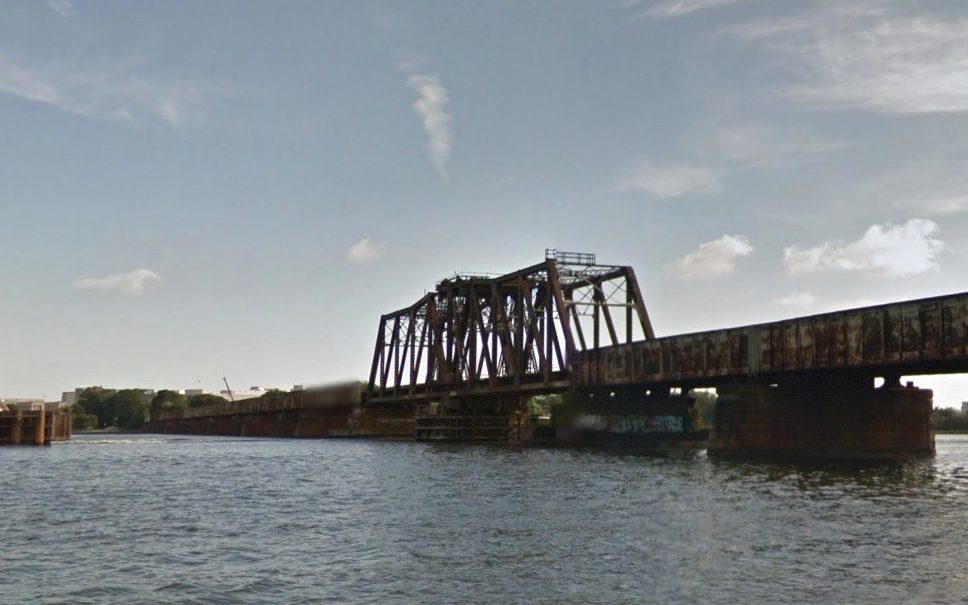
Planners are still sorting out exactly what the new bridge might look like. The original structure, which runs from near the Pentagon in Arlington to Southwest D.C., was built back in 1904, and officials from around the region have viewed replacing it as a necessary step for improving freight and passenger rail service between D.C. and Northern Virginia.

However, the prospect of including a trail alongside the new Long Bridge was not formally included in the various assessments of potential designs of the project. Accordingly, the group penning the letter sought to emphasize the benefits such a trail could have for the region’s commuters, and its economy.

The organizations — which include the Crystal City Civic Association, Friends of Long Bridge Park, the Washington Area Bicyclist Association, and Greater Greater Washington — stressed that any new trail crossing the Potomac River would provide “crucial links to several important regional trails.” The current crossing along the 14th Street Bridge does not offer a connection to the regional trail network on the D.C. side. of the bridge, and the friends group supporting the Mt. Vernon Trail co-signed the letter.

The groups also stressed that such a trail would spur economic development “by linking two key activity nodes in Southwest D.C. and Crystal City.” That goes doubly so if officials also follow the groups’ recommendation that the trail “connect to the esplanade in Long Bridge Park” and “extend as far towards L’Enfant Plaza as physically possible” on the D.C. side.

Perhaps most importantly, the letter urges that the trail “be funded and constructed concurrently with the rail component of the Long Bridge project,” and that it “should be incorporated into the design of the broader project in a way that optimizes the achievability of the project with regard to cost and complexity.”

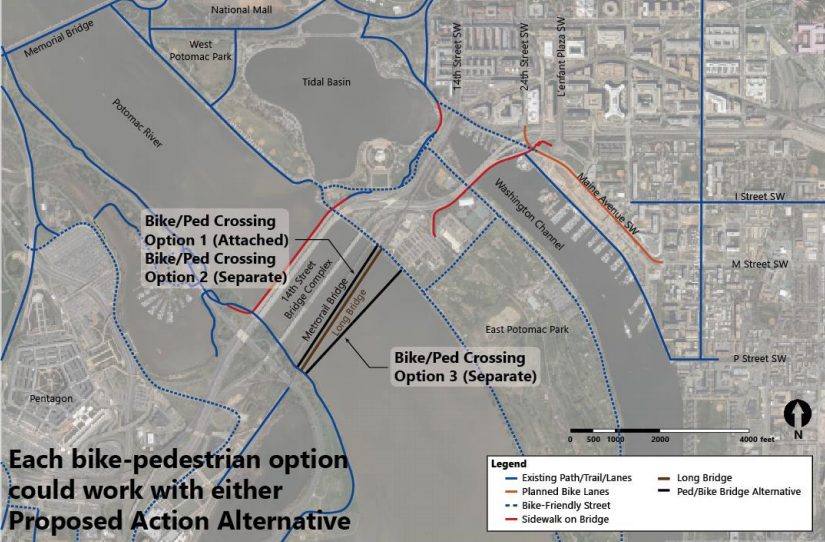
In a draft of an environmental impact statement prepared in late June, federal and local planners stress that any trail is “not part of the purpose and need” of the project. Even still, they agreed to include the study of four potential trail crossings in more detailed studies of the project to be completed over the coming months.

Planners have so far narrowed potential designs of the bridge replacement down to two options; both involve building a new, two-track bridge alongside the existing structure, but one alternative calls for the current bridge to stay in place and the other would involve fully replacing it.

Two of the trail designs call for building the crossing alongside the new bridge. Two others call for building the trail along its own, independent bridge: one proposal envisions it being upstream of the new two-track bridge, another would be downstream.

The transit advocates at Greater Greater Washington have expressed doubts about these proposals in the past, arguing that the designs “do the bare minimum” and represent a missed opportunity for planners. However, officials did agree to examine trail crossings over the Long Bridge Park side of the G.W. Parkway, “with an evaluation of connections to the Mount Vernon Trail and Ohio Drive S.W.,” two features that were previously championed by Greater Greater Washington.

Even still, there remains no guarantee that the trail will indeed be included in the project — the June report notes that Virginia rail officials noted “noted that the primary focus of the project is increasing rail capacity, and expressed significant concerns regarding safety and constructability of any combined-mode structure.”

Planners are still a long ways off from finalizing designs, however. The first step is settling on a single “preferred alternative” to examine in more detail, which planners hope to do within the next two months.

Officials then hope to have engineering and environmental analyses drawn up by summer 2019, and the project still needs additional funding. Virginia officials and the rail company CSX, which owns the bridge, have committed to chip in a total of $30 million for the effort, though there’s no telling just how much the bridge replacement might ultimately cost.


Though the biggest changes to the Four Mile Run Valley and its parks are still a few years out, Arlington officials are gearing up to make a few road changes in the area before major construction starts.

The county is planning some interim parking tweaks to free up space primarily along S. Four Mile Run Drive as it approaches Jennie Dean Park, in a bid to prepare for more substantial pedestrian and parking changes as the area evolves in the future. Officials are convening a community meeting to discuss the temporary changes tonight (Monday) at the Charles Drew Community Center (3500 23rd Street S.), starting at 7:30 p.m.

The affected roads up for discussion include:

  • S. Four Mile Run Drive major between Walter Reed Drive and Shirlington Road
  • S. Four Mile Run Drive minor west of Shirlington Road
  • S. Oxford Street south of S. Four Mile Run Drive
  • S. Oakland Street south of S. Four Mile Run Drive
  • S. Nelson Street south of S. Four Mile Run Drive
  • 27th Street S. between Shirlington Road to S. Nelson Street

According to the county’s website, “the changes are designed to provide better access for residents, park users and businesses in the area,” and are included as part of the long-range planning documents the County Board is currently finalizing for the Four Mile Run Valley.

The 4MRV Area Plan, set to be considered by the Planning Commission on Wednesday (Nov. 7), calls for a full “reconfiguration” of S. Four Mile Run Drive, in order for the county to test out some changes to make the area a bit more pedestrian-friendly and free up parking around Jennie Dean Park. Additions will primarily include “paint, bollards and landscaped planters,” according to the draft document.

“This would create a temporary 10-foot sidewalk on the south side of the street, a pedestrian crossing island at the intersections of Nelson and Oxford streets, and curb extensions (with planters) along the corridor,” the plan says. “Parking lanes would still be provided on both sides of the street. This interim solution would allow the county to pilot the new street design and collect input/data on vehicle speeds and delay, pedestrian comfort, safety and access to businesses.”

As an example, the planning document points to the intersection of S. Arlington Mill Drive and S. Walter Reed Drive, where the county is currently working on curb extensions and crosswalks to make the area more hospitable to cyclists and walkers alike.

The county anticipates that the interim changes will get set up this winter. County planner Richard Tucker even told the Transportation Commission last Thursday (Nov. 1) that some could be in place, “in the next several weeks,” so long as Monday’s meeting goes smoothly.

In the longer term, the area plan calls for “a parallel/angled parking strategy for Four Mile Run Drive with a concept for parallel parking on Arlington Mill Drive,” freeing up a bit more parking in an area that’s frequently in high demand.

“This concept creates more than 30 angled parking spaced immediately adjoining Jennie Dean Park,” the plan says. “Through regulatory and design changes, more than 250 additional spaces would be available during the daytime and evening. The cost of repainting streets in this configuration is far less than constructing new parking structures, and there may be opportunities for the county to explore shared parking agreements in existing nearby private parking garages.”


Street Smart Campaign to Start Up Next Week — “As part of the Arlington County Police Department’s overall traffic safety program, the Special Operations Section is again participating in the Metropolitan Washington Council of Governments’ Fall Street Smart campaign. This region-wide public safety campaign, which runs from November 5 – December 2, 2018, aims to educate drivers, pedestrians, bicyclists, and scooter operators about existing traffic laws and how to safely share our roadways.” [Arlington County]

County Board Lauds County Staff — In a video posted on YouTube, County Board Chair Katie Cristol and Vice Chair Christian Dorsey said “thank you” to Arlington County staff for the hard work that helped propel the county to high resident satisfaction ratings. “We are really proud of you… of your commitment to excellence and the role you play in making Arlington a terrific community.” [YouTube]

Bicycling Meetups This Fall — “Fall has arrived in Arlington, leaves have started to change colors, and temperatures are dipping overnight… If you’re looking for a good excuse to ride bikes and drink coffee this fall, like I do, there are plenty of local opportunities to make that happen.” [BikeArlington]

Photo courtesy Dennis Dimick


State transportation officials have firmed up their plans for a new bike and pedestrian bridge over Lee Highway in East Falls Church, putting the project on track for construction to kick off next spring.

VDOT unveiled final designs for the planned Washington & Old Dominion Trail bridge at a community meeting last Thursday (Oct. 11), sketching out more details on the bridge that is designed to offer a safer alternative to the trail’s current crossing at the highway’s intersection with Fairfax Drive.

The bridge’s design is largely unchanged from plans that VDOT showed off last summer. Some of the biggest changes include the removal of a barrier with streetlights running down the middle of the bridge and a change to the “piers” holding up the bridge — they now include open space in the middle of their “v” shape.

Officials initially proposed a design for the bridge that featured a trussed roof and red paint, yet some neighbors objected to those features, as well as the bridge’s potential to disrupt long-range plans for the area’s transportation networks.

Planners ultimately changed the bridge’s color and removed the roof, and even agreed to tweak the lighting features on the bridge too. Instead of a barrier lined by street lights, the bridge will now include lighting underneath the v-shaped posts running along its sides.

VDOT also detailed potential traffic disruptions prompted by the bridge’s construction at the meeting. Officials expect that there will be temporary closures on Lee Highway as the bridge’s beams and girders are put in place, and they expect that the fire lane on Fairfax Drive will be closed as construction continues. The W&OD Trail will also be realigned temporarily to allow for the construction, and could also see some temporary closures.

Planners are tentatively hoping to begin work on the bridge early next year, then wrap it up by the fall of 2020. The work will also move in tandem with the I-66 eastbound widening project, which VDOT also hopes to complete in late 2020.


Plans to make Rosslyn a bit easier to navigate for pedestrians and bicyclists are coming together, though county officials are concerned that some of the proposed changes might further snarl traffic in the area.

The county unveiled its latest designs for future of the “Core of Rosslyn” at a public meeting last Tuesday (Oct. 2), which includes plans to convert several streets around the Rosslyn Metro station into two-way roads, remove the Fort Myer Drive tunnel under Wilson Blvd and add a host of new connections for cyclists and walkers.

However, transportation planners worry that these alterations will produce “significant increases in gridlock” over the next decade or so, according to meeting documents.

In all, they’re projecting that the proposals will increase wait times at intersections in the neighborhood by a total of 19 minutes during the morning rush hour (with especially acute problems at the already jammed intersection of the Key Bridge, G.W. Parkway and Lee Highway) and a total of six minutes during the evening rush. They’re hoping to refine these designs in the coming months to address those issues, while maintaining the positive parts of the plan.

Certainly, planners expect the changes will result in substantial improvements in Rosslyn’s offerings for people who aren’t relying on cars to get around. The designs included 14 new or improved crosswalks for pedestrians, and more than 1.3 miles of new protected bike lanes included in the design. The lanes, largely set to run along Fort Myer Drive, N. Moore Street and N. Nash Street, are designed to ease bike connections to the Key Bridge and Mt. Vernon and Custis Trails.

The plans also keep alive the county’s long-considered possibility of building a car-free, “pedestrian corridor” running from 18th Street N.’s intersection with N. Oak Street to N. Kent Street, a change that would replace the Rosslyn skywalk system to make the Metro station more accessible.

Yet the county expects that this design would create some new challenges for walkers and cyclists as well. In particular, allowing two-way access on roads like N. Fort Myer Drive, N. Lynn Street and N. Kent Street will create a host of new “conflict points,” where cars are turning across crosswalks, prompting further delays for all involved.

That’s why Arlington officials are still accepting feedback on tweaks to the design.

Among the questions they want answered is whether people actually want to see the Fort Myer Drive tunnel filled in and transformed into a regular, signalized intersection with Wilson Blvd. The change would prompt additional delays at the intersections, and would involve “extensive construction costs and [a] long timeframe,” but could make it substantially easier for people to access the Rosslyn Metro station.

Similarly, planners want to know if making N. Lynn Street a two-way road is worth the extra traffic headaches it might entail. The county projects that the change “reduces confusion and allows for more direct routing” if it’s put in place, but it would also force officials to find new access points to the G.W. Parkway, I-66 and the Key Bridge.

The county plans to finish collecting feedback by Friday (Oct. 12), then unveil revised designs in the coming months. Officials hope to have final study recommendations for the area ready by sometime this winter.


Transportation planners will soon unveil the final design of a new bike and pedestrian bridge stretching over Lee Highway in East Falls Church.

VDOT plans to show off the finalized schematics for the Washington & Old Dominion Trail bridge at a community meeting next month, capping off a design process that drew plenty of flak from neighbors last year. The new bridge, which is being built as part of widening work on I-66 eastbound in the area, is designed to replace the trail’s current crossing at the highway’s intersection with Fairfax Drive and offer a safer environment for walkers and cyclists.

Officials had initially proposed a design for the bridge that featured a trussed roof and red paint, yet neighbors objected to those features, as well as the bridge’s potential to disrupt long-range plans for the area’s transportation networks.

But VDOT has since tweaked its design to address the most controversial features, proposing a bridge that’s gray in color without a trussed roof, in a bid to address some of those concerns. Even still, some questions about noise walls and public art lingered during a meeting on the project last year.

Planners will look to address those worries and more at an Oct. 11 meeting at Yorktown High School (5200 Yorktown Blvd) from 6:30-8:30 p.m., where they’ll deliver a presentation on “final design plans and aesthetic details.”

If all goes as planned, construction is set to start on the bridge by spring 2019 and run through fall 2020.


(Updated at 10 a.m.) Arlington Public Schools is indefinitely suspending its incentive program to push employees out of their cars, after the effort proved to be a bit too successful — and expensive.

The school system’s Transportation Demand Management (TDM) Commuter Program provides stipends to employees for turning to public transit, walking, bicycling, carpooling and other options to limit the number of cars going to and from schools.

It was budgeted for $222,600 last year, but School Board spokeswoman Linda Erdos said actual expenses were over $389,000. While the difference was covered in last year’s budget, Erdos said the budget for the program remained the same for FY 2019 without the same flexibility.

“No one wanted to make any changes, but we also had to find a way to reduce the growing deficit,” said Erdos in an email. “Carpoolers and transit users also receive stipends, and staff believed that maintaining those programs was important because it immediately reduces an employee’s direct costs for commuting (fares, toll fees and fuel) and keeps the number of cars in school parking lots lower.”

Erdos said the school system looked at reducing the stipend for walkers and bicyclists, but were still left with a $50,000 deficit.

At last Thursday’s School Board meeting (Aug. 30), Assistant Superintendent of Facilities and Operations John Chadwick stated that part of the reason the bicyclists’ and pedestrians’ incentives were targeted was because the data showed they’d be more likely to continue using those methods to get to school.

“Looking at numbers and usage, those members of staff who used to bike and walk would be most likely to continue using walking and biking to school,” said Chadwick. “If we applied the benefit to users of the carpool, we would likely get more people returning to single use cars and have more cars around our schools, more congestion, which causes safety concerns and issues of air quality. Faced with a difficult decision, we determined it would be most useful to suspend bike [and] walk benefits.”

Teachers at the Aug. 30 meeting said they dismayed by the decision.

“Two years ago, the incentive program helped me change my habits,” said Aaron Schuetz, a physics teacher at Yorktown High School. “Now, biking to work is my primary mode of transportation… [it was] disappointing to get email that it was cancelled.”

The suspension of the motor-free benefits was effective Sept. 1, which some teachers noted was an abrupt change.

“I was surprised to see benefits eliminated with three days notice,” said Jeffrey Bunting, an english teacher at Yorktown High School. “I found the process maybe a little cynical how it was eliminated… I fully agree there are probably improvements that can be done, but I encourage the Board and Mr. Chadwick not to throw the baby out with the bathwater.”

Erdos said the Office of Multimodal Transportation Planning in the Department of Facilities & Operations will continue to work on reorganizing the program and will release more information later this year about the changes.

Photo via Arlington Public Schools


(Updated at 4:05 p.m.) A pedestrian was struck by a taxi cab in a crosswalk along a busy section of Columbia Pike, per scanner traffic.

The incident happened around 3 p.m. today (Tuesday), near the the intersection of the pike and S. Walter Reed Drive, just near the Arlington Cinema and Drafthouse.

County police spokeswoman Kirby Clark said the pedestrian “suffered non-life-threatening injuries and was transported to an area hospital.”

She added the driver was cited for “failure to yield to a pedestrian in a crosswalk.”

Photo courtesy of @karaokemookie


A bridge for walkers and cyclists in Lubber Run Park is now closed, at least temporarily.

An alert on the county’s website says the bridge, closest to N. George Mason Drive as a trail runs over Lubber Run itself, will be closed “until further notice.”

A tipster first notified ARLnow about the closure on Friday (Aug. 3). County parks spokeswoman Susan Kalish says workers checked on the bridge while doing some park maintenance, and subsequently decided to close it.

“Our crew was concerned with the bridge but they aren’t bridge experts,” Kalish wrote in an email. “They closed the bridge and have scheduled a bridge expert to check it out.”

Kalish expects the county is “erring on the side of caution” with the closure, but she stressed that “safety is our number one concern.”

The county’s posted detour signs for anyone using the trail, and is directing walkers and bicyclists away from the bridge while work continues.

The park, located at 200 N. Columbus Street, was recently the site of a community gathering to pay tribute to the soon-to-be torn down Lubber Run Community Center.


Arlington is gearing up to test some protected bike lanes and pedestrian safety features along a heavily trafficked stretch of N. Pershing Drive in Lyon Park.

The county plans to install the new “safety and accessibility improvements” on the road between Washington Blvd and N. Barton Street in the coming weeks, as part of some previously scheduled summer paving work in the area. Mainly, the construction will focus on adding protected bike lanes alongside some new landscaping designed to better separate cars from pedestrians.

Transportation planners have been studying the road for potential improvements since last summer, over concerns that Pershing can be challenging for cyclists and pedestrians alike along the road as it leads up to Route 50. While the county hopes to eventually make the changes permanent, Arlington’s gloomy financial picture means that officials will merely be testing out the new features over the next few years as “a cost-effective opportunity to implement improvements early,” according to the county’s website.

Workers also plan to relocate the Capital Bikeshare station in the area once the paving work gets going. The station currently sits along 7th Street N., but the county is planning to move it up the block a bit to where the road intersects with Washington Blvd, adjacent to a gas station in the area.

County transportation spokesman Eric Balliet says that work will likely start sometime in September, noting “we don’t have an exact timeframe yet.”

Someday, the county plans to add pedestrian safety and bus stop accessibility improvements at intersections all along Pershing as it runs to meet N. Glebe Road. However, those projects are on hold until the county can come up with a bit more funding.


Commuters looking to learn more about local transportation options can swing by a block party along Columbia Pike tomorrow night (Tuesday).

Arlington Transportation Partners is hosting its second “Our Shared Street Pop-Up” event on a closed street at the intersection of S. Oakland Street and Columbia Pike, just across from the Oakland Apartments.

The event is designed to connect people to county transportation resources like Walk Arlington and Bike Arlington, in addition to a host of private options as well. Notably, this year’s gathering will feature dockless electric scooter companies Bird and Lime — the former has already started operating in Arlington, while the latter is very much eyeing the county for expansion.

Lime will also be offering its dockless bikes for riders to try, and Capital Bikeshare will be on hand as well to show off its wares to potential customers. The event will also feature games, giveaways and free food from local restaurants.

The party will start at 5 p.m. Tuesday night, and the county has a list of frequently asked questions about the event on its website.

Photo via Arlington Transportation Partners


View More Stories