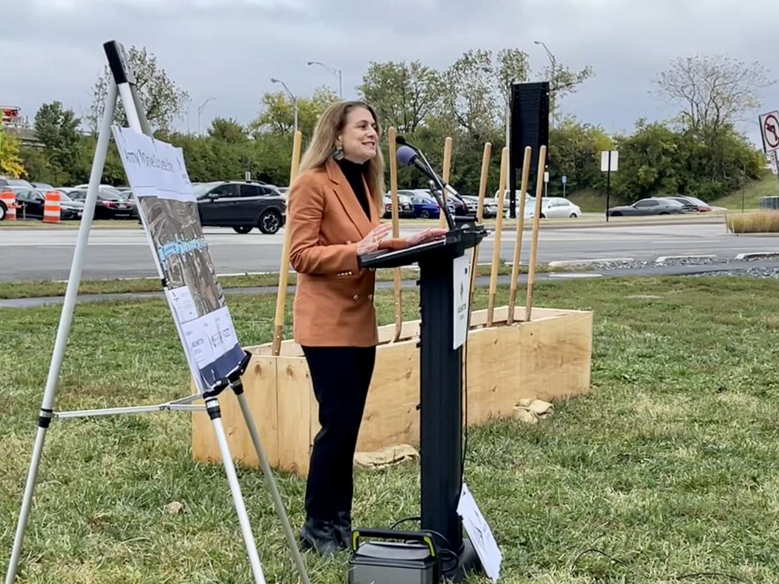
The County Board is set to vote this weekend on a contract to build a long-awaited pedestrian bridge.

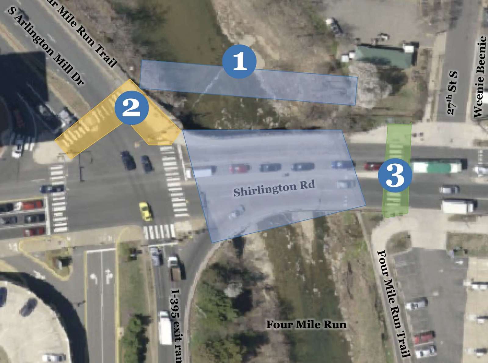
On Saturday, it is expected that the Arlington County Board will approve a $1.6 million contract to construct the Shirlington Road Pedestrian Bridge. The 15-foot-wide prefabricated steel bridge will run the length of Four Mile Run and parallel to the road with the purpose of providing safer bicycle and pedestrian access.

It will connect Shirlington and S. Arlington Mill Drive to Jennie Dean Park and the Green Valley neighborhood. It will also serve local users of the heavily-used Four Mile Run and W&OD trails nearby.

Work on the bridge could begin in the second half of this year if the contract is approved over the weekend, Arlington Dept. of Environmental Services spokesperson Claudia Pors told ARLnow. That would mean a completion date in mid to late 2024.

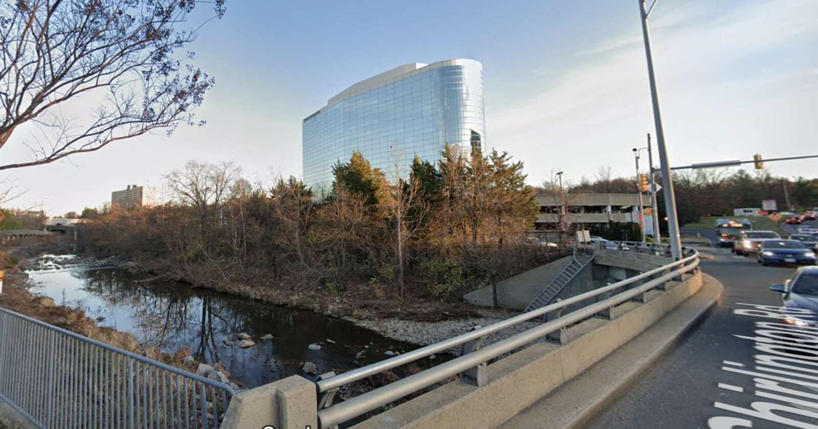
“The existing Shirlington Road vehicular bridge primarily funnels vehicles to/from I-395 and lacks safe, comprehensive accommodations for pedestrians and bicyclists traveling through this area,” the report to the Board says.

“This project will provide a key missing link in the County’s bicycle network by providing a north-south protected bicycle facility that will link up with the existing Four Mile Run Trail along South Arlington Mill Drive to the west and along Four Mile Run in the City of Alexandria to the east of the bridge,” the report adds.

The bridge has been under discussion for two decades and has been the topic of conversation among county staff and the public for years.

It will be constructed in two parts, per Pors. First, the span will be built offsite, a process that will take about nine months, while abutments will be added at S. Arlington Mill Drive and Jennie Dean Park where each end of the bridge will go. Around this time, the bridge’s walls will be built and the sidewalk and crosswalk at S. Arlington Mill Drive will be shuttered. Bike and pedestrian traffic will be detoured.

The bridge, then, will be lifted by a crane and installed.

“It’s possible that lanes on the existing bridge will close to accommodate this installation, and the public would be given notice of any detours,” Pors noted.

New street lighting on each end of the bridge will be installed as well, plus median, sidewalk and crosswalk retrofits. A new Rectangular Rapid Flashing Beacon will be installed in the median as well.

The work is set to be done by D.C.-based Milani Construction, whose $1.38 million bid (plus $277,000 in contingency costs) actually came in under the county engineer’s estimated construction cost.

Last year, work was completed on the parallel vehicle bridge on Shirlington Road. That included resurfacing, routine maintenance, widening the sidewalk by several feet on the west side of the bridge, widening curb ramps, and adding a median at the mid-block crosswalk near 27th Street S.

A number of these improvements came as a result of public feedback.

Additionally, the county is set to study the feasibility of adding another crossing at the intersection of S. Arlington Mill Drive and Shirlington Road.

“County staff have begun study efforts and anticipate reaching out to the public for input this fall,” Pors said.


(Updated at 3:25 p.m.) A public green space with a play area for kids is now open at Clarendon’s outdoor shopping center.

The Loop, a central green space in the middle of the Crossing Clarendon, officially opened on Friday, a spokesperson confirmed to ARLnow. Several readers sent tips and photos of locals enjoying themselves in the new public park at 2800 Clarendon Blvd late last week.

The new park includes walkways, Adirondack chairs, new landscaping and artificial turf, a pipe-like tunnel, small bronze-colored statues of hopping rabbits, and an enclosed play area for kids. It was become known as the Loop due to the quarter-mile piece of roadway that loops around the plaza and through the shopping center.

The almost cage-like play area extends vertically with red metal wavy structures for kids to climb as well as several exit and entrance points.

Dogs are allowed in the park, but “they are required to relieve themselves only in the designated areas, highlighted by the on-site signage,” the spokesperson said.

The park has been in the making for a while now.

It was first announced in early 2021 that property owner Regency Centers was looking into building a pedestrian-friendly plaza in the middle of the shopping center, which has an Apple Store, Pottery Barn, and Crate & Barrel. That spring, the entire mixed-use development was rebranded as The Crossing Clarendon.

Then, a year ago, plans were unveiled that showed some of what is now there. While the mock-ups and initial plans show that the end of the U-shaped road would be cut off from vehicular traffic to create a pedestrian-only area, that isn’t yet the case. Construction does appear to be continuing on the roadway, though.

“This area within The Crossing, known as The Loop, is a fresh look at how the community interacts with the center,” Regency Centers’ Vice President Andrew Kabat wrote in a statement. “The amenities, design, and layout were intentionally and considerately implemented to highlight what a unique location this is within the corridor, and a place for neighbors, shoppers, and friends to gather for a long time. This property was deserving of an updated face-lift, and we’re excited to provide more updates for The Crossing in the future.”

Hat tip to George Brazier


More signs preventing right turns at red lights are going up around Arlington County to reduce crashes.

They were added to long stretches of major arterial streets, including Columbia Pike and Wilson Blvd. The county has concurrently reprogrammed walk signals to give pedestrians a head start crossing the street.

These changes are being made to eliminate crashes that are fatal or result in serious injuries, the aim of its two-year-old traffic safety initiative known as Vision Zero.

“This is a win for pedestrian safety benefit,” said Chris Slatt, a member of Sustainable Mobility for Arlington, which has advocated for more of no-turn-on-red signs in areas with many pedestrians. “You would want to be safe to walk and not have to worry about driving through crosswalk.”

Some drivers have anecdotally reported congestion and longer idling times to ARLnow.

“Seems like these signs cause a lot of cars to sit and idle at intersections longer than they used to,” notes one tipster. “They also generally gum up traffic.”

County documents note there have been safety benefits seen in areas with high pedestrian volumes. Additionally, a focus group of elderly adults appreciated the red light restrictions.

The county’s view is that any reasonable trade-off is worth it.

“Although traffic may slightly increase at times due these safety interventions, the trade-off is a safer environment for our most vulnerable users — pedestrians and bicyclists,” Dept. of Environmental Services spokeswoman Katie O’Brien said.

During Vision Zero’s second year, per a report, the county has been adding no turn on red signs on:

  • Columbia Pike from the county line to Washington Blvd
  • Fairfax Drive from N. Glebe Road to N. Kirkwood Dr
  • Clarendon Blvd from N. Highland Street to Ft. Myer Drive and Wilson Blvd
  • Wilson Blvd from N. Glebe Road to Fort Myer Drive

Year 2 of Arlington’s Vision Zero plan wraps up this spring.

The county says it has also grown the number of signalized intersections with a 3-7 second head start for pedestrians from 31 to 77 during Year 2. Studies show this change can reduce pedestrian-vehicle collisions by up to 60%.

As of March 2022, the county had no-turn-on-red signs at 147 approaches — each point of an intersection — after adding signs at 35 approaches in Year 1 of Vision Zero, per a May report.

Priority intersections for these changes include those with many pedestrians and bicyclists, restricted sight distance and a history of turn-related crashes, according to a “Vision Zero toolkit” of traffic safety treatments.

Arlington joins other states and municipalities, including D.C., phasing out the right-on-red at busy intersections. A number of studies have shown right on red decreases safety and restrictions improve safety for pedestrians and cyclists.

Right on red was legalized 50 years ago to prevent idling and save gas during an oil embargo proclaimed by oil-exporting Arab countries, according to the county. The Energy Policy and Conservation Act of 1975 required states to allow right turns on red to receive certain federal funds.

“Unfortunately, the country has been experiencing the trade-offs of right on red turns ever since,” the county said in the Vision Zero toolkit.

(more…)


A high-traffic intersection one block north of Columbia Pike could get some safety upgrades, including a traffic signal.

Arlington County is embarking on a project to develop plans to upgrade the intersection of S. Glebe Road and 9th Street S., located between the Alcova Heights and Arlington Heights neighborhoods.

In addition to replacing a rapid-flash beacon with a traffic signal, the county says changes, in collaboration with the Virginia Dept. of Transportation, could include extending the curbs, updating the crosswalks and refuge medians, and fixing deteriorating ramps that do not comply with the Americans with Disabilities Act.

The forthcoming project responds to community feedback, a 2022 safety audit of Glebe Road — a VDOT-maintained artery — and a 2020 analysis of “crash hot spots,” according to a county webpage. The latter two reports include data, photos and community comments describing unsafe conditions for pedestrians, cyclists, transit users and drivers.

“Glebe Road from 14th Street N. to Columbia Pike is part of Arlington County’s High Injury Network,” the county says. “These corridors experience high concentrations of critical crashes compared to other corridors in Arlington.”

Per the safety audit, the intersection saw two pedestrian crashes and five left-turn vehicle crashes between January 2018 and February 2021. It also found that many people drive over the speed limit by at least 5 mph between 8th Street S. and 9th Street S., going an average of 38 mph.

“Community feedback received as part of the Vision Zero Action Plan development identified Glebe Road and 9th Street S. as an unsafe crossing,” the county said.

Arlington is working toward eliminating traffic-related serious injuries and deaths by 2030 as part of its initiative known as Vision Zero. Transportation advocates and the Arlington County Board called for swift action to realize plan goals and make roads safer after a rash of crashes involving pedestrians last year.

Some residents heralded the project on Twitter as sorely needed and a long time in coming.

Back in 2018, cyclists who participated in a “protest ride” to advocate for better cycling conditions, called specifically for improvements to 9th Street S., which is part of the Columbia Pike Bike Boulevards, a bicycle route parallel to the Pike.

https://twitter.com/ARLINGTONAF/status/1633545704135172096

This spring, there will be a public engagement opportunity in which the county will solicit feedback on existing conditions, including site constraints such as utility poles that block parts of the sidewalk.

County staff are preparing engagement materials, and “when that’s ready, the engagement will open,” Dept. of Environmental Services spokeswoman Claudia Pors said.

The engagement will first ask people to share how they currently use these streets as well as any ideas or concerns they have.

“This input will be used to refine to goals and develop concept options,” the webpage says.

This spring and summer, county staff will again request feedback on a concept plan, which will be incorporated into a final design plan that the county anticipates can be prepared this fall.

Arlington County has completed, started or has planned other transportation upgrades along Glebe Road, per the 2022 audit, including new or re-programmed traffic signals and new ramps.

Other projects on Glebe Road (via Arlington County)

Closed pedestrian bridge over Route 50 (via Arlington County)

A pedestrian bridge in the Rosslyn area is closed after inspectors founds something worrisome.

The bridge over Route 50, connecting N. Fairfax Drive and Fort Myer Drive in the Radnor-Fort Myer Heights neighborhood, was found to have deteriorating concrete in sections, according to Arlington County. The span is closed while crews work on repairs.

More from a county press release:

Engineers are closing the pedestrian bridge connecting North Fairfax Drive to Fort Myer Drive over Arlington Boulevard, effective immediately, as a result of a bridge inspection today, Thursday, December 8, out of an abundance of caution.

Pedestrian access over Arlington Boulevard will be maintained on the Rhodes Street bridge to the west and North Meade Street to the east.

The restrictions will stay in place until further notice. The Arlington Boulevard multi-use trail will remain open on the north side of the bridge.

Crews had been conducting maintenance work on the bridge’s surface. An inspection revealed deterioration of the concrete in some sections of the bridge. The bridge will be temporarily closed while crews work on these repairs.


Police officer talks with a driver during high-visibility enforcement along Little Falls Road (via ACPD)

(Updated at 4:10 p.m.) Police issued a traffic ticket every six minutes, on average, during an enforcement effort in front of Nottingham Elementary on Thursday afternoon.

The several block stretch of Little Falls Road near the school, in the Williamsburg neighborhood, has seen three fatal pedestrian crashes since 2014, including an elderly woman who was struck and killed by the driver of an SUV in October. That driver is not facing criminal charges.

Arlington County police conducted yesterday’s high-visibility enforcement as part of its Street Smart road safety campaign.

“During yesterday’s hour-long StreetSmart activation in the 5900 block of Little Falls Road, which coincided with school dismissal, officers issued 8 speeding citations and 2 citations for stop sign violations,” ACPD spokeswoman Ashley Savage tells ARLnow. “Drivers are reminded to slow down, be mindful of pedestrians and obey posted speed limits which change during school zone times and are indicated by flashing yellow lights.”

“Officers will continue to conduct periodic random, rotating enforcement in the area with the goal of compliance even when police are not present,” Savage noted. “Additionally, as part of our education efforts, police have deployed a variable message board on Little Falls Road with transportation safety messaging.”

Arlington’s Dept. of Environmental Services added that safety improvements are in the works for the intersection where October’s crash happened.

“In response to the recent tragic crash fatality at the intersection of Little Falls Rd and John Marshall Dr, the Vision Zero Critical Crash team has developed short-term safety improvements and enhancements for this intersection,” the department said in a brief statement. “We plan to install these improvements by the end of the year, weather permitting.”

More on the fall Street Smart campaign in Arlington, below, via an ACPD video.


Unmarked or temporarily marked crosswalks along Langston Blvd are slated to be painted today (Friday), weather permitting.

The repainting activity comes nearly two months after the Virginia Department of Transportation paved Langston Blvd from Washington Blvd to N. Glebe Road, in East Falls Church, and from Military Road to N. Kenmore Street, in Cherrydale, according to a paving map.

VDOT, which manages the road, finished the repaving projects at the start of September, as part of its annual road repaving and repainting schedule.

According to the state transportation department, the lag between paving and painting is not uncommon.

“As the line painting contractors are different than the milling/paving contractors, sometimes schedules don’t line up as smoothly,” VDOT spokeswoman Ellen Kamilakis tells ARLnow.

Arlington County and some residents tell ARLnow they have raised concerns about the lag with state transportation department.

“VDOT is aware of our concerns and are working to complete the markings on Langston Blvd,” Arlington Dept. of Environmental Services spokeswoman Katie O’Brien said.

The repainting comes while pedestrian safety occupies the minds of Arlington County Board members, local advocates and residents. In recent months, drivers struck and killed two pedestrians: one woman near Thomas Jefferson Middle School was killed by an alleged drunk driver and a woman near Nottingham Elementary School was killed in a crash, which police are still investigating.

While VDOT repaves state routes, Arlington County does take advantage of the state’s schedule to consider changes to the streets under its purview through its Resurfacing for Complete Streets program, O’Brien said.

“For roadways maintained by VDOT, Arlington does coordinate with VDOT on improvements,” she said. “For example, this year VDOT will be adding crossing enhancements on Langston Blvd at our request.”

These include high visibility crosswalk markings, advance yield signs and markings, she says.

She added that the county coordinated with the state to “upgrade the two uncontrolled crosswalks at the intersections of Langston Blvd and N. Oakland Street and Langston Blvd and N. Nelson Street, as well as marking all side streets with high-visibility crosswalks instead of standard crosswalks.”

On Langston Blvd between Military Road and N. Kenmore Street, VDOT will be installing bike lane skip marks through intersections, high-visibility crosswalks along side streets and additional directional markings, according to the county’s first annual Vision Zero report, released this spring.

Arlington County is a year and a half into its Vision Zero initiative that aims to eliminate traffic fatalities and serious injuries. Between January 2021 and March 2022, the county updated 238 crosswalks to high-visibility crosswalks, according to the report.

It also “added new warning signage, pavement yield and high visibility crosswalk markings, and other minor improvements at 12 multilane crossing locations,” after a review of multi-lane crossings, per an August newsletter.


Work to rebuild Army Navy Drive through Pentagon City and improve safety and transit along the corridor is officially underway.

This morning, Arlington County and the Northern Virginia Transportation Authority ceremonially broke ground on the long-planned Army Navy Drive “Complete Street” Project, which is intended to make the current multi-lane expanse of Army Navy Drive between S. Joyce Street and 12th Street S. more friendly to pedestrians, cyclists and transit users.

The project includes shortened pedestrian crossings, dedicated transit lanes between S. Joyce Street and S. Hayes Street, planted medians, new traffic signals at five intersections, and in some places, narrowed or reduced vehicle travel lanes. There will be a protected, two-way bicycle lane along the south side of Army Navy Drive.

Work kicks off as the number of workers and residents in the area is projected to significantly increase in the coming years. Amazon is preparing to build the second phase of its HQ2 — known as PenPlace, and which includes the iconic “Helix” building — at the corner of Army Navy Drive and S. Eads Street, while continuing to hire toward its goal of 25,000 employees. Meanwhile, JBG Smith has filed plans to add 1,668 residential units to surface parking lots at the nearby RiverHouse complex.

For the next three weeks, road users will see signs of crews setting up for the Army Navy Drive project, like cones and a construction management trailer, says Mark Dennis, project manager for Arlington’s Dept. of Environmental Services. In mid-November, people will start to see demolition work.

“Both sides of the corridors will have markings and indicators that the entire area is a working construction zone,” Dennis told ARLnow. “There will be slight changes in traffic patterns to accommodate lane shifts that are needed.”

He said drivers will need to pay extra attention to navigate these changes.

“Complete Streets” project plan for portion of Army Navy Drive (via Arlington County)

Before scooping ceremonial dirt with gold-colored shovels, local and regional dignitaries celebrated the expected benefits of the project.

Arlington County Board Chair Katie Cristol said the project will make Army Navy Drive safer for pedestrians and cyclists and more convenient for bus riders. It will also slow down drivers, improve air quality and reduce stormwater runoff, she said.

“It’s better for all of us because providing safe, accessible and multimodal transportation is a key part of the economic competitiveness of Pentagon City and Arlington overall,” said Cristol.

NVTA CEO Monica Backmon celebrated the project for “getting people out of their single-occupancy vehicles and giving people options.”

https://twitter.com/NVTAuthority/status/1584554450823544832

The transportation authority said in a press release that it has invested more than $227 million into transportation projects located in Pentagon City, Crystal City and Potomac Yard, known collectively as National Landing.

(more…)


N. Park Drive and N. George Mason Drive intersection near Lubber Run Community Center (image via Google Maps)

(Updated, 4:55 p.m.) A recent crash has renewed concerns about an intersection near the year-old Lubber Run Community Center.

For years, the intersection of N. Park Drive and N. George Mason Drive in the Arlington Forest neighborhood has been a source of worry for neighbors. The mix of speeding, four lanes, and a lack of a traffic signal have resulted in too many vehicle crashes, residents told ARLnow.

There have been 19 crashes at the intersection dating back to 2017, per data provided to ARLnow by the county’s Department of Environmental Services (DES). That includes one pedestrian-involved crash in 2018. None of the crashes resulted “in severe injury,” DES said.

A crash near the intersection of N. Park Drive and N. George Mason Drive (photo courtesy of David Hartogs)

But since the new Lubber Run Community Center opened in July 2021, the problem has only gotten worse. Nearly half of those crashes have happened in just the past 19 months, statistics from the Arlington County Police Department show.

That includes another crash earlier this week.

The county did add Rectangular Rapid Flashing Beacons (RRFBs) at the intersection in late 2020 as part of a transportation study related to the community center project.

“The intersection so far has not been identified as part of the Vision Zero High-Injury Network corridor or Hot Spot program,” DES said.

But this has not alleviated neighbors’ concerns. There’s a considerable worry that with increased pedestrian traffic, plus with Barrett Elementary School also nearby, it’s just a matter of time before a driver hits another pedestrian.

In other parts of the county, preventing pedestrian and bicyclists-involved crashes has been a significant ongoing concern amid a continued series of tragedies.

David Hartogs, who has lived in the townhomes across the street since 2005, told ARLnow he’s witnessed a “handful of crashes” and has heard at least another dozen at the intersection just over the last few years.

He recounted several of the crashes that stick in his mind most to ARLnow, including a car jumping a curb last spring, two accidents that resulted in vehicles ending up in the woods, and even a school bus “brushing” a motorcycle last November.

A school bus “brushing” a motorcycle at the intersection of N. Park Drive and N. George Mason Drive (photo courtesy of David Hartogs)

Earlier this week, Hartogs saw another crash and tweeted about his concern. As he noted on social media, he believes that there needs to be a traffic signal at that intersection and not just an RRFB.

He walks his kids to school and often thinks about their safety crossing that intersection.

(more…)


The proposed bridge between Crystal City and DCA at its starting point in the planned Virginia Railway Express station (courtesy of Arlington County)

It’s a little less park-like than New York City’s High Line, but Arlington County has come up with a concept for new pedestrian bridge from Crystal City to National Airport.

Now, it is asking people to share their feedback.

Over the past year, the county, the Virginia Department of Transportation and a Boston-based civil engineering firm have evaluated 16 possible bridge and tunnel connections across active train tracks, the GW Parkway and National Park Service land.

After concluding the site could not accommodate tunnel entrances, VDOT and the county were left to consider two bridges. Today (Tuesday), Arlington launched a public engagement period for a preferred alternative, moving the needle forward on what’s being called the Crystal City to Ronald Reagan Washington National Airport Multimodal Connection project — or CC2DCA.

The county proposes starting the bridge at the planned Virginia Railway Express Crystal City station at 2011 Crystal Drive  and ending in the second level of DCA’s Terminal 2 parking garage.

If built, it would take about five minutes to walk the 1,300 feet from the station to the airport, per a press release from the National Landing Business Improvement District.

The proposed Crystal City to DCA bridge starting point at the planned Virginia Railway Express station (courtesy of Arlington County)

The bridge would be an enclosed girder bridge running perpendicular to the rail tracks.

Then, the CC2DCA would run at an angle over the GW Parkway.

Initially, the county considered an arch bridge, but a bridge supported with girders would allow the county to link the connector with the Mount Vernon Trail without re-aligning it, per a staff presentation.

The bridge segment over the GW Parkway (courtesy of Arlington County)

Once it links up with DCA’s Terminal 2 parking garage, pedestrians would have a dedicated walkway through the garage to the terminal. This path would eliminate 40 parking spaces, according to the presentation.

The bridge segment over the GW Parkway and linking to DCA’s Terminal 2 parking garage (courtesy of Arlington County)

Ballpark estimates put the project at $43 million, the presentation said. So far, CC2DCA already has over $38 million in committed funds.

Now through Nov. 6, people can share their feedback in English, Spanish and Chinese, attend a public meeting on Tuesday, Oct. 25, or submit comments via email, according to the project webpage.

“The team is sharing concepts to make sure needs and priorities are aligned,” Dept. of Environmental Services spokeswoman Claudia Pors tells ARLnow. “This is the preferred recommended alternative to date, but it hasn’t been approved by any agencies as of now.”

After collecting public feedback, the county plans to present its recommendation to federal agencies in December, Pors said.

The preferred alternative could be confirmed by next spring and the design phase could start by the end of 2023, per the National Landing BID press release.

The second-place contender would have started at 2231 Crystal Drive and ended at the third level of the Terminal 2 parking garage. Staff ultimately decided against it because it was projected to cost $64.5 million, would eliminate 130 parking spaces at the airport and it would not be as centrally located for rail users, per the staff presentation.

(more…)


Dog poop, a lackluster park and imposing tower façades.

These are lingering concerns for some county commission members and residents who recently reviewed designs for two proposed apartment towers from JBG Smith in Crystal City.

The developer proposes building two towers with a total of 1,440 apartment units where the restaurant Jaleo (2250 Crystal Drive) used to be, and where an 11-story office building stands (223 23rd Street S). The new towers would have ground-floor retail and a parking garage underground.

Architects went back to the drawing board after a meeting in July to improve designs, and generally, these improvements were welcomed during a Site Plan Review Committee meeting last week.

Still, commissioners, community members and county staff said a planned interim park should be more vibrant — with ample amenities to separate dogs and their droppings from other visitors — and the towers should have more pedestrian-scale architecture, so that walking by does not feel claustrophobic and shady.

“I do hope there will be signs saying ‘This is not a dog park’ because people will try their hardest to use it as such,” said Ben D’Avanzo, a nearby resident representing the Aurora Highlands Civic Association, during the meeting on Thursday. “There’s only so much we can do to control that and prevent what happened at Met Park happens here.”

Before Amazon began rebuilding the park, Metropolitan Park was best known for being a large patch of grass where dogs from neighboring apartment buildings relieved themselves.

The 2010 Crystal City Sector Plan envisions three park spaces, totalling some 26,000 square feet, but one of those parks would require JBG Smith to redevelop apartments at 2221 S. Clark Street. In the interim, as part of this project, JBG Smith will create a temporary 8,000 square-foot park on the southwest corner of 223 23rd Street S.

Commissioners had also criticized initial designs for the park near JBG Smith’s planned towers for being “just a lawn,” said Planning Commissioner James Schroll during a meeting last week.

“Some of the concerns we received from you guys is that there may be foot traffic cutting through this lawn and there were concerns pet owners would use it for dog relief, and we didn’t really want that,” said Amanda Walker, with OJB Landscape Architecture.

Landscapers added pet relief areas and plantings around the park’s edges to prevent people from creating desire paths. The park is designed to allow for flexible, removable furniture to accommodate concerts, fitness classes and picnics and become a “destination for the community,” Walker said.

Before and after changes to designs for the interim open space at 223 23rd Street S. (via Arlington County)

“Right now, this looks good, but we’ve got lots of parks that look like this all over the area. It’s going to be hard to attract people to it in this interim period,” said Michael Dowell, representing the Crystal City Citizen Review Council. “If we really want to take a chance, let’s get some massive sculpture — that you can move…”

“… to the next interim park,” said Chris Slatt, representing the Transportation Commission at the SPRC meeting, completing Dowell’s sentence.

(more…)


View More Stories