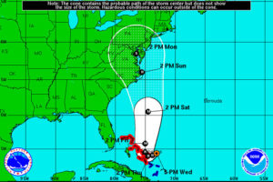
Possible path for Hurricane Joaquin (via National Weather Service)Gov. Terry McAuliffe has declared a state of emergency for Virginia in response to an impending nor’easter and Hurricane Joaquin, which is making its way toward the East Coast.

McAuliffe declared the state of emergency to allow Virginia businesses, residents and officials to prepare for the impending storms.

“I cannot stress enough the imperative for Virginians to focus on the rainstorms that are headed our way tomorrow and Friday, well before Hurricane Joaquin could potentially impact Virginia,” McAuliffe said in a statement. “The forecast of up to 10 inches of rain in areas across Virginia could result in floods, power outages and a serious threat to life and property. As we continue to track the path of Hurricane Joaquin, I have instructed the Secretary of Public Safety and Homeland Security to make every preparation for a major event Thursday and Friday.”

The nor’easter is expect to hit the area Thursday and Friday bringing a prolonged period of torrential rain and the potential for dangerous flooding, McAuliffe said in a statement. The rain may continue as Hurricane Joaquin approaches.

Joaquin is currently expected to make landfall at some point on Sunday, according to the National Weather Service.

The hurricane’s possible trajectory has it hitting North Carolina around 2 p.m. on Sunday and moving through Virginia, D.C. and Maryland Sunday and Monday. Another path, however, predicts Joaquin will bypass the East Coast completely.

Joaquin is currently a Category 1 hurricane with winds up to 85 miles per hour and is floating around the Bahamas and other Caribbean islands, according to NWS.

Virginia officials issued the following tips for staying safe when flooding is expected (after the jump).

(more…)


Flooding in Arlington on 9/8/11 (courtesy Brendan L.)A Flash Flood Warning has been issued for Arlington County and other D.C. area jurisdictions.

Forecasters say that a prolonged period of heavy rain is likely to cause flash flooding in some low-lying areas and along small streams.

The warning is in effect until 5:30 p.m., while a Flash Flood Watch will remain in effect through early Sunday morning.

From the National Weather Service:

THE NATIONAL WEATHER SERVICE IN STERLING VIRGINIA HAS ISSUED A

* FLASH FLOOD WARNING…

* UNTIL 530 PM EDT

* AT 232 PM EDT… MORE HEAVY RAIN IS MOVING OVER AN AREA THAT WILL TOLERATE LITTLE MORE BEFORE ROADS WILL BEGIN TO BECOME INUNDATED AND SMALL STREAMS WILL BEGIN TO RISE OUT OF THEIR BANKS. FLASH FLOODING IS EXPECTED TO BEGIN SHORTLY.

* SOME LOCATIONS THAT MAY EXPERIENCE FLOODING INCLUDE… ARLINGTON… ROCKVILLE… GAITHERSBURG… COLLEGE PARK… HERNDON… GREENBELT… FAIRFAX… VIENNA… FALLS CHURCH… BLADENSBURG… SPRINGFIELD… SOUTH RIDING… PIMMIT HILLS… MANTUA… DULLES INTERNATIONAL AIRPORT… GALLAUDET UNIVERSITY… NATIONALS PARK… CORAL HILLS… WOODBRIDGE AND BETHESDA.

PRECAUTIONARY/PREPAREDNESS ACTIONS…

TURN AROUND… DONT DROWN BY DRIVING INTO FLOODED ROADS OR ROADS THAT HAVE BEEN CLOSED.

BE VERY CAREFUL DRIVING AS SOME ROADS WILL BE CLOSED… AND LARGE PONDS OF WATER… EVEN ON LARGE INTERSTATES WILL INCREASE YOUR RISK OF LOOSING CONTROL OF YOUR VEHICLE. DRIVE SLOWLY.

WATCH YOUR KIDS TO ENSURE THEY DONT PLAY NEAR FLOOD WATERS.
IF YOU ARE IN A LOW AREA… OR NEAR A DRAINAGE DITCH OR SMALL STREAM… EXPECT RAPID RISES. STAY SAFE AND HEAD TO HIGHER GROUND IF NEEDED.


Rainfall over Arlington (Flickr pool photo by Jason OX4)

Record for Rainfall Set — A record amount of rain fell on Arlington yesterday. Reagan National Airport recorded 2.49 inches of rainfall, overtaking the previous record of 2.20 inches in 1907. [Washington Post]

Sun Gazette Endorses Fallon, Lander — The Arlington Sun Gazette newspaper has endorsed Peter Fallon and James Lander for the Democratic County Board nomination. The paper said Fallon can be “prickly” but has the “strongest community background,” while Lander can sometimes “wing it” on important matters but has “specific and out-of-the-box proposals.” [InsideNova]

Hynes Endorses Lander, Schneider — County Board Chair Mary Hynes has endorsed James Lander and Andrew Schneider ahead of the June 9 Democratic County Board primary. Hynes said Lander, the current chair of the Arlington School Board, is “the best partner on the School Board I’ve ever had.” She said she’s been “impressed with [Schneider’s] diligence and openness to different perspectives, new ideas.” [InsideNova]

New Rooftop Deck for Rosslyn Buildings — Rosslyn’s Twin Towers office building complex is getting a new rooftop deck. Located at 1100 Wilson Blvd, the 5,000 square foot terrace will feature sweeping views of the D.C. skyline, for use by tenants of the 31-story buildings. Tenants of the complex include WJLA and Politico. The terrace is expected to be completed by next spring. [Virginia Business]

Rise in New Catholic Priests — Following a national trend, the Catholic Diocese of Arlington is seeing a rise in the ordination of new priests. Bishop Paul Loverde is scheduled to ordain seven men to the local priesthood on Saturday, bringing the number of new priests ordained since 2012 to 20. [Catholic Diocese of Arlington]

No Big Buses on the Pike, Yet — There’s a reason why there are no articulated buses running down the Columbia Pike corridor, at least not yet. For one, standard bus service is sufficient at this time. Another reason: there’s no local storage space for big articulated buses. [Greater Greater Washington]

Arlington Students to Attend Governor’s School — Twenty Arlington Public Schools students will attend the prestigious Governor’s Schools or Governor’s Foreign Language Academy this summer. [Arlington Public Schools]

Flickr pool photo by Jason OX4


Arlington County and much of the surrounding region is under a Flood Watch tonight through Monday morning.

Forecasters say rain will start falling this evening and continue throughout the night, raising the possibility of flooding in flood-prone areas.

From the National Weather Service:

* FROM 7 PM EDT THIS EVENING THROUGH MONDAY MORNING

* MODERATE TO LOCALLY HEAVY RAIN WILL OVERSPREAD THE REGION THIS EVENING THROUGH TONIGHT… RAINFALL TOTALS AROUND ONE AND A HALF INCHES ARE EXPECTED ACROSS THE GREATER BALTIMORE-WASHINGTON METRO AREA. LOCALLY HIGHER AMOUNTS ARE POSSIBLE… ESPECIALLY ALONG AND IMMEDIATELY EAST OF THE BLUE RIDGE/CATOCTIN MOUNTAIN.

* EXPECT SMALL STREAMS AND CREEKS TO RISE… POSSIBLY OVERFLOWING THEIR BANKS. IN ADDITION… FLOODING MAY OCCUR IN LOW LYING AND POOR DRAINAGE AREAS.

PRECAUTIONARY/PREPAREDNESS ACTIONS…

A FLOOD WATCH MEANS THERE IS A POTENTIAL FOR FLOODING BASED ON CURRENT FORECASTS.

PLEASE MONITOR LATER FORECASTS AND BE ALERT FOR POSSIBLE FLOOD WARNINGS. THOSE LIVING IN AREAS PRONE TO FLOODING SHOULD BE PREPARED TO TAKE ACTION SHOULD FLOODING DEVELOP.


2013 Clarendon Mardi Gras paradeThe Clarendon-Courthouse Mardi Gras Parade is still on tonight despite the rain and despite Mardi Gras having happened three weeks ago.

The parade is scheduled to start at 8:00 p.m. on N. Barton Street. About 30 floats and assorted groups are currently expected take part in the roughly half-hour-long event, which will run up Wilson Blvd to N. Irving Street.

Last year the parade was postponed due to a snowstorm, before being cancelled altogether due to another snowstorm. This year the parade was originally scheduled for Feb. 17, but was again postponed due to snow.

Matt Hussmann, executive director of the Clarendon Alliance, which organizes the parade, said that he’d rather march in some rain than chance another parade-less year.

“It’s not raining hard,” he said. “What are the odds that if we postpone it again that it’s going to be any better?”

Hussmann said the parade has received a handful of cancellations from scheduled participants, including the beloved Ballou High School Marching Band. Still, Hussmann was optimistic for a good turnout and said the cancellations wouldn’t rain on his parade.

“It’s going to be a good crowd and we’re hoping as many people come out as [possible],” he said. “It should be fun.”

Arlington County Police say they’re planning the following parade-related road closures tonight:

  • Wilson Boulevard from Veitch Street to Barton Street will be closed from 6:45 p.m. to 9:30 p.m.
  • Adams Street and Wayne Street, between Clarendon Boulevard and Wilson Boulevard, will be closed from 6:45 p.m. to 9:30 p.m.
  • Wilson Boulevard from Barton Street to Irving Street will be closed from 7:45 p.m. to 9:30 p.m.

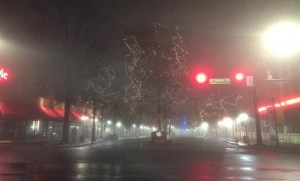
Dense fog in Shirlington in January 2014 (photo courtesy @SBDSLLC)Rudolph may need to get to work a bit early. Dense fog today, soaking rain tomorrow and gusty winds on Thursday are expected to make getting to grandma’s house for the holidays a bit trickier.

Four out of ten D.C. area residents — nearly 2.5 million people — are expected to travel 50 miles or more during the 13-day holiday travel period around Christmas and New Year’s, according to AAA Mid-Atlantic.

That’s up 3.3 percent from 2013.

Most of those travelers will be taking to the roads — 91 percent — while 5 percent will be flying and 4 percent will be traveling via other modes of transportation, AAA said. The busiest day on the roads: today, Dec. 23.

The weather is already making travel more difficult. Departure delays ranging from 30 minutes to 2 hours, due to fog, are being reported for flights going to eastern seaboard cities like Boston, New York and Philadelphia.

While the 24th and 25th are expected to be lighter travel days, it’s yet to be seen what impacts the expected wind and rain may have.

Locally, forecasters say to expect the fog to linger through this evening. From the National Weather Service:

… PATCHY DENSE FOG INTO EARLY AFTERNOON…

PATCHY DENSE FOG WILL CONTINUE TO DEVELOP ACROSS PORTIONS OF EASTERN AND SOUTHERN MARYLAND AND NORTHERN VIRGINIA LATE THIS MORNING. LOW CLOUDS ACROSS THE AREA WILL CONTINUE TO LOWER IN HEIGHT TOWARD THE SURFACE… REDUCING VISIBILITIES TO NEAR OR BELOW A QUARTER MILE IN LOCALIZED AREAS.

IF TRAVELING… USE EXTRA CAUTION AND BE PREPARED FOR QUICKLY REDUCED VISIBILITIES IN FOG.

Photo courtesy @SBDSLLC


Woman walks through the wind and rain caused by Hurricane Irene (file photo)Today’s sunny and unseasonable warm weather will give way to wind, rain and some strong storms Wednesday.

An approaching cold front will bring the potential for flooding and damaging winds, according to forecasters. Some higher-elevation areas to our west are under a wind advisory starting at 6:00 tonight.

This afternoon, the National Weather Service issued the following advisory for the D.C. area.

A STRONG COLD FRONT WILL IMPACT THE REGION WEDNESDAY INTO EARLY THURSDAY. THE POTENTIAL EXISTS FOR HEAVY RAINFALL AND FLOODING ACROSS THE OUTLOOK AREA. IN ADDITION…A FEW STRONG THUNDERSTORMS CAPABLE OF PRODUCING DAMAGING WIND GUSTS WILL BE POSSIBLE WEDNESDAY AND WEDNESDAY NIGHT.

MINOR COASTAL FLOODING IS LIKELY ALONG THE WESTERN SHORE OF THE CHESAPEAKE BAY AND TIDAL POTOMAC RIVER WEDNESDAY INTO THURSDAY. MODERATE COASTAL FLOODING IS ALSO POSSIBLE AT SENSITIVE SITES WEDNESDAY AND WEDNESDAY NIGHT.

A SMALL CRAFT ADVISORY IS IN EFFECT FOR THE ENTIRE MARYLAND PORTION OF THE CHESAPEAKE BAY AND TIDAL POTOMAC RIVER WEDNESDAY…AND WILL LIKELY NEED TO BE EXTENDED INTO WEDNESDAY NIGHT. GALES ARE ALSO POSSIBLE WEDNESDAY AND WEDNESDAY NIGHT.


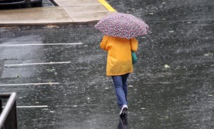
Pedestrians brave heavy rains in Courthouse (file photo)A Flood Watch is in effect tonight for Arlington and the rest of the D.C. region.

Forecasters say heavy, drenching rain is moving up from the south in the form of a nor’easter. The storm may produce localized flooding in low-lying areas through early Thursday.

From the National Weather Service:

… FLOOD WATCH REMAINS IN EFFECT FROM 6 PM EDT THIS EVENING THROUGH LATE TONIGHT…

THE FLOOD WATCH CONTINUES FOR

* PORTIONS OF MARYLAND… THE DISTRICT OF COLUMBIA AND NORTHERN VIRGINIA… INCLUDING THE FOLLOWING AREAS… IN MARYLAND… ANNE ARUNDEL… HARFORD… BALTIMORE… HOWARD… MONTGOMERY… AND PRINCE GEORGES. THE DISTRICT OF COLUMBIA. IN NORTHERN VIRGINIA… ARLINGTON/FALLS CHURCH/ALEXANDRIA AND FAIRFAX.

* FROM 6 PM EDT THIS EVENING THROUGH LATE TONIGHT

* LOW PRESSURE APPROACHING FROM THE SOUTHERN ATLANTIC STATES WILL BRING PERIODS OF MODERATE TO HEAVY RAIN ACROSS PORTIONS OF THE AREA LATE THIS EVENING AND CONTINUE OVERNIGHT. ONE TO TWO INCHES OF RAIN WITH LOCALLY HIGHER AMOUNTS ARE EXPECTED BY EARLY THURSDAY.

* PERSISTENT MODERATE TO LOCALLY HEAVY RAIN MAY CAUSE FLOODING OF LOW LYING AREAS… ESPECIALLY IN URBAN AREAS AND LOCATIONS PRONE TO FRESHWATER FLOODING. NEVER CROSS ROADS THAT ARE FLOODED. TURN AROUND DON’T DROWN.

PRECAUTIONARY/PREPAREDNESS ACTIONS…

A FLOOD WATCH MEANS THERE IS A POTENTIAL FOR FLOODING BASED ON CURRENT FORECASTS.

YOU SHOULD MONITOR LATER FORECASTS AND BE ALERT FOR POSSIBLE FLOOD WARNINGS. THOSE LIVING IN AREAS PRONE TO FLOODING SHOULD BE PREPARED TO TAKE ACTION SHOULD FLOODING DEVELOP.


Arlington and the surrounding area is now under a Flash Flood Warning.

The Flash Flood Warning means that sudden, localized flooding is imminent due to the heavy rains overnight. If you encounter a flooded roadway while driving, you’re strongly encouraged to “turn around, don’t drown.”

THE NATIONAL WEATHER SERVICE IN STERLING VIRGINIA HAS ISSUED A

* FLASH FLOOD WARNING FOR… THE DISTRICT OF COLUMBIA… SOUTHEASTERN MONTGOMERY COUNTY IN CENTRAL MARYLAND… CITY OF FAIRFAX IN NORTHERN VIRGINIA… CITY OF FALLS CHURCH IN NORTHERN VIRGINIA… ARLINGTON COUNTY IN NORTHERN VIRGINIA… CITY OF ALEXANDRIA IN NORTHERN VIRGINIA… EASTERN FAIRFAX COUNTY IN NORTHERN VIRGINIA…

* UNTIL 1015 AM EDT

* AT 709 AM EDT… NATIONAL WEATHER SERVICE DOPPLER RADAR INDICATED VERY HEAVY RAIN HAD FALLEN CAPABLE OF PRODUCING FLASH FLOODING. RADAR ESTIMATES THAT UP TO 3 INCHES OF RAIN HAVE ALREADY FALLEN ACROSS PORTIONS OF THE WARNED AREA. STREAMS ARE RISING EXTREMELY RAPIDLY.

* SOME LOCATIONS THAT ARE AFFECTED BY THE HEAVY RAIN INCLUDE ALEXANDRIA… ANNANDALE… ARLINGTON… BALLSTON… BELLE HAVEN… BURKE… FRANCONIA… HYBLA VALLEY… LAKE BARCROFT… LINCOLNIA… MCLEAN… MERRIFIELD… OAKTON… REAGAN NATIONAL AIRPORT… ROSSLYN… SPRINGFIELD… THE I395 AND I495 INTERCHANGE… THE I66 AND I495 INTERCHANGE… TYSONS CORNER… VIENNA… WOLF TRAP… ASPEN HILL… BETHESDA… CHEVY CHASE… COLESVILLE… FAIRLAND… HILLANDALE… POTOMAC… ROCKVILLE… TAKOMA PARK… THE AMERICAN LEGION BRIDGE… THE WOODROW WILSON BRIDGE… WHITE OAK… ADAMS MORGAN… AMERICAN UNIVERSITY… GEORGETOWN… DOWNTOWN WASHINGTON… US CAPITOL… CRYSTAL CITY… FORT TOTTEN… GALLAUDET UNIVERSITY… GROVETON… HOWARD UNIVERSITY… HUNTINGTON… MANTUA… NATIONALS PARK AND PIMMIT HILLS.

EXCESSIVE RUNOFF FROM HEAVY RAINFALL WILL CAUSE FLASH FLOODING OF SMALL CREEKS AND STREAMS… URBAN AREAS… HIGHWAYS… STREETS… UNDERPASSES AND OTHER DRAINAGE AREAS AND LOW LYING SPOTS.

MOST FLASH FLOOD DEATHS OCCUR IN AUTOMOBILES. NEVER DRIVE YOUR VEHICLE INTO AREAS WHERE WATER COVERS THE ROAD. FLOODWATER USUALLY IS DEEPER THAN IT APPEARS. JUST ONE FOOT OF FLOWING WATER IS POWERFUL ENOUGH TO SWEEP VEHICLES OFF THE ROAD. MAKE THE SMART CHOICE WHEN FLOODED ROADS ARE ENCOUNTERED… TURN AROUND… DONT DROWN.


The National Weather Service has issued a Flash Flood Watch for Arlington and the surrounding D.C. region.

Forecasters say 2-3 inches of rain is expected to fall from Thursday afternoon into Friday. Heavy rain showers and thunderstorms may cause flash flooding, especially along small local rivers and streams.

From the NWS:

… FLASH FLOOD WATCH IN EFFECT FROM LATE THURSDAY NIGHT THROUGH FRIDAY AFTERNOON…

THE NATIONAL WEATHER SERVICE IN STERLING VIRGINIA HAS ISSUED A

* FLASH FLOOD WATCH FOR PORTIONS OF MARYLAND… THE DISTRICT OF COLUMBIA AND VIRGINIA… INCLUDING THE FOLLOWING AREAS… IN MARYLAND… ANNE ARUNDEL… CARROLL… CHARLES… FREDERICK MD… HARFORD… HOWARD… MONTGOMERY… NORTHERN BALTIMORE… PRINCE GEORGES AND SOUTHERN BALTIMORE. THE DISTRICT OF COLUMBIA. IN VIRGINIA… ALBEMARLE… ARLINGTON/FALLS CHURCH/ALEXANDRIA… CULPEPER… FAIRFAX… GREENE… LOUDOUN… MADISON… NELSON… NORTHERN FAUQUIER… ORANGE… PRINCE WILLIAM/MANASSAS/MANASSAS PARK… RAPPAHANNOCK… SOUTHERN FAUQUIER… SPOTSYLVANIA AND STAFFORD.

* FROM LATE THURSDAY NIGHT THROUGH FRIDAY AFTERNOON

* SHOWERS AND THUNDERSTORMS… WITH PERIODS OF HEAVY RAIN… ARE EXPECTED TO DEVELOP THURSDAY AFTERNOON AND CONTINUE THROUGH FRIDAY MORNING. 2 TO 3 INCHES OF RAINFALL IS EXPECTED… WITH LOCALLY HIGHER AMOUNTS. FLASH FLOODING IS POSSIBLE… ESPECIALLY ALONG SMALL RIVERS AND STREAMS.

PRECAUTIONARY/PREPAREDNESS ACTIONS…

A FLASH FLOOD WATCH MEANS THAT CONDITIONS MAY DEVELOP THAT LEAD TO FLASH FLOODING. FLASH FLOODING IS A VERY DANGEROUS SITUATION.

YOU SHOULD MONITOR LATER FORECASTS AND BE PREPARED TO TAKE ACTION SHOULD FLASH FLOOD WARNINGS BE ISSUED.


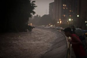
Flooded Four Mile Run (photo courtesy @gogogaryo)A Flash Flood Warning has been issued for Arlington and much of the rest of the D.C. region. The National Weather Service warns that nearly 3 inches of rain has fallen already today and more heavy rainfall is on the way.

Standing water on roadways has created some dangerous driving conditions in Arlington, and swollen local waterways like Four Mile Run are starting to resemble “class three rapids,” but otherwise few serious problems have been reported around the county so far.

It’s a different story elsewhere in the region. In Montgomery County, cars and their drivers are getting trapped in high standing water.

From the National Weather Service:

THE NATIONAL WEATHER SERVICE IN STERLING VIRGINIA HAS ISSUED A

* FLASH FLOOD WARNING…

* UNTIL 415 PM EDT

* AT 117 PM EDT… NATIONAL WEATHER SERVICE DOPPLER RADAR INDICATED VERY HEAVY RAIN CAPABLE OF PRODUCING FLASH FLOODING. UP TO THREE INCHES OF RAIN HAS FALLEN IN THE LAST 24 HOURS. ADDITIONAL RAINFALL AMOUNTS OF UP TO 1 INCH CAN BE EXPECTED.

* SOME LOCATIONS THAT ARE AFFECTED BY THE HEAVY RAIN INCLUDE ANNANDALE… ARLINGTON… BALLSTON… BULL RUN… BURKE… CENTREVILLE… CHANTILLY… DALE CITY… GREAT FALLS… HERNDON… LAKE BARCROFT… LAKE RIDGE… LINCOLNIA… MCLEAN… MERRIFIELD… OAKTON… RESTON… ROSSLYN… SPRINGFIELD… THE I395 AND I495 INTERCHANGE… THE I66 AND I495 INTERCHANGE… TYSONS CORNER… VIENNA… WOLF TRAP… BETHESDA… CHEVY CHASE… POTOMAC… TAKOMA PARK… THE AMERICAN LEGION BRIDGE… ADAMS MORGAN… AMERICAN UNIVERSITY… GEORGETOWN… MANTUA AND PIMMIT HILLS.

MOST FLASH FLOOD DEATHS OCCUR IN AUTOMOBILES. NEVER DRIVE YOUR VEHICLE INTO AREAS WHERE WATER COVERS THE ROAD. FLOODWATER USUALLY IS DEEPER THAN IT APPEARS. JUST ONE FOOT OF FLOWING WATER IS POWERFUL ENOUGH TO SWEEP VEHICLES OFF THE ROAD. MAKE THE SMART CHOICE WHEN FLOODED ROADS ARE ENCOUNTERED… TURN AROUND… DONT DROWN.

Photo courtesy @gogogaryo


View More Stories