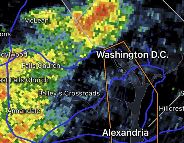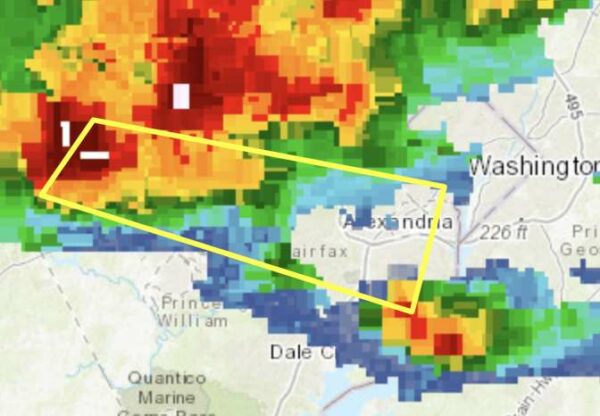
Weather radar as of 5:10 p.m. (via National Weather Service)

Northern portions of Arlington County are now under a Severe Thunderstorm Warning.

A line of strong storms is approaching the area and may pack damaging wind gusts.

More from the National Weather Service:

BULLETIN – IMMEDIATE BROADCAST REQUESTED
Severe Thunderstorm Warning
National Weather Service Baltimore MD/Washington DC
502 PM EDT Mon Jun 21 2021

The National Weather Service in Sterling Virginia has issued a

* Severe Thunderstorm Warning…

* Until 545 PM EDT.

* At 501 PM EDT, severe thunderstorms were located along a line extending from Ballenger Creek to Leesburg to near The Plains, moving east at 35 mph.

HAZARD…60 mph wind gusts.

SOURCE…Radar indicated.

IMPACT…Damaging winds will cause some trees and large branches to fall. This could injure those outdoors, as well as damage homes and vehicles. Roadways may become blocked by downed trees. Localized power outages are possible. Unsecured light objects may become projectiles.

* Locations impacted include… Arlington, Columbia, Germantown, Centreville, Rockville, Bethesda, Gaithersburg, Reston, Leesburg, Annandale, Olney, Springfield, South Riding, Herndon, Fairfax, Vienna, Damascus, Falls Church, Broadlands and Lansdowne.


Update at 5:10 p.m. — A Severe Thunderstorm Warning has now been issued.

Update at 2:20 p.m. — A Severe Thunderstorm Watch has now been issued for Arlington and much of the region.

Earlier: Strong storms may roll through the area between 5-7 p.m. this evening.

The National Weather Service released a Special Weather Statement this afternoon, warning of the potential for damaging wind gusts, large hail and perhaps even an isolated tornado.

More from NWS:

108 PM EDT MON JUN 21 2021

…SEVERE THUNDERSTORM POTENTIAL THIS AFTERNOON AND EVENING…

A LINE OF STRONG TO SEVERE THUNDERSTORMS WITH DAMAGING WIND GUSTS IS EXPECTED TO SWEEP EAST ACROSS OUR REGION THIS AFTERNOON INTO THIS EVENING.

THE RISK FOR SEVERE THUNDERSTORMS INCREASES FROM MARGINAL RISK OVER CENTRAL VIRGINIA, TO SLIGHT RISK GENERALLY NORTH OF I-66 AND US-50, TO ENHANCED RISK ALONG AND NEAR THE MASON-DIXON LINE. DAMAGING WIND GUSTS ARE THE PRIMARY THREAT, ALTHOUGH LARGE HAIL AND AN ISOLATED TORNADO ARE ALSO POSSIBLE.

THE INITIAL LINE OF STORMS SHOULD ENTER WESTERN MARYLAND AND THE EASTERN PANHANDLE OF WEST VIRGINIA BETWEEN 1 AND 4 PM. IT IS THEN EXPECTED TO MOVE EAST ACROSS THE SHENANDOAH VALLEY AND WEST CENTRAL MARYLAND BETWEEN 3 AND 5 PM. THE LINE SHOULD REACH THE BALTIMORE AND WASHINGTON METRO AREAS AND SOUTHERN MD BETWEEN 5 AND 8 PM. ALL TIMES ARE CURRENT BEST ESTIMATES, AND PEOPLE SHOULD BE READY TO SEEK SHELTER WHEN STORMS THREATEN OR WARNINGS ARE ISSUED.


Update at 10:50 p.m. — The earlier Flash Flood Watch has been upgraded to a Flash Flood Warning. Flooding near streams and in low-lying areas is imminent. The warning is in effect until 1:45 a.m.

From the National Weather Service:

* AT 1049 PM EDT, DOPPLER RADAR INDICATED THUNDERSTORMS PRODUCING HEAVY RAIN ACROSS THE WARNED AREA. BETWEEN 1 AND 2 INCHES OF RAIN HAVE FALLEN. FLASH FLOODING IS ONGOING OR EXPECTED TO BEGIN SHORTLY.

HAZARD…LIFE THREATENING FLASH FLOODING. THUNDERSTORMS PRODUCING FLASH FLOODING.

SOURCE…DOPPLER RADAR.

IMPACT…LIFE THREATENING FLASH FLOODING OF CREEKS AND STREAMS, URBAN AREAS, HIGHWAYS, STREETS AND UNDERPASSES.

* SOME LOCATIONS THAT MAY EXPERIENCE FLASH FLOODING INCLUDE… ARLINGTON… ALEXANDRIA… CENTREVILLE… ROCKVILLE… BETHESDA… RESTON… BOWIE… ANNANDALE… CLINTON… SPRINGFIELD… COLLEGE PARK… SOUTH RIDING… FORT WASHINGTON… HERNDON… GREENBELT… FAIRFAX… LANGLEY PARK… BELTSVILLE… FORT HUNT… VIENNA…

PRECAUTIONARY/PREPAREDNESS ACTIONS…

TURN AROUND, DON’T DROWN WHEN ENCOUNTERING FLOODED ROADS. MOST FLOOD DEATHS OCCUR IN VEHICLES.

A FLASH FLOOD WARNING MEANS THAT FLOODING IS IMMINENT OR OCCURRING. IF YOU ARE IN THE WARNED AREA MOVE TO HIGHER GROUND IMMEDIATELY. RESIDENTS LIVING ALONG STREAMS AND CREEKS SHOULD TAKE IMMEDIATE PRECAUTIONS TO PROTECT LIFE AND PROPERTY.

Update at 10:40 p.m. — The county is also under a Flash Flood Watch due to heavy downpours.

1025 PM EDT MON JUN 14 2021

…FLASH FLOOD WATCH IN EFFECT UNTIL 2 AM EDT TUESDAY…

THE NATIONAL WEATHER SERVICE IN STERLING VIRGINIA HAS ISSUED A

* FLASH FLOOD WATCH FOR PORTIONS OF DC…MARYLAND AND NORTHERN VIRGINIA, INCLUDING THE FOLLOWING AREAS: IN DC, DISTRICT OF COLUMBIA. IN MARYLAND, ANNE ARUNDEL, CENTRAL AND SOUTHEAST MONTGOMERY, CHARLES AND PRINCE GEORGES. IN NORTHERN VIRGINIA, ARLINGTON/FALLS CHURCH/ALEXANDRIA AND FAIRFAX.

* UNTIL 2 AM EDT TUESDAY

* THUNDERSTORMS WITH INTENSE RAINFALL WILL CAUSE RAINFALL AMOUNTS AROUND 1-2 INCHES IN LOCALIZED AREAS WITHIN AN HOUR.

* HEAVY RAIN IN SHORT PERIODS OF TIME WILL CAUSE THE POTENTIAL FOR STREAMS AND CREEKS TO QUICKLY RISE OUT OF THEIR BANKS AS WELL AS THE POTENTIAL FOR FLASH FLOODING IN URBAN AREAS.

PRECAUTIONARY/PREPAREDNESS ACTIONS…

A FLASH FLOOD WATCH MEANS THAT CONDITIONS MAY DEVELOP THAT LEAD TO FLASH FLOODING. FLASH FLOODING IS A VERY DANGEROUS SITUATION. YOU SHOULD MONITOR LATER FORECASTS AND BE PREPARED TO TAKE ACTION SHOULD FLASH FLOOD WARNINGS BE ISSUED.

Update at 10:35 p.m. — The remainder of Arlington is now under a Severe Thunderstorm Warning.

Update at 10:15 p.m. — A portion of Arlington is now under a Severe Thunderstorm Warning as a line of storms approach.

From the National Weather Service:

1011 PM EDT MON JUN 14 2021

THE NATIONAL WEATHER SERVICE IN STERLING VIRGINIA HAS ISSUED A

* SEVERE THUNDERSTORM WARNING…

* UNTIL 1100 PM EDT.

* AT 1011 PM EDT, A SEVERE THUNDERSTORM WAS LOCATED NEAR SOUTH RIDING, MOVING EAST AT 35 MPH.

HAZARD…60 MPH WIND GUSTS.

SOURCE…RADAR INDICATED.

IMPACT…DAMAGING WINDS WILL CAUSE SOME TREES AND LARGE BRANCHES TO FALL. THIS COULD INJURE THOSE OUTDOORS, AS WELL AS DAMAGE HOMES AND VEHICLES. ROADWAYS MAY BECOME BLOCKED BY DOWNED TREES. LOCALIZED POWER OUTAGES ARE POSSIBLE. UNSECURED LIGHT OBJECTS MAY BECOME PROJECTILES.

* LOCATIONS IMPACTED INCLUDE… ARLINGTON, ALEXANDRIA, CENTREVILLE, ANNANDALE, SPRINGFIELD, SOUTH RIDING, FAIRFAX, VIENNA, GROVETON, FALLS CHURCH, HUNTINGTON, MANTUA, FORT BELVOIR, BURKE, OAKTON, CHANTILLY, LINCOLNIA, FRANCONIA, MERRIFIELD AND NEWINGTON.

PRECAUTIONARY/PREPAREDNESS ACTIONS…

FOR YOUR PROTECTION MOVE TO AN INTERIOR ROOM ON THE LOWEST FLOOR OF A BUILDING.

Earlier: Arlington and the D.C. area is under a Severe Thunderstorm Watch until 2 a.m.

Strong storms are expected across the region tonight, potentially packing winds gusts that can down trees and power lines.

More from the National Weather Service:

A SEVERE THUNDERSTORM WATCH IS IN EFFECT FOR THE ENTIRE AREA UNTIL 2 AM. DAMAGING WIND GUSTS AND LARGE HAIL ARE THE PRIMARY THREATS, AND AN ISOLATED TORNADO IS POSSIBLE.

AN ISOLATED INSTANCE OF FLASH FLOODING IS POSSIBLE THIS EVENING DUE TO HEAVY RAINFALL ASSOCIATED WITH THUNDERSTORMS.

Flickr pool photo by John Sonderman
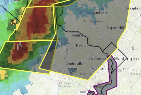

Storms on radar at 12:35 p.m.

A portion of Arlington County is now under a Severe Thunderstorm Warning as a line of potent storms bears down on the area.

The warning encompasses a southern portion of the county.

From the National Weather Service:

BULLETIN – IMMEDIATE BROADCAST REQUESTED
SEVERE THUNDERSTORM WARNING
NATIONAL WEATHER SERVICE BALTIMORE MD/WASHINGTON DC
1236 PM EDT FRI JUN 4 2021

THE NATIONAL WEATHER SERVICE IN STERLING VIRGINIA HAS ISSUED A

* SEVERE THUNDERSTORM WARNING…

* UNTIL 115 PM EDT.

* AT 1236 PM EDT, A SEVERE THUNDERSTORM WAS LOCATED OVER MANTUA, MOVING SOUTHEAST AT 20 MPH.

HAZARD…60 MPH WIND GUSTS AND QUARTER SIZE HAIL.

SOURCE…RADAR INDICATED.

IMPACT…DAMAGING WINDS WILL CAUSE SOME TREES AND LARGE BRANCHES TO FALL. THIS COULD INJURE THOSE OUTDOORS, AS WELL AS DAMAGE HOMES AND VEHICLES. ROADWAYS MAY BECOME BLOCKED BY DOWNED TREES. LOCALIZED POWER OUTAGES ARE POSSIBLE. UNSECURED LIGHT OBJECTS MAY BECOME PROJECTILES.

* LOCATIONS IMPACTED INCLUDE… ARLINGTON, ALEXANDRIA, ANNANDALE, CLINTON, SPRINGFIELD, FORT WASHINGTON, FORT HUNT, VIENNA, GROVETON, FORESTVILLE, FALLS CHURCH, HUNTINGTON, MANTUA, FORT BELVOIR, NATIONAL HARBOR, REAGAN NATIONAL AIRPORT, CRYSTAL CITY, ANDREWS AIR FORCE BASE, BURKE AND LINCOLNIA.

PRECAUTIONARY/PREPAREDNESS ACTIONS…

FOR YOUR PROTECTION MOVE TO AN INTERIOR ROOM ON THE LOWEST FLOOR OF A
BUILDING.


Arlington County and the D.C. area is under a Severe Thunderstorm Watch tonight.

The watch is in effect until 9 p.m. Forecasters say strong storms packing quarter-sized hail and strong winds are possible.

“The main threat is damaging wind gusts, though a tornado cannot be ruled out,” the National Weather Service says.

More from NWS:


Progress on Revamped VRE Station — “It could just be just a matter of months until the Virginia Railway Express plan to create a new station in Crystal City reaches another milestone. VRE officials project it will be in the third quarter of 2021 that preliminary engineering and environmental-impact steps toward eventual construction will be completed.” [Sun Gazette]

Amazon Sponsoring Arlington Youth Soccer — “Kids in Arlington’s travel soccer programs will play with the Amazon logo on the backs of their jerseys this fall thanks to a sponsorship between the retailing giant and the Arlington Soccer Association.” [Washingtonian]

Board Mulls Police Oversight — “Throughout June and July, the Board will consider different models of a Civilian Review Board with the goal of creating a CRB and Independent Policing Auditor function that can enhance community trust in and collaboration with the Arlington County Police Department… In the coming weeks, the County Board will be studying these models, as well as others from around the Commonwealth and country, and encourages community members to provide their feedback and perspectives on the different models.” [Arlington County]

Storms Expected Today — “Strong to severe thunderstorms are possible Thursday afternoon and evening across the DMV, with strong to locally damaging winds being the main threat. The National Weather Service Storm Prediction Center has the region at a Level 2 out of 5 slight risk for severe weather.” [Washington Post, Twitter]


Update at 8:25 p.m. — Now the remainder of Arlington is under another Severe Thunderstorm Warning.

Update at 8:10 p.m. — Another Severe Thunderstorm Warning has been issued, this time until 8:45 p.m.

The warning covers portions of North Arlington. The storms earlier this evening caused some damage, including downed tree branches and power lines, primarily in middle and southern portions of the county.

Earlier: Arlington is now under a Severe Thunderstorm Warning as a line of strong storms nears the county.

(more…)


Arlington County and much of the region is now under a Severe Thunderstorm Watch.

The watch is in effect until 10 p.m. tonight. Forecasters say strong storms with damaging winds are possible this afternoon and tonight.

From the National Weather Service:

URGENT – IMMEDIATE BROADCAST REQUESTED
Severe Thunderstorm Watch Number 206
NWS Storm Prediction Center Norman OK
245 PM EDT Wed May 26 2021

The NWS Storm Prediction Center has issued a

* Severe Thunderstorm Watch […]

* Effective this Wednesday afternoon and evening from 245 PM until 1000 PM EDT.

* Primary threats include…
Scattered damaging wind gusts to 70 mph possible
Isolated large hail events to 1 inch in diameter possible

SUMMARY…Thunderstorms are expected to continue to develop over parts of Pennsylvania and spread eastward across the watch area through the evening hours. Damaging winds will be the main threat with the strongest cells. […]

PRECAUTIONARY/PREPAREDNESS ACTIONS…

REMEMBER…A Severe Thunderstorm Watch means conditions are favorable for severe thunderstorms in and close to the watch area. Persons in these areas should be on the lookout for threatening weather conditions and listen for later statements and possible warnings. Severe thunderstorms can and occasionally do produce tornadoes.


Update at 4:40 p.m. — Arlington is now under a Severe Thunderstorm Warning. From the National Weather Service:

BULLETIN – IMMEDIATE BROADCAST REQUESTED
Severe Thunderstorm Warning
National Weather Service Baltimore MD/Washington DC
426 PM EDT Tue May 4 2021

The National Weather Service in Sterling Virginia has issued a

* Severe Thunderstorm Warning…

* Until 515 PM EDT.

* At 426 PM EDT, severe thunderstorms were located along a line extending from Chantilly to near Bull Run to 10 miles west of Montclair, moving east at 35 mph.

HAZARD…60 mph wind gusts.

SOURCE…Radar indicated.

IMPACT…Damaging winds will cause some trees and large branches to fall. This could injure those outdoors, as well as damage homes and vehicles. Roadways may become blocked by downed trees. Localized power outages are possible. Unsecured light objects may become projectiles.

* Locations impacted include… Arlington, Alexandria, Centreville, Dale City, Annandale, Springfield, South Riding, Fort Washington, Fairfax, Fort Hunt, Vienna, Groveton, Falls Church, Huntington, Mantua, Fort Belvoir, Pimmit Hills, Woodbridge, National Harbor and Reagan National Airport.

PRECAUTIONARY/PREPAREDNESS ACTIONS…

For your protection move to an interior room on the lowest floor of a building.

Torrential rainfall is occurring with these storms, and may lead to flash flooding. Do not drive your vehicle through flooded roadways.

Earlier: Arlington County is under a Severe Thunderstorm Watch this afternoon and evening.

Storms are expected to flare up later today, potentially packing large hail, frequent lightning and wind gusts up to 70 mph.

The storms will be scattered, however, and may completely miss Arlington as they did yesterday. Much of Virginia and the entire immediate D.C. region is under the storm watch.

More from the National Weather Service:


Update at 11:45 p.m. — Outages in Arlington are down to about 600 customers, according to Dominion.

Update at 5:55 p.m. — Dominion reported approximately 48,000 customers without power in Northern Virginia, including nearly 6,300 in Arlington, as of 5:30 p.m., though those numbers are starting to come down slightly.

There are large reported outages in the Shirlington, Fairlington, Green Valley and East Falls Church areas. There are reports of trees that fell into buildings, including houses and a garden apartment building.

Update at 5:10 p.m. — There are multiple reports of trees and wires down around Arlington after 50-65 mile per hour wind gusts swept through the county. Power is reported out in several neighborhoods and a tree is reportedly blocking a portion of N. Glebe Road near N. Pershing Drive.

As a result of a high volume of calls, the fire department has temporarily reduced its standard response to certain types of alarms, according to scanner traffic.

Earlier: Arlington is under a Severe Thunderstorm Warning as a “wall of wind” arrives from the west.

On an already breezy day — amid a High Wind Warning — the storm front could cause power outages and fell trees.

(more…)


Responding to increasing storms, flooding and ongoing development, Arlington County will be changing its stormwater management regulations for single-family home construction projects.

The new requirements — and how they came about — have developers worried.

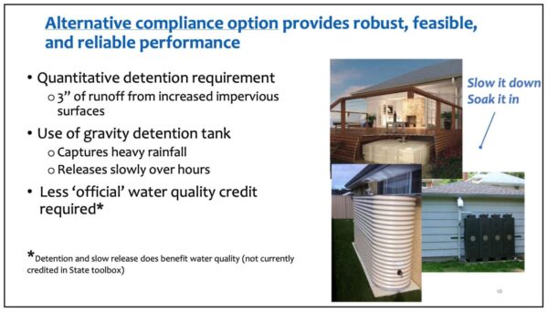
Arlington’s Department of Environmental Services will require developers to use tools such as water storage tanks to ensure new homes can retain at least 3 inches of rain, which will affect applications submitted after Sept. 13, 2021.

Currently, developers are only on the hook to improve the quality of water runoff, using rain gardens, planters, permeable driveways and tree cover.

DES staff tell ARLnow the new system will manage more water, protect downhill properties, reduce plan approval times, and give homeowners stormwater facilities that are feasible to maintain.

In a statement, staff said the change “reflects future-focused and balanced responsiveness to a diverse customer base that includes downhill neighbors, property owners, and builders.”

But some developers who work in Arlington County says the changes blindsided them and they want more input. They predict significant potential cost increases to homeowners and argue that this shifts the burden onto individuals, rather than placing responsibility with neighborhoods or the county itself.

“There is broad concern with the roll-out of this,” said Yuri Sagatov of Sagatov Homes. “There are just a lot of questions and there aren’t a lot of answers. We’re all waiting to get more information from the county to see how the changes might impact properties.”

Staff said these changes were precipitated by the increase in heavy rainfall, the growing intensity of storms, and a sense among residents that the county is not doing enough to protect properties — particularly those that are downhill from development, from the runoff caused by new homes.

A county study last summer found that the soil under new homes is 10 times less permeable than the soil under existing homes, staff said.

With the tanks, which appear to be above ground in photos, the goal is to retain rainwater during flash flooding events like that of July 8, 2019.

“Gravity detention tanks… promote a ‘slow it down and soak it in’ strategy to capture and release runoff slowly as a more robust and reliable way to handle intense rainfall,” says a DES memo.

It seems like a feasible alternative to more expensive underground systems, but the challenge will be blending them in aesthetically.

“They are talking about massive above ground cisterns,” the owner of one remodeling firm told ARLnow. “I would think neighbors would hate this. They’re going to be hideous.”

As for engaging developers during the process, county staff said enhancements to an existing program only require the county to consult with stakeholders. The county surveyed neighbors, home builders and engineers in 2019 and met with engineers early this year.

(more…)


View More Stories