Update at 11:20 p.m. — The National Weather Service confirms that an EF-0 tornado tracked through Arlington and into the District on Thursday.

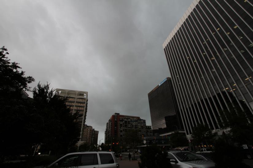
Earlier: The storms that whipped through Arlington and the D.C. region yesterday brought power outages and damage, and more trees toppled today, according to the Arlington County Fire Department.

But now the Capital Weather Gang believes the storms caused something else: a rare tornado in Arlington.

As CWG reported, the National Weather Service officially confirmed tornadoes in Herndon and in Southeast D.C. on Thursday. But the CWG team lists several other areas where they believe small tornadoes may have touched down, including in South Arlington near the Pentagon.

Radar indicated rotation there around 1:40 p.m., as noted on Twitter by weather enthusiast Ian Livingston.

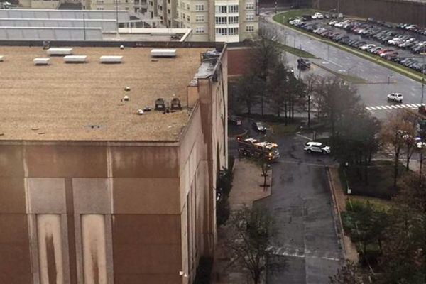
Photographic evidence of damage near the Army Navy Country Club is consistent with tornadic activity, according to CWG. That’s also close to where one person was hurt when part of the Macy’s facade and roof at the Pentagon City mall was damaged and fell onto a car yesterday.

The National Weather Service reportedly is assessing damage near the Tidal Basin to determine if a tornado occurred there and along the H Street Corridor; the same storm caused the Arlington circulation. The Capital Weather Gang indicates the possible Arlington tornado may have been a separate occurrence from the one at the Tidal Basin, or that one tornado may have passed over the entire area in question.


Puddle at Columbia Pike and S. Glebe Road (Flickr pool photo by Bekah Richards)

Big Changes Coming to DCA — The Metropolitan Washington Airports Authority has revealed updated designs of the coming changes at Reagan National Airport. Among the changes are a new commuter terminal, replacing the outdoor commuter gate 35X, and a new structure to house security checkpoints, which will be positioned before travelers enter the airport’s main terminal B/C hallway. [WTOP, WTOP]

Ethiopian Restaurant Coming to Courthouse — Chercher Ethiopian restaurant is expanding from the District to a new location at 2000 14th Street N. in Courthouse. It will be the first Virginia outpost for the acclaimed Ethiopian restaurant. Its owner says he chose Courthouse because the Rosslyn-Ballston corridor lacks Ethiopian dining options. [Washington Business Journal]

Tornado Drill Today — Yesterday was the first day of spring and today, at 9:45 a.m., Virginia is holding its annual statewide tornado drill. The drill is “a yearly opportunity to prepare Virginians for tornado emergencies and to test public warning systems.” [Virginia Dept. of Emergency Management]

Va. Pols Speaking at Arlington Dems Dinner — Democratic gubernatorial candidate Tom Perriello and state Attorney General Mark Herring will be the headline speakers at the Arlington Democrats’ annual “Blue Victory Dinner,” formerly known as the Jefferson-Jackson Dinner, on April 8. The other Democratic candidate for governor, Lt. Gov. Ralph Northam, “had a conflict and will not be able to make it.” [InsideNova]

School 5K to Close Streets — Roads will be closed in Arlington’s Williamsburg neighborhood Saturday morning for the second annual Discovery/Nottingham Friendship 5K. [Arlington County, Discovery Elementary School]

Flickr pool photo by Bekah Richards


Daffodils on the edge of a patch of woods in Fairlinton

APS Considering Elementary Options — Arlington Public Schools is considering a number of options for increasing elementary school capacity in South Arlington. Among the options are moving current Patrick Henry Elementary students to a new building while moving Drew Model School Montessori students to the current Patrick Henry building. APS is also considering the construction of a new elementary school in Pentagon City. [InsideNova, InsideNova]

Tornado Drill Today — At 9:45 a.m., Virginia will hold its annual springtime tornado drill. The Commonwealth experiences 15-20 tornados per year on average, usually between April and September. [Virginia Dept. of Emergency Management]

Local Startup Featured on MSNBC — Arlington-based moving crate startup ValueCrates was featured during a business segment on MSNBC over the weekend. [American Express]

2016 ARLnow Reader Survey — ARLnow.com is conducting our first annual reader survey. We’ve designed a survey that should take only 10 minutes to fill out, but could help ARLnow better serve the Arlington community for years to come. We would greatly appreciate your time in filling it out. [SurveyMonkey]


Update at 7:35 p.m. — Arlington is now under a Severe Thunderstorm Warning.

THE NATIONAL WEATHER SERVICE IN STERLING VIRGINIA HAS ISSUED A

* SEVERE THUNDERSTORM WARNING FOR… THE DISTRICT OF COLUMBIA… SOUTHERN MONTGOMERY COUNTY IN CENTRAL MARYLAND… NORTHERN FAIRFAX COUNTY IN NORTHERN VIRGINIA… ARLINGTON COUNTY IN NORTHERN VIRGINIA… THE CITY OF FAIRFAX IN NORTHERN VIRGINIA… THE CITY OF FALLS CHURCH IN NORTHERN VIRGINIA… SOUTHEASTERN LOUDOUN COUNTY IN NORTHERN VIRGINIA…
* UNTIL 800 PM EDT
* AT 712 PM EDT… DOPPLER RADAR INDICATED A SEVERE THUNDERSTORM CAPABLE OF PRODUCING DAMAGING WINDS IN EXCESS OF 60 MPH. THIS STORM WAS LOCATED OVER HERNDON… AND MOVING EAST AT 30 MPH.
* LOCATIONS IMPACTED INCLUDE… ARLINGTON… ROCKVILLE… GAITHERSBURG… HERNDON… FAIRFAX… VIENNA… FALLS CHURCH… RESTON… SOUTH RIDING… PIMMIT HILLS… MANTUA… DULLES INTERNATIONAL AIRPORT… GALLAUDET UNIVERSITY… NATIONALS PARK… AMERICAN LEGION BRIDGE… OLNEY… BETHESDA… HOWARD UNIVERSITY… MCLEAN AND FORT TOTTEN.

PRECAUTIONARY/PREPAREDNESS ACTIONS…

A TORNADO WATCH REMAINS IN EFFECT FOR THE AREA. ALTHOUGH A TORNADO IS NOT IMMEDIATELY LIKELY… IF ONE IS SPOTTED… ACT QUICKLY AND MOVE TO A PLACE OF SAFETY IN A STURDY STRUCTURE… SUCH AS A BASEMENT OR SMALL INTERIOR ROOM.

Strong storm approaching Arlington (radar image via Weather.com)Update at 5:40 p.m. — The evening’s first storm has passed and blue skies have returned. The storm knocked out power to more than 3,000 Dominion customers in the Falls Church area and caused some damage in Arlington.

Trees were reported down on 26th Street N., near Marymount University and on 25th Street near S. Dinwiddie Street. A large branch was reported down at N. Fillmore Street and Pershing Drive.

Earlier: The National Weather Service has issued a Tornado Watch for Arlington County and much of the surrounding D.C. area.

The watch is in effect through 8:00 p.m. Forecasters say strong storms or even tornados are possible tonight.

From NWS:

A TORNADO WATCH IS IN EFFECT FOR THE WASHINGTON AND BALTIMORE METROPOLITAN AREAS UNTIL 8 PM THIS EVENING. SEVERE THREATS ARE DAMAGING WIND GUSTS…LARGE HAIL…AND ISOLATED TORNADOES. THUNDERSTORMS MAY ALSO PRODUCE HEAVY RAIN AND LOCALIZED FLOODING TONIGHT.


Storm clouds over Rosslyn 7/3/14A Tornado Watch has been issued for Arlington and the D.C. region through 10:00 tonight.

Forecasters say severe storms are likely late this afternoon and this evening and that an isolated tornado is possible.

Showers and thunderstorms are expected to reach the around the evening rush hour.

From the National Weather Service:

THUNDERSTORMS ARE LIKELY LATE THIS AFTERNOON AND EVENING. A FEW OF THE THUNDERSTORMS MAY BECOME SEVERE WITH A THREAT OF DAMAGING WIND GUSTS…LARGE HAIL AND AN ISOLATED TORNADO.


10/19/14 leaves (Flickr pool photo by Wolfkann)

Arlington Spends More on Low-Income Students — Arlington Public Schools spend about $21,000 per pupil on low-income students, compared to the $12,000 it spends on more affluent students, according to data from the Thomas B. Fordham Institute. [Greater Greater Washington]

Tornado Struck Alexandria Last Week — A weak EF-0 tornado struck part of Alexandria this past Wednesday. A Tornado Warning was issued for Arlington as the tornado tracked north. [National Weather Service]

Teachers Endorse Kanninen — The Arlington Education Association’s political action committee has endorsed Barbara Kanninen for School Board. The teachers group said “Barbara understands that all types of students need personal support and that teachers are important partners in making this happen.” Kanninen is running against Audrey Clement.

Arlington’s ‘Ten Commandments’ — A parody video showing “Arlington County Government’s Ten Commandments” has been created by someone calling themselves “Jim Taxpayer.” The video includes commandments like “With These Riches, Which Have Become Thine, Build A New Covenant, A Glorious Car of Street, Thy Chariot of Vanity.” [YouTube]

Flickr pool photo by Wolfkann


(Updated at 1:15 p.m.) The National Weather Service issued a Tornado Warning for Arlington this afternoon as a dangerous storm system rolled through the area.

The tornado warning has since been canceled, but a flood watch remains in effect through 8:00 p.m. (See below.)

Medics in Arlington responded to at least one report of a person struck by lightning during the storms.

Police reported significant flooding along Four Mile Run in the area of I-395. Flooding was also reported on S. Scott Street near the Wellington apartments, and on Route 50 near Glebe Road.

As of 1:15 p.m., 212 Dominion customers in Arlington County were said to be without power. According to a reader, the Harris Teeter at Lee Highway and N. Harrison Street was among those that had lost power.

…FLOOD WATCH REMAINS IN EFFECT UNTIL 8 PM EDT THIS EVENING…

THE FLOOD WATCH CONTINUES FOR

* PORTIONS OF MARYLAND…THE DISTRICT OF COLUMBIA AND VIRGINIA…

* UNTIL 8 PM EDT THIS EVENING

* A STRONG COLD FRONT WILL IMPACT THE REGION TODAY. A PLUME OF HEAVY RAINFALL IS MOVING SLOWLY ACROSS THE REGION FROM WEST TO EAST THROUGH THIS EVENING. RAINFALL AMOUNTS OF ONE TO THREE INCHES CAN BE EXPECTED WITH LOCALLY HIGHER AMOUNTS POSSIBLE.

* THE HEAVY RAINFALL MAY CAUSE FLOODING OF LOW LYING AREAS… ESPECIALLY IN URBAN AREAS AND LOCATIONS ESPECIALLY PRONE TO FRESHWATER FLOODING. NEVER CROSS ROADS THAT ARE FLOODED. TURN AROUND DON`T DROWN.

PRECAUTIONARY/PREPAREDNESS ACTIONS…

A FLOOD WATCH MEANS THERE IS A POTENTIAL FOR FLOODING BASED ON CURRENT FORECASTS.

YOU SHOULD MONITOR LATER FORECASTS AND BE ALERT FOR POSSIBLE FLOOD WARNINGS. THOSE LIVING IN AREAS PRONE TO FLOODING SHOULD BE PREPARED TO TAKE ACTION SHOULD FLOODING DEVELOP.


Arlington County and the D.C. region is under a tornado watch until 9:00 tonight.

Forecasters say that severe thunderstorms are likely between 4:00 and 8:00 p.m. Tornadoes are possible as part of the expected severe weather outbreak.

From the National Weather Service:

… SEVERE THUNDERSTORMS LIKELY THIS AFTERNOON AND EVENING ALONG WITH THE POTENTIAL FOR ISOLATED TORNADOES…

WITH TEMPERATURES REACHING THE MID-TO-UPPER 80S WITHIN AND SOUTH OF THE WASHINGTON DC METROPOLITAN AREA… THE REGION IS UNDER THE THREAT OF SEVERE THUNDERSTORMS THIS AFTERNOON AND EVENING. SOME OF THESE STORMS WILL LIKELY CONTAIN DAMAGING WIND… FREQUENT CLOUD- TO-GROUND LIGHTNING… AND LARGE HAIL. ADDITIONALLY… TORNADOES ARE POSSIBLE IN A FEW OF THE STRONGEST THUNDERSTORMS. THE MOST LIKELY TIME FOR SEVERE WEATHER IS BETWEEN 400 PM AND 800 PM EDT.

THE AREA MOST VULNERABLE FOR SEVERE WEATHER IS NORTH OF INTERSTATE 64 ACROSS VIRGINIA’S NORTH-CENTRAL PIEDMONT AND WEST OF INTERSTATE 95 SOUTH OF THE CITY OF BALTIMORE MARYLAND TO FREDERICKSBURG VIRGINIA. THIS INCLUDES THE GREATER WASHINGTON DC AND BALTIMORE METROPOLITAN AREAS… HAGERSTOWN MARYLAND… THE NORTHERN AND CENTRAL SHENANDOAH VALLEY… AND CHARLOTTESVILLE VIRGINIA.

RESIDENTS AND VISITORS TO THIS REGION… ALONG WITH MARINERS ON THE CHESAPEAKE BAY AND TIDAL POTOMAC RIVER… SHOULD HAVE AN INCREASED AWARENESS OF THE THREAT OF HAZARDOUS WEATHER THIS AFTERNOON AND EVENING.

IF A SEVERE WEATHER WARNING IS ISSUED… SEEK SHELTER INDOORS IMMEDIATELY… PREFERABLY IN A BASEMENT OR THE LOWEST LEVEL OF A STURDY BUILDING. IF YOU ARE IN A BOAT… SEEK SAFE HARBOR IMMEDIATELY.


Tornado (Photo courtesy NOAA via Wikipedia)The Arlington Office of Emergency Management is asking all residents and office workers in Arlington to participate in a statewide tornado safety drill tomorrow morning.

The drill will take place at 9:45 a.m. on Tuesday. Participants are asked to “go low and stay low” by going to the lowest level of the building they are in, staying away from windows and doors, and crouching down and covering their heads, according to OEM.

Those with National Oceanic and Atmospheric Administration (NOAA) weather radios will get a test alert at 9:45, notifying them that the drill has begun.

The full press release from OEM, after the jump.

Photo courtesy NOAA via Wikipedia

(more…)


Update at 12:40 p.m. — The tornado watch has been canceled.

Update at 12:30 p.m. — The cold front passed relatively quietly through Arlington, mostly producing light rain. Our tornado danger appears to be over.

The National Weather Service has issued a Tornado Watch for the Arlington County and the D.C. region through 5:00 p.m.

The watch signifies a slight chance of tornadoes from a cold front that will be moving through the area in the early afternoon. Thunderstorms and damaging winds are also possible with the front. From NWS:

THUNDERSTORMS CONTAINING DAMAGING WINDS AND ISOLATED TORNADOES ARE POSSIBLE OVER PORTIONS OF NORTHERN VIRGINIA…THE INTERSTATE 95 CORRIDOR AND POINTS EAST. RESIDENTS SHOULD MONITOR THIS SITUATION VERY CLOSELY AND ENSURE YOUR NOAA WEATHER RADIOS ARE SET TO ALERT MODE. SEVERE WEATHER WARNINGS MAY BECOME NECESSARY. HERE ARE SOME SAFETY RULES TO KEEP IN MIND WHEN SEVERE WEATHER IS EXPECTED OR IS OCCURRING.

IF A WARNING IS ISSUED…SEEK SHELTER INDOORS IMMEDIATELY. A SEVERE THUNDERSTORM IS DEFINED AS PRODUCING QUARTER SIZE OR GREATER HAIL AND WIND GUSTS OF 58 MPH OR MORE.

TORNADOES OFTEN FORM VERY RAPIDLY FROM SEVERE THUNDERSTORMS. IF YOU ARE IN A TORNADO WATCH…AND A SEVERE THUNDERSTORM WARNING IS ISSUED FOR YOUR AREA…MONITOR LOCAL CONDITIONS CLOSELY AND BE READY TO TAKE QUICK ACTION TO SAVE YOUR LIFE.

STAY TUNED TO NOAA WEATHER RADIO…COMMERCIAL RADIO OR TELEVISION FOR THE LATEST ON THIS POTENTIAL SEVERE WEATHER EVENT. ADDITIONAL WEATHER INFORMATION…CAN BE FOUND AT WEATHER.GOV/WASHINGTON OR WEATHER.GOV/BALTIMORE.


Arlington County and much of the rest of the D.C. region is under a Tornado Watch through 5:00 p.m.

Forecasters say an incoming cold front could produce strong storms and possibly tornados. From the National Weather Service:

A STRONG COLD FRONT WILL MOVE INTO THE MID-ATLANTIC STATES TODAY. SHOWERS AND ISOLATED THUNDERSTORMS COULD PRODUCE A PERIOD HEAVY RAINFALL THIS AFTERNOON WITH LOCALIZED FLOODING MAINLY IN URBAN LOCATIONS. AN ISOLATED TORNADO AND LOCALLY DAMAGING WIND GUSTS ARE POSSIBLE WITH ANY THUNDERSTORMS THAT DEVELOP.


View More Stories