The storm as of 5 p.m.

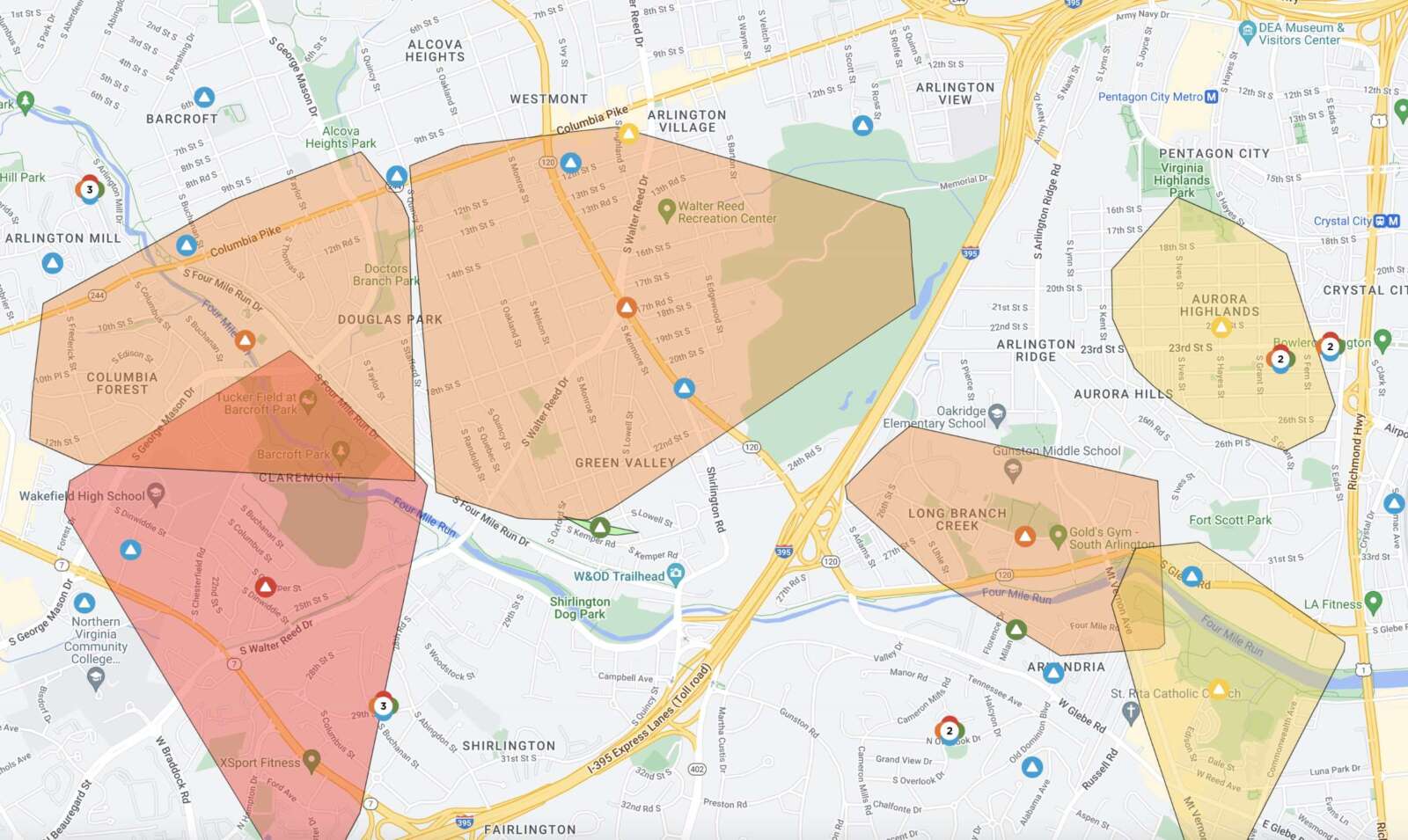
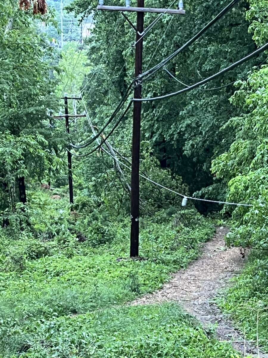
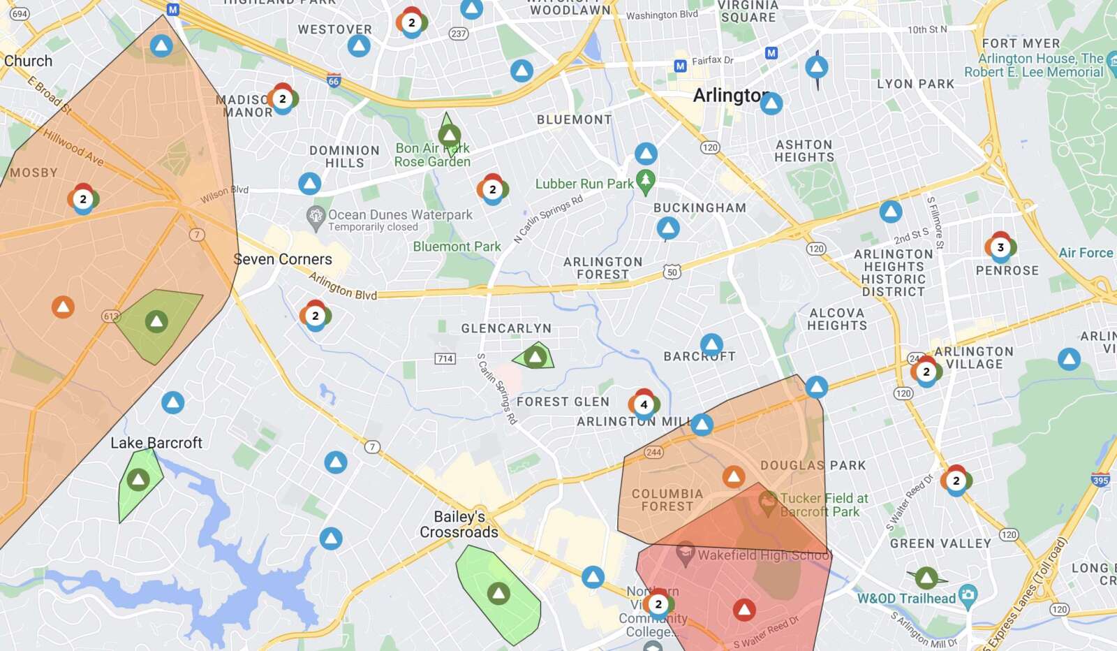
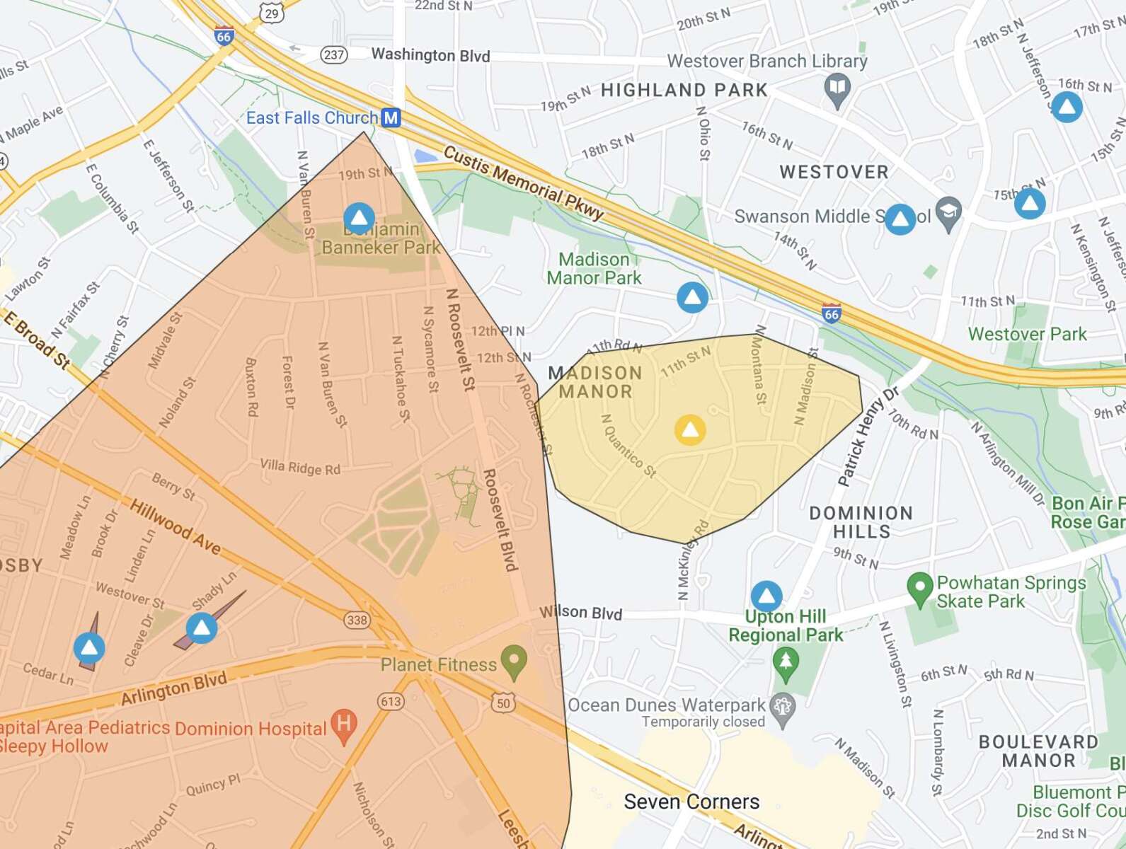
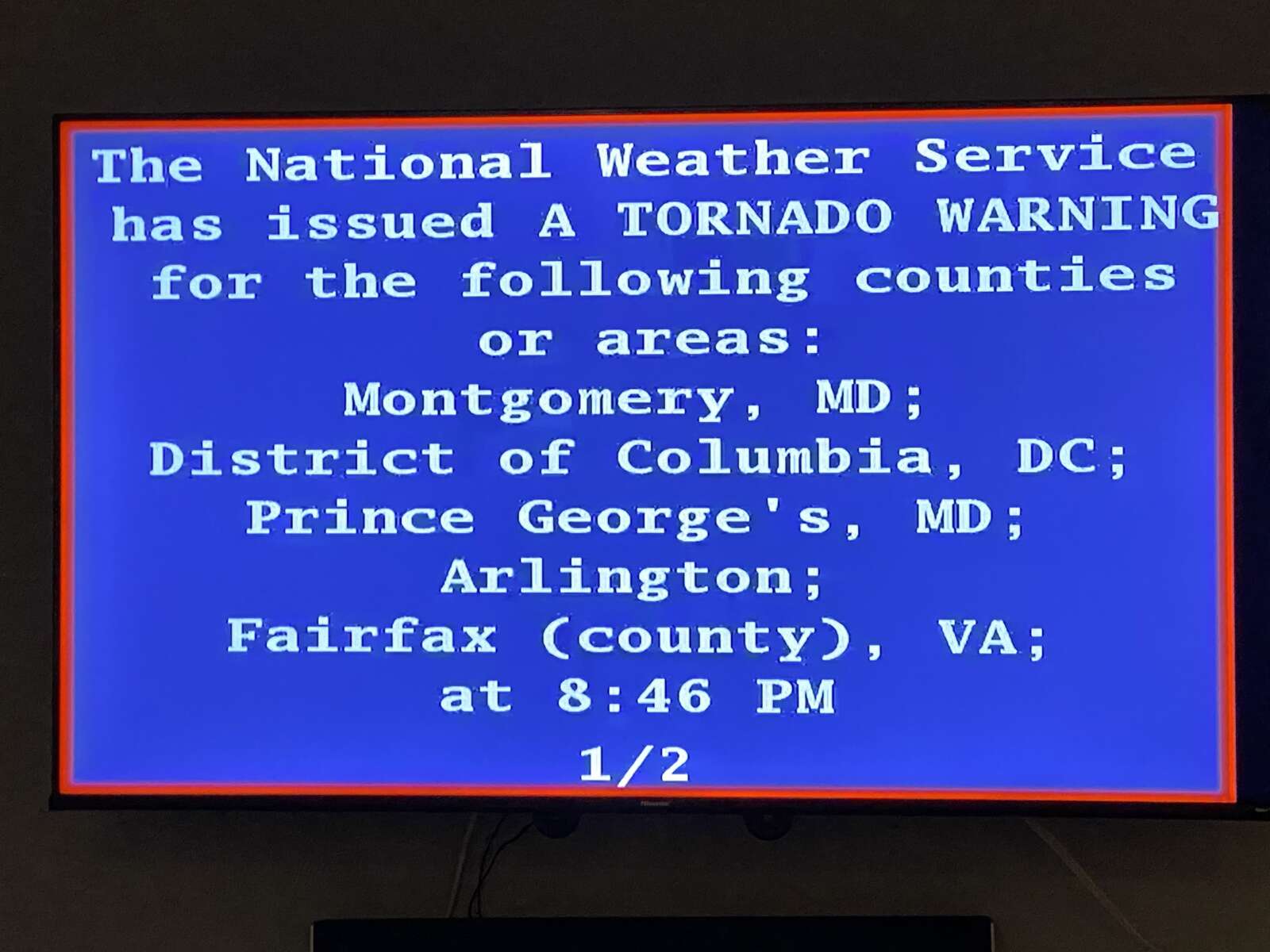
Update at 5:20 p.m. — Dominion is currently reporting 775 customers without power in Arlington, mostly in the Boulevard Manor, Arlington Forest, Douglas Park and Ashton Heights neighborhoods. It appears that Alexandria bore the brunt of the storm, with nearly 7,000 outages in the city, according to the power company. 

The National Weather Service reported a 41 mph wind gust at Reagan National Airport during the height of the storm, around 4:30 p.m.

Update at 5 p.m. — A new Flash Flood Warning has been issued for most of Arlington until 8 p.m.

From NWS:

BULLETIN – EAS ACTIVATION REQUESTED
FLASH FLOOD WARNING
NATIONAL WEATHER SERVICE BALTIMORE MD/WASHINGTON DC
457 PM EDT WED AUG 10 2022

THE NATIONAL WEATHER SERVICE IN STERLING VIRGINIA HAS ISSUED A

* FLASH FLOOD WARNING […]

* UNTIL 800 PM EDT.

* AT 457 PM EDT, DOPPLER RADAR INDICATED THUNDERSTORMS PRODUCING HEAVY RAIN ACROSS THE WARNED AREA. BETWEEN 1.5 AND 2.5 INCHES OF RAIN HAVE FALLEN. ADDITIONAL RAINFALL AMOUNTS OF 0.5 TO 1.5 INCHES ARE POSSIBLE IN THE WARNED AREA. FLASH FLOODING IS ONGOING OR EXPECTED TO BEGIN SHORTLY.

HAZARD…FLASH FLOODING CAUSED BY THUNDERSTORMS.

SOURCE…RADAR.

IMPACT…FLASH FLOODING OF SMALL CREEKS AND STREAMS, URBAN AREAS, HIGHWAYS, STREETS AND UNDERPASSES AS WELL AS OTHER POOR DRAINAGE AND LOW-LYING AREAS.

* SOME LOCATIONS THAT WILL EXPERIENCE FLASH FLOODING INCLUDE… ARLINGTON… ALEXANDRIA… BETHESDA… COLLEGE PARK… LANGLEY PARK… FALLS CHURCH… CORAL HILLS… BLADENSBURG… HOWARD UNIVERSITY… FORT TOTTEN… GALLAUDET UNIVERSITY… ROSSLYN… NATIONALS PARK… CRYSTAL CITY… RFK STADIUM… REAGAN NATIONAL AIRPORT… UNIVERSITY OF MARYLAND… LANDOVER… HYATTSVILLE… TAKOMA PARK…

PRECAUTIONARY/PREPAREDNESS ACTIONS…

TURN AROUND, DON’T DROWN WHEN ENCOUNTERING FLOODED ROADS. MOST FLOOD DEATHS OCCUR IN VEHICLES.

BASEMENT FLOODING CAN OCCUR QUICKLY AND CREATE A LIFE-THREATENING SITUATION. IF YOU ARE IN A BASEMENT, OR A RESIDENCE BELOW STREET LEVEL, MOVE TO A HIGHER FLOOR IMMEDIATELY.

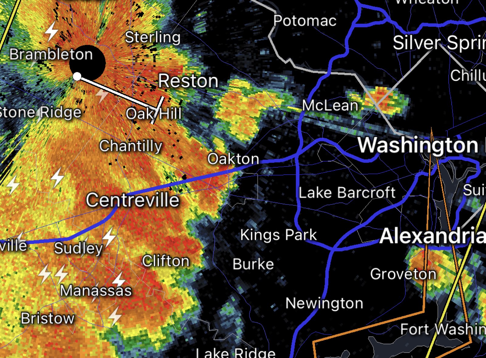
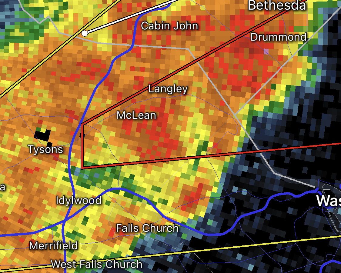
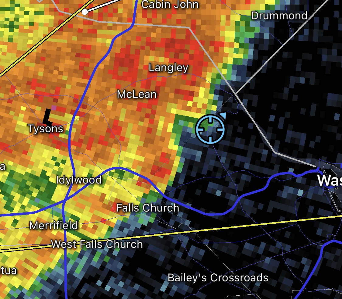
Earlier: Much of Arlington is currently under a Severe Thunderstorm Warning.

Two separate storm warnings have been issued for northern and southern portions of the county, plus a Flash Flood Warning for Alexandria and southern portions of Arlington.

One passenger on a departing flight that’s holding on the tarmac at Reagan National Airport said the storm there is causing the plane to shake. The airport is currently under a ground stop and experiencing 30-45 minute flight delays, according to the FAA.

More from the National Weather Service:

BULLETIN – IMMEDIATE BROADCAST REQUESTED
Severe Thunderstorm Warning
National Weather Service Baltimore MD/Washington DC
428 PM EDT Wed Aug 10 2022

The National Weather Service in Sterling Virginia has issued a

* Severe Thunderstorm Warning for… The northwestern District of Columbia… Southeastern Montgomery County in central Maryland… Northwestern Arlington County in northern Virginia… Northeastern Fairfax County in northern Virginia…

* Until 515 PM EDT.

* At 428 PM EDT, a severe thunderstorm was located over North Bethesda, or over Rockville, and is nearly stationary.

HAZARD…60 mph wind gusts.

SOURCE…Radar indicated.

IMPACT…Damaging winds will cause some trees and large branches to fall. This could injure those outdoors, as well as damage homes and vehicles. Roadways may become blocked by downed trees. Localized power outages are possible. Unsecured light objects may become projectiles.

* Locations impacted include… Arlington, Rockville, Bethesda, Olney, Pimmit Hills, Mclean, Howard University, American Legion Bridge, Fort Totten, Aspen Hill, Potomac, North Bethesda, North Potomac, Fairland, Tysons Corner, White Oak, Redland, Takoma Park, Great Falls and Colesville.

PRECAUTIONARY/PREPAREDNESS ACTIONS…

For your protection move to an interior room on the lowest floor of a building.


Storms approaching Arlington from the west

Update at 10:20 p.m. — Portions of northern Arlington County are now under a Flash Flood Warning after an extended period of heavy rain.

From the National Weather Service:

BULLETIN – EAS ACTIVATION REQUESTED
Flash Flood Warning
National Weather Service Baltimore MD/Washington DC
1016 PM EDT Thu Aug 4 2022

The National Weather Service in Sterling Virginia has issued a

* Flash Flood Warning for… District of Columbia… South Central Montgomery County in central Maryland… West Central Prince Georges County in central Maryland… Northern Arlington County in northern Virginia…

* Until 115 AM EDT.

* At 1016 PM EDT, Doppler radar indicated thunderstorms producing heavy rain across the warned area. Between 1 and 2 inches of rain have fallen. Additional rainfall amounts of 0.5 to 1.5 inches are possible in the warned area. Flash flooding is ongoing or expected to begin shortly.

HAZARD…Flash flooding caused by thunderstorms.

SOURCE…Radar.

IMPACT…Flash flooding of small creeks and streams, urban areas, highways, streets and underpasses as well as other poor drainage and low-lying areas.

* Some locations that will experience flash flooding include… Arlington… Bethesda… Falls Church… Howard University… Fort Totten… Rosslyn… Gallaudet University… RFK Stadium… Hyattsville… Takoma Park… Chevy Chase… Martin`s Additions…
Adams Morgan… Georgetown… American University… US Capitol… Friendship Village… Kenilworth… Silver Spring… Chillum…

PRECAUTIONARY/PREPAREDNESS ACTIONS…

Turn around, don’t drown when encountering flooded roads. Most flood deaths occur in vehicles.

Earlier: A Severe Thunderstorm Warning was just issued for Arlington.

A storm approaching the area from the west is packing strong winds and torrential rain, forecaster say.

More from the National Weather Service:

BULLETIN – IMMEDIATE BROADCAST REQUESTED
Severe Thunderstorm Warning
National Weather Service Baltimore MD/Washington DC
628 PM EDT Thu Aug 4 2022

The National Weather Service in Sterling Virginia has issued a

* Severe Thunderstorm Warning…

* Until 715 PM EDT.

* At 627 PM EDT, a severe thunderstorm was located over Annandale, moving east at 10 mph.

HAZARD…60 mph wind gusts and quarter size hail.

SOURCE…Radar indicated.

IMPACT…Damaging winds will cause some trees and large branches to fall. This could injure those outdoors, as well as damage homes and vehicles. Roadways may become blocked by downed trees. Localized power outages are possible. Unsecured light objects may become projectiles.

* Locations impacted include… Arlington, Alexandria, Bethesda, Bowie, Annandale, Clinton, Springfield, College Park, Fort Washington, Greenbelt, Fairfax, Langley Park, Beltsville, Fort Hunt, Vienna, Groveton, Forestville, Falls Church, Huntington and Largo.


Storm approaching Arlington from the west on 7/12/22

A Severe Thunderstorm Warning was just issued for Arlington County.

A strong storm is approaching the area from the west. The line of storms has already prompted a severe warning in Fairfax County.

The line of storms recently produced a 61 mile per hour wind gust at Dulles International Airport, according to the National Weather Service.

Arlington also remains under a Flood Watch tonight.

More from NWS:

BULLETIN – IMMEDIATE BROADCAST REQUESTED
SEVERE THUNDERSTORM WARNING
NATIONAL WEATHER SERVICE BALTIMORE MD/WASHINGTON DC
538 PM EDT TUE JUL 12 2022

THE NATIONAL WEATHER SERVICE IN STERLING VIRGINIA HAS ISSUED A

* SEVERE THUNDERSTORM WARNING…

* UNTIL 615 PM EDT.

* AT 537 PM EDT, SEVERE THUNDERSTORMS WERE LOCATED ALONG A LINE EXTENDING FROM NEAR NORTH POTOMAC TO NEAR LINTON HALL, MOVING EAST AT 30 MPH.

HAZARD…60 MPH WIND GUSTS AND QUARTER SIZE HAIL.

SOURCE…RADAR INDICATED.

IMPACT…DAMAGING WINDS WILL CAUSE SOME TREES AND LARGE BRANCHES TO FALL. THIS COULD INJURE THOSE OUTDOORS, AS WELL AS DAMAGE HOMES AND VEHICLES. ROADWAYS MAY BECOME BLOCKED BY DOWNED TREES. LOCALIZED POWER OUTAGES ARE POSSIBLE. UNSECURED LIGHT OBJECTS MAY BECOME PROJECTILES.

* LOCATIONS IMPACTED INCLUDE… ARLINGTON, ALEXANDRIA, CENTREVILLE, DALE CITY, ROCKVILLE, BETHESDA, RESTON, ANNANDALE, SPRINGFIELD, COLLEGE PARK, FORT WASHINGTON, GREENBELT, FAIRFAX, LANGLEY PARK, BELTSVILLE, FORT HUNT, VIENNA, GROVETON, FALLS CHURCH AND HUNTINGTON.

PRECAUTIONARY/PREPAREDNESS ACTIONS…

FOR YOUR PROTECTION MOVE TO AN INTERIOR ROOM ON THE LOWEST FLOOR OF A BUILDING.

LARGE HAIL AND DAMAGING WINDS AND CONTINUOUS CLOUD TO GROUND LIGHTNING IS OCCURRING WITH THESE STORMS. MOVE INDOORS IMMEDIATELY. LIGHTNING IS ONE OF NATURE’S LEADING KILLERS. REMEMBER, IF YOU CAN HEAR THUNDER, YOU ARE CLOSE ENOUGH TO BE STRUCK BY LIGHTNING.


Radar showing storms and heavy rain

A line of “training” thunderstorms could lead to an extended period of heavy rain and flooding in Arlington and surrounding areas.

The National Weather Service just issued a Flood Warning for the area, in effect until 3 a.m.

From NWS:

848 PM EDT Wed Jun 22 2022

…FLOOD WARNING IN EFFECT UNTIL 3 AM EDT THURSDAY…

* WHAT…Flooding caused by excessive rainfall is expected.

* WHERE…Portions of DC, central Maryland and northern Virginia, including the following counties: in DC, District of Columbia. In central Maryland, Montgomery and Prince Georges. In northern Virginia, Arlington, City of Alexandria, City of Falls Church and Fairfax.

* WHEN…Until 300 AM EDT Thursday.

* IMPACTS…Flooding of rivers, creeks, streams, and other low-lying and flood-prone locations is imminent or occurring.

* ADDITIONAL DETAILS…
– At 848 PM EDT, Doppler radar indicated heavy rain due to thunderstorms. Flooding is ongoing or expected to begin shortly in the warned area. Between 0.5 and 1 inch of rain has fallen.
– Additional rainfall amounts of 0.5 to 1.5 inches are possible in the warned area.
– Some locations that will experience flooding include… Arlington… Alexandria… Bethesda… Annandale… College Park… Langley Park… Falls Church… Huntington… National Harbor… Rosslyn… Howard University… Fort Totten… Gallaudet University… Crystal City… Nationals Park… Reagan National Airport… RFK Stadium… Potomac… North Bethesda… Fairland…
– http://www.weather.gov/safety/flood

PRECAUTIONARY/PREPAREDNESS ACTIONS…

Turn around, don`t drown when encountering flooded roads. Most flood deaths occur in vehicles.

Be especially cautious at night when it is harder to recognize the dangers of flooding.


Radar as of 11:50 a.m.

Arlington is now under a Severe Thunderstorm Warning, with a line of strong storms approaching from the west.

That’s in addition to the earlier Tornado Watch and Flood Watch.

From the National Weather Service:

BULLETIN – IMMEDIATE BROADCAST REQUESTED
Severe Thunderstorm Warning
National Weather Service Baltimore MD/Washington DC
1147 AM EDT Fri May 27 2022

The National Weather Service in Sterling Virginia has issued a

* Severe Thunderstorm Warning …

* Until 1230 PM EDT.

* At 1146 AM EDT, severe thunderstorms were located along a line extending from Lansdowne to near Chantilly to near Lake Ridge, moving northeast at 40 mph.

HAZARD…60 mph wind gusts.

SOURCE…Radar indicated.

IMPACT…Damaging winds will cause some trees and large branches to fall. This could injure those outdoors, as well as damage homes and vehicles. Roadways may become blocked by downed trees. Localized power outages are possible. Unsecured light objects may become projectiles.

* Locations impacted include… Arlington, Alexandria, Germantown, Centreville, Rockville, Bethesda, Gaithersburg, Reston, Annandale, Clinton, Olney, Springfield, College Park, South Riding, Fort Washington, Herndon, Greenbelt, Fairfax, Langley Park and Beltsville.

PRECAUTIONARY/PREPAREDNESS ACTIONS…

A Tornado Watch remains in effect until 200 PM EDT for District of Columbia…central Maryland…and northern Virginia.

For your protection move to an interior room on the lowest floor of a building.

A Tornado Watch remains in effect until 200 PM EDT for District of Columbia…central Maryland…and northern Virginia.


Update at 10 a.m. — More than 2,000 Dominion customers are still without power in Arlington.

Update at 11 p.m. — The number of Dominion customers still in the dark is down modestly, to 7,378. A company spokeswoman said “the storms left a lot damage” and “crews will work thru the night as quickly & safely as possible.” More than 20,000 customers are without power throughout Northern Virginia.

Meanwhile, a transformer explosion was recently reported in the Barcroft neighborhood, likely complicating restoration efforts.

Update at 8:40 p.m. — There are 8,295 Dominion customers without power in Arlington, according to the utility company. Outages have been reported in the East Falls Church, Madison Manor, Columbia Forest, Claremont, Douglas Park, Green Valley, Long Branch Creek and Aurora Highlands neighborhoods, among others.

Update at 7:25 p.m. — A Flood Warning has been issued as well.

718 PM EDT Sun May 22 2022

…FLOOD WARNING IN EFFECT UNTIL 115 AM EDT MONDAY…

* WHAT…Flooding caused by excessive rainfall is expected.

* WHERE…Portions of DC, central Maryland and northern Virginia, including the following counties: District of Columbia. In central Maryland, Montgomery and Prince Georges. In northern Virginia, Arlington, City of Alexandria, City of Fairfax, City of Falls Church, and Fairfax.

* WHEN…Until 115 AM EDT.

* IMPACTS…Flooding of rivers, creeks, streams, and other low-lying and flood-prone locations is imminent or occurring.

* ADDITIONAL DETAILS…

– At 716 PM EDT, Doppler radar indicated heavy rain due to thunderstorms. Flooding is expected to begin shortly in the warned area. Between 0.5 and 1 inch of rain has fallen.
– Additional rainfall amounts of 0.5 to 1.5 inches are possible in the warned area.
– Some locations that will experience flooding include… Arlington… Alexandria… Bethesda… Reston… Annandale… Springfield… College Park… Fairfax… Langley Park… Beltsville… Vienna… Falls Church… Huntington… Coral Hills… Bladensburg… Mantua… Pimmit Hills… Mclean… Rosslyn… American Legion Bridge…

PRECAUTIONARY/PREPAREDNESS ACTIONS…

Turn around, don’t drown when encountering flooded roads. Most flood deaths occur in vehicles.

Update at 7:10 p.m. — Get ready for round two. Arlington is under another Severe Thunderstorm Warning, this time until 8 p.m.

From the National Weather Service:

BULLETIN – IMMEDIATE BROADCAST REQUESTED
Severe Thunderstorm Warning
National Weather Service Baltimore MD/Washington DC
704 PM EDT Sun May 22 2022

The National Weather Service in Sterling Virginia has issued a

* Severe Thunderstorm Warning…

* Until 800 PM EDT.

* At 703 PM EDT, severe thunderstorms were located along a line extending from near Damascus to 13 miles north of Mineral, moving east at 30 mph.

HAZARD…60 mph wind gusts.

SOURCE…Measured gust to 58 mph at Dulles Airport.

IMPACT…Damaging winds will cause some trees and large branches to fall. This could injure those outdoors, as well as damage homes and vehicles. Roadways may become blocked by downed trees. Localized power outages are possible. Unsecured light objects may become projectiles.

* Locations impacted include… Arlington, Alexandria, Stafford, Columbia, Germantown, Centreville, Dale City, Rockville, Bethesda, Gaithersburg, Reston, Leesburg, Annandale, Olney, Springfield, College Park, Fredericksburg, South Riding, Fort Washington and Herndon.

PRECAUTIONARY/PREPAREDNESS ACTIONS…

For your protection move to an interior room on the lowest floor of a building.

The earlier storm packed hail, strong winds and flooding downpours in parts of Arlington.

(more…)


Storms bring heavy rain, wind and flooding (file photo)

Update at 7:55 a.m. — The Flood Warning is now in effect until 4 p.m. as the rain continues throughout most of the day.

Earlier: Flooding is expected to take place in parts of Arlington overnight due to an extended period of heavy rain and storms.

The National Weather Service issued a Flood Warning for Arlington County and surrounding areas just before midnight.

From NWS:

1148 PM EDT Fri May 6 2022

…FLOOD WARNING IN EFFECT UNTIL 745 AM EDT SATURDAY…

* WHAT…Flooding caused by excessive rainfall is expected.

* WHERE…Washington DC, central Maryland and northern Virginia, including the following counties: in DC, District of Columbia. In central Maryland, Montgomery and Prince Georges. In northern Virginia, Arlington, City of Alexandria, City of Fairfax, City of Falls Church, City of Manassas, City of Manassas Park, Fairfax, Loudoun and Prince William.

* WHEN…Until 745 AM EDT Saturday.

* IMPACTS…Flooding of creeks, streams, urban areas, and other low-lying and flood-prone locations is imminent or occurring.

* ADDITIONAL DETAILS…

– At 1145 PM EDT, Doppler radar indicated heavy rain due to showers and isolated thunderstorms. Flooding is ongoing or expected to begin shortly in the warned area. Between 0.5 and 1 inch of rain has fallen.

– Additional rainfall amounts of 1 to 3 inches are possible in the warned area.

PRECAUTIONARY/PREPAREDNESS ACTIONS…

Turn around, don’t drown when encountering flooded roads. Most flood deaths occur in vehicles.


Update at 9:20 p.m. — There are Metro delays after a tornado might have touched down in the Tysons area.

Update at 9 p.m. — The Tornado Warning has been cancelled, according to NBC 4’s Doug Kammerer.

Update at 8:50 p.m. — Part of North Arlington is now under a Tornado Warning.

BULLETIN – EAS ACTIVATION REQUESTED
Tornado Warning
National Weather Service Baltimore MD/Washington DC
846 PM EDT Thu Mar 31 2022

The National Weather Service in Sterling Virginia has issued a

* Tornado Warning for… The northern District of Columbia… Southeastern Montgomery County in central Maryland… Northwestern Prince Georges County in central Maryland… North central Arlington County in northern Virginia… Northeastern Fairfax County in northern Virginia…

* Until 915 PM EDT.

* At 846 PM EDT, a severe thunderstorm capable of producing a tornado was located over Mclean, moving east at 30 mph.

HAZARD…Tornado.

SOURCE…Radar indicated rotation.

IMPACT…For those in the direct path of a tornado touchdown, flying debris will be dangerous to those caught without shelter. Damage to roofs, siding, and windows may occur. Mobile homes may be damaged or destroyed. Tree damage is likely.

* This dangerous storm will be near… Arlington around 855 PM EDT. Bethesda, Martin`s Additions, American University, Friendship Village and Georgetown around 900 PM EDT. Fort Totten and Chevy Chase around 905 PM EDT. Langley Park, Takoma Park and Hillandale around 910 PM EDT. Hyattsville and Adelphi around 915 PM EDT.

Other locations impacted by this tornadic thunderstorm include Rivercrest, Little Falls, Brentwood, West Mclean, Chevy Chase Village, Catholic University, Langley, North Brentwood, Chillum and National Zoo.

PRECAUTIONARY/PREPAREDNESS ACTIONS…

TAKE COVER NOW! Move to a basement or an interior room on the lowest floor of a sturdy building. Avoid windows. If you are outdoors, in a mobile home, or in a vehicle, move to the closest substantial shelter and protect yourself from flying debris.

Earlier: Part of Arlington is now under a Severe Thunderstorm Warning.

A Tornado Warning has also been issued for parts of Fairfax County, including neighboring McLean.

More from the National Weather Service:

818 PM EDT Thu Mar 31 2022

The National Weather Service in Sterling Virginia has issued a

* Severe Thunderstorm Warning…

* Until 900 PM EDT.

* At 818 PM EDT, a severe thunderstorm was located over Centreville, moving east at 50 mph.

HAZARD…60 mph wind gusts.

SOURCE…Radar indicated.

IMPACT…Damaging winds will cause some trees and large branches to fall. This could injure those outdoors, as well as damage homes and vehicles. Roadways may become blocked by downed trees. Localized power outages are possible. Unsecured light objects may become projectiles.

* Locations impacted include… Arlington, Centreville, Bethesda, Reston, Annandale, College Park, Greenbelt, Fairfax, Langley Park, Beltsville, Vienna, Falls Church, Largo, Coral Hills, Bladensburg, Mantua, Pimmit Hills, Mclean, Fedex Field and American Legion Bridge.

PRECAUTIONARY/PREPAREDNESS ACTIONS…

For your protection move to an interior room on the lowest floor of a building.


The first freeze of the season is expected to happen tonight in Arlington.

With overnight temperatures expected to dip as low as 30 degrees, now is the time to protect sensitive plants and to turn off the valves leading to outdoor water pipes and hose bibbs, allowing them to drain.

More from the National Weather Service:

953 AM EDT Thu Nov 4 2021

…FREEZE WARNING IN EFFECT FROM 2 AM TO 9 AM EDT FRIDAY…

* WHAT…Sub-freezing temperatures as low as 30 expected.

* WHERE…In Maryland, Southern Baltimore, Prince Georges, Anne Arundel and Charles Counties. In District of Columbia, District of Columbia. In Virginia, Arlington/Falls Church/Alexandria, and King George County.

* WHEN…From 2 AM to 9 AM EDT Friday.

* IMPACTS…Frost and freeze conditions will kill crops, other sensitive vegetation and possibly damage unprotected outdoor plumbing.

PRECAUTIONARY/PREPAREDNESS ACTIONS…

Take steps now to protect tender plants from the cold. To prevent freezing and possible bursting of outdoor water pipes they should be wrapped, drained, or allowed to drip slowly. Those that have in-ground sprinkler systems should drain them and cover above-ground pipes to protect them from freezing.

The first freeze signals the end of the growing season and the end of Frost Advisories and Freeze Warnings until next season. The growing season has already ended in the outer reaches of the D.C. area.


Boundaries of the Flood Warning that includes Arlington (via NWS)

Arlington and much of the region is now under a Flood Warning as rain continues to fall.

The warning was issued by the National Weather Service just after 12:30 p.m. Arlington is also under an earlier Coastal Flood Warning for significant tidal flooding along the Potomac.

More on the latest warning from NWS:

1234 PM EDT FRI OCT 29 2021

THE NATIONAL WEATHER SERVICE IN STERLING VIRGINIA HAS ISSUED A

* FLOOD WARNING…

* UNTIL 630 PM EDT.

* AT 1234 PM EDT, DOPPLER RADAR INDICATED HEAVY RAIN WITH RAINFALL AMOUNTS AROUND 0.5 AND 1.5 INCHES ACROSS MOST OF THE WARNED AREA. A PERIOD OF HEAVY RAIN IS EXPECTED THIS AFTERNOON THROUGH 3 PM WITH RAINFALL RATES AROUND ONE INCH PER HOUR. THIS WILL CAUSE CREEKS AND STREAMS TO RISE THROUGH LATE THIS AFTERNOON. FLOODING IS EXPECTED TO BEGIN SHORTLY IN THE WARNED AREA.

* SOME LOCATIONS THAT WILL EXPERIENCE FLOODING INCLUDE… ARLINGTON… ALEXANDRIA… CENTREVILLE… DALE CITY… ROCKVILLE… BETHESDA… RESTON… ANNANDALE… CLINTON… SPRINGFIELD… COLLEGE PARK… SOUTH RIDING… FORT WASHINGTON… HERNDON… GREENBELT… FAIRFAX… LANGLEY PARK… BELTSVILLE… FORT HUNT… VIENNA…

ADDITIONAL RAINFALL AMOUNTS OF 1 TO 2.5 INCHES ARE POSSIBLE IN THE WARNED AREA.

PRECAUTIONARY/PREPAREDNESS ACTIONS…

TURN AROUND, DON’T DROWN WHEN ENCOUNTERING FLOODED ROADS. MOST FLOOD DEATHS OCCUR IN VEHICLES.

Via Twitter:

https://twitter.com/ReadyArlington/status/1454127524766752777


It’s going to be nasty, rainy Friday.

Arlington will be under both a Flood Watch and a Coastal Flood Warning tomorrow. On top of that, strong winds and the possibility of some severe thunderstorms are in the forecast.

The Flood Watch takes effect Friday morning. From the National Weather Service:

849 PM EDT Thu Oct 28 2021

…FLOOD WATCH REMAINS IN EFFECT FROM FRIDAY MORNING THROUGH FRIDAY AFTERNOON…

The Flood Watch continues for

* Portions of DC, Maryland and northern Virginia, including the following areas: in DC, District of Columbia. In Maryland, Anne Arundel, Central and Southeast Howard, Central and Southeast Montgomery, Prince Georges and Southern Baltimore. In northern Virginia, Arlington/Falls Church/Alexandria, Fairfax and Prince William/Manassas/Manassas Park.

* From Friday morning through Friday afternoon.

* Rainfall amounts around 1 to 2 inches are most likely with isolated amounts of 2 to 4 inches possible.

* Heavy amounts of rain will cause creeks and streams to slowly rise, possibly out of their banks as well as the potential for flooding in urban areas.

PRECAUTIONARY/PREPAREDNESS ACTIONS…

You should monitor later forecasts and be alert for possible Flood Warnings. Those living in areas prone to flooding should be prepared to take action should flooding develop.

While Arlington’s river shoreline is not developed, unlike our neighbors in Alexandria, significant coastal flooding may inundate trails along the Potomac. A rare Coastal Flood Warning is currently in effect.

…COASTAL FLOOD WARNING NOW IN EFFECT UNTIL 2 PM EDT SATURDAY…

* WHAT…Two to three feet of inundation above ground level expected in low lying areas due to tidal flooding.

* WHERE…Shoreline in the District of Columbia, Arlington County, and the City of Alexandria.

* WHEN…Until 2 PM EDT Saturday, especially around the time of high tide.

* IMPACTS…The unprotected area on the Southwest Waterfront at the DC Seafood Market is expected to flood. Water is expected
to approach parts of the Hains Point Loop Road, but it will likely be closed. Water is expected to approach buildings near King Street and Union Street. Shoreline inundation up to one foot above ground is possible elsewhere.

* ADDITIONAL DETAILS…Tides up to 4 feet above normal. The next high tide at Washington Channel is at 2:18 AM and 3:14 PM. The next high tide at Alexandria is at 2:36 AM and 3:32 PM.

PRECAUTIONARY/PREPAREDNESS ACTIONS…

Take the necessary actions to protect flood-prone property. If travel is required, do not drive around barricades or through water of unknown depth.

NWS is calling for wind gusts up to 37 mph tomorrow, raising the possibility of falling trees and branches, as well as power outages.

More via Twitter:

https://twitter.com/ReadyArlington/status/1453742757718200331


View More Stories