Storm clouds, as seen from Rosslyn (staff photo by Jay Westcott)

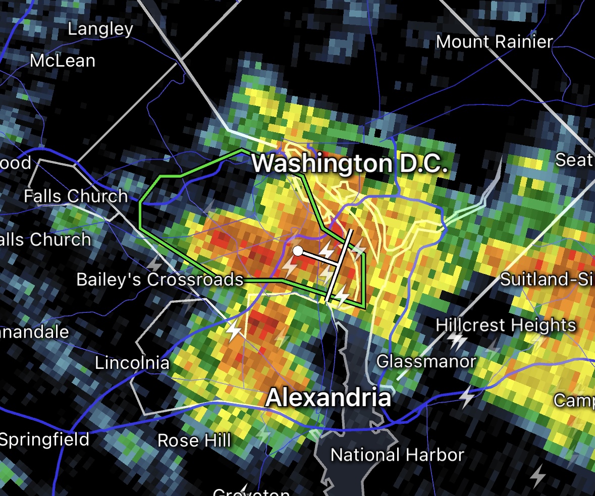
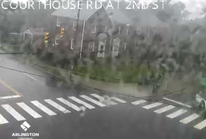
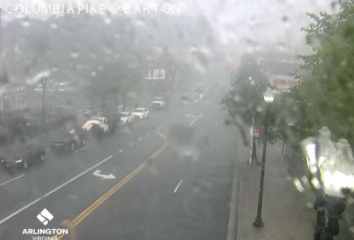
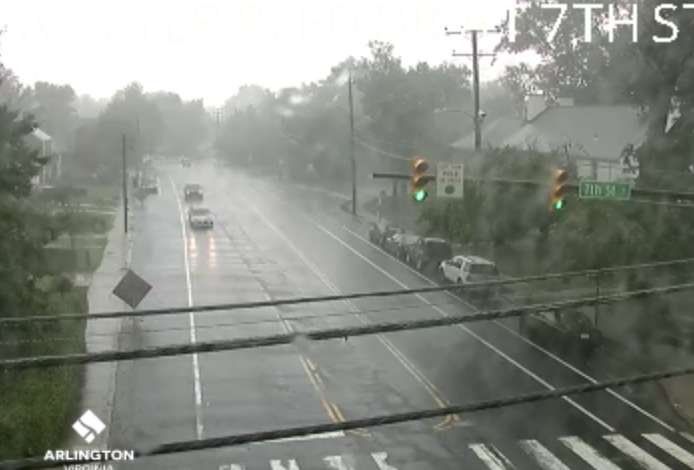
A Flood Watch has been issued for Arlington, as heavy rain and strong storms are possible starting late this afternoon.

The Flood Watch will take effect at 5 p.m. and run through early Tuesday morning. An “anomalous” amount of moisture in the atmosphere may lead to deluges that could cause flooding, forecasters say.

Meanwhile, severe storms and even an isolated tornado are possible tonight in Arlington and the D.C. area., the National Weather Service says.

More on the Flood Watch, below, from NWS.

155 PM EDT Mon Aug 14 2023

…FLOOD WATCH IN EFFECT FROM 5 PM EDT THIS AFTERNOON THROUGH LATE TONIGHT…

* WHAT…Flooding caused by excessive rainfall is possible.

* WHERE…Portions of DC, Maryland and northern Virginia, including the following areas: in DC, District of Columbia. In Maryland, Anne Arundel, Cecil, Central and Southeast Howard, Central and Southeast Montgomery, Northern Baltimore, Northwest Harford, Northwest Howard, Northwest Montgomery, Prince Georges, Southeast Harford and Southern Baltimore. In northern Virginia, Arlington/Falls Church/Alexandria, Eastern Loudoun and Fairfax.

* WHEN…From 5 PM EDT this afternoon through late tonight.

* IMPACTS…Excessive runoff may result in flooding of rivers, creeks, streams, and other low-lying and flood-prone locations.

* ADDITIONAL DETAILS…
– Anomalous moisture will overspread the region ahead of a cold front that will pass through tonight. Multiple rounds of showers and thunderstorms are possible this evening into the overnight. Rain rates over two inches per hour are possible. Urban areas and flood prone roadways will be of a particular concern.
– Please visit weather.gov/safety/flood for flood safety and preparedness information

PRECAUTIONARY/PREPAREDNESS ACTIONS…

You should monitor later forecasts and be alert for possible Flood Warnings. Those living in areas prone to flooding should be prepared to take action should flooding develop.


An ominous storm cloud over Arlington in July 2023 (Flickr pool photo by John Sonderman)

(Updated at 3 p.m.) A widespread outbreak of severe weather is expected this evening, prompting a Tornado Watch for Arlington and much of the region.

Forecasters say the threats include “damaging and locally destructive hurricane-force winds, along with the potential for large hail and tornadoes, even strong tornadoes.”

Winds in excess of 70 miles per hour are possible.

Wind threat on Aug. 7, 2023 (via National Weather Service)

The Tornado Watch is in effect until 9 p.m.

Arlington Public Schools, meanwhile, is closing facilities early today due to the weather threat. From a School Talk email to families:

Due to forecasted severe weather, Arlington Public Schools will shift to virtual operations today, Aug. 7, at 4 p.m. All APS facilities and programs held after 4 p.m. are canceled unless otherwise stated.

Extracurricular [activities], games, team practices, field trips, adult education classes and programs in schools and on school grounds are canceled this evening. For your safety, we strongly urge the community to stay off the roads between the hours of 4 and 8 p.m.

Federal government and Arlington National Cemetery are also closing early today, at 3 p.m., while Arlington County government offices are closing at 4 p.m.

The expected outbreak follows the storms just over a week ago that toppled trees throughout Arlington and knocked out power to more than 34,000 Dominion customers.

More from the National Weather Service:

…SEVERE WEATHER OUTBREAK EXPECTED OVER THE MID-ATLANTIC REGION BETWEEN 2 PM AND 10 PM TODAY, INCLUDING THE GREATER BALTIMORE/WASHINGTON METROPOLITAN AREAS…

An outbreak of severe storms is expected this afternoon and evening across the greater Baltimore/Washington region, with numerous severe thunderstorms expected. There is a significant threat for damaging and locally destructive hurricane-force winds, along with the potential for large hail and tornadoes, even strong tornadoes.

The timing of this outbreak varies with your location. West of the Blue Ridge Mountains, you can expect the storms to arrive between 12 Noon and 3 PM. East of the Blue Ridge Mountains, timing will be from 4 PM to 8 PM. The greater Baltimore/Washington Metropolitan Areas can expect the storms to arrive between 5 PM and 7 PM.

Now is the time to review your severe weather safety procedures for the possibility of dangerous weather today. Do not be outdoors when the storms arrive. When you hear thunder, go indoors to a sturdy building or structure. While seeking shelter indoors, go to the lowest floor to an interior room. Stay away from windows. Those in mobile homes or weaker structures should plan ahead of time to shelter in a stronger shelter. Be prepared for extended power outages, and the potential for some roads to be blocked by fallen trees.

For the after-event cleanup, do not go outside until 30 minutes after you hear the last thunder, otherwise you will be still susceptible to lightning strikes. Be aware of downed power lines and unstable branches and trees.

Stay tuned to NOAA Weather Radio, weather.gov, or other media for watches and warnings. If a Severe Thunderstorm Warning or Tornado Warning is issued for your area, move to a place of safety, ideally in an interior room on the lowest level of a sturdy building.

Much of the D.C. area, including Arlington, is under a 4 out of 5 risk of severe weather, a rare designation not seen in the region in more than a decade.

(more…)


Thunderstorms and heavy rain in Westover in 2021 (staff photo by Jay Westcott)

Get ready for some wild weather over the next day and a half.

First up are some storms tonight (Sunday) that are likely to be packing torrential rainfall. The heavy rain could cause flash flooding, prompting a Flood Watch to be issued this afternoon, taking effect at 8 p.m.

More from the National Weather Service:

239 PM EDT Sun Aug 6 2023

…FLOOD WATCH IN EFFECT FROM 8 PM THIS EVENING TO 2 AM EDT MONDAY…

* WHAT…Flash flooding caused by excessive rainfall is possible.

* WHERE…Portions of DC, Maryland and northern Virginia, including the following areas: in DC, District of Columbia. In Maryland, Anne Arundel, Central and Southeast Howard, Central and Southeast Montgomery, Prince Georges, Southeast Harford and Southern Baltimore. In northern Virginia, Arlington/Falls Church/Alexandria, Central and Southeast Prince William/Manassas/Manassas Park, Fairfax and Stafford.

* WHEN…From 8 PM this evening to 2 AM EDT Monday.

* IMPACTS…Excessive runoff may result in flooding of rivers, creeks, streams, and other low-lying and flood-prone locations.

* ADDITIONAL DETAILS…
– Heavy rainfall moving through with the potential for 1 to 2 inches of rainfall, locally higher, in a short period of time.
– Please visit www.weather.gov/safety/flood for flood safety and preparedness information

Monday has the potential for even more active weather.

Arlington, D.C. and other parts of the region are under an “enhanced” risk of severe weather, according to a National Weather Service outlook. Severe winds are likely, according to NWS forecasters, noting the “seriousness” of the threat.

Meanwhile, large hail and even a tornado are also possible in the D.C. area.

Severe wind outlook for Aug. 7, 2023 (via National Weather Service)

According to NWS, this is the first time that D.C. has ever had a 45% or greater risk of severe winds on its next-day outlook.

The last instance of such a high probability of severe winds was the same-day outlook on Halloween day 2019.


Storms approaching at 4:30 p.m.

(Update at 4:40 p.m.) All of Arlington is now under a Severe Thunderstorm Warning.

More such warnings are likely as a line of strong storms approach from the west. Forecasters say the storms are packing very high winds, likely to cause damage and power outages.

More from the National Weather Service:

BULLETIN – IMMEDIATE BROADCAST REQUESTED
Severe Thunderstorm Warning
National Weather Service Baltimore MD/Washington DC
409 PM EDT Sat Jul 29 2023

The National Weather Service in Sterling Virginia has issued a

* Severe Thunderstorm Warning…

* Until 430 PM EDT.

* At 409 PM EDT, a severe thunderstorm was located over Herndon, moving east at 30 mph.

HAZARD…60 mph wind gusts and quarter size hail.

SOURCE…Radar indicated.

IMPACT…Damaging winds will cause some trees and large branches to fall. This could injure those outdoors, as well as damage homes and vehicles. Roadways may become blocked by downed trees. Localized power outages are possible. Unsecured light objects may become projectiles.

* Locations impacted include… Arlington, Bethesda, Reston, South Riding, Herndon, Vienna, Falls Church, Broadlands, Lowes Island, Brambleton, Pimmit Hills, Mclean, American Legion Bridge, Dulles International Airport, Potomac, Ashburn, Oakton, Sterling, Chantilly and Tysons Corner.

PRECAUTIONARY/PREPAREDNESS ACTIONS…

For your protection move to an interior room on the lowest floor of a building.

Earlier: Arlington County is again under a Severe Thunderstorm Watch.

The National Weather Service issued the watch for Arlington, D.C. and surrounding areas. It’s in effect Saturday afternoon through 9 p.m.

Hail, damaging wind gusts and frequent lightning are all possible, while “an isolated tornado cannot be ruled out,” according to NWS.

The watch follows a series of storms Friday evening, though none caused significant damage in Arlington.


Storm clouds over Ballston (staff photo by Jay Westcott)

Thursday’s heat will help to fuel strong storms tonight, forecasters say.

A Severe Thunderstorm Watch was just issued for Arlington, the District, and other surrounding areas. It’s in effect until 11 p.m.

More from the National Weather Service:

A Heat Advisory is in effect for the entire outlook area from until 8 PM today.

A Severe Thunderstorm Watch is in effect until 11 PM for the Washington and Baltimore Metropolitan areas. Elsewhere, scattered storms will be capable of producing damaging winds and large hail through this evening.


Storm clouds over Rosslyn (staff photo by Jay Westcott)

(Updated at 12:50 p.m.) Arlington, D.C. and other parts of the region are now under both a Severe Thunderstorm Watch and a Flood Watch

The D.C. area is on the southern end of the Severe Thunderstorm Watch area, which runs up the East Coast and includes Philadelphia, New York City, and much of Connecticut. That watch is in effect until 8 p.m.

Strong storms packing frequent lightning, damaging hail and wind gusts up to 70 mph are possible, according to the National Weather Service. Storms are expected later this afternoon and into the evening.

Following the storm watch, NWS issued a Flood Watch for the region as well.

…FLOOD WATCH IN EFFECT UNTIL 8 PM EDT THIS EVENING…

* WHAT…Flash flooding caused by excessive rainfall is possible.

* WHERE…Portions of DC, Maryland and northern Virginia, including the following areas: in DC, District of Columbia. In Maryland, Anne Arundel, Calvert, Cecil, Central and Southeast Howard, Central and Southeast Montgomery, Charles, Prince Georges, Southeast Harford and Southern Baltimore. In northern Virginia, Arlington/Falls Church/Alexandria, Central and Southeast Prince William/Manassas/Manassas Park and Fairfax.

* WHEN…Until 8 PM EDT this evening.

* IMPACTS…Excessive runoff may result in flooding of rivers, creeks, streams, and other low-lying and flood-prone locations.

* ADDITIONAL DETAILS…
– Multiple rounds of thunderstorms are possible this afternoon into this evening. Where multiple thunderstorms occur, rainfall totals on the order of one to three inches are possible in a short period of time.
– Please visit www.weather.gov/safety/flood for flood safety and preparedness information

More from NWS, via Twitter:


Storms bring heavy rain, wind and flooding at night (file photo)

The possibility of a succession of storms tonight packing heavy rain has prompted a Flood Watch from the National Weather Service.

The watch is in effect until 4 a.m. for Arlington, the District and much of the Washington region. Forecasters say flash flooding may occur during prolonged downpours.

More from NWS:

…FLOOD WATCH IN EFFECT UNTIL 4 AM EDT SUNDAY…

* WHAT…Flash flooding caused by excessive rainfall is possible. […]

* WHEN…Until 4 AM EDT Sunday.

* IMPACTS…Excessive runoff may result in flooding of rivers, creeks, streams, and other low-lying and flood-prone locations. Flooding may occur in poor drainage and urban areas.

* ADDITIONAL DETAILS…
– A seasonably moist airmass with ample moisture content ahead of an approaching frontal boundary will result in numerous showers and thunderstorms. These showers and thunderstorms will be capable of producing heavy rainfall with totals on the order of 1 to 3 inches with locally higher amounts where thunderstorms may train. These totals may result in flash flooding, particularly in urban areas and those that have observed recent heavy rainfall.


Storm clouds moving over Ballston (staff photo by Jay Westcott)

Update at 1:20 p.m. on 7/9/23 — Arlington County and surrounding areas are now under a Severe Thunderstorm Watch in addition to the Flood Watch. Damaging wind and hail are possible from the storms, forecasters say.

Earlier: More slow-moving downpours are expected later in the day on Sunday, prompting a Flood Watch.

The new alert from the National Weather Service comes a day after one such storm drenched much of Arlington County, leading to a Flash Flood Warning as well as water rescues near Pentagon City.

The Flood Watch is in effect from noon to 10 p.m. Sunday for Arlington, D.C. and much of the region.

More from NWS:

…FLOOD WATCH IN EFFECT FROM SUNDAY AFTERNOON THROUGH SUNDAY EVENING…

* WHAT…Flash flooding caused by excessive rainfall is possible.

* WHERE…Portions of DC, Maryland and northern Virginia, including the following areas: in DC, District of Columbia. In Maryland, Anne Arundel, Calvert, Carroll, Cecil, Central and Southeast Howard, Central and Southeast Montgomery, Charles, Frederick MD, Northern Baltimore, Northwest Harford, Northwest Howard, Northwest Montgomery, Prince Georges, Southeast Harford, Southern Baltimore and St. Marys. In northern Virginia, Arlington/Falls Church/Alexandria, Central and Southeast Prince William/Manassas/Manassas Park, Eastern Loudoun, Fairfax, Northern Fauquier, Northwest Prince William, Southern Fauquier, Stafford and Western Loudoun.

* WHEN…From Sunday afternoon through Sunday evening.

* IMPACTS…Excessive runoff may result in flooding of rivers, creeks, streams, and other low-lying and flood-prone locations. Flooding may occur in poor drainage and urban areas.

* ADDITIONAL DETAILS…

– Slow moving thunderstorms capable of producing very heavy rainfall are expected across the watch area Sunday afternoon into Sunday evening. A widespread 1 to 2 inches of rainfall is expected across the watch area, with isolated totals in excess of 4 inches possible. This heavy rainfall may lead to rapid rises of water on creeks, streams, urban and poor drainage areas, and in other flood-prone locations.

– Please visit www.weather.gov/safety/flood for flood safety and preparedness information


Update at 1:35 p.m. — A water rescue is underway in the Pentagon City area after high water stranded multiple people in vehicles.

Update at 1 p.m. — A Flash Flood Warning has been issued for a large portion of Arlington. A near-stationary storm is inundating south and central parts of the county, causing flooding.

From the National Weather Service:

The National Weather Service in Sterling Virginia has issued a

* Flash Flood Warning for… Southeastern Arlington County in northern Virginia…

* Until 400 PM EDT.

* At 1254 PM EDT, Doppler radar indicated thunderstorms producing heavy rain across the warned area. Between 1 and 2.5 inches of rain have fallen. Additional rainfall amounts of 1 to 2 inches are possible in the warned area. Flash flooding is ongoing or expected to begin shortly.
HAZARD…Flash flooding caused by thunderstorms.
SOURCE…Radar.
IMPACT…Flash flooding of small creeks and streams, urban areas, highways, streets and underpasses as well as other poor drainage and low-lying areas.

* Some locations that will experience flash flooding include…

Arlington… Crystal City… Reagan National Airport… Ballston… Barcroft…

Earlier: Arlington and much of the D.C. area is now under a Flood Watch.

Slow-moving storms might dump lots of rain in short order this afternoon and evening, causing flooding, forecasters say.

More from the National Weather Service:

…FLOOD WATCH IN EFFECT UNTIL 8 PM EDT THIS EVENING…

* WHAT…Flash flooding caused by excessive rainfall is possible. […]

* WHEN…Until 8 PM EDT this evening.

* IMPACTS…Excessive runoff may result in flooding of rivers, creeks, streams, and other low-lying and flood-prone locations.

* ADDITIONAL DETAILS…
– A couple rounds of slow-moving showers and thunderstorms are likely this afternoon into this evening. A few inches of rain is possible in a short amount of time as a result, and may cause rapid rises of water on creeks, streams, urban and poor drainage areas, and in other flood-prone locations.
– Please visit weather.gov/safety/flood for flood safety and preparedness information.


Storm clouds moving in over Westover (staff photo by Jay Westcott)

Arlington and the D.C. area are under a Severe Thunderstorm Watch Monday afternoon and evening.

The watch is in effect until 10 p.m.

From the National Weather Service: “A Severe Thunderstorm Watch is in effect until 10pm. Scattered severe storms capable of producing damaging wind gusts and large hail are possible through this evening. An isolated tornado cannot be ruled out. There is also an isolated threat for flash flooding during this time.”


Lightning over Langston Blvd and Metro 29 Diner (file photo)

Arlington County and the rest of the D.C. region are now under a Severe Thunderstorm Watch.

The watch is in effect until 9 p.m.

Severe storms packing damaging wind gusts and large hail are possible this afternoon and evening, forecasters say. There’s also a threat of flash flooding and a brief tornado.

More from the National Weather Service:

VDOT, meanwhile, says its crews are preparing for the worst.

Earlier today much of the state — including Richmond, Virginia Beach and most of Northern Virginia — were placed under an “enhanced” threat of severe weather by the NWS Storm Prediction Center. That designation is usually only issued once or twice per year for our area.

More, below, from VDOT.

The Virginia Department of Transportation (VDOT) is prepared to address the potential impacts of the forecasted severe weather expected this afternoon and into the evening.

At this time, forecasts indicate that heavy rain and wind gusts will arrive in the Commonwealth between 2 p.m. in western portions of Virginia to midnight in the eastern areas, with regions east of Interstate 81 experiencing the worst conditions. Severe weather threats along and east of the I-95 Corridor could include wind gusts up to 75 mph, large hail and possible isolated tornadoes. The safety of the traveling public and our crews is VDOT’s top priority. As forecasts and conditions could change, travelers should pay close attention to local weather reports and announcements from officials and limit their travels based on conditions.

The weather impacts may cause downed trees, power lines and other debris, as well as flooding that will make roadways extremely hazardous or impassable. Stay away from downed wires and do not approach or touch trees or limbs that are entangled with wires as they could be extremely dangerous. If those are in state maintained roadways, VDOT crews will await the power company to remove any electrical hazard before addressing downed trees or other roadway debris.

“Whenever severe weather is expected, we partner with the Virginia Department of Emergency Management and Virginia State Police to coordinate efforts,” said VDOT Commissioner Stephen C. Brich, P.E. “Teams throughout the Commonwealth are prepared to address impacts from this storm. We ask for the public’s assistance to remain safe and stay aware of changing weather and road conditions in their area and along their travel routes.”

Travelers should use extreme caution on roadways:

  • Obey all “road closed” signage.
  • “Turn around, don’t drown” – Do not attempt to travel through flooded roadways. According to the Centers for Disease Control, the primary causes of flood-related deaths occur to individuals driving into or walking in or near flood waters.
    • 6 inches of flood water is enough to knock an adult off of their feet
    • 12 inches can move most cars
    • 18-24 inches can carry away most large SUVs, vans and trucks
  • Be alert to debris, downed trees and power lines
  • Move over for emergency crews operating in or near roadways.
  • Be alert to High Wind Advisories, especially on bridges or taller structures. High-profile vehicles such as tractor trailers, SUVs or box trucks are especially vulnerable and should not cross a bridge when a High Wind Advisory is posted.

Prior to travel, the public should check road conditions by calling 511, visiting www.511Virginia.org or checking the 511 Virginia mobile app.


View More Stories