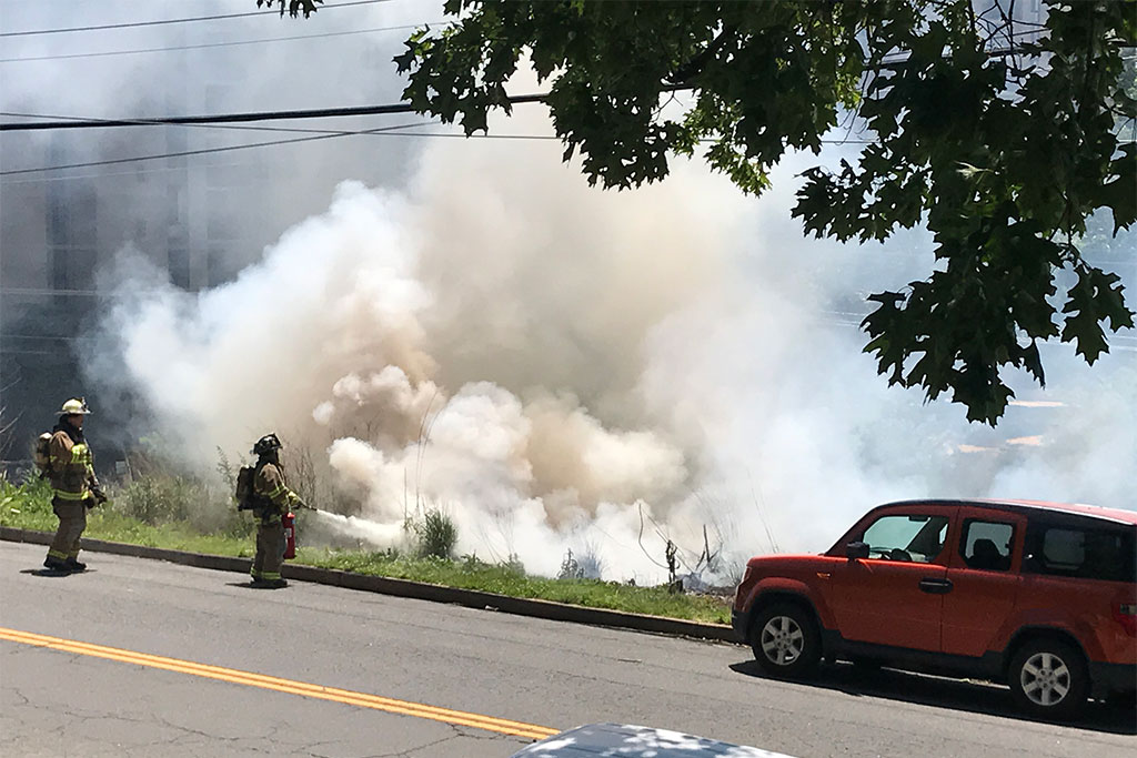
Tree down and brush fire along Four Mile Run Drive in 2017 (photo courtesy John Chandler)
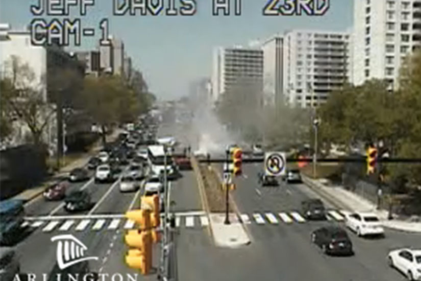
Brush fire in Crystal City in 2016
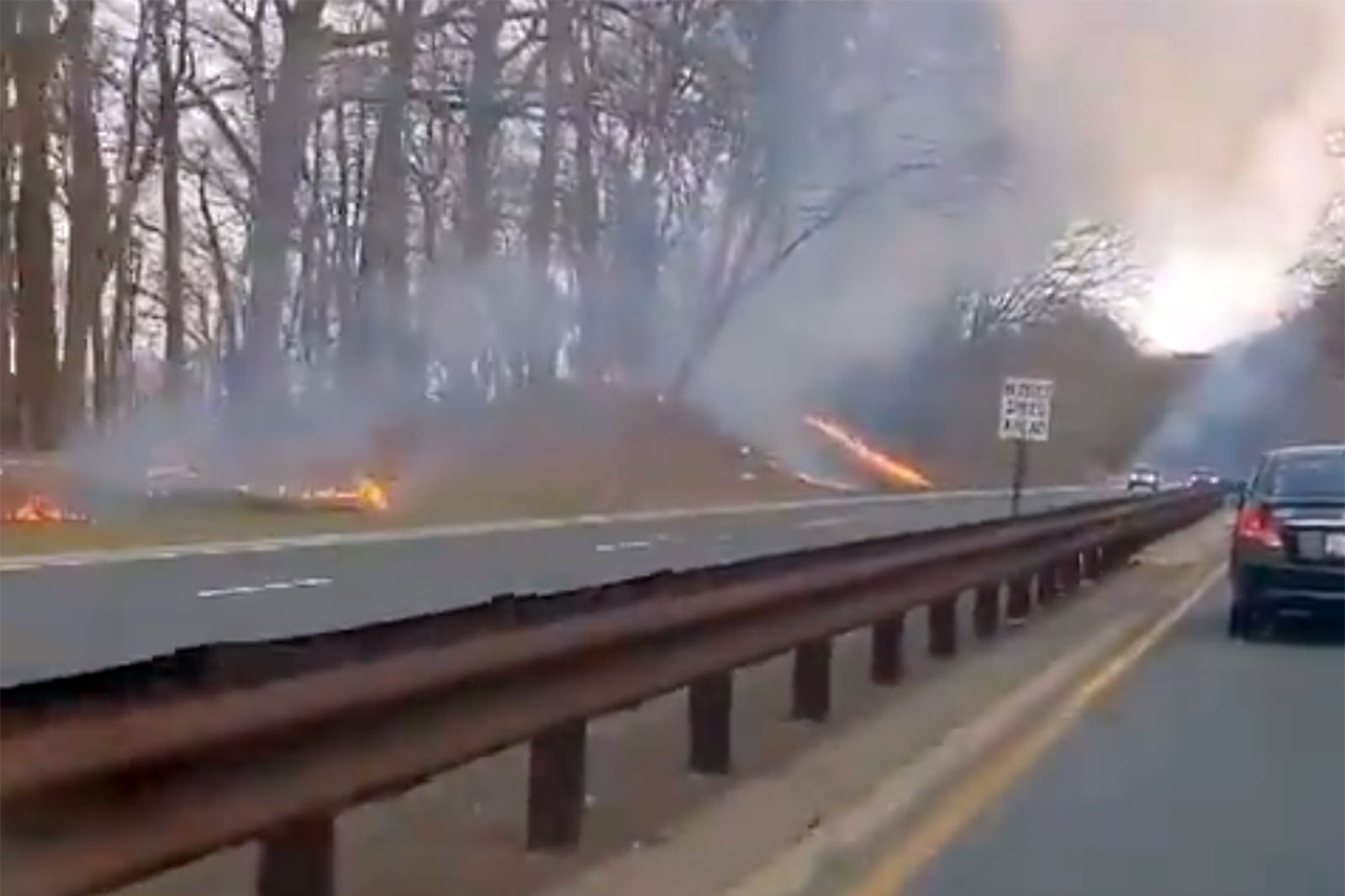
Multiple brush fires along the GW Parkway in 2021 (Screenshot via @bramblerambles/Twitter)
Tree down and brush fire along Four Mile Run Drive in 2017 (photo courtesy John Chandler)
Updated at 9:40 a.m. — The earlier watch has been upgraded to a Red Flag Warning. From the National Weather Service:
…RED FLAG WARNING IN EFFECT FROM NOON TODAY TO 8 PM EDT THIS EVENING FOR GUSTY WINDS AND LOW HUMIDITY FOR VIRGINIA, SOUTHERN MARYLAND, AND EASTERN WEST VIRGINIA PANHANDLE…
The National Weather Service in Baltimore MD/Washington has issued a Red Flag Warning for gusty winds and low humidity, which is in effect from noon today to 8 PM EDT this evening.
* WINDS…West 15 to 25 mph with gusts up to 35 to 45 mph.
* RELATIVE HUMIDITY…As low as 18 percent.
* IMPACTS…Critical fire weather conditions are expected through this evening. All outdoor burning is discouraged, as fires could rapidly spread and become uncontrollable.
* FUEL MOISTURE…Dropping to around 7 or 8 percent.
PRECAUTIONARY/PREPAREDNESS ACTIONS…
A Red Flag Warning means that critical fire weather conditions are either occurring now, or will shortly. A combination of strong winds, low relative humidity, and warm temperatures can contribute to extreme fire behavior.
A Red Flag Warning is in effect for most areas south of I-68/I-70 from noon until 8PM this evening. A Red Flag Warning means warm temperatures, very low humidity, & strong winds are expected to produce an increased risk of fire danger. For more, visit: https://t.co/5RyZgpfrqr. pic.twitter.com/bliRAqJlwv
— NWS Baltimore-Washington (@NWS_BaltWash) April 18, 2023
Earlier: Arlington County, along with much of the D.C. area, will be under a Fire Weather Watch tomorrow.
Small brush fires are not uncommon in Arlington, though at no point in recent history has one threatened a home, as happened in D.C. last month.
Forecasters say Tuesday’s weather will be windy with low humidity — ideal for the spread of brush fires.
A Fire Weather Watch has been issued for a majority of the region Tuesday afternoon & evening. West winds gusting 30 to 40 mph combined with low minimum RH values will yield elevated fire weather concerns. Please avoid any burning during this time. #MDwx#VAwx#WVwx#DCwxpic.twitter.com/3bu0C5UzL6
— NWS Baltimore-Washington (@NWS_BaltWash) April 17, 2023
Severe Thunderstorm Watch map on 4/6/23 (via National Weather Service)
Arlington and much of the D.C. area is now under a Severe Thunderstorm Watch.
The watch is in effect until 10 p.m.
Forecasters say today’s sunshine and warmth may fuel strong storms starting this afternoon. Damaging winds and hail are possible through the evening hours.
A Severe Thunderstorm Watch has been issued for areas along & east of the Blue Ridge through 10 pm EDT. Primary threats include scattered gusts up to 70 mph along with isolated large hail. #MDwx#VAwx#WVwx#DCwxpic.twitter.com/Oi40DcLAwg
— NWS Baltimore-Washington (@NWS_BaltWash) April 6, 2023
Shower and storm coverage will increase later this afternoon and evening especially in areas along and east of the Blue Ridge. Damaging winds and hail will be possible with storms that form between 3-9pm. #MDwx#VAwx#WVwx#DCwxhttps://t.co/0RGf8fkT4A
— NWS Baltimore-Washington (@NWS_BaltWash) April 6, 2023
Flags blowing in the wind at Arlington County government headquarters (staff photo by Jay Westcott)
(Updated at 9:15 a.m.) Batten down the hatches, it’s going to get pretty windy Saturday.
The National Weather Service has upgraded the earlier High Wind Watch for Arlington to a High Wind Warning, in effect Saturday from noon to midnight.
Forecasters say gusts of up to 60 mph could fell trees, knock out power to parts of the area, and make travel treacherous.
More from NWS:
…HIGH WIND WARNING REMAINS IN EFFECT FROM NOON SATURDAY TO MIDNIGHT EDT SATURDAY NIGHT…
* WHAT…Southwest winds 20 to 30 mph with gusts up to 50 mph Saturday afternoon, becoming northwest 25 to 35 mph with gusts up to 60 mph Saturday evening.
* WHERE…Portions of central and northern Maryland, The District of Columbia, and northern Virginia.
* WHEN…From noon Saturday to midnight EDT Saturday night. The strongest winds are expected Saturday evening.
* IMPACTS…Damaging winds will blow down trees and power lines. Widespread power outages are expected. Travel will be difficult, especially for high profile vehicles.
The expected weather is already postponing outdoor events, like National Landing’s Pink in the Park event.
Damaging winds are expected on Saturday. High Wind Warnings are in effect for most of the region for gusts up to 65 mph. Wind Advisories remain for areas generally south of I-66 for gusts up 55 mph. Secure loose objects and prepare for power outages. #MDwx#VAwx#WVwx#DCwxpic.twitter.com/9PJyMWIMQ7
— NWS Baltimore-Washington (@NWS_BaltWash) April 1, 2023
Flood Watch graphic (Photo via National Weather Service/Twitter)
Arlington County, D.C. and its immediate neighbors are under a Flood Watch starting early Monday morning.
Heavy rain is expected overnight and during the morning commute. The soaking rainfall may cause isolated flooding.
More from the National Weather Service:
…FLOOD WATCH IN EFFECT FROM 4 AM EDT TUESDAY THROUGH TUESDAY AFTERNOON…
* WHAT…Flash flooding caused by excessive rainfall is possible.
* WHERE…Portions of DC, Maryland and northern Virginia, including the following areas: in DC, District of Columbia. In Maryland, Anne Arundel, Carroll, Cecil, Central and Southeast Howard, Central and Southeast Montgomery, Frederick MD, Northern Baltimore, Northwest Harford, Northwest Howard, Northwest Montgomery, Prince Georges, Southeast Harford and Southern Baltimore. In northern Virginia, Arlington/Falls Church/Alexandria, Eastern Loudoun, Fairfax and Western Loudoun.
* WHEN…From 4 AM EDT Tuesday through Tuesday afternoon.
* IMPACTS…Excessive runoff may result in flooding of rivers, creeks, streams, and other low-lying and flood-prone locations.
* ADDITIONAL DETAILS…
– An area of low pressure is expected to develop along a slow moving boundary draped across the region Tuesday morning through early Tuesday afternoon. Heavy showers and a few thunderstorms are expected to drop 2 to 3 inches across much of the watch area, with isolated higher amounts up to 5 inches possible in the heaviest cells.
– http://www.weather.gov/safety/flood
PRECAUTIONARY/PREPAREDNESS ACTIONS…
You should monitor later forecasts and be prepared to take action should Flash Flood Warnings be issued.
More via social media:
9:40 pm: Plan ahead! Flood watch issued for much of DC area (dark green shading on map) starting at 4 a.m. Tuesday. A few inches of rain possible in a short period of time during the morning commute. See our detailed forecast: https://t.co/igRH3PBYrJpic.twitter.com/I3k2pJuHxL
#NEW: A Flood Watch has been issued for the DC/Baltimore metro areas from 4AM-2PM Tuesday. 1-3 inches of rain is expected with up to 5 inches possible with heavier showers and storms. Turn around, don’t drown. #vawx#mdwx#dcwxpic.twitter.com/7YyhBRr14s
Heavy rain along Four Mile Run Drive near Shirlington (file photo by Jay Westcott)
Arlington — along with D.C., Alexandria, Fairfax County and most of the rest of Northern Virginia — is under a Flood Watch today.
The watch takes effect at 2 p.m. and will remain in effect into the evening hours as slow-moving storms roll into the area.
The combination of slow storm movement and the potential for training — a series of downpours focused on a specific west-to-east area — raises the possibility of flooding, forecasters say.
More from the National Weather Service:
…FLOOD WATCH REMAINS IN EFFECT FROM 2 PM EDT THIS AFTERNOON THROUGH THIS EVENING…
* WHAT…FLASH FLOODING CAUSED BY EXCESSIVE RAINFALL CONTINUES TO BE POSSIBLE. […]
* IMPACTS…EXCESSIVE RUNOFF MAY RESULT IN FLOODING OF RIVERS, CREEKS, STREAMS, AND OTHER LOW-LYING AND FLOOD-PRONE LOCATIONS.
* ADDITIONAL DETAILS…
– SHOWERS AND NUMEROUS THUNDERSTORMS ARE EXPECTED THIS AFTERNOON INTO THIS EVENING. RAINFALL AMOUNTS WILL AVERAGE AROUND 1 TO 1.5 INCHES ACROSS THE AREA, BUT LOCALLY HIGHER AMOUNTS OF 2 TO 4 INCHES ARE LIKELY AND MUCH OF THAT MAY FALL IN A ONE TO TWO HOUR TIMEFRAME. HEAVY RAIN IN SHORT PERIODS OF TIME MAY CAUSE CREEKS AND STREAMS TO RAPIDLY RISE OUT OF THEIR BANKS ALONG WITH POTENTIAL FLASH FLOODING IN URBAN AREAS.
– HTTP://WWW.WEATHER.GOV/SAFETY/FLOOD
PRECAUTIONARY/PREPAREDNESS ACTIONS…
YOU SHOULD MONITOR LATER FORECASTS AND BE PREPARED TO TAKE ACTION SHOULD FLASH FLOOD WARNINGS BE ISSUED.
Showers and thunderstorms are likely later this afternoon and evening which may produce locally heavy rainfall. A Flood Watch has been issued for DC/Balt metro areas and SW into northern VA and the Potomac Highlands of VA/WV to account for the potential for flash flooding. pic.twitter.com/qRlPK8L4YV
Slow-moving storms this afternoon and evening may pack downpours that could cause flooding, forecasters say.
The National Weather Service just issued a Flood Watch for Arlington, the District and most of the region as a result.
From NWS:
1020 AM EDT Fri Aug 5 2022
…FLOOD WATCH IN EFFECT FROM 3 PM EDT THIS AFTERNOON THROUGH THIS EVENING…
* WHAT…Flash flooding caused by excessive rainfall is possible. […]
* WHEN…From 3 PM EDT this afternoon through this evening.
* IMPACTS…Excessive runoff may result in flooding of rivers, creeks, streams, and other low-lying and flood-prone locations.
* ADDITIONAL DETAILS…
– Showers and thunderstorms will develop this afternoon and may last into the evening. Any thunderstorms will be capable of producing very heavy rainfall, with localized totals of two to four inches possible. Much of the rain may fall within a one to three hour period, making rapid rises in creeks and streams possible, as well as flash flooding in urban areas.
– http://www.weather.gov/safety/flood
PRECAUTIONARY/PREPAREDNESS ACTIONS…
You should monitor later forecasts and be prepared to take action should Flash Flood Warnings be issued.
Boundaries of Severe Thunderstorm Watch on 7/25/22 (via National Weather Service)
Update at 3:50 p.m. — A Severe Thunderstorm Warning has been issued for the far northern tip of Arlington.
Severe Thunderstorm Warning for DC, Montgomery, Prince Georges, Arlington, and Fairfax counties until 4:30PM. Main hazards are 60mph wind gusts and quarter size hail. #vawx#dcwx#mdwxpic.twitter.com/3TnBKyYKUY
— Washingtonian Weather Geeks (@WashingtonianWx) July 25, 2022
Earlier: Arlington, D.C. and most of the region is now under a Severe Thunderstorm Watch.
The watch, which was issued around 1:45 p.m., is in effect until 10 p.m.
Forecasters say storms packing damaging winds and heavy downpours are possible this afternoon and evening. More from NWS:
Thunderstorms will further develop and intensify initially near/just of the mountains, and subsequently spread eastward toward the I-95 corridor through late afternoon and early evening. Damaging winds are the primary hazard.
A Severe Thunderstorm Watch is in effect for areas along and east of I-81 through 10 PM tonight. Main impacts will be damaging winds. A localized flood threat exists as well with rainfall rates of 1-2"/hr possible in any stronger thunderstorms over a short period of time. pic.twitter.com/6QqD8L4ssZ
— NWS Baltimore-Washington (@NWS_BaltWash) July 25, 2022
A severe thunderstorm watch has been issued for parts of DE, DC, MD, NJ, PA, VA, WV until 10 PM EDT pic.twitter.com/EbdNHbuIcu
— NWS Severe Tstorm (@NWSSevereTstorm) July 25, 2022
Local authorities, meanwhile, are encouraging residents to prepare for the possibility of severe weather.
Some of the tips include charging essential devices and securing loose items from lawns and balconies.
Update at 1:50 p.m. — A Severe Thunderstorm Watch was just issued for parts of the D.C. area, including Arlington, and much of the D.C.-Baltimore-Philly-NYC corridor. That’s in addition to the Flood Watch, below.
From the National Weather Service:
Scattered severe thunderstorms are possible this afternoon and evening, mainly north of the D.C. metro area. Damaging wind gusts are the primary threat with an isolated tornado also possible.
A severe thunderstorm watch has been issued for parts of CT, DE, DC, MD, NJ, NY, PA, VA, WV until 10 PM EDT pic.twitter.com/eal2Prh0i3
— NWS Severe Tstorm (@NWSSevereTstorm) July 18, 2022
Earlier: It’s the middle of July and the humidity level outside is roughly that of an unventilated bathroom after a half-hour hot shower.
Unsurprisingly, that combination is a recipe for possible downpours — and flooding — tonight.
The National Weather Service just issued a Flood Watch, which will go into effect at 4 p.m. Forecasters say “multiple rounds of storms” could cause flooding later today.
There is a marginal risk of severe weather this afternoon and evening from @NWSSPC. Damaging winds are the primary threat, though isolated instances of flooding are possible. #DCwx#MDwx#VAwx#WVwxpic.twitter.com/MxVvFeR5NO
— NWS Baltimore-Washington (@NWS_BaltWash) July 18, 2022
More from NWS:
FLOOD WATCH
NATIONAL WEATHER SERVICE BALTIMORE MD/WASHINGTON DC
931 AM EDT MON JUL 18 2022
…FLOOD WATCH IN EFFECT FROM 4 PM EDT THIS AFTERNOON THROUGH THIS EVENING…
* WHAT…FLASH FLOODING CAUSED BY EXCESSIVE RAINFALL IS POSSIBLE.
* WHERE…PORTIONS OF DC, MARYLAND AND NORTHERN VIRGINIA […]
* WHEN…FROM 4 PM EDT THIS AFTERNOON THROUGH THIS EVENING.
* IMPACTS…EXCESSIVE RUNOFF MAY RESULT IN FLOODING OF RIVERS, CREEKS, STREAMS, AND OTHER LOW-LYING AND FLOOD-PRONE LOCATIONS.
* ADDITIONAL DETAILS…
– AFTERNOON TO EVENING SHOWERS AND THUNDERSTORMS MAY PRODUCE VERY HEAVY RAINFALL CAPABLE OF FLASH FLOODING. THIS COULD INCLUDE MULTIPLE ROUNDS OF STORMS WHICH WOULD ENHANCE THE FLOOD RISK. RAINFALL RATES MAY REACH 1 TO 2 INCHES PER HOUR, LOCALLY HIGHER IN SPOTS. THE D.C. AND BALTIMORE METROS WILL BE THE MOST SUSCEPTIBLE GIVEN RECENT HEAVY RAINFALL THE PAST COUPLE OF WEEKS.
– HTTP://WWW.WEATHER.GOV/SAFETY/FLOOD
PRECAUTIONARY/PREPAREDNESS ACTIONS…
YOU SHOULD MONITOR LATER FORECASTS AND BE PREPARED TO TAKE ACTION SHOULD FLASH FLOOD WARNINGS BE ISSUED.
Updated at 2:15 p.m. — A Severe Thunderstorm Watch was also just issued for the area.
A severe thunderstorm watch has been issued for parts of District of Columbia, Maryland, Virginia and West Virginia until 10 PM EDT pic.twitter.com/SpwWlujlua
— NWS Severe Tstorm (@NWSSevereTstorm) July 12, 2022
Numerous strong to severe thunderstorms are expected as a cold front pushes through. Damaging winds is the main threat but large hail, an isolated tornado or two, and flash flooding is also possible. Stay weather aware today! #vawx#mdwx#dcwx#wvwxpic.twitter.com/OBK65Xt9OS
— Washingtonian Weather Geeks (@WashingtonianWx) July 12, 2022
Earlier: Arlington and much of the D.C. and Baltimore area is under a Flood Watch today, starting at 4 p.m.
Storms are expected later today, forecasters say. Heavy rain and strong winds are likely.
“Scattered severe thunderstorms are possible this afternoon and evening,” the National Weather Service says. “Damaging wind gusts and large hail are the primary threats. An isolated tornado is also possible.”
More on the Flood Watch from NWS, below.
…FLOOD WATCH IN EFFECT FROM 4 PM EDT THIS AFTERNOON THROUGH THIS EVENING…
* WHAT…Flash flooding caused by excessive rainfall is possible.
* WHERE…Portions of DC, Maryland and northern Virginia, including the following areas: in DC, District of Columbia. In Maryland, Anne Arundel, Central and Southeast Howard, Central and Southeast Montgomery, Northern Baltimore, Northwest Howard, Northwest Montgomery, Prince George’s and Southern Baltimore. In northern Virginia, Arlington/Falls Church/Alexandria, Fairfax and Prince William/Manassas/Manassas Park.
* WHEN…From 4 PM EDT this afternoon through this evening.
* IMPACTS…Excessive runoff may result in flooding of rivers, creeks, streams, and other low-lying and flood-prone locations. Creeks and streams may rise out of their banks.
* ADDITIONAL DETAILS…
– Strong to severe thunderstorms will move across the region late this afternoon through the evening hours. Heavy rain will accompany a number of these storms which may drop 1 to 2 inches of rainfall in an hour. Additionally, some regions could see repeat thunderstorm activity leading to an enhanced threat for flooding.
– http://www.weather.gov/safety/flood
PRECAUTIONARY/PREPAREDNESS ACTIONS…
You should monitor later forecasts and be prepared to take action should Flash Flood Warnings be issued.
A Flash Flood Watch is in effect late this afternoon through midnight tonight to account for increased rainfall amounts in and around the DC/Baltimore metropolitan areas. pic.twitter.com/2jotb79sJV
— NWS Baltimore-Washington (@NWS_BaltWash) July 12, 2022
Flood Watch map 7/8/22 (via National Weather Service)
Arlington and much of the D.C. area will be under a Flood Watch starting tonight.
Heavy rain and storms are expected tonight. The rain is expected to persist through Saturday afternoon, raising the possibility of flooding, including flash flooding caused by “excessive rainfall.”
The Flood Watch takes effect at 11 p.m.
From the National Weather Service:
URGENT – IMMEDIATE BROADCAST REQUESTED
FLOOD WATCH
NATIONAL WEATHER SERVICE BALTIMORE MD/WASHINGTON DC
1253 PM EDT FRI JUL 8 2022
…FLOOD WATCH IN EFFECT FROM 11 PM EDT THIS EVENING THROUGH SATURDAY AFTERNOON…
* WHAT…FLASH FLOODING CAUSED BY EXCESSIVE RAINFALL IS POSSIBLE.
* WHERE…WASHINGTON DC, MARYLAND AND NORTHERN VIRGINIA, INCLUDING THE FOLLOWING AREAS: IN DC, DISTRICT OF COLUMBIA. IN MARYLAND, ANNE ARUNDEL, CARROLL, CENTRAL AND SOUTHEAST HOWARD, CENTRAL AND SOUTHEAST MONTGOMERY, FREDERICK MD, NORTHERN BALTIMORE, NORTHWEST HARFORD, NORTHWEST HOWARD, NORTHWEST MONTGOMERY, PRINCE GEORGES, SOUTHEAST HARFORD AND SOUTHERN BALTIMORE. IN NORTHERN VIRGINIA, ARLINGTON/FALLS CHURCH/ALEXANDRIA, EASTERN LOUDOUN, FAIRFAX, PRINCE WILLIAM/MANASSAS/MANASSAS PARK AND WESTERN LOUDOUN.
* WHEN…FROM 11 PM EDT THIS EVENING THROUGH SATURDAY AFTERNOON.
* IMPACTS…EXCESSIVE RUNOFF MAY RESULT IN FLOODING OF RIVERS, CREEKS, STREAMS, AND OTHER LOW-LYING AND FLOOD-PRONE LOCATIONS.
* ADDITIONAL DETAILS…
– SHOWERS ARE EXPECTED WITH SCATTERED THUNDERSTORMS LATE THIS EVENING INTO MIDDAY SATURDAY. AVERAGE RAINFALL AMOUNTS AROUND 1 TO 3 INCHES ARE EXPECTED, BUT LOCALIZED AMOUNTS AROUND 4 TO 7 INCHES IN HEAVIER SHOWERS AND THUNDERSTORMS. RAINFALL AMOUNTS AROUND 1 TO 3 INCHES WITHIN AN HOUR OR TWO ARE POSSIBLE IN AREAS WHERE THE HEAVIEST RAINFALL OCCURS. THE BEST CHANCE FOR THE HEAVIEST RAINFALL WILL BE OVERNIGHT INTO SATURDAY MORNING.


")
")
")
")
")
")
")
")
")