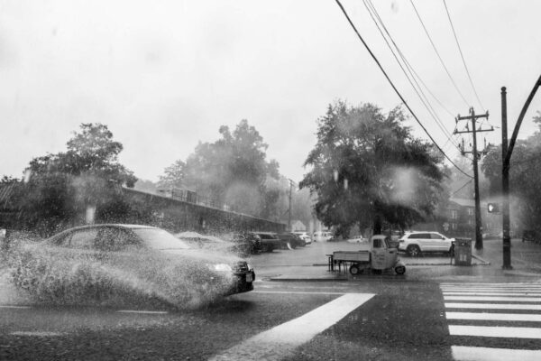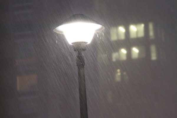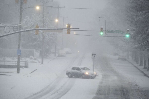
Snow in Westover on Jan. 3, 2022 (staff photo by Jay Westcott)

Arlington — and much of the D.C. region — is now officially under a Winter Storm Watch.

The watch was issued just before 3 p.m. Forecasters are calling for up to 5 inches of accumulating snow, but 1-3 inches is most likely, according to the National Weather Service.

Gusty winds will accompany the storm and, paired with the snowfall, could fell tree branches and cause another bout of power outages.

From NWS:

URGENT – WINTER WEATHER MESSAGE
National Weather Service Baltimore MD/Washington DC
251 PM EST Fri Jan 14 2022

…WINTER STORM WATCH IN EFFECT FROM SUNDAY AFTERNOON THROUGH MONDAY MORNING…

* WHAT…Significant snow and wintry precipitation possible. Total snow accumulations of 1 to 3 inches are most likely, with up to 5 inches possible. Ice accumulations of up to one tenth of an inch are possible. Winds could gust as high as 45 mph.

* WHERE…The District of Columbia, portions of central and northern Maryland, and central and northern Virginia.

* WHEN…From Sunday afternoon through Monday morning.

* IMPACTS…Plan on slippery road conditions. The hazardous conditions could impact the Monday morning commute.

* ADDITIONAL DETAILS…Snow may fall at 1 to 3 inches per hour late Sunday afternoon and early Sunday evening, resulting in nearly impassable roads.

PRECAUTIONARY/PREPAREDNESS ACTIONS…

Monitor the latest forecasts for updates on this situation.

Ahead of the storm, which is expected to have more severe impacts west of the D.C. area, Virginia Gov. Ralph Northam today declared a state of emergency.

“We expect this storm to have a significant impact in many parts of Virginia,” Northam said in a statement. “Declaring a state of emergency now allows our emergency responders to prepare, and to move supplies and equipment where they expect to need them the most. This also gives Governor-elect Youngkin the ability to respond to any storm needs swiftly. I urge Virginians to take this storm seriously and make preparations now.”

Arlington County and VDOT crews, meanwhile, have been pre-treating roads in advance of the winter weather, which is expected to start as snow Saturday afternoon before transitioning to sleet, freezing rain and then plain rain.

https://twitter.com/VaDOTNOVA/status/1482081483644973059


Update at 3:15 p.m. — Both Arlington County and VDOT say snow crews are preparing for the storm.

“Throughout overnight hours, crews and about 2,200 trucks will be staged and ready to treat roads and plow snow where needed,” VDOT said Sunday afternoon. “Crews will begin to plow once two inches of snow have accumulated.”

Update at 2:50 p.m. — The earlier Winter Storm Watch has been updated to a Winter Storm Warning. The forecast still calls for 3 or more inches of snow falling Monday morning.

233 PM EST Sun Jan 2 2022

…WINTER STORM WARNING IN EFFECT FROM 1 AM TO 4 PM EST MONDAY…

* WHAT…Heavy snow. Total snow accumulations of 3 to 7 inches. Winds gusting as high as 35 mph.

* WHERE…The District of Columbia, portions of central Maryland and northern Virginia.

* WHEN…From 1 AM to 4 PM EST Monday.

* IMPACTS…Travel could be very difficult. The hazardous conditions could impact the morning or evening commute.

PRECAUTIONARY/PREPAREDNESS ACTIONS…

If you must travel, keep an extra flashlight, food, and water in your vehicle in case of an emergency.

When venturing outside, watch your first few steps taken on steps, sidewalks, and driveways, which could be icy and slippery, increasing your risk of a fall and injury.

Earlier: Arlington and the D.C. area could get the first significant snowfall of the season tomorrow.

Heavy snow with up to 3-6 inches of accumulation is possible Monday, starting late tonight, according to the National Weather Service, which issued a Winter Storm Watch for Arlington County and other parts of the region early this morning.

Arlington is just on the northern edge of the Winter Storm Watch, meaning that southern parts of the county may get more snow than northern parts.

More from NWS:

428 AM EST Sun Jan 2 2022

…WINTER STORM WATCH IN EFFECT FROM LATE TONIGHT THROUGH MONDAY AFTERNOON…

* WHAT…Heavy snow possible. Total snow accumulations of 3 to 6 inches possible.

* WHERE…Portions of The District of Columbia, central and southern Maryland and central and northern Virginia.

* WHEN…From late tonight through Monday afternoon.

* IMPACTS…Plan on slippery road conditions. The hazardous conditions could impact the morning commute.

PRECAUTIONARY/PREPAREDNESS ACTIONS…

Monitor the latest forecasts for updates on this situation.


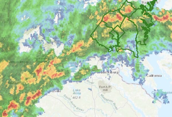
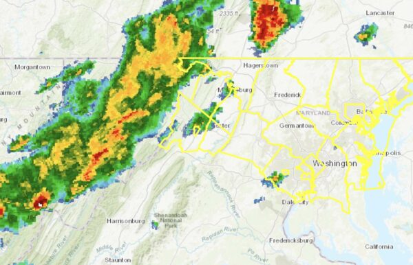
Flash Flood Watch and radar as of 6 p.m. (via NWS)

Update at 10:15 p.m. — Arlington is under a Flood Warning as heavy rain continues to fall. Some flooding is being reported in parts of the area, including along I-66 in Arlington.

Earlier: A rainy night, and possible flooding, is on tap after a line of storms packing gusty winds and downpours blew through Arlington during the evening commute.

More rain is expected to fall on already-saturated ground tonight, prompting the National Weather Service to issue a Flash Flood Watch.

More from NWS:

URGENT – IMMEDIATE BROADCAST REQUESTED
FLOOD WATCH
NATIONAL WEATHER SERVICE BALTIMORE MD/WASHINGTON DC
550 PM EDT MON OCT 25 2021

…FLASH FLOOD WATCH IN EFFECT UNTIL 2 AM EDT TUESDAY…

THE NATIONAL WEATHER SERVICE IN STERLING VIRGINIA HAS ISSUED A

* FLASH FLOOD WATCH FOR PORTIONS OF DC, MARYLAND AND NORTHERN VIRGINIA, INCLUDING THE FOLLOWING AREAS: IN DC, DISTRICT OF COLUMBIA. IN MARYLAND, ANNE ARUNDEL, CENTRAL AND SOUTHEAST HOWARD, CENTRAL AND SOUTHEAST MONTGOMERY, PRINCE GEORGES AND SOUTHERN BALTIMORE. IN NORTHERN VIRGINIA, ARLINGTON/FALLS CHURCH/ALEXANDRIA AND FAIRFAX.

* UNTIL 2 AM EDT TUESDAY.

* SHOWERS AND THUNDERSTORMS ARE EXPECTED TO PRODUCE 1 TO 2 INCHES OF RAIN THROUGH THIS EVENING, WITH LOCALIZED AMOUNTS OF UP TO 4 INCHES POSSIBLE. HEAVY RAIN IN A SHORT AMOUNT OF TIME MAY RESULT IN RAPID RISES OF WATER ON SMALL CREEKS AND STREAMS AND IN URBAN AREAS.

PRECAUTIONARY/PREPAREDNESS ACTIONS…

YOU SHOULD MONITOR LATER FORECASTS AND BE PREPARED TO TAKE ACTION SHOULD FLASH FLOOD WARNINGS BE ISSUED.


A rainy night and morning are on tap for Arlington, leading the National Weather Service to issue a Flash Flood Watch.

D.C., Alexandria and points north and west are also included in the watch.

More from NWS:

146 PM EDT WED SEP 22 2021

…FLASH FLOOD WATCH IN EFFECT FROM LATE TONIGHT THROUGH THURSDAY AFTERNOON…

THE NATIONAL WEATHER SERVICE IN STERLING VIRGINIA HAS EXPANDED THE

* FLASH FLOOD WATCH TO INCLUDE PORTIONS OF DC, MARYLAND AND NORTHERN VIRGINIA, INCLUDING THE FOLLOWING AREAS: IN DC, DISTRICT OF COLUMBIA. IN MARYLAND, CARROLL, CECIL, CENTRAL AND SOUTHEAST HOWARD, CENTRAL AND SOUTHEAST MONTGOMERY, NORTHERN BALTIMORE, NORTHWEST HARFORD, NORTHWEST HOWARD, NORTHWEST MONTGOMERY, SOUTHEAST HARFORD AND SOUTHERN BALTIMORE. IN NORTHERN VIRGINIA, ARLINGTON/FALLS CHURCH/ALEXANDRIA, EASTERN LOUDOUN AND FAIRFAX.

* FROM LATE TONIGHT THROUGH THURSDAY AFTERNOON.

* MULTIPLE ROUNDS OF SHOWERS AND SCATTERED THUNDERSTORMS CAPABLE OF PRODUCING HEAVY RAIN ARE EXPECTED THROUGH THURSDAY AFTERNOON. THE MOST WIDESPREAD HEAVY RAIN IS MOST LIKELY LATE TONIGHT THROUGH EARLY THURSDAY AFTERNOON. AVERAGE RAINFALL AMOUNTS OF 1 TO 2 INCHES ARE EXPECTED, WITH LOCALIZED HIGHER AMOUNTS OF UP TO 4 INCHES POSSIBLE. HEAVY RAIN FALLING OVER INCREASINGLY SATURATED GROUND MAY RESULT IN FLASH FLOODING.

PRECAUTIONARY/PREPAREDNESS ACTIONS…

YOU SHOULD MONITOR LATER FORECASTS AND BE PREPARED TO TAKE ACTION SHOULD FLASH FLOOD WARNINGS BE ISSUED.

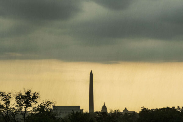
File photo


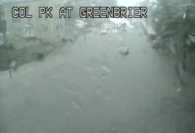
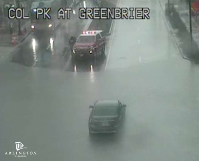
(Updated at 4:50 p.m.) Floodwaters have receded after Columbia Pike was blocked at S. Greenbrier Street around 3:30 this afternoon.

At least one car was stuck in the high water, near the 55 Hundred apartments, just west of the county line, prompting a water rescue operation. Other traffic could be seen turning around.

Firefighters successfully rescued the driver of the vehicle that was stuck, according to scanner traffic.

https://twitter.com/News_MTorres/status/1438602239594094593

Reports of flooding came as the National Weather Service issued a new Flood Warning for the county. Just before 4 p.m., a Flash Flood Warning was also issued.

From NWS:

THE NATIONAL WEATHER SERVICE IN STERLING VIRGINIA HAS ISSUED A

* FLOOD WARNING…

* UNTIL 930 PM EDT THURSDAY.

* AT 321 PM EDT, DOPPLER RADAR INDICATED HEAVY RAIN DUE TO THUNDERSTORMS. FLOODING IS ONGOING OR EXPECTED TO BEGIN SHORTLY IN THE WARNED AREA. BETWEEN 1 AND 1.5 INCHES OF RAIN HAVE FALLEN.

* SOME LOCATIONS THAT WILL EXPERIENCE FLOODING INCLUDE… ARLINGTON… ALEXANDRIA… BETHESDA… RESTON… ANNANDALE… SPRINGFIELD… FORT WASHINGTON… FAIRFAX… LANGLEY PARK… FORT HUNT… VIENNA… GROVETON… FALLS CHURCH… HUNTINGTON… CORAL HILLS… BLADENSBURG… MANTUA… PIMMIT HILLS… NATIONAL HARBOR… ROSSLYN…

ADDITIONAL RAINFALL AMOUNTS OF 1 TO 2 INCHES ARE POSSIBLE IN THE WARNED AREA.

PRECAUTIONARY/PREPAREDNESS ACTIONS…

TURN AROUND, DON’T DROWN WHEN ENCOUNTERING FLOODED ROADS. MOST FLOOD DEATHS OCCUR IN VEHICLES.

In addition to the Pike flooding, high standing water was reported along I-395.

Previously, NWS issued a Flash Flood Watch for the area, effective until 9 p.m.

The rain has already cancelled at least one local event, a pop-up jazz performance in Rosslyn.


(Updated at 9:25 p.m.) Arlington County and the immediate D.C. area, as well as points north, are under a Severe Thunderstorm Watch tonight.

The watch is in effect until midnight. Forecasters say an approaching cold front will bring storms and potentially damaging winds to the area over the next few hours. Heavy rain and hail are also expected.

Just before 9:30 p.m., a Flash Flood Watch was also issued for Arlington. The watch is in effect until 4 a.m.

More from the National Weather Service:

924 PM EDT WED SEP 8 2021

…FLASH FLOOD WATCH IN EFFECT UNTIL 4 AM EDT THURSDAY…

THE NATIONAL WEATHER SERVICE IN STERLING VIRGINIA HAS EXPANDED THE

* FLASH FLOOD WATCH TO INCLUDE PORTIONS OF DC, CENTRAL MARYLAND AND NORTHERN VIRGINIA, INCLUDING THE FOLLOWING AREAS: IN DC, DISTRICT OF COLUMBIA. IN CENTRAL MARYLAND, ANNE ARUNDEL AND PRINCE GEORGES. IN NORTHERN VIRGINIA, ARLINGTON/FALLS CHURCH/ALEXANDRIA, EASTERN LOUDOUN, FAIRFAX, PRINCE WILLIAM/MANASSAS/MANASSAS PARK AND WESTERN LOUDOUN.

* UNTIL 4 AM EDT THURSDAY.

* SHOWERS AND SCATTERED THUNDERSTORMS ARE EXPECTED TONIGHT. AVERAGE RAINFALL AMOUNTS OF ONE-HALF TO ONE INCH IS EXPECTED. HOWEVER, THUNDERSTORMS WILL CONTAIN VERY HEAVY RAINFALL WITH RAINFALL RATES AROUND 1 TO 3 INCHES PER HOUR. LOCALIZED RAINFALL AMOUNTS OF 2 TO 4 INCHES ARE POSSIBLE.

* HEAVY AMOUNTS OF RAIN IN A SHORT PERIOD OF TIME MAY CAUSE CREEKS AND STREAMS TO RAPIDLY RISE OUT OF THEIR BANKS AS WELL AS THE POTENTIAL FOR FLASH-FLOODING IN URBAN AREAS.

PRECAUTIONARY/PREPAREDNESS ACTIONS…

YOU SHOULD MONITOR LATER FORECASTS AND BE PREPARED TO TAKE ACTION SHOULD FLASH FLOOD WARNINGS BE ISSUED.


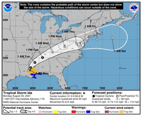
Expected track of the remnants of Hurricane Ida (via National Weather Service)

(Updated at noon) The remnants of Hurricane Ida are heading our way, and forecasters are already warning of potential flooding.

Ida has ravaged portions of Louisiana and Mississippi since making landfall as a Category 4 storm Sunday afternoon. It knocked out power to more than a million homes and businesses, including the entire city of New Orleans; interrupted 911 service; and caused catastrophic flooding, prompting numerous water rescues.

Now a tropical storm, Ida is on a northeasterly track that is expected to put its remnants squarely over the D.C. area starting Wednesday.

Two days ahead of Ida’s arrival, the National Weather Service this morning issued a Flash Flood Watch, to take effect from 11 a.m. Wednesday to 8 a.m. Thursday. Some 2-5 inches of rain could fall during that time.

Forecasters are also warning of the potential for severe weather or even tornadoes spawned by Ida.

“Heavy tropical rainfall could result in considerable flash flooding,” NWS wrote. “A few severe thunderstorms are possible Wednesday into Wednesday night. Damaging wind gusts and a brief tornado are the main threats.”

More from NWS:

…FLASH FLOOD WATCH IN EFFECT FROM WEDNESDAY MORNING THROUGH THURSDAY MORNING…

The National Weather Service in Sterling Virginia has issued a

* Flash Flood Watch for portions of DC, Maryland and Virginia…

* From Wednesday morning through Thursday morning.

* The remnants of Ida will interact with a stalled front, resulting in a prolonged period of heavy rainfall beginning Wednesday morning and continuing through Wednesday night. Rainfall amounts of 2 to 4 inches are expected, with localized amounts up to 6 inches possible.

* This amount of heavy rainfall will not only result in the potential for considerable flash flooding of creeks, small streams, and urban areas, but also the potential for river flooding on the main stem rivers.

PRECAUTIONARY/PREPAREDNESS ACTIONS…

You should monitor later forecasts and be prepared to take action should Flash Flood Warnings be issued.

Strong storms are also possible tonight (Monday), with the arrival of a cold front that will end our stretch of sweltering weather and temperatures in the 90s.

“Isolated damaging wind gusts are possible this afternoon and evening,” NWS wrote. “An isolated instance of flooding is also possible.”

Just before noon, a Flash Flood Watch was issued for Monday afternoon.

1148 AM EDT Mon Aug 30 2021

…FLASH FLOOD WATCH IN EFFECT UNTIL 10 PM EDT THIS EVENING…
…FLASH FLOOD WATCH REMAINS IN EFFECT FROM WEDNESDAY MORNING
THROUGH THURSDAY MORNING…

The National Weather Service in Sterling Virginia has issued a

* Flash Flood Watch for portions of DC, Maryland and Virginia…

* Until 10 PM EDT this evening.

* Scattered to numerous showers and thunderstorms are likely this afternoon and evening, some of which may produce a few inches of rain in a short period of time.

* Heavy rainfall in a short period of time would result in rapid rises of water in small streams and creeks, and in urban and poor drainage areas.

PRECAUTIONARY/PREPAREDNESS ACTIONS…

You should monitor later forecasts and be prepared to take action should Flash Flood Warnings be issued.


Get ready for another stormy afternoon — and possible flooding.

The National Weather Service has issued a Flash Flood Watch for Arlington and the immediate D.C. region. The watch, which takes effect at 1 p.m., cautions that heavy rain which can cause dangerous, rapid flooding is expected this afternoon and evening.

Yesterday’s afternoon thunderstorm toppled trees around Arlington and knocked out power to several thousand homes and businesses. No significant flooding was reported locally, but the storm left the ground waterlogged and thus increased the chances of flooding today.

More from NWS:

…FLASH FLOOD WATCH IN EFFECT FROM 1 PM EDT THIS AFTERNOON THROUGH THIS EVENING…

The National Weather Service in Sterling Virginia has issued a

* Flash Flood Watch for portions of DC, central Maryland and northern Virginia, including the following areas: in DC, District of Columbia. In central Maryland, Central and Southeast Howard, Central and Southeast Montgomery and Prince Georges. In northern Virginia, Arlington/Falls Church/Alexandria and Fairfax.

* From 1 PM EDT this afternoon through this evening.

* Numerous showers and thunderstorms are expected this afternoon and evening. Average rainfall amounts are expected to be between one half to one inch. However, thunderstorms will be capable of producing very heavy rainfall rates of 2 to 3 inches per hour, causing localized amounts of 2 to 4 inches possible. While storms are possible any time this afternoon through this evening, the most widespread thunderstorm activity is most likely to be late this afternoon through early this evening.

* Heavy rainfall amounts in a short period of time may result in rapid rises on streams and creeks as well as the potential for flash flooding in urban areas.

PRECAUTIONARY/PREPAREDNESS ACTIONS…

You should monitor later forecasts and be prepared to take action should Flash Flood Warnings be issued.


Arlington is under yet another Flash Flood Watch.

The National Weather Service says that overnight downpours are expected and could cause flash flooding in the D.C. area.

More from NWS:

…FLASH FLOOD WATCH IN EFFECT FROM LATE TONIGHT THROUGH FRIDAY MORNING…

The National Weather Service in Sterling Virginia has issued a

* Flash Flood Watch for portions of DC, central Maryland and Virginia, including the following areas: in DC, District of Columbia. In central Maryland, Central and Southeast Montgomery, Northwest Montgomery and Prince Georges. In Virginia, Albemarle, Arlington/Falls Church/Alexandria, Central Virginia Blue Ridge, Culpeper, Eastern Loudoun, Fairfax, Greene, Madison, Nelson, Northern Fauquier, Northern Virginia Blue Ridge, Orange, Prince William/Manassas/Manassas Park, Rappahannock, Southern Fauquier, Spotsylvania, Stafford and Western Loudoun.

* From 2 AM EDT Friday through Friday morning.

* Scattered to numerous showers and thunderstorms are expected. Although isolated thunderstorms capable of heavy rain are possible this evening near and southwest of the DC metro area, the bulk of the threat is expected to be overnight into Friday morning. Thunderstorms may be capable of producing heavy rainfall of 1 to 2 inches per hour.

* Heavy rainfall may result in rapid rises on streams, creeks, and in urban and poor drainage areas. This will especially be the case where repetitive or persistent thunderstorm activity occurs.

PRECAUTIONARY/PREPAREDNESS ACTIONS…

You should monitor later forecasts and be prepared to take action should Flash Flood Warnings be issued.

Even more rain is expected during the day on Friday and into the weekend.


Tornado Watch area (via National Weather Service)

(Updated at noon) The remnants of Tropical Storm Fred may cause more than just heavy rain today.

Arlington and most of the D.C. area is now under a Tornado Watch. The watch is in effect until 8 p.m.

The area is also under a Flash Flood Watch through 10 p.m. tonight.

Forecasters say conditions are favorable for the formation of tornadoes, though any such storms should be isolated. Severe thunderstorms are also possible.

Arlington is no stranger to tornados, though twisters are a relatively uncommon occurrence.

Last month an EF-1 tornado caused damage across several neighborhoods near Lee Highway. In April 2017, an EF-0 tornado chopped trees in half at Army Navy Country Club and caused some damage at the Macy’s in Pentagon City. Before that, a long-lived EF-1 twister struck Arlington, Alexandria, Fairfax County and D.C. in 2001.

More from the National Weather Service:

A FLASH FLOOD WATCH REMAINS IN EFFECT THROUGH 10 PM FOR AREAS ALONG THE INTERSTATE 95 CORRIDOR. ISOLATED INSTANCES OF FLASH FLOODING ARE POSSIBLE AS TROPICAL MOISTURE OVERSPREADS THE REGION.

A TORNADO WATCH IS IN EFFECT UNTIL 8 PM. ISOLATED TORNADOES AND DAMAGING THUNDERSTORM WIND GUSTS ARE THE THREATS.


The remnants of Tropical Storm Fred are making their way north, bringing the possibility of flash floods in the D.C. area.

Now a tropical depression after landfall in the Florida Panhandle, the bulk of the storm is expected to stay west of the metro area, tracking over West Virginia. But Arlington and surrounding areas are still expected to get soaked by heavy rains caused by Fred.

The National Weather Service this evening issued a Flash Flood Watch for the area, starting at 8 p.m. tonight (Tuesday) and extending to 10 p.m. Wednesday.

More from NWS:

The Flash Flood Watch continues…

* Through Wednesday evening.

* Multiple rounds of heavy showers and thunderstorms will affect the region from this evening through Wednesday evening. Tropical moisture will lead to potential precipitation rates of 1 to 2 inches per hour. Localized storm total rain amounts in excess of 3 inches are possible.

* Heavy rain over a short amount of time may result in rapid rises on streams and creeks and in urbanized and poor drainage areas.

PRECAUTIONARY/PREPAREDNESS ACTIONS…

You should monitor later forecasts and be prepared to take action should Flash Flood Warnings be issued.

File photo


View More Stories