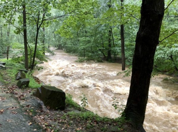
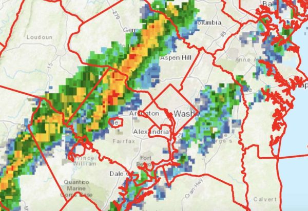
(Updated at 1:35 p.m.) After getting drenched by a storm early this morning, Arlington may be getting another round of heavy rain tonight.

The county and the D.C. region is currently under a Flash Flood Watch. Slow-moving storms are expected to form this afternoon, dumping torrential rainfall on ground already saturated by the morning storm and Isaias earlier this week — a recipe for flooding.

The watch is now in effect until 6 a.m. Friday; it was originally set to expire at midnight but was extended Thursday afternoon.

More from the National Weather Service:

…FLASH FLOOD WATCH IN EFFECT THROUGH THIS EVENING…

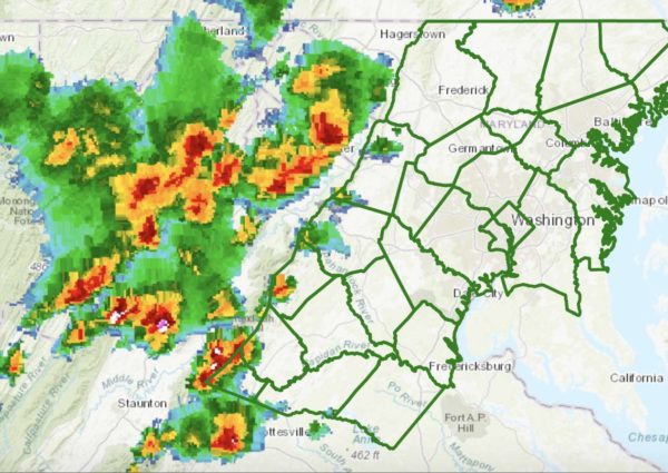
Through this evening… Numerous slow moving showers and thunderstorms continue to develop across the region and should expand and redevelop with time. Locations which are repetitively affected could receive multiple-inch rainfall totals. This could lead to rapid rises on streams and flash flooding of low lying areas.

PRECAUTIONARY/PREPAREDNESS ACTIONS… A Flash Flood Watch means that conditions may develop that lead to flash flooding. Flash flooding is a very dangerous situation. You should monitor later forecasts and be prepared to take action should Flash Flood Warnings be issued.

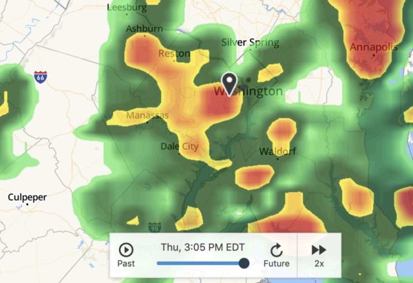
Image via The Weather Channel

Low Water Pressure in RosslynUpdated at 9 a.m. — “LOW WATER PRESSURE: Customers in the Rosslyn area may be experiencing low water pressure due to a water main break on Key Blvd b/w N Edgewood St and N Danville St. Crews have been dispatched. Expected completion time: TBD. An update will be provided once we have more information.” [Twitter]

Changes to Crystal City Development — “JBG Smith Properties is shrinking plans for a pair of residential towers at 2000 and 2001 South Bell Street in Crystal City in a bid to get them approved after Arlington County planners raised concerns about its height. The developer filed revised plans for the Amazon-adjacent development earlier in July, lopping off several stories of each proposed tower to appease Arlington officials.” [Washington Business Journal]

New Sheriff’s Office Employee — “On July 20, 2020, the Arlington County Sheriff’s Office welcomed Diana Fetterer to the Pretrial Section, where she will begin her new role as a member of the newly established Behavioral Health Docket Team… The Behavioral Health Docket is scheduled to start in September 2020.” [Arlington County]

Flash Flood Watch Today — “Showers with scattered thunderstorms are expected overnight through Friday. Locally heavy rainfall may produce flooding. A Flash Flood Watch is now in effect for much of the region.” [Twitter]


Storms today may cause flash flooding, forecasters say.

The National Weather Service has issued a Flash Flood Watch for Arlington and the immediate D.C. metro area, saying that torrential downpours could dump 2-3 inches of rain in under an hour.

The watch will go into effect at 3 p.m.

More from NWS:

THE NATIONAL WEATHER SERVICE IN STERLING VIRGINIA HAS ISSUED A

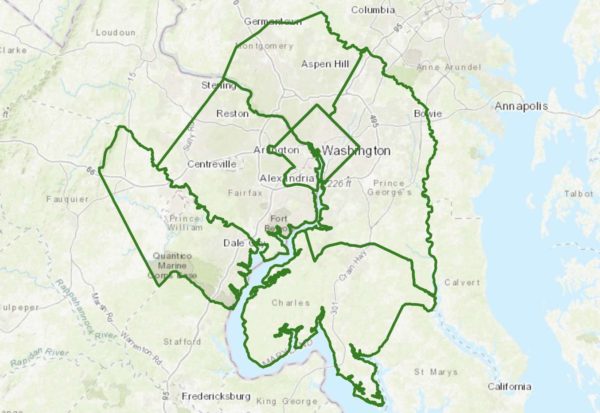
* FLASH FLOOD WATCH FOR PORTIONS OF MARYLAND, THE DISTRICT OF COLUMBIA, AND NORTHERN VIRGINIA, INCLUDING THE FOLLOWING AREAS, IN MARYLAND, CENTRAL AND SOUTHEAST MONTGOMERY, CHARLES, AND PRINCE GEORGES. THE DISTRICT OF COLUMBIA. IN NORTHERN VIRGINIA, ARLINGTON/FALLS CHURCH/ALEXANDRIA, FAIRFAX, AND  PRINCE WILLIAM.

* FROM 3 PM THIS AFTERNOON UNTIL 11 PM EDT THIS EVENING.

* A SLOW-MOVING COLD FRONT WILL INTERSECT A HOT AND HUMID AIR MASS RESULTING IN SCATTERED TO NUMEROUS SHOWERS AND THUNDERSTORMS LATE THIS AFTERNOON AND EVENING. MULTIPLE ROUNDS OF THUNDERSTORMS ARE POSSIBLE, WHICH COULD RESULT IN ISOLATED RAINFALL AMOUNTS OF 2 TO 3 INCHES IN A SHORT AMOUNT OF TIME. THESE RAINFALL AMOUNTS MAY RESULT IN RAPID RISES OF WATER ON  SMALL STREAMS AND CREEKS, AS WELL AS IN URBAN AND POOR DRAINAGE AREAS.

PRECAUTIONARY/PREPAREDNESS ACTIONS…

A FLASH FLOOD WATCH MEANS THAT CONDITIONS MAY DEVELOP THAT LEAD TO FLASH FLOODING. FLASH FLOODING IS A VERY DANGEROUS SITUATION.

YOU SHOULD MONITOR LATER FORECASTS AND BE PREPARED TO TAKE ACTION SHOULD FLASH FLOOD WARNINGS BE ISSUED.

In addition to the threat of heavy rain, some storms may be severe, with gusty winds and frequent lightning.


Update at 3:35 p.m. — A Severe Thunderstorm Warning and Flash Flood Warning have been issued.

In addition to a Heat Advisory and a Severe Thunderstorm Watch, Arlington, D.C. and surrounding area are also now under a Flash Flood Watch.

The watch is in effect until 11 p.m. The National Weather Service says storms packing torrential rains may cause localized flooding.

More from NWS:

136 PM EDT WED JUL 22 2020

…FLASH FLOOD WATCH IN EFFECT UNTIL 11 PM EDT THIS EVENING…

THE NATIONAL WEATHER SERVICE IN STERLING VIRGINIA HAS ISSUED A

* FLASH FLOOD WATCH…

* UNTIL 11 PM EDT THIS EVENING

* THUNDERSTORMS WITH LOCALLY HEAVY RAIN ARE EXPECTED ACROSS THE WATCH AREA THIS AFTERNOON AND EVENING. RAINFALL OF 1 TO 3 INCHES MAY FALL WITHIN AN HOUR, RESULTING IN LOCALIZED FLASH FLOODING.

PRECAUTIONARY/PREPAREDNESS ACTIONS…

A FLASH FLOOD WATCH MEANS THAT CONDITIONS MAY DEVELOP THAT LEAD TO FLASH FLOODING. FLASH FLOODING IS A VERY DANGEROUS SITUATION.

YOU SHOULD MONITOR LATER FORECASTS AND BE PREPARED TO TAKE ACTION SHOULD FLASH FLOOD WARNINGS BE ISSUED.


Update at 3:35 p.m. — A Severe Thunderstorm Warning and Flash Flood Warning have been issued.

Arlington and surrounding areas are under a Heat Advisory from 11 a.m.-8 p.m., while forecasters caution about the possibility of strong storms later today.

The National Weather Service says damaging winds and flooding rains may cause for a wild weather evening. Around noon today, a Severe Thunderstorm Watch was issued for Arlington and the region through 7 p.m.

SCATTERED THUNDERSTORMS THIS AFTERNOON AND EVENING COULD PRODUCE ISOLATED DAMAGING WIND GUSTS, AS WELL AS HEAVY RAINFALL, WHICH COULD LEAD TO ISOLATED INSTANCES OF FLASH FLOODING.

Ahead of the storms, a combination of hot temperatures and high humidity could make for dangerous conditions for anyone exerting themselves outdoors. More from NWS:

751 AM EDT WED JUL 22 2020

…HEAT ADVISORY NOW IN EFFECT FROM 11 AM THIS MORNING TO 8 PM EDT THIS EVENING…

* WHAT…HEAT INDEX VALUES UP TO 109 EXPECTED.

* WHERE…THE DISTRICT OF COLUMBIA, CENTRAL, NORTHERN AND SOUTHERN MARYLAND AND CENTRAL AND NORTHERN VIRGINIA.

* WHEN…FROM 11 AM THIS MORNING TO 8 PM EDT THIS EVENING.

* IMPACTS…HOT TEMPERATURES AND HIGH HUMIDITY MAY CAUSE HEAT ILLNESSES TO OCCUR.

PRECAUTIONARY/PREPAREDNESS ACTIONS…

DRINK PLENTY OF FLUIDS, STAY IN AN AIR-CONDITIONED ROOM, STAY OUT OF THE SUN, AND CHECK UP ON RELATIVES AND NEIGHBORS. YOUNG CHILDREN AND PETS SHOULD NEVER BE LEFT UNATTENDED IN VEHICLES UNDER ANY CIRCUMSTANCES.

TAKE EXTRA PRECAUTIONS IF YOU WORK OR SPEND TIME OUTSIDE. WHEN POSSIBLE RESCHEDULE STRENUOUS ACTIVITIES TO EARLY MORNING OR EVENING. KNOW THE SIGNS AND SYMPTOMS OF HEAT EXHAUSTION AND HEAT STROKE. WEAR LIGHTWEIGHT AND LOOSE FITTING CLOTHING WHEN POSSIBLE. TO REDUCE RISK DURING OUTDOOR WORK, THE OCCUPATIONAL SAFETY AND HEALTH ADMINISTRATION RECOMMENDS SCHEDULING FREQUENT REST BREAKS IN SHADED OR AIR CONDITIONED ENVIRONMENTS. ANYONE OVERCOME BY HEAT SHOULD BE MOVED TO A COOL AND SHADED LOCATION. HEAT STROKE IS AN EMERGENCY! CALL 9 1 1.

CDC RECOMMENDS THAT IF YOU NEED TO GO TO A COOLING CENTER, WEAR A CLOTH FACE COVERING. WHILE YOU ARE THERE, WASH YOUR HANDS WITH SOAP, OR USE HAND SANITIZER, OFTEN. FACE COVERS SHOULD NOT BE USED BY CHILDREN UNDER THE AGE OF 2. THEY ALSO SHOULD NOT BE USED BY PEOPLE HAVING TROUBLE BREATHING, OR WHO ARE UNCONSCIOUS, INJURED, OR CAN’T REMOVE THE MASK THEMSELVES.


Another round of severe storms packing torrential rainfall and strong winds is possible today.

The National Weather Service has issued both flash flood and severe thunderstorm watches for Arlington and parts of the D.C. region.

The Flash Flood Watch is in effect until 9 p.m., while the Severe Thunderstorm Watch is in effect until 11 p.m.

“Severe thunderstorms are possible this afternoon and evening with locally damaging winds and large hail being the primary threat,” the National Weather Service says. “There is also an isolated threat for flooding.”

More from NWS:

THE FLASH FLOOD WATCH CONTINUES FOR

* PORTIONS OF MARYLAND, THE DISTRICT OF COLUMBIA, AND NORTHERN VIRGINIA, INCLUDING THE FOLLOWING AREAS, IN MARYLAND, ANNE ARUNDEL, CENTRAL AND SOUTHEAST HOWARD, CENTRAL AND SOUTHEAST MONTGOMERY, NORTHERN BALTIMORE, NORTHWEST HARFORD, PRINCE GEORGES, SOUTHEAST HARFORD, AND SOUTHERN BALTIMORE. THE DISTRICT OF COLUMBIA. IN NORTHERN VIRGINIA, ARLINGTON/FALLS CHURCH/ALEXANDRIA.

* UNTIL 9 PM EDT THIS EVENING

* THUNDERSTORMS WILL DEVELOP THIS AFTERNOON AND CONTINUE THIS EVENING ALONG THE I-95 CORRIDOR. SOME AREAS MAY EXPERIENCE MULTIPLE THUNDERSTORMS THROUGH THIS EVENING. RAINFALL AMOUNTS  OF 1-2 INCHES ARE POSSIBLE, WITH SOME ISOLATED AMOUNTS OVER 3  INCHES POSSIBLE. THIS AMOUNT OF RAIN OVER URBAN AREAS MAY LEAD TO INSTANCES OF FLASH FLOODING, AS WELL AS A POTENTIAL FOR CREEKS AND STREAMS TO RISE RAPIDLY IF SOME OF THE HIGHER AMOUNTS ARE REALIZED.

PRECAUTIONARY/PREPAREDNESS ACTIONS…

A FLASH FLOOD WATCH MEANS THAT CONDITIONS MAY DEVELOP THAT LEAD TO FLASH FLOODING. FLASH FLOODING IS A VERY DANGEROUS SITUATION.

YOU SHOULD MONITOR LATER FORECASTS AND BE PREPARED TO TAKE ACTION SHOULD FLASH FLOOD WARNINGS BE ISSUED.


More heavy rain and storms are expected tonight (Friday).

A Flash Flood Watch is in effect until midnight, as slow-moving storms and an additional 1-3 inches of rain could send creeks and streams over their banks. The storms are currently expected to arrive in the Arlington area around 6 p.m.

More from the National Weather Service:

…FLASH FLOOD WATCH REMAINS IN EFFECT UNTIL MIDNIGHT EDT TONIGHT… AREAS OF HEAVY RAIN FELL ACROSS THE WATCH AREA LAST NIGHT. ADDITIONAL HEAVY RAINFALL IS EXPECTED THIS AFTERNOON AS SLOW MOVING THUNDERSTORMS DEVELOP BY MIDDAY AND SLIDE EAST DURING THE AFTERNOON AND EVENING. SOME AREAS COULD RECEIVE AN ADDITIONAL 1 TO 3 INCHES OF RAIN, WHICH COULD RESULT IN FLASH FLOODING. PRECAUTIONARY/PREPAREDNESS ACTIONS… A FLASH FLOOD WATCH MEANS THAT CONDITIONS MAY DEVELOP THAT LEAD TO FLASH FLOODING. FLASH FLOODING IS A VERY DANGEROUS SITUATION. YOU SHOULD MONITOR LATER FORECASTS AND BE PREPARED TO TAKE ACTION SHOULD FLASH FLOOD WARNINGS BE ISSUED. &&


Updated at 11:10 p.m. — A Flash Flood Watch has been issued for Arlington and much of the region.

THE NATIONAL WEATHER SERVICE IN STERLING VIRGINIA HAS ISSUED A

* FLASH FLOOD WATCH…

* UNTIL 4 AM EDT FRIDAY

* REPEATING ROUNDS OF SHOWERS AND THUNDERSTORMS MAY PRODUCE LOCALIZED RAINFALL AMOUNTS OF 1 TO 3 INCHES IN A RELATIVELY SHORT AMOUNT OF TIME. THIS MAY CAUSE RAPID RISES OF WATER ON STREAMS AND CREEKS AND IN URBAN AND POOR DRAINAGE AREAS.

PRECAUTIONARY/PREPAREDNESS ACTIONS…

A FLASH FLOOD WATCH MEANS THAT CONDITIONS MAY DEVELOP THAT LEAD TO FLASH FLOODING. FLASH FLOODING IS A VERY DANGEROUS SITUATION.

YOU SHOULD MONITOR LATER FORECASTS AND BE PREPARED TO TAKE ACTION SHOULD FLASH FLOOD WARNINGS BE ISSUED.

Update at 8:05 p.m. — The storm warning has been extended until 8:45 p.m. From the National Weather Service:

BULLETIN – IMMEDIATE BROADCAST REQUESTED
SEVERE THUNDERSTORM WARNING
NATIONAL WEATHER SERVICE BALTIMORE MD/WASHINGTON DC
801 PM EDT THU JUN 4 2020

THE NATIONAL WEATHER SERVICE IN STERLING VIRGINIA HAS ISSUED A

* SEVERE THUNDERSTORM WARNING…

* UNTIL 845 PM EDT.

* AT 800 PM EDT, SEVERE THUNDERSTORMS WERE LOCATED ALONG A LINE EXTENDING FROM ADAMS MORGAN TO HUNTINGTON TO NEAR WOODBRIDGE, MOVING EAST AT 20 MPH.

HAZARD…60 MPH WIND GUSTS.

SOURCE…RADAR INDICATED.

IMPACT…DAMAGING WINDS WILL CAUSE SOME TREES AND LARGE BRANCHES TO FALL. THIS COULD INJURE THOSE OUTDOORS, AS WELL AS  DAMAGE HOMES AND VEHICLES. ROADWAYS MAY BECOME BLOCKED BY DOWNED TREES. LOCALIZED POWER OUTAGES ARE POSSIBLE.  UNSECURED LIGHT OBJECTS MAY BECOME PROJECTILES.

* LOCATIONS IMPACTED INCLUDE… ARLINGTON, ALEXANDRIA, WALDORF, BOWIE, CLINTON, FORT WASHINGTON, FORT HUNT, GROVETON, FORESTVILLE, HUNTINGTON, LARGO, CORAL HILLS, BLADENSBURG, LA PLATA, FORT BELVOIR, NATIONAL HARBOR, UPPER MARLBORO, NATIONALS PARK, FEDEX FIELD AND HOWARD UNIVERSITY.

PRECAUTIONARY/PREPAREDNESS ACTIONS…

FOR YOUR PROTECTION MOVE TO AN INTERIOR ROOM ON THE LOWEST FLOOR OF A BUILDING.

DAMAGING WIND AND CONTINUOUS CLOUD TO GROUND LIGHTNING IS OCCURRING  WITH THESE STORMS. MOVE INDOORS IMMEDIATELY. LIGHTNING IS ONE OF NATURE’S LEADING KILLERS. REMEMBER, IF YOU CAN HEAR THUNDER, YOU ARE CLOSE ENOUGH TO BE STRUCK BY LIGHTNING.

Update at 7:55 p.m. — A Severe Thunderstorm Warning has been issued for Arlington through 8:15 p.m.

(more…)


The National Weather Service has issued a Flood Watch for most of the day on Thursday.

Forecasters say heavy rain could cause flooding, particularly around streams and low-lying areas. The heaviest rain is expected in the afternoon and evening.

More from NWS:

FLOOD WATCH IN EFFECT FROM THURSDAY AFTERNOON THROUGH THURSDAY EVENING… WIDESPREAD HEAVY RAINFALL IS EXPECTED THURSDAY AFTERNOON INTO THURSDAY EVENING ALONG AND AHEAD OF A STRONG COLD FRONT. WIDESPREAD RAINFALL TOTALS OF ONE AND HALF TO TWO AND HALF INCHES ARE EXPECTED WITH THE POTENTIAL FOR UP TO FOUR INCHES. * THIS AMOUNT OF RAINFALL WILL LIKELY RESULT IN SMALL STREAM AND MAIN STEM RIVER FLOODING. MODERATE RIVER FLOODING IS ALSO POSSIBLE. PRECAUTIONARY/PREPAREDNESS ACTIONS… A FLOOD WATCH MEANS THERE IS A POTENTIAL FOR FLOODING BASED ON CURRENT FORECASTS. YOU SHOULD MONITOR LATER FORECASTS AND BE ALERT FOR POSSIBLE FLOOD WARNINGS. THOSE LIVING IN AREAS PRONE TO FLOODING SHOULD BE PREPARED TO TAKE ACTION SHOULD FLOODING DEVELOP. &&

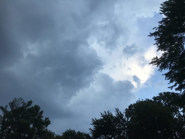
Photo courtesy Brandon Jones


Arlington and most of the metropolitan D.C. area are now under a Tornado Watch.

While a Wind Advisory remains in effect until 6 p.m., the National Weather Service has added a Tornado Watch on top of it, also through 6 p.m.

Winds are expected to start whipping up this afternoon, and some tornados may spawn as a storm system makes its way through the Mid-Atlantic and up the East Coast.


Update at 4:50 p.m. — The Flood Watch has been cancelled. 

Earlier: Arlington County and surrounding areas are under a Flood Watch starting this afternoon.

The National Weather Service says 1-3 inches of rain are possible between now and Friday morning. The rain may be heavy at times and might cause flooding, according to forecasters.

More from NWS:

FLOOD WATCH REMAINS IN EFFECT FROM 1 PM EST THIS AFTERNOON THROUGH FRIDAY MORNING… THE FLOOD WATCH CONTINUES FOR * PORTIONS OF MARYLAND, THE DISTRICT OF COLUMBIA, AND VIRGINIA… FROM 1 PM EST THIS AFTERNOON THROUGH FRIDAY MORNING * MULTIPLE ROUNDS OF RAINFALL WILL OCCUR THROUGH EARLY FRIDAY. THE HEAVIEST RAINFALL POTENTIAL WILL BEGIN THIS AFTERNOON AND CONTINUE INTO THIS EVENING. STORM TOTAL RAINFALL AMOUNTS THROUGH FRIDAY MORNING ARE EXPECTED TO RANGE BETWEEN 1 AND 2 INCHES WITH ISOLATED AMOUNTS NEAR 3 INCHES POSSIBLE. * FLOODING OF POOR DRAINAGE AND LOW LYING AREAS WILL BE POSSIBLE, AND SOME SMALLER STREAMS AND RIVERS MAY EXCEED THEIR BANKS. PRECAUTIONARY/PREPAREDNESS ACTIONS… A FLOOD WATCH MEANS THERE IS A POTENTIAL FOR FLOODING BASED ON CURRENT FORECASTS. YOU SHOULD MONITOR LATER FORECASTS AND BE ALERT FOR POSSIBLE FLOOD WARNINGS. THOSE LIVING IN AREAS PRONE TO FLOODING SHOULD BE PREPARED TO TAKE ACTION SHOULD FLOODING DEVELOP. &&

Nearby, the City of Falls Church is distributing free sandbags to residents ahead of the possible flooding.

Flickr pool photo by Erinn Shirley


View More Stories