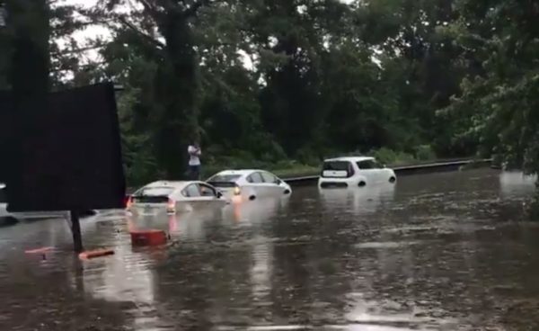
A Tornado Watch has been issued for Arlington and the D.C. region as severe storms threaten dangerous conditions amid tonight’s Halloween festivities.

The Tornado Watch is in effect until midnight.

Forecasters warn that a line of storms packing rain and gusty winds will reach Arlington around 9 p.m. Trick-or-treaters and Halloween partiers should seek shelter ahead of the storms.

The National Weather Service issued a special statement about the storm threat:

…DAMAGING LINE OF THUNDERSTORMS LIKELY TO MOVE EAST ACROSS THE AREA BETWEEN MID AFTERNOON AND MIDNIGHT…

A LINE OF THUNDERSTORMS IS EXPECTED TO MOVE EAST ACROSS THE REGION. THESE STORMS WILL BRING THE POSSIBILITY OF DAMAGING WIND  GUSTS AND ISOLATED TORNADOES. PLEASE BE SHELTERED WHEN THESE  THUNDERSTORMS PASS THROUGH YOUR AREA.

THE MOST LIKELY TIMING OF THE LINE RANGES FROM MID TO LATE AFTERNOON FOR THE POTOMAC HIGHLANDS, TO THE EVENING FOR THE BALTIMORE/WASHINGTON METROS, TO BETWEEN 9PM AND MIDNIGHT FOR AREAS EAST OF I-95 TO THE CHESAPEAKE BAY. THE STORMS WILL LIKELY LAST AN HOUR OR LESS IN MOST AREAS.

STAY INFORMED. FOR MORE EXACT TIMING FOR YOUR LOCATION, CONSULT THE FORECAST FOR YOUR COMMUNITY AT OUR WEBSITE WEATHER.GOV OR OUR FACEBOOK OR TWITTER FEEDS FOR NATIONAL WEATHER SERVICE BALTIMORE/WASHINGTON.

More via social media:


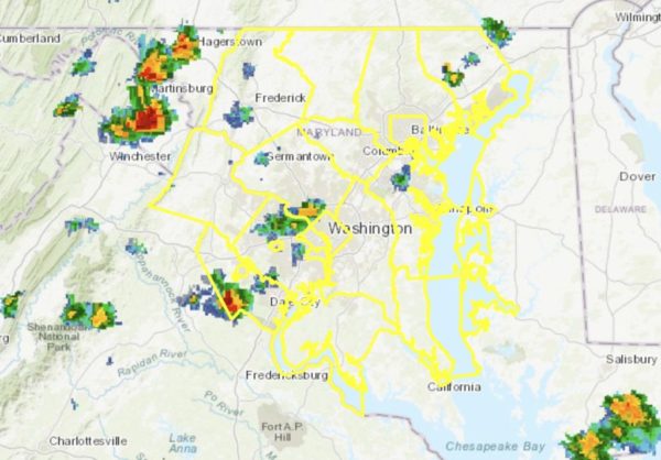
Arlington and much of the D.C. and Baltimore metro area is under a Severe Thunderstorm Watch until 10 p.m. tonight.

Though the storms are not expected to pack the punch of last night’s severe weather, damaging winds and hail are still possible.

Image via National Weather Service


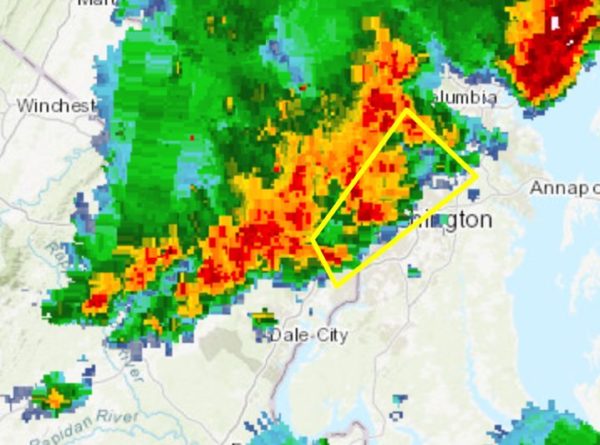
Update at 4:40 p.m. — A portion of northern and eastern Arlington County is now under a Severe Thunderstorm Warning until 5:15 p.m.

Earlier: Arlington, D.C. and much of the region are under a Severe Thunderstorm Watch this evening.

Forecasters say strong storms packing damaging wind gusts and hail are possible. The storms may also cause areas of flooding.

More from the National Weather Service:

A SEVERE THUNDERSTORM WATCH IS IN EFFECT FOR THE OUTLOOK AREA UNTIL 9 PM THIS EVENING. THUNDERSTORMS MAY PRODUCE LOCALIZED DAMAGING WIND GUSTS AND ISOLATED INSTANCES OF FLOODING THIS AFTERNOON AND EVENING.

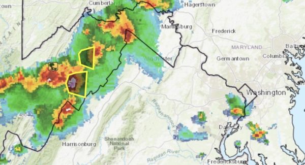
Weather radar shows a line of storms to the west, currently near the Virginia/West Virginia border.

Those driving tonight are being encouraged by VDOT to “stay weather aware.”

https://twitter.com/VaDOT/status/1163901482867089408

Flickr pool photo by Kevin Wolf


Update at 3:55 p.m. — A Severe Thunderstorm Warning has been issued for Arlington.

From the National Weather Service:

BULLETIN – IMMEDIATE BROADCAST REQUESTED
SEVERE THUNDERSTORM WARNING
NATIONAL WEATHER SERVICE BALTIMORE MD/WASHINGTON DC
352 PM EDT WED AUG 7 2019

THE NATIONAL WEATHER SERVICE IN STERLING VIRGINIA HAS ISSUED A

* SEVERE THUNDERSTORM WARNING…

* UNTIL 430 PM EDT.

* AT 352 PM EDT, A SEVERE THUNDERSTORM WAS LOCATED OVER ARLINGTON, MOVING NORTHEAST AT 30 MPH.

HAZARD…60 MPH WIND GUSTS AND QUARTER SIZE HAIL.

SOURCE…RADAR INDICATED.

IMPACT…DAMAGING WINDS WILL CAUSE SOME TREES AND LARGE BRANCHES TO FALL. THIS COULD INJURE THOSE OUTDOORS, AS WELL AS DAMAGE HOMES AND VEHICLES. ROADWAYS MAY BECOME BLOCKED BY DOWNED TREES. LOCALIZED POWER OUTAGES ARE POSSIBLE. UNSECURED LIGHT OBJECTS MAY BECOME PROJECTILES.

* LOCATIONS IMPACTED INCLUDE… ARLINGTON, ALEXANDRIA, COLUMBIA, BETHESDA, BOWIE, ANNANDALE, COLLEGE PARK, CROFTON, GREENBELT, LANGLEY PARK, BELTSVILLE, GROVETON, FALLS CHURCH, HUNTINGTON, CORAL HILLS, BLADENSBURG, FEDEX FIELD, FORT TOTTEN, ROSSLYN AND CRYSTAL CITY.

PRECAUTIONARY/PREPAREDNESS ACTIONS…

FOR YOUR PROTECTION MOVE TO AN INTERIOR ROOM ON THE LOWEST FLOOR OF A BUILDING.

Earlier: Arlington County is under a Severe Thunderstorm Watch until 8 p.m. tonight.

The watch was issued shortly before 2 p.m. Wednesday, as a line of strong storms formed west and north of the area. Forecasters say hail, high winds and frequent lightning are possible with today’s storms.

“Seek shelter from damaging winds and flash flooding if warnings are issued,” Virginia’s Dept. of Emergency Management said in a tweet today.

More from social media:

https://twitter.com/VaDOT/status/1159165932884910081

File photo


Update at 6:20 p.m. — The watches have been canceled.

Update at 1:25 p.m. — A Severe Thunderstorm Watch has also been issued for Arlington, from 1:15-9 p.m.

Earlier: Heavy rain and storms could lead to flash flooding today, forecasters say.

The National Weather Service has issued a Flash Flood Watch for Arlington, D.C., and a portion of the I-95 corridor. The watch is in effect from 2-8 p.m. today.

…FLASH FLOOD WATCH IN EFFECT UNTIL 8 PM EDT THIS EVENING… THE NATIONAL WEATHER SERVICE IN STERLING VIRGINIA HAS ISSUED A * FLASH FLOOD WATCH FOR PORTIONS OF MARYLAND, THE DISTRICT OF COLUMBIA, AND NORTHERN VIRGINIA, INCLUDING THE FOLLOWING AREAS, IN MARYLAND, ANNE ARUNDEL, CENTRAL AND SOUTHEAST HOWARD, CENTRAL AND SOUTHEAST MONTGOMERY, BALTIMORE, HARFORD, AND PRINCE GEORGES COUNTIES. THE DISTRICT OF COLUMBIA. IN NORTHERN VIRGINIA, ARLINGTON/FALLS CHURCH/ALEXANDRIA AND FAIRFAX. * UNTIL 8 PM EDT THIS EVENING * SHOWERS AND THUNDERSTORMS CAPABLE OF PRODUCING VERY HEAVY RAINFALL ARE EXPECTED ACROSS THE AREA THIS AFTERNOON AND INTO THE EVENING. THIS HEAVY RAIN MAY LEAD TO LOCALIZED TOTAL RAINFALL AMOUNTS OF UP TO 3 INCHES. MUCH OF THIS RAIN MAY FALL IN SHORT PERIODS OF TIME IN ANY GIVEN LOCATION, RESULTING IN THE RISK FOR FLASH FLOODING. PRECAUTIONARY/PREPAREDNESS ACTIONS… A FLASH FLOOD WATCH MEANS THAT CONDITIONS MAY DEVELOP THAT LEAD TO FLASH FLOODING. FLASH FLOODING IS A VERY DANGEROUS SITUATION. YOU SHOULD MONITOR LATER FORECASTS AND BE PREPARED TO TAKE ACTION SHOULD FLASH FLOOD WARNINGS BE ISSUED. &&

Forecasters are also monitoring for the possibility of severe storms this afternoon.

NWS issued a Hazardous Weather Outlook for the area, the precursor for a possible severe thunderstorm watch or warning.

THUNDERSTORMS MAY PRODUCE SCATTERED INCIDENTS OF DAMAGING WIND GUSTS THIS AFTERNOON AND EVENING, AS WELL AS HEAVY RAINFALL WHICH MAY RESULT IN ISOLATED INSTANCES OF FLOODING. THE HIGHEST RISK IS ALONG THE I-95 CORRIDOR WHERE A FLASH FLOOD WATCH IS IN EFFECT.


Update at 10:40 p.m. — There are still 664 Dominion customers without power across various parts of Arlington, according to the power company.

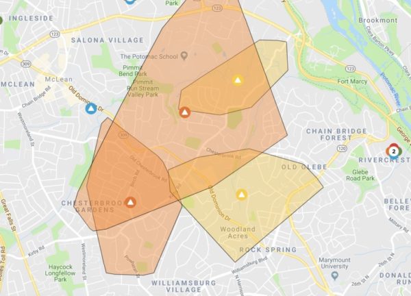
Update at 6:05 p.m. — About 700 Dominion customers are reported to be without power in Arlington, mostly in residential north Arlington, following the storms. Nearly 35,000 are reported to be without power in Fairfax County, including in the McLean area.

Update at 5:30 p.m. — A Severe Thunderstorm Watch has been issued for Arlington. More from the National Weather Service:

THE NATIONAL WEATHER SERVICE IN STERLING VIRGINIA HAS ISSUED A * SEVERE THUNDERSTORM WARNING…  UNTIL 615 PM EDT. * AT 523 PM EDT, A SEVERE THUNDERSTORM WAS LOCATED OVER AMERICAN LEGION BRIDGE, MOVING NORTHEAST AT 40 MPH. HAZARD…60 MPH WIND GUSTS. SOURCE…RADAR INDICATED. IMPACT…DAMAGING WINDS WILL CAUSE SOME TREES AND LARGE BRANCHES TO FALL. THIS COULD INJURE THOSE OUTDOORS, AS WELL AS DAMAGE HOMES AND VEHICLES. ROADWAYS MAY BECOME BLOCKED BY DOWNED TREES. LOCALIZED POWER OUTAGES ARE POSSIBLE. UNSECURED LIGHT OBJECTS MAY BECOME PROJECTILES. * LOCATIONS IMPACTED INCLUDE… ARLINGTON, COLUMBIA, ROCKVILLE, BETHESDA, GAITHERSBURG, BOWIE, SEVERN, ANNANDALE, OLNEY, COLLEGE PARK, CROFTON, GREENBELT, LANGLEY PARK, BELTSVILLE, VIENNA, ELKRIDGE, FALLS CHURCH, BLADENSBURG, PIMMIT HILLS AND MCLEAN. PRECAUTIONARY/PREPAREDNESS ACTIONS… FOR YOUR PROTECTION MOVE TO AN INTERIOR ROOM ON THE LOWEST FLOOR OF A BUILDING. && HAIL…<.75IN WIND…60MPH

Earlier: Arlington County and much of the surrounding region is now under a Severe Thunderstorm Watch.

A line of strong storms is approaching from the west, packing high winds and potentially penny-sized hail.

The storms are expected to pass through Arlington within an hour or so.


(Updated at 1:45 p.m.) As Arlington continues to recover from Monday’s flash flooding, another Flash Flood Watch has been issued.

The National Weather Service says more heavy rain and flooding is possible today, in addition to storms and damaging winds. The watch takes effect starting at 2 p.m.

After numerous water rescues on Monday, forecasters are also reminding people to “turn around, don’t drown” when encountering water of unknown depth on the roads.

More from NWS:

…FLASH FLOOD WATCH IN EFFECT FROM 2 PM EDT THIS AFTERNOON THROUGH LATE TONIGHT… SHOWERS AND THUNDERSTORMS ARE EXPECTED THIS AFTERNOON AND EVENING. TORRENTIAL RAINFALL MAY LEAD TO TOTALS EXCEEDING 2 INCHES IN A SHORT PERIOD OF TIME. THIS MAY CAUSE FLASH FLOODING OF SMALL STREAMS AND OTHER POOR DRAINAGE URBAN AREAS. PRECAUTIONARY/PREPAREDNESS ACTIONS… A FLASH FLOOD WATCH MEANS THAT CONDITIONS MAY DEVELOP THAT LEAD TO FLASH FLOODING. FLASH FLOODING IS A VERY DANGEROUS SITUATION. YOU SHOULD MONITOR LATER FORECASTS AND BE PREPARED TO TAKE ACTION SHOULD FLASH FLOOD WARNINGS BE ISSUED. &&


It’s shaping up to be a wet Sunday night.

Arlington County and surrounding areas are under a Flash Flood Watch starting at 6 p.m. Slow-moving rainstorms are expected to drop copious amounts of precipitation on much of the region, particularly to the west of D.C.

The expected downpours follow the strong storms that ripped through Arlington yesterday, dumping torrential rain on much of the county and saturating the ground. That combination could result in flooding.

More from the National Weather Service:

…FLASH FLOOD WATCH IN EFFECT FROM 6 PM EDT THIS EVENING THROUGH LATE TONIGHT… SLOW MOVING SHOWERS AND THUNDERSTORMS ARE EXPECTED TONIGHT. TORRENTIAL RAINFALL MAY LEAD TO TOTALS EXCEEDING 2 INCHES IN A SHORT PERIOD OF TIME. THIS MAY CAUSE FLASH FLOODING OF SMALL STREAMS AND OTHER POOR DRAINAGE URBAN AREAS. PRECAUTIONARY/PREPAREDNESS ACTIONS… A FLASH FLOOD WATCH MEANS THAT CONDITIONS MAY DEVELOP THAT LEAD TO FLASH FLOODING. FLASH FLOODING IS A VERY DANGEROUS SITUATION. YOU SHOULD MONITOR LATER FORECASTS AND BE PREPARED TO TAKE ACTION SHOULD FLASH FLOOD WARNINGS BE ISSUED. &&

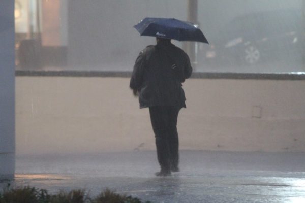
File photo


Arlington is again under a Severe Thunderstorm Watch tonight.

The watch, which goes until 10 p.m., is in addition to a separate Flash Flood Watch through 11 p.m.

Forecasters say severe storms with hail and high winds are possible today in parts of the D.C. area, including Arlington.


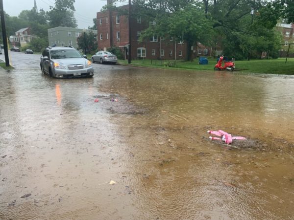
Columbia Pike Flooding — Columbia Pike flooded near S. Greenbrier Street during last night’s storms. Drivers could be seen driving through standing water as high as the tops of car tires. [Twitter]

Another Flash Flood Watch — Arlington is again under a Flash Flood Watch from 2-11 p.m. today, as slow-moving storms may produce torrential, flooding rainfalls. [Weather.gov, Twitter]

County to Tackle Premature Tree Deaths — “‘The county is not taking adequate care of its newly planted trees,’ said [Elizabeth] Grossman, a member of the Arlington Tree Action Group, who said that while there were many reasons trees may not survive after being planted, the death rate on Arlington government property seems excessive.” [InsideNova]

Fire at Ballston Building — “Firefighters are on scene of a fire at a high-rise residential building on the 800 block of N. Quincy Street in Ballston. Reportedly a small fire in one of the units.” [Twitter, Twitter]

One Reason Arlington Landed HQ2 — “A West Coast economist’s ideas challenge the ‘world is flat’ conventional wisdom about tech jobs. They’re a major part of the reason Arlington landed Amazon.” [Washingtonian, Twitter]

Retiring Superintendent Has a New Gig — Last week, Arlington Public Schools Superintendent Dr. Patrick K. Murphy told the School Board he would be retiring in September. On Sept. 1, he will begin his new job as superintendent of Berkeley County Schools in West Virginia. [Berkeley County Schools]


Update at 4:25 p.m. — A Severe Thunderstorm Watch has been issued for Arlington through 11 p.m.

Update at 1:15 p.m. — The Flash Flood Watch for Arlington has been cancelled, but storms are still expected later today, according to the National Weather Service.

Earlier: Arlington County and surrounding areas are under a Flash Flood Watch starting at 2 p.m. today.

Forecasters say heavy rain and storms are expected this afternoon and evening, creating the potential for flash flooding.

More from the National Weather Service:

…FLASH FLOOD WATCH IN EFFECT FROM 2 PM EDT THIS AFTERNOON THROUGH THIS EVENING… NUMEROUS TO WIDESPREAD SHOWERS AND THUNDERSTORMS ARE EXPECTED THIS AFTERNOON AND THIS EVENING IN A VERY WARM AND HUMID ENVIRONMENT. THERE IS POTENTIAL FOR SHOWERS TO MOVE REPEATEDLY OVER THE SAME AREAS AND TO PRODUCE INTENSE RAINFALL RATES IN A SHORT PERIOD OF TIME THAT MAY LEAD TO FLASH FLOODING. THE GREATEST RISK OF FLASH FLOODING IS ACROSS NORTHERN AND CENTRAL MARYLAND. PRECAUTIONARY/PREPAREDNESS ACTIONS… A FLASH FLOOD WATCH MEANS THAT CONDITIONS MAY DEVELOP THAT LEAD TO FLASH FLOODING. FLASH FLOODING IS A VERY DANGEROUS SITUATION. YOU SHOULD MONITOR LATER FORECASTS AND BE PREPARED TO TAKE ACTION SHOULD FLASH FLOOD WARNINGS BE ISSUED. &&

File photo


View More Stories