Flags blowing in the wind at Arlington County government headquarters (staff photo by Jay Westcott)
If you haven’t noticed, it’s really windy outside — and that has prompted what we believe is the first Wind Advisory of the year for Arlington.
Forecasters caution that downed tree limbs and power outages are possible. Currently, no outages are being reported in Arlington by Dominion, but the power company is reporting nearly 3,600 customers without power in neighboring Fairfax County.
From the National Weather Service:
321 PM EST Fri Feb 17 2023
…WIND ADVISORY IN EFFECT UNTIL 7 PM EST THIS EVENING…
* WHAT…Northwest winds 20 to 35 mph with gusts up to 50 mph.
* WHERE…Northern and central Maryland, the Washington and Baltimore Metropolitan areas, northern Virginia,the Blue Ridge Mountains, and the eastern Panhandle of West Virginia.
* WHEN…Until 7 PM EST this evening.
* IMPACTS…Gusty winds could blow around unsecured objects. Tree limbs could be blown down and a few power outages may result.
PRECAUTIONARY/PREPAREDNESS ACTIONS…
Use extra caution when driving, especially if operating a high profile vehicle. Secure outdoor objects.
Strong winds are expected through this evening. A Wind Advisory is in effect for portions of the area (see map) where northwest wind gusts around 45 to 50 mph are expected. pic.twitter.com/xEVNy0v031
Power outage in Arlington as of 10 a.m. (via Dominion)
Update at 3:05 p.m. — Numerous small, scattered outages have been reported around Arlington. The number of Dominion customers in the dark is now down to just over 800, with the larger earlier outage since largely resolved.
Earlier: Today’s frigid wind storm is just getting underway — complete with a recent bout of snow flurries — but many are already without power in Arlington.
As of 10 a.m., more than 1,500 Dominion customers are in the cold, according to the power company’s website.
The following outages were reported on Dominion’s map.
718 customers, in Penrose and Lyon Park
715 customers, between Ballston and Westover
114 customers, in Glebewood
At least two smaller outages in Bellevue Forest and Ashton Heights
The Penrose outage has closed Arlington’s Dept. of Human Services offices at Sequoia Plaza, the county announced this morning.
DHS is closed today. Due to a power outage at Sequoia Plaza, Dept. of Human Services offices are closed today. Client appts will be rescheduled. Sorry for the inconvenience. @ArlingtonVA
— Arlington County Department of Human Services (@ArlingtonDHS) December 23, 2022
“Dominion Energy continues to closely monitor the extremely cold, windy weather and its potential to impact our Virginia and North Carolina service territory,” the company said in a statement today. “Our crews are positioned and ready to respond to any damage or power outages that may be caused as a result of the ice storm.”
“If you experience a power outage, please make sure you report it to Dominion Energy immediately,” the company added. “Please stay at least 30 feet away from all downed wires and damaged equipment. If you need to report an emergency or a downed wire, please call us at 1-866-DOM-HELP (1-866-366-4357)… We appreciate your patience.”
An icy rail in the Shirlington area (Flickr pool photo by Erinn Shirley)
(Updated at 7:35 a.m.) Arlington will be under both a Wind Advisory and, later, a Wind Chill Advisory on Friday.
The wind is expected to whip up starting Friday morning, then temperatures will plummet throughout the day. The combination will lead to dangerous conditions for anyone outside.
To make matters worse, the strong winds — gusts of up to 50 mph are expected — may knock out power and leave some locals in the cold.
From the National Weather Service:
737 PM EST Thu Dec 22 2022
…WIND ADVISORY REMAINS IN EFFECT FROM 8 AM TO 2 PM EST FRIDAY…
* WHAT…West winds 20 to 30 mph with gusts up to 50 mph expected.
* WHERE…Portions of central, north central, northeast, northern and southern Maryland, The District of Columbia and central and northern Virginia.
* WHEN…From 8 AM to 2 PM EST Friday.
* IMPACTS…Gusty winds could blow around unsecured objects. Tree limbs could be blown down and a few power outages may result.
* ADDITIONAL DETAILS…Bitterly cold wind chills will be ongoing during the time of this high wind event. It is essential to make preparations now for extreme cold conditions with the potential for loss of power.
PRECAUTIONARY/PREPAREDNESS ACTIONS…
Use extra caution when driving, especially if operating a high profile vehicle. Secure outdoor objects.
Also from NWS:
725 PM EST Thu Dec 22 2022
…WIND CHILL ADVISORY REMAINS IN EFFECT FROM 7 PM FRIDAY TO 10 AM EST SATURDAY…
* WHAT…Very cold wind chills expected. Wind chills as low as 10 below zero.
* WHERE…Portions of central, northeast, northern and southern Maryland, The District of Columbia and central and northern Virginia.
* WHEN…From 7 PM Friday to 10 AM EST Saturday.
* IMPACTS…The cold wind chills could result in hypothermia if precautions are not taken.
* ADDITIONAL DETAILS…The highest wind speeds will be Friday into Friday evening. Affects from the extreme cold could be made worse due to power outages.
PRECAUTIONARY/PREPAREDNESS ACTIONS…
Use caution while traveling outside. Wear appropriate clothing, a hat, and gloves.
Meanwhile, icy roads are possible due to a rapid freeze of wet surfaces following the passing of an arctic front, forecasters say.
ICY ROADS POSSIBLE TODAY for District of Columbia [DC] and Anne Arundel, Calvert, Carroll, Cecil, Central and Eastern Allegany, Central and Southeast Howard, Central and Southeast Montgomery, Frederick, Northern Baltimore, Northwest… till 11:45 AM EST https://t.co/u15MZXIe2hpic.twitter.com/SHJ29bilcc
Heavy rain along the Potomac River, with Rosslyn in the background (staff photo by Jay Westcott)
The remnants of Hurricane Nicole are heading our way, meaning a soggy and stormy Veterans Day is on tap.
The rain will start falling early Friday morning. Downpours and gusty winds are expected to follow as the day goes on, before the skies clear Saturday.
Officials are encouraging local residents to get ready now, clearing leaves from storm drains and gutters.
The storm will make for some large, soggy leaf piles on the side of the road. Arlington County does not start its vacuum leaf collection process until next week.
So far, no watches or warnings have been issued for the county. Nicole is packing a threat of localized flooding and isolated tornadoes, but Arlington is outside of the zones where those threats are most likely.
With remnants of Nicole arriving for the long weekend, now's a good time to clear gutters and downspouts. And if you see leaves covering a nearby storm drain, maybe sink your claws into that too? A grateful County thanks you. https://t.co/WXgcXEaV2Jpic.twitter.com/XJyOdqSKhs
— Arlington Department of Environmental Services (@ArlingtonDES) November 10, 2022
Increasing clouds today w/ showers arriving from the south tonight. Widespread rain overnight-Fri. AM w/ a lull midday. Additional showers & isolated severe storms Fri. aft-eve. Potential Hazards: damaging winds, an isolated tornado, & localized flooding. #VAwx#MDwx#WVwx#DCwxpic.twitter.com/bOVc28gKXD
10 AM EST November 10 Key Messages for #Nicole: Tropical storm conditions, a dangerous storm surge and damaging waves, and heavy rainfall continue over a large area. See https://t.co/tW4KeGe9uJ for more details. pic.twitter.com/kqLluAYH85
Rains from Hurricane Ian approaching the D.C. area (via National Weather Service)
Rain and wind associated with Hurricane Ian are expected to ramp up tonight in the D.C. area, but the biggest local impacts might be on your weekend plans.
Already a number of Arlington events have been modified or rescheduled, including:
The Plan Langston Blvd Walking Tour this Saturday, the start of which has been relocated to inside 4500 Langston Blvd
The Paws on the Pike pet fair, now rescheduled for Saturday, Oct. 8
No land-based watches or warnings have been issued for Arlington ahead of the storm, so far, but a Gale Warning has been issued for watercraft on the Potomac. Wind gusts of up to 40 mph are expected between 8 p.m. tonight and 6 a.m. Saturday, according to the National Weather Service.
Rain from the storm system could last all weekend and drag into Tuesday, but after an extended stretch of dry weather little to no flooding is expected locally.
Still, authorities are asking Arlington residents to be prepared just in case.
(Updated at 2:05 p.m.) More than 800 Dominion customers are without power in parts of Clarendon, Lyon Village and Cherrydale.
The outage was reported around 1:30 p.m. Police are on scene along Wilson Blvd in Clarendon, helping to direct traffic that backed up as a result of stop lights going dark.
Dominion says the cause of the outage is a “circuit out.”
Rain and wind have been picking up this afternoon, ahead of potential severe weather later today. The National Weather Service has now issued both a Severe Thunderstorm Watch and a Wind Advisory for Arlington — as well as much of the region.
Severe Thunderstorm Watch bas been issued for all of our area. A couple of tornadoes possible, isolated hail, and widespread 70MPH wind gusts is expected. pic.twitter.com/qIYYKhuTUr
— Washingtonian Weather Geeks (@WashingtonianWx) March 31, 2022
Forecasters say that wind gusts up to 50 mph may bring down trees and large branches. From NWS:
141 PM EDT Thu Mar 31 2022
…WIND ADVISORY IN EFFECT UNTIL 8 PM EDT THIS EVENING…
* WHAT…South winds 15 to 25 mph with gusts up to 50 mph expected.
* WHERE…District of Columbia, and portions of central, northern and southern Maryland, central and northern Virginia and panhandle West Virginia.
* WHEN…Until 8 PM EDT this evening.
* IMPACTS…Gusty winds could blow around unsecured objects. Isolated tree damage and a few power outages may result.
PRECAUTIONARY/PREPAREDNESS ACTIONS…
Use extra caution when driving, especially if operating a high profile vehicle. Secure outdoor objects.
Peggy Fox, a spokeswoman for the power company, said this morning that residents should charge their mobile devices in anticipation of the expected windy weather.
Strong wind gusts may bring down branches & trees today! Plan for possible outages:
1. Charge devices 2. Download @DominionEnergy app. Reporting outage on app or website gets quickest response 3. Be Safe—stay away from downed lines 4. Please don’t plant trees near lines pic.twitter.com/31W65QUlvE
A kite stuck up a tree in Rosslyn (staff photo by Jay Westcott)
Another Malfunctioning Walk Signal — Just over a week after this, another reported crosswalk signal issue: “Instead of telling you when it’s safe to cross the street, the walk signs in Crystal City, VA are just repeating ‘CHANGE PASSWORD’. Something’s gone terribly wrong here.” [Twitter]
School Board Meeting Was Mostly Maskless — “For those playing the ‘how many Arlington School Board members will go mask-free at the first board meeting after requirements were lifted?’ home game, the winners were those who had put their money on four out of five. Board members David Priddy, Cristina Diaz-Torres, Reid Goldstein and chairman Barbara Kanninen were maskless at the March 10 meeting, as was Superintendent Francisco Durán. School Board member Mary Kadera kept her mask affixed.” [Sun Gazette]
Survey Work on GW Parkway — ” A $161 million ‘complete rehabilitation‘ of the northern section of the George Washington Memorial Parkway is being planned… Through Friday, March 18, there will be single-lane closures along the northern section of the George Washington Memorial Parkway for bridge surveys. Drivers should proceed with caution in these areas and consider using alternate routes, according to an NPS alert.” [WUSA 9]
Arlington Doc Helping Refugees — “An Arlington doctor is not only battling the pandemic in Northern Virginia, but he also travels across international borders to help those in need. The current refugee crisis that began with Afghans in 2021, now includes Ukrainians facing a similar fate of displacement and an uncertain future. For three years before COVID-19 spread across the globe, Dr. Ali Karim helped build wells in Nigeria, aided orphans and women in Kabul, Afghanistan and filmed a documentary about his solo journey.” [WJLA]
Days Inn Redevelopment Update — “The plans to replace the Days Inn at 2201 Arlington Boulevard with 262 multi-family units and around 3,000 square feet of retail were filed with Arlington County last week. The eight-story project will also have surface and underground parking. STUDIOS Architecture designed the building.” [Urban Turf]
Social Sports Return to Crystal City — “Sand Volleyball is BACK in National Landing starting this May with a few fun new additions – Bocce and Corn Hole!” [Twitter]
Yes, It’s Getting Windier — “Our analysis of wind data shows that the strongest gusts have become more frequent recently. Last year featured more big wind gusts than any recent year, a trend that has continued into this year. Wind advisories, issued by the National Weather Service when gusts are expected to top 45 mph, have also been on the increase since the mid-2000s.” [Capital Weather Gang]
It’s Tuesday — Mostly cloudy throughout the day. High of 66 and low of 40. Sunrise at 7:21 am and sunset at 7:17 pm. [Weather.gov]
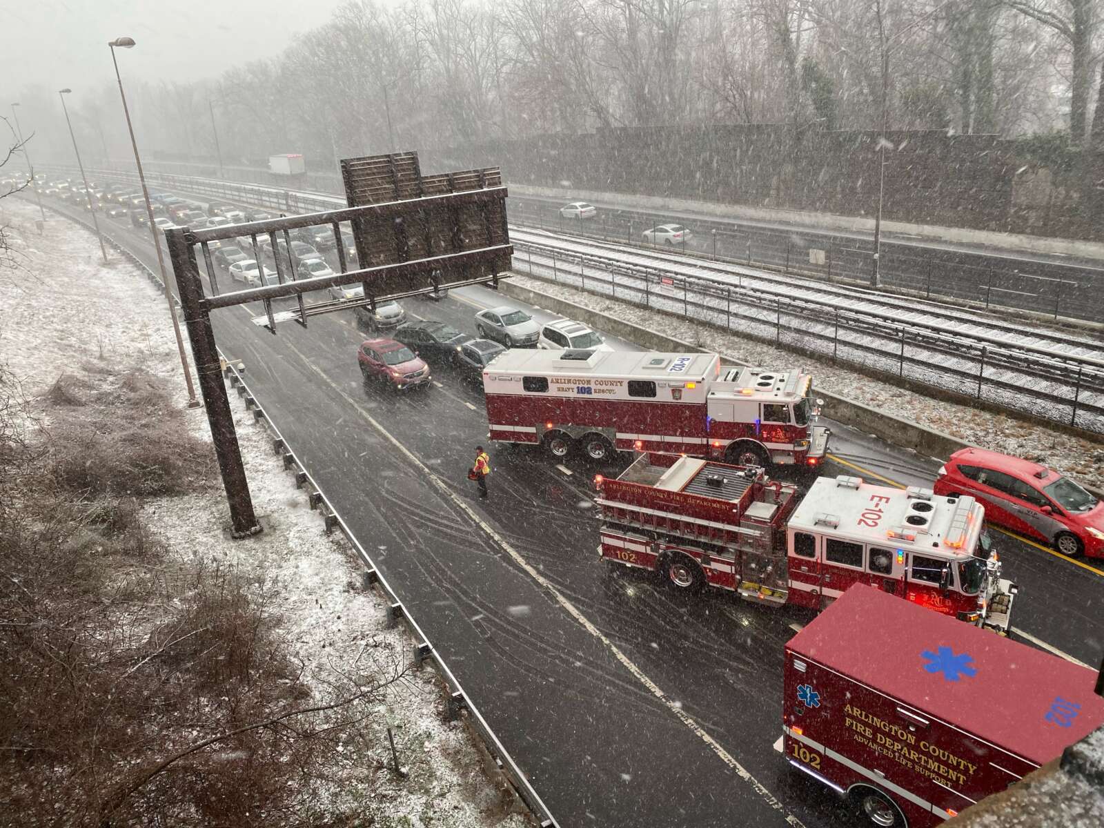
Update at 9 a.m. — Snow continues to fall amid strong winds, reducing visibility and causing slick conditions on some paved surfaces. All lanes of westbound I-66 are currently closed at Spout Run due to a crash. It’s unclear whether the crash is weather related.
LOCATION: I-66 WB/Spout Run Pkwy INCIDENT: Traffic Collision IMPACT: All lanes I-66 westbound at the Spout Run Parkway intersection are currently closed. Seek an alternate route. pic.twitter.com/8gyRcHnjEN
Earlier: Frozen precipitation is now falling on Arlington and forecasters warn that things are going to get a lot worse before they get better.
Rain is changing over to snow as temperatures fall and strong wind gusts whip up, thanks to a strong cold front and storm system making its way up the East Coast.
In addition to the earlier Winter Weather Advisory and Wind Advisory, the National Weather Service this morning issued a Special Weather Statement urging extra caution on the road if you absolutely must travel during the “near blizzard conditions” expected later this morning.
646 AM EST Sat Mar 12 2022
…RAPIDLY DETERIORATING CONDITIONS THIS MORNING…
Rain will change to snow over the Washington and Baltimore Metropolitan areas as well as northeastern Maryland by 9 AM this morning from northwest to southeast. Snowfall rates around one to two inches per hour are expected through late this morning along with rapidly falling temperatures below freezing. Despite the recent warm conditions, snow is expected to stick on many surfaces, causing travel disruptions.
Strong northwest winds with gusts around 45 to 55 mph are expected during this time, causing snow and possible blowing snow to reduce visibility below one-half mile at times. Near blizzard conditions are expected.
Please use extra caution if you have to travel.
More from the Capital Weather Gang:
7:10a: Temps plummeting as transition from rain to snow is occurring in central Fairfax and Montgomery counties. Most places west of DC now in 30s. Dulles: 13F drop in 2 hours, w/ snow. Winds howling, widespread gusts to 30-40 mph. Updates: https://t.co/kNe0wxSSNypic.twitter.com/4BIJBijmwY
Bob & Edith’s Diner in the snow (staff photo by Matt Blitz)
Get ready for a wintry and windy Saturday.
A Winter Weather Advisory and Wind Advisory, both of which take effect Saturday morning, were just issued for Arlington. Forecasters expect wind gusts up to 55 mph and snow accumulation of 2-4 inches as a storm system moves up the East Coast.
From the National Weather Service:
325 PM EST Fri Mar 11 2022
…WINTER WEATHER ADVISORY IN EFFECT FROM 7 AM TO 3 PM EST SATURDAY…
* WHAT…Snow expected. Total snow accumulations of 2 to 4 inches. Northwest winds will gust around 45 to 55 mph.
* WHERE…Portions of central and northeastern Maryland, northern and central Virginia, and the District of Columbia, including most of the DC and Baltimore metros.
* WHEN…From 7 AM to 3 PM EST Saturday. Rain will change to snow between 7 and 9 AM early Saturday. The steadiest snow will be through Saturday morning.
* IMPACTS…Plan on slippery road conditions. Gusty winds could bring down tree branches.
* ADDITIONAL DETAILS…Visibility may be reduced to below one- quarter mile at times. Brief near blizzard conditions are possible between 8 and 11 AM.
PRECAUTIONARY/PREPAREDNESS ACTIONS…
Slow down and use caution while traveling.
When venturing outside, watch your first few steps taken on steps, sidewalks, and driveways, which could be icy and slippery, increasing your risk of a fall and injury.
Also from NWS:
326 PM EST Fri Mar 11 2022
…WIND ADVISORY IN EFFECT FROM 6 AM SATURDAY TO 1 AM EST SUNDAY…
* WHAT…Northwest winds 25 to 35 mph with gusts up to 55 mph.
* WHERE…Portions of northern and central Maryland, northern Virginia, and the District of Columbia including the DC and Baltimore metro areas.
* WHEN…From 6 AM Saturday to 1 AM EST Sunday.
* IMPACTS…Gusty winds could blow around unsecured objects. Tree limbs could be blown down. Several power outages may result.
* ADDITIONAL DETAILS…A few gusts to around 60 mph are possible. Strong winds may persist into early Sunday morning.
PRECAUTIONARY/PREPAREDNESS ACTIONS…
Use extra caution when driving, especially if operating a high profile vehicle. Secure outdoor objects. Prepare for power outages.
The Washington Post’s Capital Weather Gang is a bit more measured in terms of its snow accumulation prediction for Arlington, calling for a coating to 2-3 inches of snow accumulation, with higher amounts north and west.
The storm is expected to start as rain before changing over to snow mid-morning. In such scenarios, snows crews typically do not pre-treat roadways as the treatment would be washed away by the time the frozen precipitation starts.
VDOT said Friday afternoon that its plow crews are ready to tackle the snowy onslaught, while asking drivers to stay at home if at all possible.
VDOT Northern Virginia crews are ready for winter weather that is forecast to impact the region Saturday. The forecast shows precipitation starting as rain and turning to snow. Residents should be ready for high wind gusts and below freezing temperatures.
As always, residents are asked to monitor forecasts and plan ahead to avoid nonessential travel during winter weather.
What’s Happening Now
See the Winter Weather Advisory from the National Weather Service for precipitation for Saturday. The forecast includes periods of rain and accumulating snow, as well as increased winds. Please continue to monitor forecasts closely as forecasts can improve or worsen quickly.
Crews will mobilize overnight to treat state-maintained roads. Please drive with caution around plow trucks as they are heavy and move slowly.
Temperatures are expected to drop below freezing, causing potential icy conditions. Treat anything that looks wet as if it could be icy, especially bridges, ramps, overpasses, and elevated surfaces. If there is snow or ice on roadways, travel is hazardous.
Storm response crews will be ready for possible accumulations/icy conditions from tomorrow's expected late winter event. Remember: Plowing only takes place with at least 2 inches of snow on roads. Know the phases: https://t.co/DuInmBchJW#ArlWXpic.twitter.com/va1nYDBlGh
— Arlington Department of Environmental Services (@ArlingtonDES) March 11, 2022
Winter Weather Advisories have been expanded eastward to include much of the I-95 corridor for Saturday morning. Wind Advisories are also in effect for much of the area. This paired with heavy, wet snowfall could lead to some power outages, especially where heaviest snow falls. pic.twitter.com/Ia9bez8Wt2
— NWS Baltimore-Washington (@NWS_BaltWash) March 11, 2022
High winds in Courthouse (staff photo by Jay Westcott)
Enjoy today’s potentially record-breaking warmth while it lasts — by midnight it will be gone with the wind (and storms).
A Wind Advisory has been issued for the D.C. area today and will take effect at 11 a.m. Forecasters say gusts of up to 50 mph are possible this afternoon and evening.
More from the National Weather Service:
…WIND ADVISORY IN EFFECT FROM 11 AM THIS MORNING TO 1 AM EST TUESDAY…
* WHAT…Southwest winds 15 to 25 mph with gusts up to 50 mph expected shifting to northwest this evening.
* WHERE…Portions of The District of Columbia, central, north central, northeast, northern and southern Maryland and central, northern and northwest Virginia.
* WHEN…From 11 AM this morning to 1 AM EST Tuesday.
* IMPACTS…Gusty winds could blow around unsecured objects. Tree limbs could be blown down and a few power outages may result.
Residents are advised to secure outdoor objects, to be careful when driving, and to prepare for possible power outages.
— Arlington Department of Environmental Services (@ArlingtonDES) March 7, 2022
In addition to the wind, thunderstorms are possible today starting around 4 or 5 p.m. The storms could be severe.
On the back end of the storms, expect falling temperatures and a couple hours of rain.
The Storm Prediction Center currently has most of our area under "Slight Risk" due to the threat of damaging winds and isolated lightning mainly during the afternoon and evening hours. Stay weather aware today! #DCwx#MDwx#VAwx#WVwxpic.twitter.com/YiVQi3lKiA
— NWS Baltimore-Washington (@NWS_BaltWash) March 7, 2022
It’s going to be a windy night, posing potential hazards for anyone outside.
Wind gusts up to 50 mph may cause tree limbs to fall, forecasters say. The National Weather Service issued a special weather statement about the strong gusts.
From NWS:
801 PM EST Tue Feb 22 2022
…ISOLATED WIND GUSTS UP TO 50 MPH…
South to southwest winds will gust frequently between 30 and 40 mph this evening. Isolated gusts up to 50 mph are possible. Gusty winds could blow around unsecured objects along with possible downed tree limbs. Winds should diminish late this evening and overnight, but it will remain breezy.
With the winds will come warmer weather. The current expected high on Wednesday is 70 degrees.
DC & Baltimore metro areas may see isolated gusts up to 50mph. Unsecured objects may be blown around with some downed tree limbs possible. Winds will diminish late this evening & tonight but it will remain breezy. #vawx#mdwx#dcwxpic.twitter.com/XfSzNPQHrZ

")
")
")
")
")
")
")
")
")