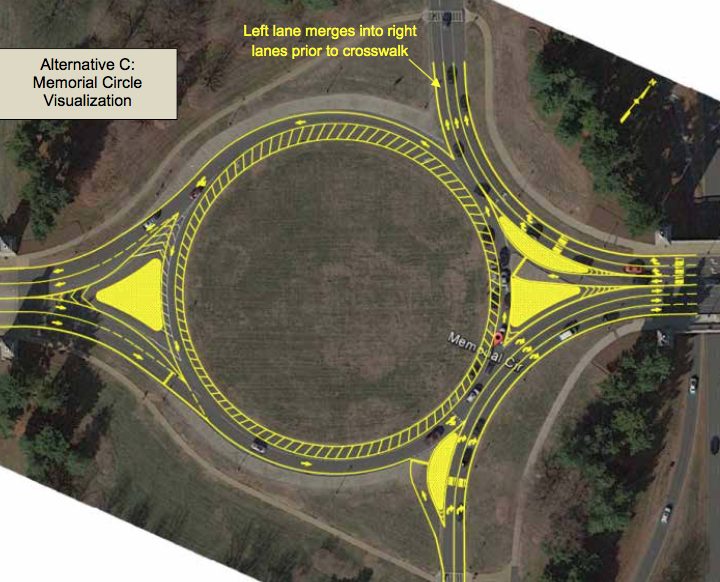
Local Dog Adoption Demand is High — “Kim Williams, who volunteers for the Lost Dog and Cat Rescue Foundation of Arlington, Virginia, has tapped into a puppy pipeline of sorts to bring some of Georgia’s homeless pet population to the mid-Atlantic region where they are bombarded by requests for dogs to adopt.” [WMAZ]

American Reducing Service at DCA — “American Airlines is discontinuing service to more than 20 destinations from Reagan National Airport in January, according to new data reported by the Official Airline Guide. Cities and/or airports dropped range from major (New York-JFK; Las Vegas; St. Louis; Minneapolis-St. Paul) to smaller (Jackson, Miss.; Manchester, N.H.; Greensboro, N.C.). Many were served just once or twice per day.” [InsideNova]

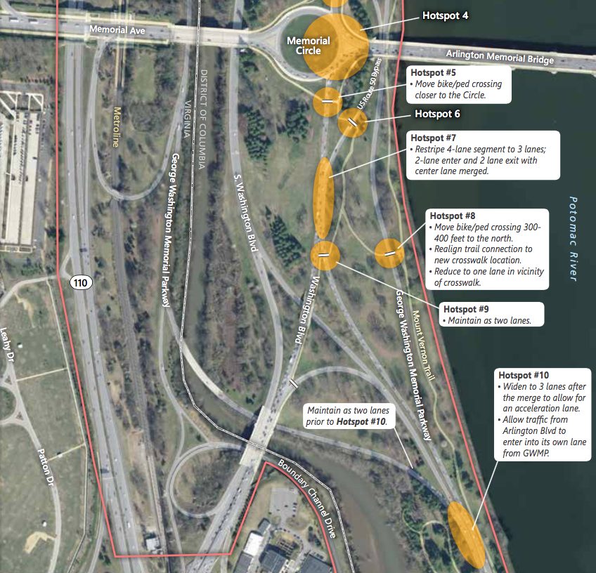
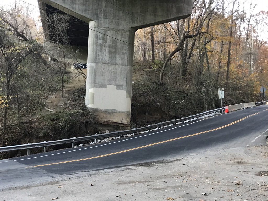
Land Transfer May Speed Bridge Project — “Interesting: NPS is ‘supportive’ of conveying four acres of parkland to VA and DC to construct the Long Bridge(s), rather than just permitting. That would likely speed design and construction, and could result in a ped/bike span that doesn’t compromise as much on width and lighting in order to conform to NPS interests.” [@CarFreeHQ2/Twitter]

Local Wildlife Caught on Camera — “Arlington resident Levi Novey and his wife Alicia have captured footage documenting quite an array of critters passing through their yard via a fence that Levi has dubbed a ‘wildlife superhighway…’ So far their fence camera has photographed foxes, raccoons, mice, housecats, chipmunks, and lots of birds and possums.” [WJLA]

Redistricting Commission Applications Open — “Beginning Monday, Virginians will have a month to apply for one of eight public seats on the state’s new redistricting commission, which has begun its work with a panel of retired judges setting out plans for the application process.” [Washington Post]

Stormy Day Today — “Get ready for a wild weather finish to November. A strong storm system develops and moves through… bringing a mix of hazards to our area in a short time frame, capped off by the potential for strong to possibly severe storms Monday afternoon. No specific warnings or advisories have been issued, but expect a good soaking of one to two-plus inches of rain (and some wild temperature swings).” [Capital Weather Gang, Twitter]


Portions of the Mount Vernon Trail in Arlington should be widened due to heavy use and crash risks, according to a new study.

The National Park Service this month released a report on its Mount Vernon Trail Corridor Study, which examined the condition of the trail, usage patterns and potential improvements.

The trail, which runs along the Potomac from the Rosslyn area to George Washington’s Mount Vernon estate, is used by more than one millions cyclists and pedestrians per year. But its 1970s-era design no longer reflects current engineering standards and the trail’s heavy usage, the report says.

“The trail is relatively narrow by modern standards, and characterized by meandering curves, timber bridges, and in some areas, dense vegetation,” says the report. “The MVT is beginning to show its age, from deteriorating pavement and bridges, to limited accessibility features, and outdated signage and striping. These attributes, combined with increasing usage and user behavior, contribute to risk exposure and considerable crash history.”

There were 225 reported bike and pedestrian crashes on the trail between 2006 and 2010, according to the study. Many of those were at crash hotspots along the trail in Arlington, including near Reagan National Airport, Gravelly Point and the 14th Street Bridge.

“Trail intersections, roadway crossings, surface transitions, and blind curves along the MVT were associated with higher crash and injury rates,” the report says. “On average, the MVT experiences one ambulance call per week related to a bicycle or pedestrian injury.”

“Collisions are more likely to involve male bicyclists (although males are typically overrepresented in the bicycling community),” the study also notes.

Reported crash injuries range include lacerations, bone fractures and head injuries, attributable to both single-person wrecks and collisions between trail users.

Among the near-term (1-4 year) improvements recommended in the report are new way-finding signs, increased trail maintenance, reduced-slip surfaces on bridges, and new “slow zones” at certain points on the trail.

“‘Slow zones,’ including the appropriate signage and pavement markings [could] be used at areas of high conflict among different trail users (e.g., at Arlington Memorial Bridge, Belle Haven Park, Gravelly Point, and other appropriate locations),” the report says.

The recommendations for medium-term changes — potentially 5-7 years away — are more drastic.

The study recommends that portions of the trail in Arlington be reconstructed and widened to at least 11 feet, in accordance with modern multi-use trail standards, compared to the current average 8-9 foot width. Another possibility: separating cyclists and pedestrians in high-traffic areas like Gravelly Point.

That’s in addition to improved trailheads at Crystal City and Gravelly Point, with “more bicycle parking, repair stations, and additional amenities.”

More from the report:

Widening the trail to meet this standard improves trail safety by providing appropriate width to minimize user conflict in high-traffic areas. Focus areas for widening and modernization include:

  • The portion of the trail located between Four Mile Run and the Theodore Roosevelt Island Bridge, pursuant to NEPA analysis. Some segments of trail in this area face widening constraints, but much of this high-use segment could be widened to better align with best practices and serve trail users.
  • Trail intersection enhancements, such as implementing trail roundabouts, at the 14th Street Bridge and Four Mile Run to better manage these conflict areas by slowing bicycle traffic and reducing conflict points.
  • Consider the use of bicycle-pedestrian separation at areas such as Gravelly Point, which have high levels of user conflict and pedestrian use. This could include a designated pedestrian path or increased separation and access control between the trail and adjacent site. A potential trail redesign in this location could also reduce motorist and trail user conflict at the trail intersection with the Gravelly Point parking lot.

A Mount Vernon Trail widening might not sit well with some local activists. A similar proposal, to widen portions of the W&OD Trail in Arlington and provide separate lanes for cyclists and pedestrians is facing opposition from some who have expressed environmental concerns.


A stone’s throw from Crystal City is Roaches Run, a waterfowl sanctuary on the northern flight path to and from Reagan National Airport.

The body of water, surrounded by woods, is home to birds, ducks and dragonflies. Accessible primarily from a small parking lot off the southbound GW Parkway, most human activity is confined to fishing and birdwatching.

But that may eventually change.

Arlington County Board Chair Libby Garvey toured a portion of woods around Roaches Run last week with the chair of Arlington’s Planning Commission and representatives of Crystal City property owner and Amazon landlord JBG Smith.

Though Roaches Run is controlled by the National Park Service and is part of the GW Parkway, JBG owns parcels of land adjacent to the waterfowl sanctuary and could help link it to Crystal City. That would give the rapidly-developing neighborhood newfound accessibility to natural spaces.

“JBG owns a lot of the land over there and is in communication with the Park Service,” Garvey told ARLnow, noting that the developer invited her to last week’s tour. “Can we take this land and turn it into an accessible, usable space for people?”

Garvey said Roaches Run is “a lost area” that’s “not very accessible for anybody” at the moment. Active railroad tracks currently separate it from Crystal City and Long Bridge Park.

JBG declined comment for this story.

Among the ideas for Roaches Run are walking and biking trails, a floating dock for boaters in canoes or kayaks, and bird observation stations. Roaches Run would remain a nature preserve, however, and is not envisioned for other sports or recreation uses.

“It’s going to take some cooperation” to see this idea come to fruition, Garvey said.

The county, the Park Service, JBG and even the Metropolitan Washington Airports Authority would likely be involved. That’s not to mention local civic associations, which have floated the idea of establishing connectivity to Roaches Run from Long Bridge Park and the Mt. Vernon Trail as part a series of improvements to the Crystal City and Pentagon City are dubbed Livability 22202.

“I think it’s an advantage for everybody…. making that whole area spectacular for people,” Garvey said. “You could get on an airplane and go hiking and boating within a mile radius.”

While discussions about Roaches Run have been informal in nature so far, with Amazon moving in nearby and demand for recreational opportunities growing it’s likely to advance to a more formal planning process at some point in the near future.

“It’s all very tentative but this is how ideas start, you have to start somewhere,” Garvey said. “Nothing is happening tomorrow or even next year… it’s probably 5-10 years out.”

Map via Google Maps


NPS Seeking Funds for GW Parkway Upgrades — “[National Park Service] officials are pursuing funding from the U.S. Department of Transportation’s Infrastructure for Rebuilding America grant program to support the [GW Parkway’s] North Section Rehabilitation Program. That program will rebuild a 7.6-mile section of the parkway from Spout Run Parkway to Interstate 495, address serious deterioration of the roadway and implement significant safety improvements.” [InsideNova]

Update on Cupid the Cat — “‪We want to send a HUGE thank you to everyone who has donated so far to Cupid’s recovery! We have been overwhelmed by all of your support, and are so grateful for your kindness and generosity. We’re happy to report that today Cupid is doing really well after his surgery yesterday! He has a good appetite, is getting lots of rest and just wants to spend as much time as possible snuggling with our staff.” [Facebook]

Shirlington Employment Center to Relocate — “Arlington County Board members later this month are slated to approve the move of the Shirlington Employment & Education Center (SEEC) into space at the Arlington Mill Community Center. The non-profit organization will occupy 845 square feet of space on the fourth floor at the center, located at the intersection of Columbia Pike and South Dinwiddie Street. It currently occupies space in the Four Mile Run corridor.” [InsideNova]

Mother Climbs Mountain After Son’s Death — “After losing a teenage son, Henry, to leukemia, Arlington resident Heather Burneson had to take life one step at a time. She took that attitude to the top of Mount Kilimanjaro in Africa on ‘a healing trip,’ for her and several family members.” [Connection Newspapers]

Armed Man Protests at Del. Levine’s House — “A Republican official from Hopewell, Virginia drove to Alexandria this weekend for a small, armed protest outside Delegate Mark Levine’s home in Old Town.” The state lawmaker, who represents parts of Alexandria Arlington and Fairfax County, “said when he found out about the protest, he called the police.” [ALXnow]

Nearby: Local Sears Store Closing — “The Seven Corners Sears is closing April 12. There are deep discounts throughout the store. Signs in the store say all sales are final, no returns are allowed, and points may be redeemed on purchases.” [Annandale Blog]

Flickr pool photo by John Sonderman


N. Glebe Road reopened to drivers within days of the major Nov. 8 water main break near Chain Bridge, but those looking to hike the rugged Potomac Heritage Trail are not as lucky.

Erosion from the torrent of water unleashed by the break in the 36-inch distribution line washed away a portion of the trail that connects the southern section that’s accessible from the Roosevelt Island parking lot with the section north of Chain Bridge.

“The Potomac Heritage Trail is currently closed south of the Arlington County parking lot at the intersection of Glebe Road and Chain Bridge Road,” says an alert the National Park Service’s GW Parkway website. “The NPS is working with Arlington County and the PATC to identify a temporary re-route and a plan to reopen.”

NPS spokesman Aaron LaRocca confirmed to ARLnow that the closure was “due to trail damage as a result of the water main break on Glebe Road.”

So far there’s no word about when the trail might reopen.


The Memorial Bridge rehabilitation project is halfway complete.

The bridge is back open today after a total closure over the weekend (delayed from earlier this month) that allowed crews to replace concrete support structures and panels, along with other work, on the southern side of the span.

The National Park Service released a new video (above) highlighting work so far on the $227 million project, which kicked off last fall. The video notes that the bridge is “a symbolic link between north and south” and “a symbolic entrance to our nation’s capital.”

It took years to secure federal funding for the project, as warnings of the bridge crumbling and becoming unusable grew more dire.

More on the construction progress so far, from NPS:

Over the weekend, workers finished preparing the southside of the bridge for users and made changes to transition to the next phase of the rehabilitation project. The work included:

  • Moving the bridge’s center barrier.
  • Striping the southside of the bridge for drivers.
  • Moving the poles that support overhead lights guiding drivers in three reversible lanes.
  • Installing or uncovering new detour signs for pedestrians and bicyclists.

The total rehabilitation of Arlington Memorial Bridge began in fall 2018 and is on schedule.  So far, workers have:

  • Replaced the concrete structures that support the southside of the bridge.
  • Installed new pre-cast concrete panels to replace half of the bridge deck.
  • Placed new steel beams on the southside of the bridge.
  • Cleaned, repaired and reinstalled the bridge’s historic granite balustrade.

“Since its dedication in 1932, Arlington Memorial Bridge has served as a monument to national sacrifice and valor — a symbol of reunification, spanning the historic divisions of the North and South,” NPS said of the bridge, which connects Arlington and D.C. across the Potomac River. “As one of the largest transportation infrastructure projects in National Park Service history, the rehabilitation of Arlington Memorial Bridge will give new life to our Capital’s ceremonial entrance while respecting its character, history and national significance.”


Cyclists can now ride e-bikes around national parks, including the Mt. Vernon Trail along the GW Parkway, thanks to a recent policy change from the National Park Service.

“We think this is a very positive development, and we are hopeful that this serves as a push for Arlington’s parks department to allow e-bikes everywhere,” said Henry Dunbar, director of active transportation for Bike Arlington.

According to the NPS e-bike policy, bike speeds of up to 28 mph will be allowed in all national parks. However, similar to traditional bicycles, e-bikes will not be permitted in designated wilderness areas.

“They make bicycle travel easier and more efficient, and they provide an option for people who want to ride a bicycle but might not otherwise do so because of physical fitness, age, disability, or convenience, especially at high altitudes or in hilly or strenuous terrain,” said National Park Service Deputy Director P. Daniel Smith in a statement from NPS.

The scenic trail is now the second bike trail in Arlington where people can ride the motor-assisted bicycle, after the W&OD Trail go-ahead from NOVA Parks in March.

“The only downside would be managing trail safety and congestion, which we already have issues with,” Dunbar said.

Recently officials have discussed plans to widen the W&OD Trail to ease bike-pedestrian conflicts, along with improving lighting, crossings, and signage.

The news pleased actor William Shatner, of Star Trek fame, who has since become an e-bike enthusiast (and the face of Pedego Electric Bikes, albeit not available in Arlington). Shatner butted heads with Arlington’s Department of Environmental Services in November for its “barbaric” e-bike ban.

“A regular bicyclist can easily travel 25mph!” Shatner tweeted Tuesday. “So if they allow bikes what would be the additional impact of an e-bike?”

https://twitter.com/WilliamShatner/status/1168915055976562688?s=20


The National Park Service (NPS) will host a special event near Rosslyn on Sunday (Aug. 25) to commemorate the 400th anniversary of the first slaves arriving in the English colonies.

The Park Service is hosting events throughout the region as a day of remembrance for the first slave ship’s arrival at Point Comfort and the centuries of oppression that followed.

The Arlington event is scheduled to begin at 2 p.m. at the Netherlands Carillon, near the Iwo Jima memorial.

According to the event page:

Beginning at 2 p.m. park rangers from George Washington Memorial Parkway will offer opportunities for visitors to explore themes of remembrance, healing and reconciliation related to African American history at the Netherlands Carillon in Arlington Ridge Park. Visitors are encouraged to bring their own bells to ring alongside the carillon at 3 p.m. The carillonneur will also play African American hymns and musical selections that reflect the African American experience.

Image via National Park Service


(Updated at 10:10 a.m.) Dutch artist Gijsbert Kok plays an instrument similar to an organ — except it controls bells instead of pipes.

The instrument is called a carillon and Kok will be playing it during his performance at the Netherlands Carillon, near Rosslyn and the Iwo Jima memorial, this Saturday (July 20).

Kok’s performance in Arlington is part of the free weekly concerts hosted by the National Park Service (NPS) through the end of the summer. The concerts run from 6-8 p.m., except for the September 2 event, which will take place from 2-4 p.m.

Guests can bring lawn chairs, blankets or simply sit on the grass. NPS suggests that guests park or arrive via the Rosslyn Metro, which is about a 15-minute walk. Parking is available at the U.S. Marine Corps War Memorial.

This year’s concert lineup for the remainder of the summer is as follows:

  • July 20 — Gijsbert Kok, Bodegraven, The Netherlands
  • July 27 — Doug Gefvert, King of Prussia, Pennsylvania
  • August 3 — Edward M.Nassor, Fairfax, Virginia
  • August 10 — Lynnli Wang, Washington, D.C.
  • August 17 — Edward M. Nassor, Fairfax, Virginia
  • August 24 — Elisa Tersigni, Washington, D.C.
  • August 31 — Jesse Ratcliffe, Warrenton, Virginia
  • September 2 — Edward M. Nassor, Fairfax, Virginia

In addition to his bell ringing, Kok is also an organist who performs at churches and for concerts across the United States and Europe.

The National Park Service received the carillon as a gift from the Netherlands in commemoration of the United States’ assistance during World War ll. It is comprised of 50 bells, weighing over 30 tons. The bells are set to be removed this fall and sent via ship back to the Netherlands for cleaning as part of a major rehabilitation project.

Photo (1) via Joseph Gruber/Flickr, map via Google Maps


Last Week of School — The 2018-2019 school year is concluding this week for Arlington Public Schools. Today is the last day of school for high schools, while Friday is the last day of school for middle and elementary schools. [Arlington Public Schools]

Park Service Advances Boathouse Plan — “Plans to establish a community boathouse on the Potomac River in Arlington just passed a major milestone. The National Park Service completed its Environmental Assessment (EA) with a Finding of No Significant Impact (FONSI), which sets up the project to move forward.” [Arlington County, Twitter]

State of the County Address — “Christian Dorsey began his State of the County address by thanking the Arlington Chamber of Commerce and the Arlington business community for their partnership ‘on specific issues from the transient occupancy tax, to dedicated funding for the Metro, to helping us put our best foot forward in the competition for  Amazon’s HQ2.'” [Press Release]

Arlington Public Safety Awards — “Following the State of the County address, awards were presented to honor Arlington County’s public safety personnel…  Stories of their heroic actions include two firefighters rescuing a person trapped inside a vehicle that was fully submerged in water, a detective dismantling a large, local cocaine trafficking organization with limited investigative leads, and a police officer saving two unresponsive passengers in an overturned, burning vehicle on the roadway.” [Press Release]

Fraud Alert from Arlington Police — “The Arlington County Police Department and Sheriff’s Office are warning the public about a telephone scam that uses the threat of arrest to extort money from potential victims.” [Arlington County]

Metro Studying Second Rosslyn Metro Station — “After decades of discussion, Metro kicked off a study this week of a new, second station at Rosslyn and other changes that could overhaul the way trains on the Blue, Orange and Silver lines run throughout the system.” [WTOP]

ACPD: No Plans for ‘Mass Deportation’ — “The Arlington County Police Department called the plan ‘political’ and said they have no intention on working with Immigration and Customs Enforcement to fulfill [President] Trump’s mass deportation plan. The Fairfax County Police Department said it doesn’t participate with ICE on civil enforcement either.” [Fox 5]

Photo courtesy Dennis Dimick


(Updated at 4:25 p.m.) The National Park Service is ready to move ahead with plans to make Memorial Circle safer and easier to navigate.

NPS finalized a study last week, stating its plans did not negatively impact the surrounding environment or historical character of the area. The agency can now move forward on making the nexus of roadways safer for drivers, pedestrians, and bicyclists.

“The National Park Service is very pleased this project has advanced to a stage where we’ll be able to implement these improvements as soon as funds are available,” a spokesman for the federal agency told ARLnow.

NPS chose the most aggressive of three proposed plans to modify Memorial Circle and the roads around it, S. Arlington Blvd and Washington Blvd.

The plan chosen, Alternative C, calls for changes like re-striping Memorial Circle down to one lane of traffic instead of two, thus reducing conflicts between drivers in the circle and approaching the circle.

The plan also includes a proposal to enlarge and shorten the text on signs in the circle, making them easier to read. Additionally, new yield signs would give vehicles inside the circle the right of way.

NPS also proposed adding walk signals for pedestrians and flashing beacons for drivers at six intersections where the study notes near-misses are common. Officials estimated 600 crashes occurred near Memorial Circle between 2005 and 2012.

The agency would also re-stripe S. Arlington Blvd down to two lanes before it approaches the crosswalk just north of the circle to make crossing safer for pedestrians.

To help reduce weaving between lanes and merging traffic north of the circle, NPS would:

  • Re-stripe Washington Blvd, reducing it to one lane
  • Re-stripe S. Arlington Blvd to two lanes and Washington Blvd to one lane where the roadways merge, allowing traffic to continue without changing lanes
  • Remove the S. Arlington Blvd exit ramp and far left exit lane to S. Washington Blvd
  • Widen the northern ramp off of S. Arlington Blvd up to 12 feet to allow two lanes of traffic to exit, making the left lane exit-only and the right lane a shared exit/through lane
  • Possibly remove one or two trees along the exit of the S. Arlington Blvd ramp

The plan also calls for widening northbound Washington Blvd to fit a third lane as it merges into the circle.

The widened road would make room for a concrete island, directing two of Washington Blvd’s three northbound lanes onto Memorial Bridge and one lefthand lane into the circle. NPS said Washington Blvd could be widened up to 20 feet, pending design specifications.

The existing concrete island where the Memorial Bridge meets the circle’s east side would be split into two. These two new concrete islands would direct the left westbound lane coming off Arlington Memorial Bridge into the circle and syphon the other westbound lanes onto S. Arlington Blvd.

Other changes include:

  • Adding rumble strips and raised pavement markings to avoid “last-minute weaving” and provide more guidance to drivers
  • Installing more speed limit signs and increased police presence to crack down on speeding

NPS has implemented traffic improvements to the area before. In 2012, the agency moved a sidewalk and installed rumble strips, among other changes, on the GW Parkway in a bid to make the roadway safer.

“Whether you are a frequent commuter, visitor to Washington, D.C. or someone recreating, we want the Memorial Circle area to be a safe and accessible experience for everyone,” said Charles Cuvelier, the Parkway’s superintendent, in a statement about the latest round of improvements.

Work continues nearby on structural repairs to Memorial Bridge, a project NPS started last year.

Image 2 via Google Maps, images 1 and 3-5 via National Park Service


View More Stories