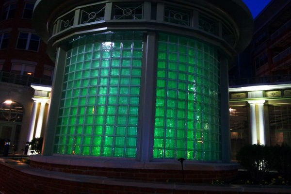
Green lights in Clarendon

911 Outage Report Released — A report regarding Northern Virginia’s 911 outage following last summer’s derecho storm calls on Verizon to provide an audit of its entire 911 infrastructure. The Metropolitan Washington Council of Governments (MWCOG) Board of Directors approved the report, which found that the outage was caused by the loss of commercial power and the subsequent failure of one of the two backup generators in each of Verizon’s Arlington and Fairfax central offices. Improper maintenance and incident response also reportedly contributed to the outage. [MWCOG]

Arlington Third Healthiest County in Virginia — A study by the Robert Wood Johnson Foundation and University of Wisconsin researchers indicates that Arlington is the third healthiest county in the state. Coming in first is Fairfax County, followed by Loudoun County. The study examined data from nearly every county in the nation. Overall, Northern Virginia counties fared better than those in the southern parts of the state. [WTOP]

Key Elementary School Educator Chosen as Teacher of the Year — The 2013 Arlington Public Schools Teacher of the Year is a fourth grade educator at Key Elementary School. Erica Russell has been teaching at the school since 2006. She will be honored by the School Board on May 15, and is the county’s nominee for the 2013 Virginia Teacher of the Year Competition. [Sun Gazette]


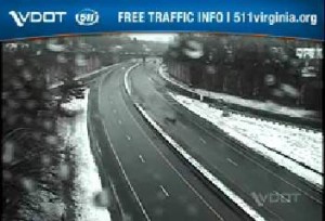
395-glebe-snowSo far, the so-called Snowquester snowstorm has been largely a bust in Arlington.

While northern and western parts of the county have some slushy snow cover (see photo of I-66 and Glebe Road, left), many points south and east have nary a sign of the white stuff.

Arlington County says roads are currently passable, but crews are prepared for the possibility of additional snowfall this afternoon. From a press release:

Arlington County Government and Arlington Public Schools are closed today.

Arlington snow crews have been working since midnight. We activated full shifts of 12 hours each; at 12 noon the second shift will come in. The overnight crew has been traveling County roads and spreading salt and brine. These shifts will continue throughout the storm and extend into the days following, as needed.

At this hour, our crews report that roads remain passable, with little actual accumulation, though we continue to urge everyone to stay off the roads if possible. We expect significant snow accumulation later this afternoon, tapering off into the evening hours.

Dominion Power is reporting one small power outage, which may not be storm-related. View the Dominion interactive outage map.

For useful phone numbers, tips, information, cancellations, etc., visit Snow & Ice Central. If you have not already done so, sign up for Arlington Alert to receive free emergency text messages.

And, just for fun, please share your Snowquester photos with our Flickr group.


Despite sunny skies and relatively mild temperatures this afternoon, forecasters have issued another reminder that the D.C. area will be blanketed with snow tomorrow.

The National Weather Service has issued a Winter Storm Warning, upgrading the previous Winter Storm Watch. Forecasters say we’re likely to get 4-8 inches of snow tomorrow (Wednesday).

… WINTER STORM WARNING IN EFFECT FROM MIDNIGHT TONIGHT TO 3 AM EST THURSDAY…

THE NATIONAL WEATHER SERVICE IN BALTIMORE MD/WASHINGTON HAS ISSUED A WINTER STORM WARNING FOR SNOW… WHICH IS IN EFFECT FROM MIDNIGHT TONIGHT TO 3 AM EST THURSDAY. THE WINTER STORM WATCH IS NO LONGER IN EFFECT.

* PRECIPITATION TYPE… SNOW.

* ACCUMULATIONS… 4 TO 8 INCHES WITH THE HIGHER AMOUNTS WEST OF INTERSTATE 95.

* TIMING… RAIN MIXING WITH AND CHANGING TO WET SNOW FROM SOUTHWEST TO NORTHEAST TONIGHT AND WEDNESDAY MORNING. SNOW MAY BE MODERATE TO HEAVY AT TIMES WEDNESDAY. SNOW TAPERS OFF WEDNESDAY NIGHT.

* TEMPERATURES… IN THE MID 30S.

* WINDS… NORTHEAST 15 TO 25 MPH. GUSTS UP TO 35 MPH WEDNESDAY AFTERNOON AND NIGHT.

* IMPACTS… SNOW COVERED ROADS WILL MAKE TRAVEL DIFFICULT. HEAVY WET SNOW AND GUSTY WINDS COULD LEAD TO POWER OUTAGES WEDNESDAY AFTERNOON AND NIGHT.

PRECAUTIONARY/PREPAREDNESS ACTIONS…

A WINTER STORM WARNING FOR HEAVY SNOW MEANS SEVERE WINTER WEATHER CONDITIONS ARE EXPECTED OR OCCURRING. SIGNIFICANT AMOUNTS OF SNOW ARE FORECAST THAT WILL MAKE TRAVEL DANGEROUS. ONLY TRAVEL IN AN EMERGENCY. IF YOU MUST TRAVEL… KEEP AN EXTRA FLASHLIGHT… FOOD… AND WATER IN YOUR VEHICLE IN CASE OF AN EMERGENCY.

Meanwhile, the Metropolitan Washington Airports Authority says travelers should expect delays and cancellations over the next 36 hours or so.

Reagan National and Dulles International Airports are operating normally. An approaching winter storm is affecting flights to and from Chicago today. We anticipate winter weather will affect flight operations here on Wednesday, March 6. Check with directly with your airline to monitor the status of your flight and determine if flight rebooking is necessary.

Our airport snow removal personnel and equipment are prepared for the storm. We will update this page with further information when the winter weather arrives.


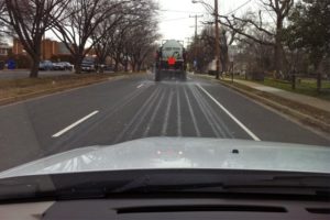
Arlington County crews pretreating S. Glebe Road with brine (file photo)Arlington County is prepping roads ahead of a winter storm that could create icy conditions tomorrow (Saturday).

Crews are out today pre-treating roads with a brine solution. They’re focusing on primary (red) and secondary (blue) routes, which can be seen on the county’s online 2012-2013 snow map. Workers will deploy from 4:00 a.m.-4:00 p.m. tomorrow to treat and plow roads as necessary during the storm.

Although areas north and west of D.C. may get around 4 inches of snow, significant accumulation isn’t expected in Arlington. The Capital Weather Gang’s forecast currently calls for a warm up on Saturday afternoon that should change the snow to rain or a wintry mix. However, a snow crew will remain on call through Sunday morning to treat icy roads in case a re-freeze occurs.

The Department of Environmental Services encourages residents to stay informed and to be prepared with extra food and water in case the storm worsens. Residents are also asked to avoid parking on the street, if possible, or to coordinate with neighbors to only park on one side of the street. Snow removal vehicles need a width of at least 15 feet to pass down a street.

The National Weather Service issued a Hazardous Weather Outlook for the D.C. area, noting that it’s still unclear exactly where the worst of the storm will hit. An excerpt from the advisory follows:

.THIS HAZARDOUS WEATHER OUTLOOK IS FOR THE MARYLAND PORTION OF THE
CHESAPEAKE BAY…TIDAL POTOMAC RIVER…AND ADJACENT COUNTIES IN
CENTRAL MARYLAND AND NORTHERN VIRGINIA AS WELL AS THE DISTRICT OF
COLUMBIA.

DAY ONE…TODAY AND TONIGHT

A STORM SYSTEM WILL BRING WINTRY PRECIPITATION TO THE AREA LATE
TONIGHT. THE HIGHEST CONFIDENCE OF ACCUMULATING SNOWFALL RESIDES
ACROSS PORTIONS OF CENTRAL MARYLAND WHERE A WINTER WEATHER
ADVISORY IS IN EFFECT BEGINNING LATE TONIGHT. PLEASE REFER TO
WBCWSWLWX FOR FURTHER DETAILS.

.DAYS TWO THROUGH SEVEN…SATURDAY THROUGH THURSDAY

THE WINTER WEATHER ADVISORY FOR PORTIONS OF CENTRAL MARYLAND
CONTINUES ON SATURDAY. FURTHER SOUTH INCLUDING THE GREATER
WASHINGTON METRO AREA…THERE REMAINS SOME UNCERTAINTY REGARDING
WHERE THE RAIN/SNOW LINE WILL SET UP AND EXACTLY HOW MUCH SNOW
WILL FALL. IT IS POSSIBLE THAT THE WINTER WEATHER ADVISORY MAY
NEED TO BE EXPANDED FURTHER SOUTH…SO PLEASE MONITOR THE LATEST
FORECASTS.

A SMALL CRAFT ADVISORY MAY BE NEEDED FOR PORTIONS OF THE WATERS
LATE SATURDAY NIGHT AND SUNDAY.


Capital Bikeshare is back in business following Superstorm Sandy, but cyclists are warned that hazardous conditions remain on the streets and trails.

Capital Bikeshare did not experience damage to any of its bicycles or docking stations, we’re told. The system did shut down for about 36 hours to prevent people from biking in dangerous conditions, and to protect the workers who have to travel around the metro area to re-distribute bikes where they’re needed.

The system began running again on Tuesday afternoon, and workers spent some time playing catch up on bike re-distribution.

Although larger obstacles such as fallen trees or downed wires still pose a problem for cyclists, BikeArlington’s Chris Eatough said such hazards are relatively easy to spot and shouldn’t take too many people by surprise. The lingering issue that might catch cyclists off guard is wet ground covered with slick leaves.

“The main thing we’ve heard and that I’ve noticed is slippery conditions. A lot of leaves came down along with everything else. They’ve come down so heavily saturated that in many cases they’re matted to the trails and roads,” Eatough said. “It’s definitely something to watch out for. That could take you off your bike before you even know what’s going on.”

Cyclists are reminded to control their speeds and use extra caution when turning. As always, cyclists should use a light when traveling in the dark. Eatough said the light is particularly important to have as darkness sets in earlier, especially with daylight saving time beginning on Sunday (November 4).

Cyclists looking for the latest biking conditions, including those on the trails, can check in online with the Washington Area Bike Forum or follow BikeArlington’s Twitter feed.


Humans aren’t the only ones suffering the effects of Superstorm Sandy. The storm apparently forced some beavers out of their habitats and into the streets of Pentagon City.

A few residents who live in a condo complex on S. Hayes Street were about to head out this morning when they were surprised by a wet, furry visitor.

The residents called animal control upon encountering the beaver scurrying from door to door. Desiree Lomer-Clarke said the animal control worker who came to the scene reported having to deal with two other beavers earlier this morning.

“Apparently their dam broke and they scattered from fear of drowning,” said Lomer-Clarke. “The other beavers were pushed towards bodies of water, but this one had to be trapped and released near its home.”

Arlington County naturalist Greg Zell said the animal sightings might indeed be weather related. The beavers may have chosen to leave if the pocket of air that’s typically present in their dens was compromised.

“It’s possible that high water could have driven them temporarily out of their homes,” Zell said. “It’s the first time I would have seen it in this area, but it’s certainly possible.”

Zell further explained that beavers ending up in a residential area is fairly unusual because they don’t seek out human interaction.

“Beavers are generally going to move away from people,” said Zell. “They eat sticks and twigs so they’re not attracted to people’s food and trash. This sounds like they were just homeless and cruising around.”

Because they avoid humans, there have been rare occasions when beavers have attacked a person or pet that came too close their dens and was deemed a threat. Zell recommends that anyone who encounters a beaver tries to avoid it, as with all wild animals. He said making loud noises, such as clapping, is often enough to send a beaver on its way.

The displaced beavers were not acting in an erratic manner to suggest they would have rabies — as happened twice this summer during beaver attacks in Fairfax County — so they were released near their homes.

As the area’s water levels return to normal, Zell said the beavers that wandered Pentagon City should be able to once again inhabit their dens. If the dens were damaged or destroyed by the storm, the animals should adjust easily to a new habitat.

“Beavers are very adaptable, they tolerate cold very well. They have a thick layer of fur and fat,” Zell said. “They’ll just find another place to go.”

Photo by Robert Dogan


Update at 11:10 p.m. — There are now 18,050 Dominion customers without power in Arlington.

Update at 7:25 p.m. — The number of Dominion customers without power in Arlington is up to 16,828.

(Updated at 6:10 p.m.) More than 5,800 Dominion customers are without power in Arlington as of 6:05 p.m. as the strongest winds from Hurricane Sandy have started to arrive in the area.

Twitter users have been reporting power outages in the Buckingham area, in Westover Village, Lyon Park and in Crystal City, among other areas. Another large outage is being reported by Dominion in the far northeastern corner of Arlington County. Power has also been flickering in the Ballston, Clarendon, Courthouse and Pentagon City areas.

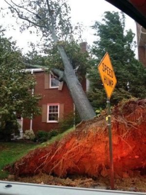
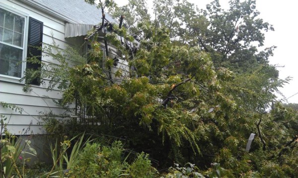
Wind gusts have been picking up over the past hour. Numerous reports of trees and wires down around the county have been pouring in to Arlington’s Emergency Communications Center. Currently, firefighters are on the scene of a tree that fell into a house, causing significant damage, on the 4800 block of 26th Street N. in the Yorktown area (pictured, left). No injuries were reported.

Additional calls for trees falling onto houses and are being dispatched. A large tree fell into the intersection of 5th Street S. and S. Harrison Street, according to firefighters on the scene.

Arlington County announced today that all county offices, libraries, courts, schools, community centers and nature centers will be closed on Tuesday. ART bus service has also been suspended on Tuesday.

Photo courtesy @CAPT258


The rain and wind from Hurricane Sandy is about to get worse, Arlington County said in an emergency alert this afternoon (below).

County officials compared the dangerous conditions Arlington will experience over the next 24 hours to the heavy winds of the June 29 derecho, which lasted 24 minutes.

Already some power problems and falling trees and power lines have been reported. Dominion reported 423 customers without power in Arlington earlier this afternoon, but power has since been restored to most. Firefighters are currently on the scene of a large tree that fell on to a house on the 2900 block of N. Oxford Street, in the Bellevue Forest neighborhood. The house was unoccupied at the time and nobody was hurt.

In the following Arlington Alert, the county says they’re starting to receive reports of flooded roads. Long Bridge Drive has already been closed due to flooding.

Hurricane Sandy is about to get worse.

Think of the derecho storm with high winds in June that lasted 24 minutes. The winds we’re about to experience beginning this afternoon are like the derecho, but they will last for 24 hours.

To paraphrase: Instead of 24 minutes of dangerous winds, it will be 24 hours of dangerous conditions.

We need you to stay off the roads and indoors as travel will become extremely dangerous with winds and heavy rain beginning this afternoon.

Several inches of rain and potential flooding could start happening. We’re beginning to get reports of flooded roads.

Have your battery-powered radio available and make sure your phone is fully charged if you lose power. We will share any shelter openings and other updates via our information channels such as our Emergency Management Blog, County Web Page and Arlington Alert.

Separately, the county is advising residents to secure loose items outside, if that can be done safely, and to avoid driving into high standing water. “Please exercise extreme caution” in the storm, the county said.

As high winds approach, exercise extreme caution. For the safety of our employees, Arlington County will implement its high-wind policy. As the wind approaches sustained speeds of 30-40-45 miles-per-hour, we will pull crews off the roads and in to a safe place. This includes Parks staff, who will suspend responding to downed tree calls during these dangerous wind conditions. As winds approach very high, sustained speeds, police and fire personnel will respond only to life-threatening calls.

Please exercise extreme caution; emergency managers urge you to go a safe place and stay there. We also encourage you to remove/secure loose items from your yard, balcony, deck, etc., as these could become dangerous projectiles in high wind. Do this if you can do so safely.

Monday & Tuesday trash and recycling services are delayed until Wednesday. Bring your trash carts and recycling bins into your house/garage; do not leave them outside, as they could become airborne and dangerous.

Also, it’s a good idea to remove or secure loose items from your yard, balcony, deck, etc., as these could become dangerous projectiles in high wind. Do this if you can do so safely.

We are receiving reports of ponding on some roads. Standing water is deceptive; do not drive into standing water. Do not go out onto the roads if at all possible; we urge you to get to a safe place and stay there.

  • Do not drive into standing water. If floodwaters rise around your car, abandon the car and move to higher ground if you can do so safely. You and the vehicle can be quickly swept away.
  • Six inches of water will reach the bottom of most passenger cars, causing loss of control and possible stalling.
  • A foot of water will float many vehicles .
  • Two feet of rushing water can carry away most vehicles including SUVs and pick-ups.

Update at 9:10 p.m. — The storm is expected to impact Arlington within the next hour.

… STRONG THUNDERSTORM TO AFFECT ARLINGTON… MONTGOMERY… PRINCE WILLIAM/MANASSAS/MANASSAS PARK… PRINCE GEORGES… LOUDOUN AND FAIRFAX COUNTIES…

AT 858 PM EDT… A STRONG THUNDERSTORM WAS LOCATED OVER CENTREVILLE… MOVING EAST AT 20 MPH.

LOCATIONS IMPACTED INCLUDE FAIRFAX… OAKTON… MANTUA… VIENNA… THE I66 AND I495 INTERCHANGE… MERRIFIELD… DUNN LORING… TYSONS CORNER… PIMMIT HILLS AND FALLS CHURCH.

THIS STORM IS PRODUCING FREQUENT CLOUD TO GROUND LIGHTNING. MOVE INDOORS IMMEDIATELY FOR YOUR SAFETY. IF YOU CAN HEAR THUNDER… YOU ARE CLOSE ENOUGH TO BE STRUCK BY LIGHTNING.

HEAVY RAIN WITH THIS STORM WILL REDUCE VISIBILITIES TO BELOW ONE MILE AND MAY CAUSE PONDING OF WATER ON ROADWAYS.

WIND GUSTS OF UP TO 40 MPH CAN BE EXPECTED WITH THIS STORM.

The National Weather Service has issued a Severe Thunderstorm Watch for the D.C. area through midnight tonight (Thursday). A line of rain and strong storms are slowly approaching from the west.

From Arlington Alerts:

The National Weather Service has issued a Severe Thunderstorm Watch for all of the Metro Area, effective until 12 midnight. The current most likely time of thunderstorm arrival is between 7:30 and 9:15 PM. Storms are moving east at 15 mph with reported 60 mph wind gusts.


Update at 3:45 p.m. — Police are reporting high standing water on eastbound Route 50 in the area of Courthouse.

Update at 3:30 p.m. — Dominion is reporting only 93 customers without power in Arlington at this time.

Update at 3:20 p.m. — A tree has fallen into a house in the Claremont neighborhood, knocking over the chimney, according to scanner traffic. The tree also struck some power lines.

Update at 2:55 p.m. — The National Weather Service has just issued a Flash Flood Warning for Arlington and the surrounding area.

BULLETIN – EAS ACTIVATION REQUESTED
FLASH FLOOD WARNING
NATIONAL WEATHER SERVICE BALTIMORE MD/WASHINGTON DC
250 PM EDT TUE SEP 18 2012

THE NATIONAL WEATHER SERVICE IN STERLING VIRGINIA HAS ISSUED A

* FLASH FLOOD WARNING FOR… THE DISTRICT OF COLUMBIA… MONTGOMERY COUNTY IN CENTRAL MARYLAND… CITY OF FALLS CHURCH IN NORTHERN VIRGINIA… ARLINGTON COUNTY IN NORTHERN VIRGINIA… NORTHWESTERN PRINCE GEORGES COUNTY IN CENTRAL MARYLAND… NORTHERN FAIRFAX COUNTY IN NORTHERN VIRGINIA…

* UNTIL 545 PM EDT

* AT 246 PM EDT…NATIONAL WEATHER SERVICE DOPPLER RADAR INDICATED VERY HEAVY RAIN CAPABLE OF PRODUCING FLASH FLOODING. RADAR ESTIMATES THAT ADDITIONAL RAINFALL AMOUNTS OF UP TO 2 INCHES CAN BE EXPECTED. AN INCH OF RAIN MAY FALL IN AS LITTLE AS 15 MINUTES…WHICH WILL RAPIDLY CAUSE PONDING OF WATER ON ROADWAYS. ADDITIONAL RAIN WOULD LEAD TO FLASH FLOODING.

* SOME LOCATIONS THAT ARE AFFECTED BY THE HEAVY RAIN INCLUDE ARLINGTON…BALLSTON…CHANTILLY…FALLS CHURCH…GREAT FALLS… HERNDON…MCLEAN…RESTON…ROSSLYN…TYSONS CORNER…VIENNA… BETHESDA…CHEVY CHASE…COLESVILLE…GAITHERSBURG… GERMANTOWN…OLNEY…POTOMAC…ROCKVILLE…TAKOMA PARK… ANACOSTIA…GEORGETOWN…DOWNTOWN WASHINGTON.

EXCESSIVE RUNOFF FROM HEAVY RAINFALL WILL CAUSE FLASH FLOODING OF SMALL CREEKS AND STREAMS…URBAN AREAS…HIGHWAYS…STREETS… UNDERPASSES AND OTHER DRAINAGE AREAS AND LOW LYING SPOTS.

The National Weather Service has issued a Severe Thunderstorm Warning for Arlington through 3:15 p.m.

Forecasters are warning of very dangerous conditions during the storm, which is approaching from the southwest.

THE NATIONAL WEATHER SERVICE IN STERLING VIRGINIA HAS ISSUED A

* SEVERE THUNDERSTORM WARNING FOR… THE WESTERN DISTRICT OF COLUMBIA… MONTGOMERY COUNTY IN CENTRAL MARYLAND… CITY OF FAIRFAX IN NORTHERN VIRGINIA… CITY OF FALLS CHURCH IN NORTHERN VIRGINIA… CITY OF MANASSAS IN NORTHERN VIRGINIA… ARLINGTON COUNTY IN NORTHERN VIRGINIA… CITY OF MANASSAS PARK IN NORTHERN VIRGINIA… CITY OF ALEXANDRIA IN NORTHERN VIRGINIA… PRINCE WILLIAM COUNTY IN NORTHERN VIRGINIA… SOUTHEASTERN LOUDOUN COUNTY IN NORTHERN VIRGINIA… EASTERN FAUQUIER COUNTY IN NORTHERN VIRGINIA… FAIRFAX COUNTY IN NORTHERN VIRGINIA…

* UNTIL 315 PM EDT

* AT 213 PM EDT… SEVERE THUNDERSTORMS WERE DETECTED ALONG A LINE EXTENDING FROM WARRENTON TO BEALETON… AND WERE MOVING NORTHEAST AT 50 MPH. THIS LINE OF STORMS IS CAPABLE OF PRODUCING DAMAGING WINDS IN EXCESS OF 60 MPH. SEVERE WINDS ARE EXPECTED DESPITE VERY LITTLE LIGHTNING BEING ASSOCIATED WITH THIS LINE.

* LOCATIONS IMPACTED INCLUDE… HAYMARKET… MANASSAS… BULL RUN… ARCOLA… SOUTH RIDING… CENTREVILLE… LAKE RIDGE…

PRECAUTIONARY/PREPAREDNESS ACTIONS…

THIS IS A DANGEROUS LINE OF STORMS. IF YOU ARE IN ITS PATH… MOVE INDOORS TO A STURDY BUILDING AND STAY AWAY FROM WINDOWS. WHEN IT IS SAFE TO DO SO… REPORT SEVERE WEATHER TO LOCAL LAW ENFORCEMENT OR TO THE NATIONAL WEATHER SERVICE.

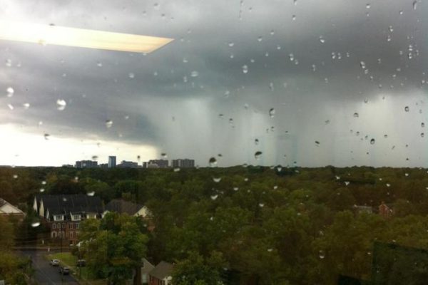
Photo (above) courtesy @jdhague4. Photo (below) courtesy WJLA.


View More Stories