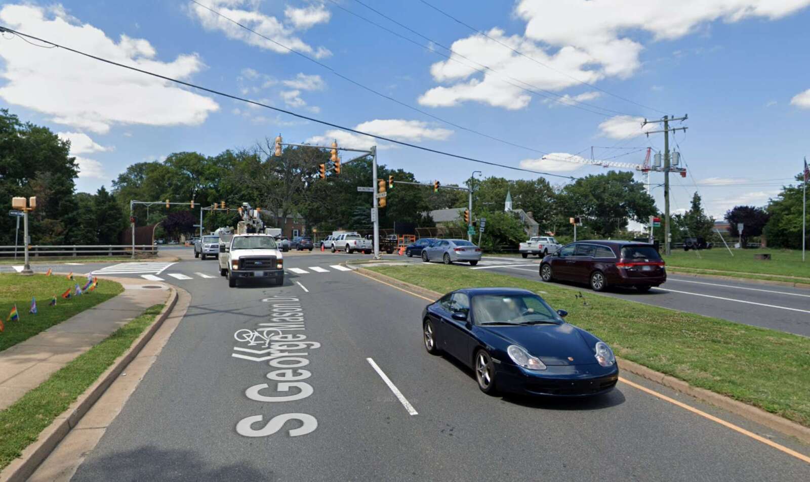
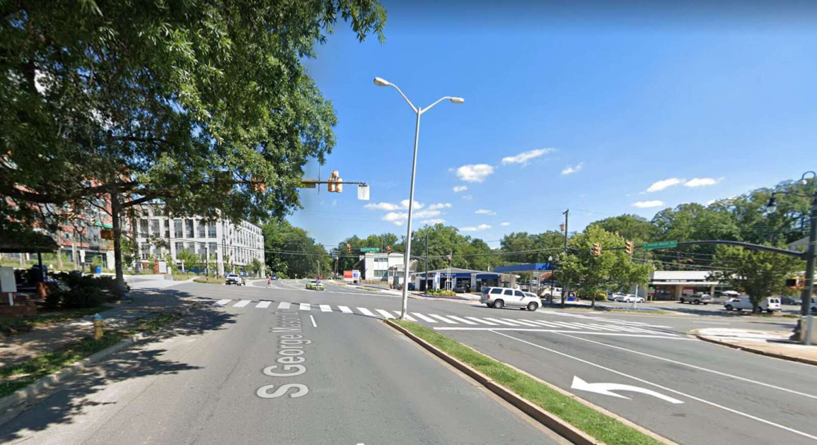
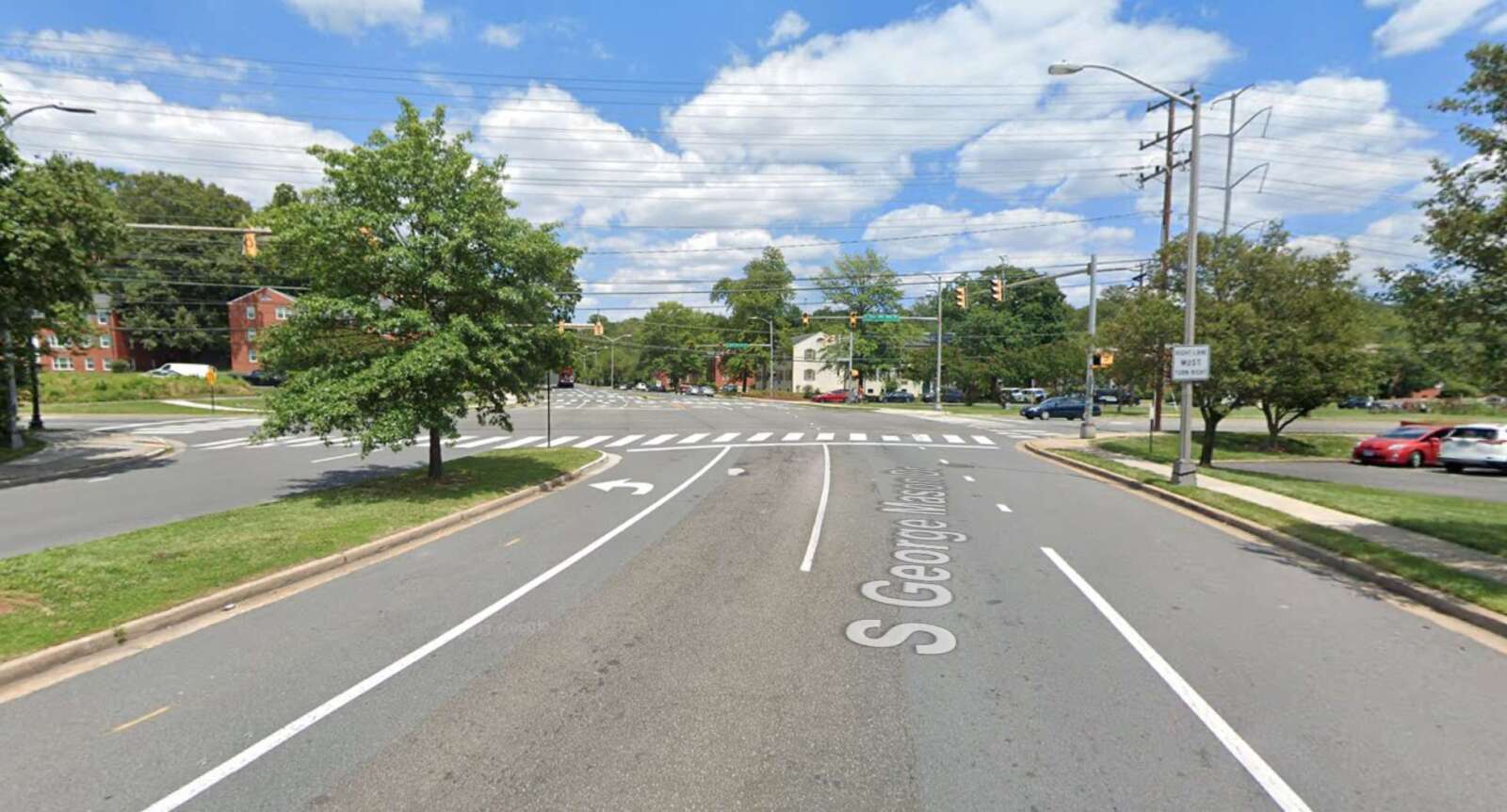
Members of the public can weigh in on proposed improvements to a stretch of S. George Mason Drive that’s being studied.

The road renovation project from Arlington Blvd to the Fairfax County border is part of the South George Mason Drive Multimodal Transportation Study, which aims to “identify improvements” along this “key corridor,” according to the project’s website.

Residents can provide online feedback on proposed design concepts through Sunday, Aug. 7.

The stretch of the roadway being studied is divided into three segments:

  • between Arlington Blvd and Columbia Pike
  • between Columbia Pike and S. Four Mile Run Drive
  • between S. Four Mile Run Drive and the Fairfax County border
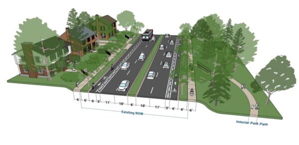
A plan showing the first design concept for the three road segments (via Arlington County)

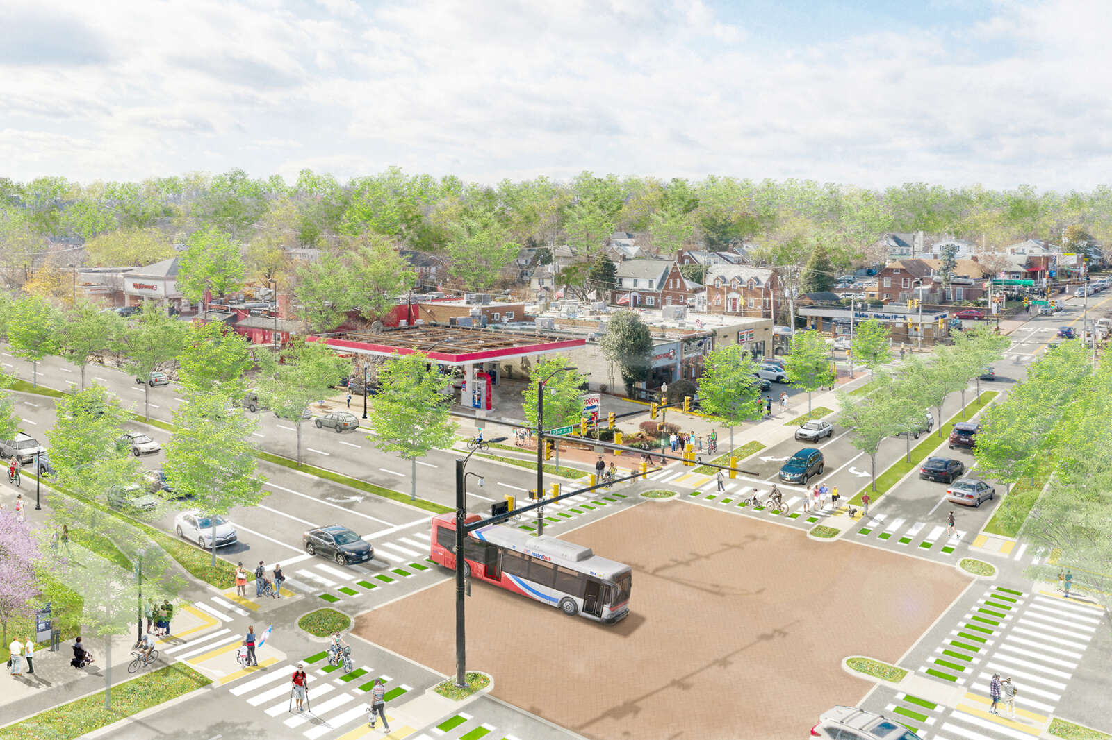
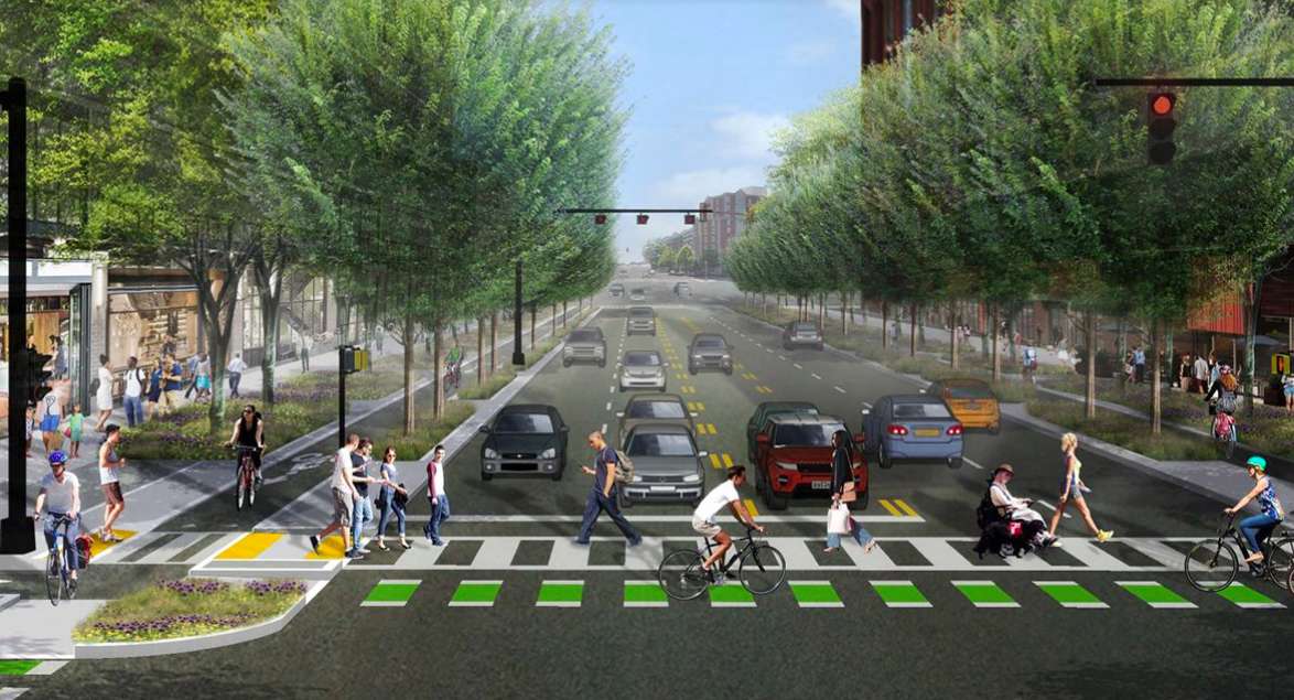
Earlier this month, the county’s Dept. of Environmental Services released its preliminary designs for the three road segments. The first option for all three segments would separate cyclists and cars into different lanes on both sides of the road, and widen the sidewalks and the vegetation buffers on both sides to six feet, according to the concept plans.

However, this design would increase the number of lanes pedestrians have to cross, as well as remove sections of on-street parking and require additional right-of-way behind the curb. Buses would also have to enter the bike lane to pick up passengers, instead of pulling up to the curb, according to an online community meeting.
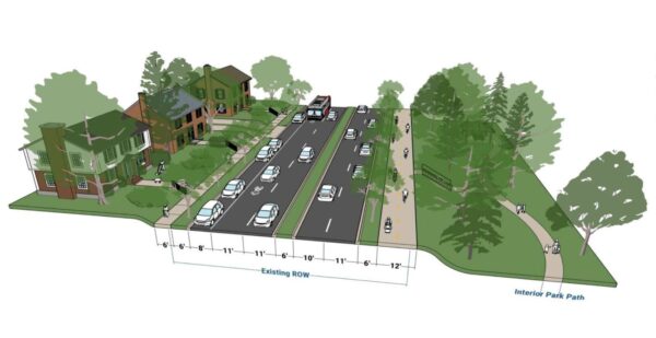
A plan showing the second design concept for the first road segment between Arlington Blvd and Columbia Pike (via Arlington County)

The second option for the segment from Arlington Boulevard to Columbia Pike would widen the west side sidewalk to a 12-foot, multi-use trail and the east sidewalk to six feet. It would also narrow the driving lanes while keeping the parking lane on the east side. The new multi-use trail would connect several county parks, such as Alcova Heights Park and trails like the Arlington Boulevard Trail.

However, this design would remove parking on the west side and require signal phasing changes to reduce conflict with people on the multi-use trail.
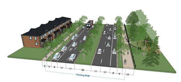
A plan showing the second design concept for the second road segment between Columbia Pike and S. Four Mile Run Drive (via Arlington County)

The second design option for the segment from Columbia Pike to S. Four Mile Run Drive would be largely similar except it would keep the two parking lanes on both sides of the road.
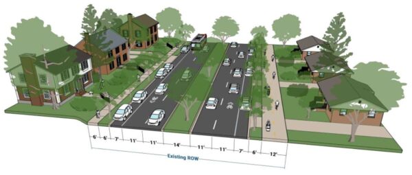
A plan showing the second design concept for the third road segment between S. Four Mile Run Drive and the Fairfax County border (via Arlington County)

The second design plan for the third road segment would narrow all the driving lanes between S. Four Mile Run and the Fairfax County border to 11 feet and the central median to 14 feet, but it would widen the vegetation buffers on both sides and the sidewalk on the west side to a 12-foot, multi-use trail.

However, this plan may result in tree removal due to narrowing the central median, as well as the removal of some parking spots at intersections and driveways. The county would need to consider more design details, such as how the new road would interact with the driveways of houses along the road segment.

The corridor study is set to conclude between October and November this year. The county then plans to apply for grant funding from the Northern Virginia Transportation Authority.

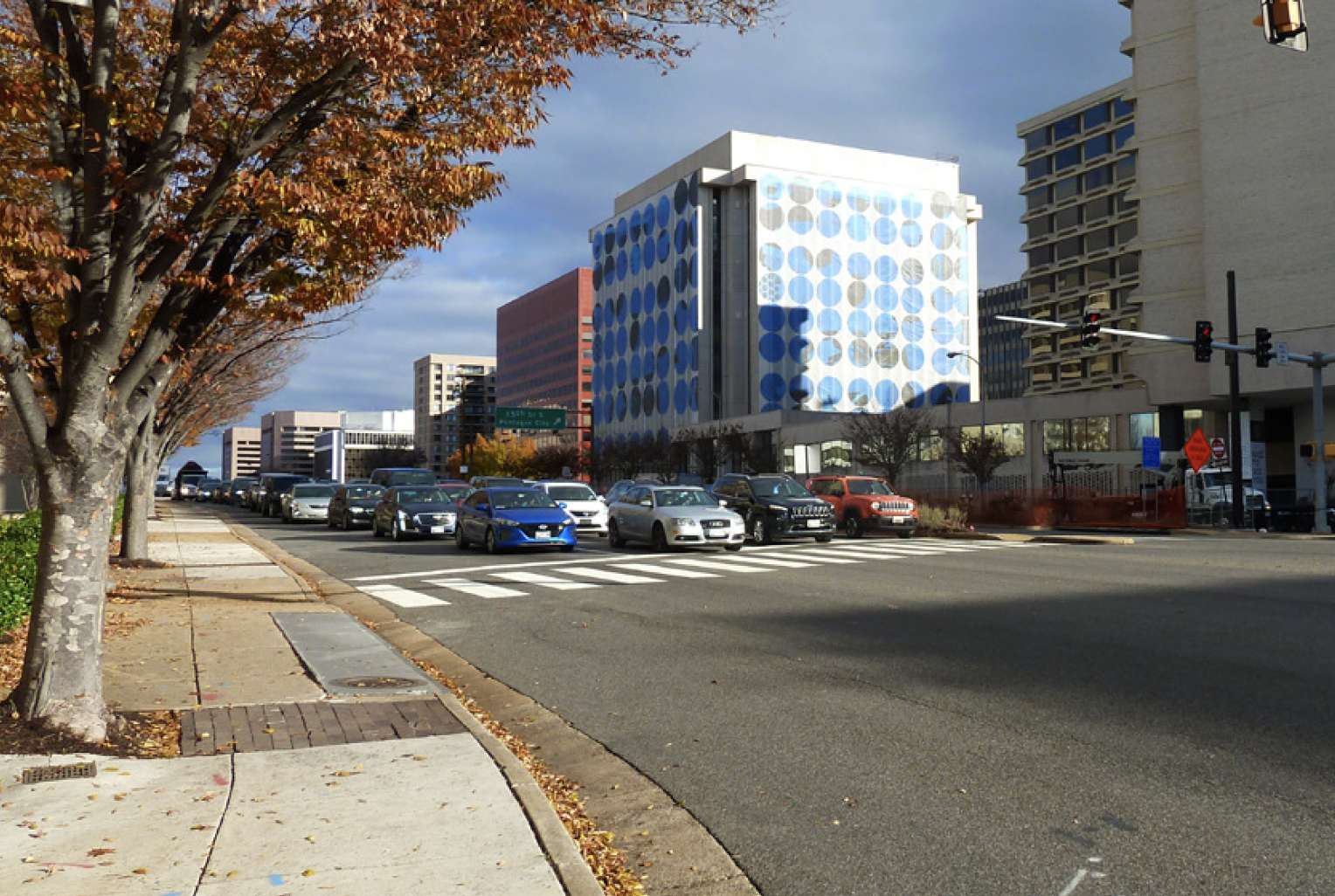
Photos via Google Maps


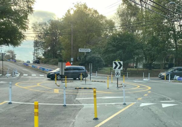
A temporary roundabout on Military Road (staff photo)

A temporary roundabout along Military Road has garnered strong feelings as a deadline for community feedback nears.

The pilot project at Military Road and Nelly Custis Drive launched in October, with bollards in place to direct traffic around the center, and has reduced speeds on all approaches, according to data the county recently released. Benefits to pedestrians are less clear, as vehicle rates were varied and there were small sample sizes for pedestrian crossings.

The data collected on the roundabout’s use will be considered, as well as community feedback — which is being collected through this coming Monday, June 6 — when the county decides in October whether to make the roundabout permanent or to configure an intersection with a stop light instead.

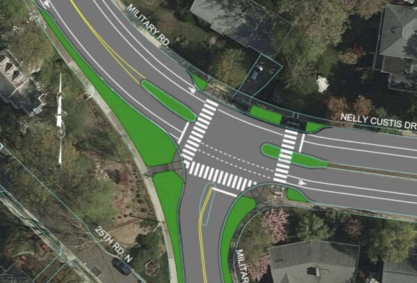
A preliminary mock-up of a signal at the Nelly Custis and Military Road intersection (via Arlington County)

More than 100 comments flooded a Nextdoor post that outlined takeaways from a community meeting last month on the pilot.

“By my observation, all but one or two of the citizens present were opposed to the roundabout at the intersection of Military Road and Nelly Custis Drive,” one user wrote about a recent meeting on the roundabout. “The bottom line is that the County is dead set on ‘re-engineering’ that intersection. Returning the intersection to the way it was for 50+ years was not even contemplated, and it either will have a permanent roundabout or a three-way traffic signal.”

Another resident said “this roundabout is absolutely a solution looking for a problem.”

But other posters — especially those who use the roundabout as pedestrians and cyclists — expressed support, stating that the roundabout “is both more efficient and safer, for cars and for pedestrians.”

The Nelly Custis Drive intersection was identified in the county’s Vision Zero action plan as a location for improvements to increase safety for pedestrians and bicyclists. The roundabout is supposed to increase allow more vehicle traffic, shorten crossing distances for people walking through the intersection, provide predictable turning movements and reduce vehicle speeding.

“Our focus is meeting the project goals of increasing safe, accessible travel for people walking, biking, driving and taking transit through this intersection,” Department of Environmental Services spokeswoman Claudia Pors said.

The Old Glebe Civic Association, which is located well to the north of the roundabout but along the commuter route of Military Road, has long fought against the pilot, saying the changes were unwarranted and there were no significant safety concerns at the intersection.

“Detractors contend that the new pattern has generated confusion and near-accidents, that it is difficult to navigate, and that the required merging of auto and cyclist traffic is particularly dangerous and difficult for cyclists… OGCA pledges continued opposition to the roundabout,” the association wrote in an April newsletter.

Prior to the pilot, Nelly Custis Drive met Military Road at the intersection in a T-shape, with a stop sign for traffic on northbound Military Road.

The OGCA previously said three crashes occurred over eight years, including two involving bicycles, out of the approximately 32 million vehicles that passed through the intersection during that period.

Per Arlington’s Dept. of Environmental Services data, about 11,000 vehicles pass through the intersection daily. In a presentation last summer, county staff said conversions to roundabouts reduce pedestrian crashes by 27%, while conversions from stop-controlled intersections reduce injury crashes by 82%.

(more…)


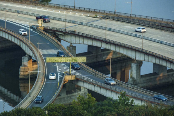
Traffic on the Theodore Roosevelt Bridge at the exits for Route 50 and the GW Parkway in 2021 (staff photo by Jay Westcott)

(Updated on 6/2) Wider sidewalks may be coming to a major Potomac River crossing.

The long-awaited rehabbing of the Theodore Roosevelt Bridge, one of the main thoroughfares connecting Arlington to D.C., will result in a new paint job, updated overhead lights, and significant widening of sidewalks, a new D.C. Department of Transportation report says.

Later this week, the National Capital Planning Commission will meet to approve a new report that focuses on much-needed repairs and rehabilitation of 58-year-old bridge that carries I-66 traffic over the river.

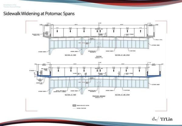
Plan for expanded sidewalks on the Roosevelt Bridge (via National Capital Planning Commission)

The report calls for the bridge to be repainted to its original white color, as well as for updating the overhead lighting and doubling the sidewalk width for pedestrians on both sides of the bridge. It notes that the current sidewalk widths, varying between four and six feet, “do not meet safety standards.”

Neither do the current barriers separating pedestrians from traffic, which are steel columns that are only a few feet high.

“The existing traffic barriers between the sidewalk and traffic lanes provide minimal protection from pedestrians and do not meet current safety standards,” says the report.

While the bridge is owned, operated, and maintained by DDOT, Arlington County has a significant stake in this rehab project considering that it’s one of the main connectors to D.C.

“TR Bridge has been a subject of discussion between our staff and DDOT for over a decade. Arlington has always strongly advocated for improving pedestrian and bicycle facilities on the TR Bridge,” Arlington County Director of Transportation Dennis Leach told ARLnow. “The existing conditions, both on the north side and south side, are pretty meager and really not up to current standards.”

There are also “long term goals” to further connect the sidewalks to more pedestrian-friendly thoroughfares.

On the north side, the walkway connects the Mount Vernon trail in Rosslyn to the Kennedy Center Reach ramp. However, on the south side, the sidewalk currently does not connect to any trail or pedestrian-accessible walkway. Leach acknowledges that taking the south side walkway from D.C. to Rosslyn the entire way currently ends in a dangerous place.

You end up in the middle of the ramp system between Arlington Boulevard, Route 50, 110, and the Parkway,” he says.

The National Park Service, Arlington County, and the Virginia Department of Transportation are working together to look into the possibility of connecting the south side of the Roosevelt Bridge sidewalk to the Marine Corps War Memorial near Rosslyn, Leach notes.

He also brought up that beyond day-to-day traffic, the Roosevelt Bridge is a particularly important connection between Rosslyn and the National Mall, be it for emergency response or for special events like the Fourth of July. The entire bridge length is about 3,200 feet or about .7 miles, so it is short enough to walk and bike across.

“Currently, the sidewalk infrastructure is insufficient to provide good, safe connections between the National Mall and Rosslyn,” Leach says.

Despite it being unsafe, DDOT tells ARLnow that they are “not aware”of any pedestrian-related incidents or accidents within the bridge sidewalk.

In terms of repainting work that also will be done, that has more to do with “a cohesive aesthetic” than safety.

“Staff recommends that the Commission note that DDOT would repaint all structural steel on the Theodore Roosevelt Bridge to match its original white color designed to create a cohesive aesthetic between the bridge and nearby monuments and the Arlington Memorial Bridge,” reads the report.

Work isn’t expected to start for awhile, though. The project’s final design phase won’t completed for another year, a DDOT spokesperson writes to ARLnow in an email, until early summer 2023.  At this point, it’s anticipated that construction will begin at the end of 2023 or early 2024 and will take four to five years to complete, the spokesperson said.

However, the sidewalk widening will be among the first elements of the project to be completed and could happen by the end of 2024.

Currently, DDOT is in the midst of “emergency repairs” that has shut down three lanes of traffic through at least June.

Nonetheless, Leach is confident that when the project does happen, the widening of sidewalks and adding better barriers separating pedestrians from traffic on the Roosevelt Bridge will make Arlington a more pedestrian-friendly place.

“We’ve talked about this project for over a decade,” he says. “These long term collaborations actually yield results. And I think this bridge rehab will bring a really good result for the District, Arlington and the region.”


Members of Congress from Virginia are pushing the federal government to help fund proposed changes to Route 1.

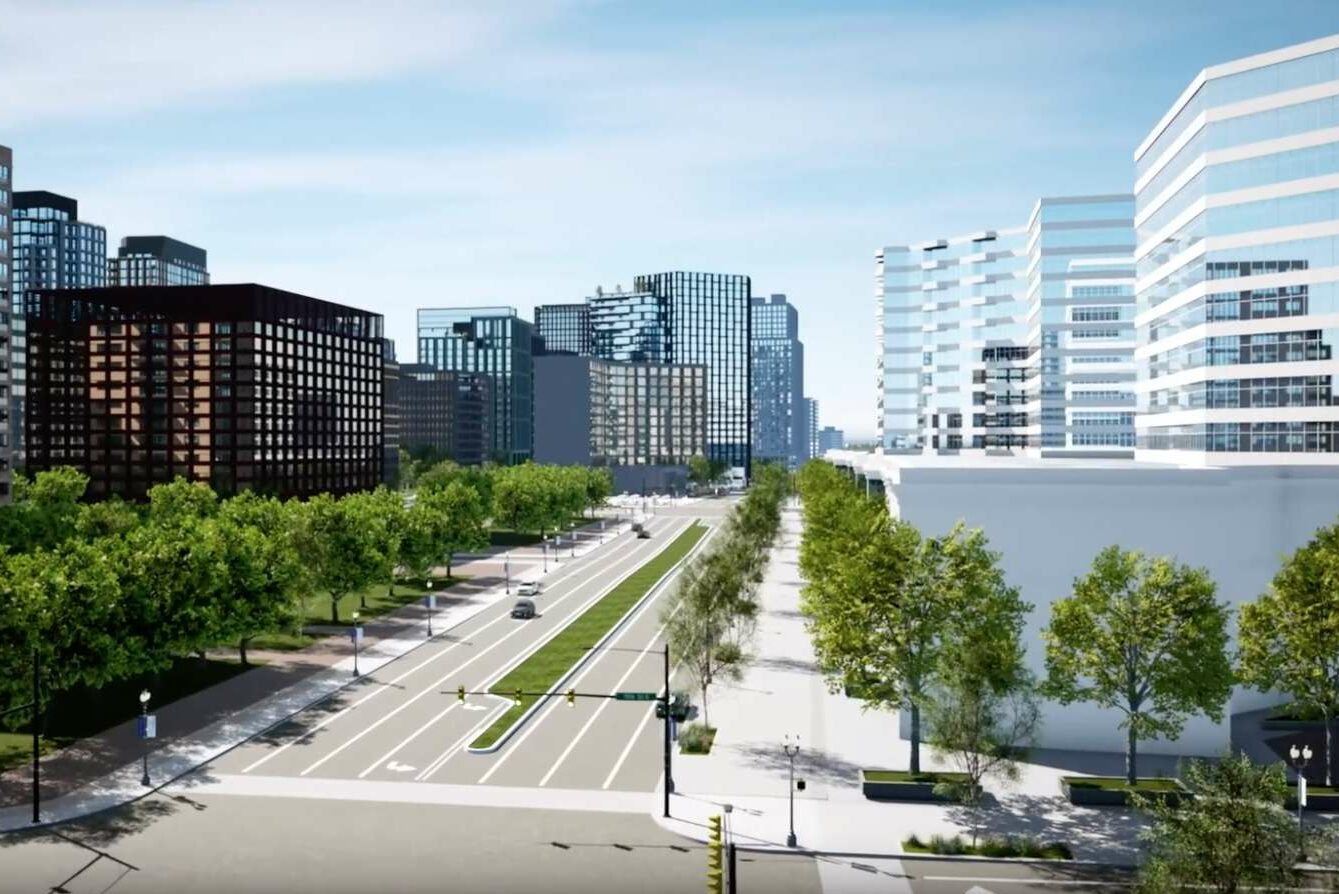
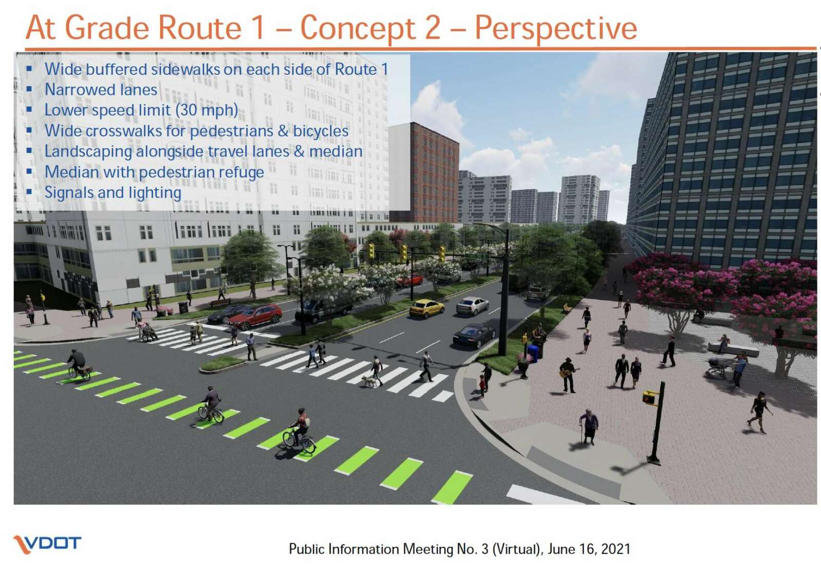
The changes, while still being hashed out by VDOT and local officials, would lower elevated portions of Route 1 through Crystal City to grade, turning it into a lower-speed “urban boulevard.” VDOT is also mulling at least one pedestrian bridge or tunnel at 18th Street S., near the Metro station, to improve safety.

With the first phase of Amazon’s HQ2 on track to open in Pentagon City in 2023, state and local officials see a need to turn the area — collectively known as National Landing — into a more cohesive downtown and economic center. Key to that vision is revamping Route 1, also known as Richmond Highway, which effectively separates Pentagon City from Crystal City.

At last check, cost estimates for the project were around $200 million.

Northern Virginia’s congressional delegation would like to see the feds foot much of the bill, through funding from the 2021 bipartisan infrastructure bill.

In a joint letter to Secretary of Transportation Pete Buttigieg, the lawmakers say argue that the Route 1 project meets all criteria for funding through the infrastructure bill.

“This grant request will allow Virginia to convert the Route 1 corridor in Arlington into a multimodal urban boulevard that prioritizes pedestrian safety in a walkable environment,” the wrote. “VDOT is developing multimodal solutions for Route 1 to meet National Landing’s transportation needs with the coming of Amazon and other related developments.”

The letter was signed by Sens. Tim Kaine (D-Va.) and Mark Warner (D-Va.), along with Reps. Don Beyer (D-Va.), Abigail Spanberger (D-Va.), Donald McEachin (D-Va.), Elaine Luria (D-Va.), and Robert Wittman (R-Va.).

“The Commonwealth’s commitment to Amazon is to improve safety, accessibility, and the pedestrian experience crossing Route 1,” the lawmakers wrote. “Investment in National Landing will produce significant, measurable benefits to the economy, health, and safety of local citizens… This project satisfies all the merit criteria outlined in the federal grant opportunity, especially the priorities of providing economic, state of good repair, environmental, and equity benefits.

The letter also argues for the project’s fiscal benefits, including reducing bridge maintenance costs and providing acres of additional land for development.

“The transformation of Route 1 to an urban boulevard includes the removal of three bridge structures from the VDOT inventory, which will reduce long term maintenance costs,” the letter said. “Modifications to the I-395 interchange will remove a structurally deficient bridge and avoid future replacement or rehabilitation costs, while also extending the urban boulevard to the north which will contribute to lower speeds.”

“[The project] increases the accessibility to job centers through the proposed access improvements, which will benefit residents of all income levels,” the letter continues. “The project will create approximately 6.5 acres of excess right-of-way resulting in high value developable land.”

Another hoped-for benefit: fewer cars and better safety features.

“It will reduce the need for single-occupancy vehicle trips in favor of environmentally friendly options such as enhanced transit service, walkability, biking routes,” said the letter. “The project also includes multiple innovative solutions, such as a progressive design-build strategy and a pilot safety project to implement near-miss crash technology in National Landing.”

The completion of VDOT’s Phase 2 study of the proposed changes is currently expected to wrap up in early 2023. While the project has general support from the county and the business community, some residents have expressed concerns about whether taking away overpasses in favor of at-grade crossings actually makes things more dangerous for pedestrians.

Much of the congressional delegation, led by Kaine, also wrote a letter to Buttigieg supporting funding for an I-64 connector to ease congestion between Richmond and Hampton Roads.


Arlington County staff present the details of County Manager Mark Schwartz’s $3.9 billion CIP for 2023-32 (via Arlington County)

From a new Columbia Pike library to a dedicated pickleball court, County Manager Mark Schwartz’s proposed 10-year $3.9 billion capital improvement plan would fund projects across Arlington.

The first 10-year plan for capital projects in four years would budget for infrastructure projects between 2023 and 2032. The CIP proposal, slated for adoption in July, is a 40% increase from the plan approved four years ago, Schwartz said in his presentation to the County Board Tuesday.

“This CIP proposal aims to address current and future capital needs in Arlington County as we emerge from the financial setbacks caused by the COVID-19 pandemic,” Schwartz said in a statement. “We want to focus on key planned investments in addition to following through on commitments from prior plans to benefit county residents and businesses long-term.”

Stormwater projects would receive $331.3 million in funding, including $77 million for Spout Run, $14.7 million for Torreyson Run, $28.5 million for Crossman Run and $49.5 million for Lubber Run — all flood mitigation efforts. Streams and water quality funding is proposed at $52.1 million and maintenance at $50.2 million.

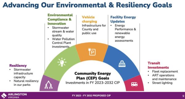
A slideshow outlining what Arlington’s investment in environmental goals looks like in the 2023-32 CIP (via Arlington County)

While Metro remains one of the largest investments in the CIP, at $356.4 million, the proposal also outlines $1.8 billion in non-Metro transportation funding. This includes $16 million for Vision Zero street safety improvements program, $64 million for bridge replacements and renovations, and $89 million for bike and walk programs.

Other highlights include:

The proposed CIP includes new park programs that focus on emerging needs and natural resiliency, a new fire station on the west end of Columbia Pike, and facilities consolidation to enable remote work for county staff.

Schwartz said the needs of the county have changed since the last 10-year CIP, as the county is in “a world shaped by the pandemic where we do our business differently.”

Michelle Cowan, deputy county manager overseeing the Department of Management and Finance, noted during the presentation that the finance department works entirely remotely now, potentially a harbinger of a money-saving reduction in the county’s office footprint.

“We have reduced our footprint which… allows us then to do some really strategic consolidations that you’ll hear about in other county buildings that could get us out of some aging assets,” Cowan said.

The CIP will continue to fund debt service obligations for the investment in housing at Barcroft Apartments, construction of Fire Station 8, which is scheduled to be completed in fall 2023, and the design and planning process for the proposed Arlington boathouse.

Preliminary construction funding for the lower boathouse site is included in the later years of the CIP.

This CIP returns funding levels for the Arlington Neighborhoods Program, formerly the Neighborhood Conservation Program, which are projects identified by individual neighborhoods and include street improvements, streetlights, parks, beautification and sidewalks. The program had steep cuts in previous CIPs.

The 2023-32 CIP proposal would provide $85.2 million in funding to the program. That includes $4 million of funding for projects in fiscal years 2023 and 2024, and would increase to $9 million in 2030 and 2031, Director of Management and Finance Maria Meredith said.

(more…)


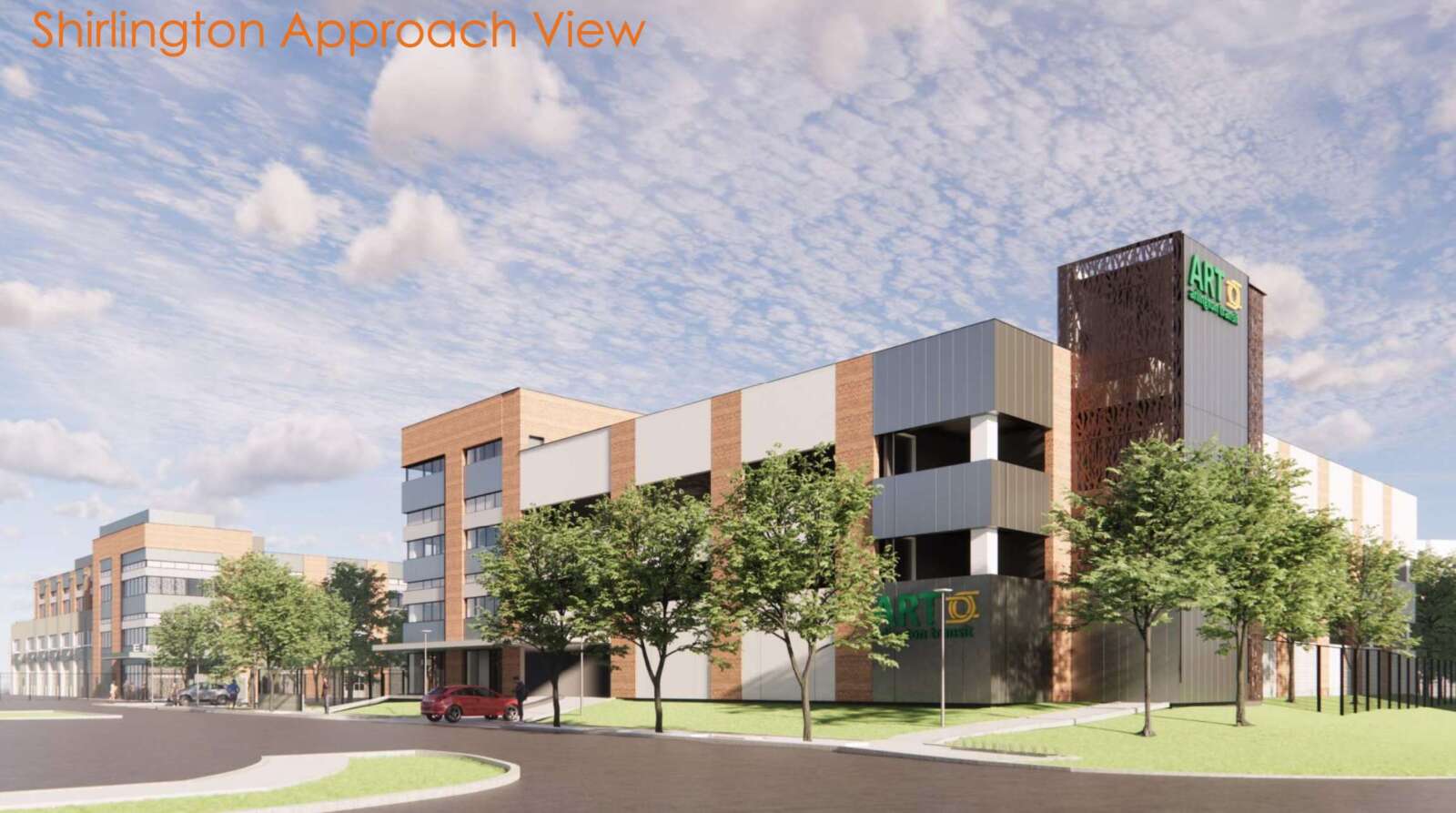
Several items before the County Board on Saturday would tee up an Arlington Transit bus facility construction in Green Valley — to the chagrin of two communities.

The Board will consider approving the use of the new bus facility for commercial parking, temporarily relocating about 30 ART buses to a Virginia Square site during construction, revising a lease to accommodate the temporary storage, and making contract amendments.

Construction on the project off Shirlington Road, which is budgeted at $97 million, is set to start in late spring, per a board report.

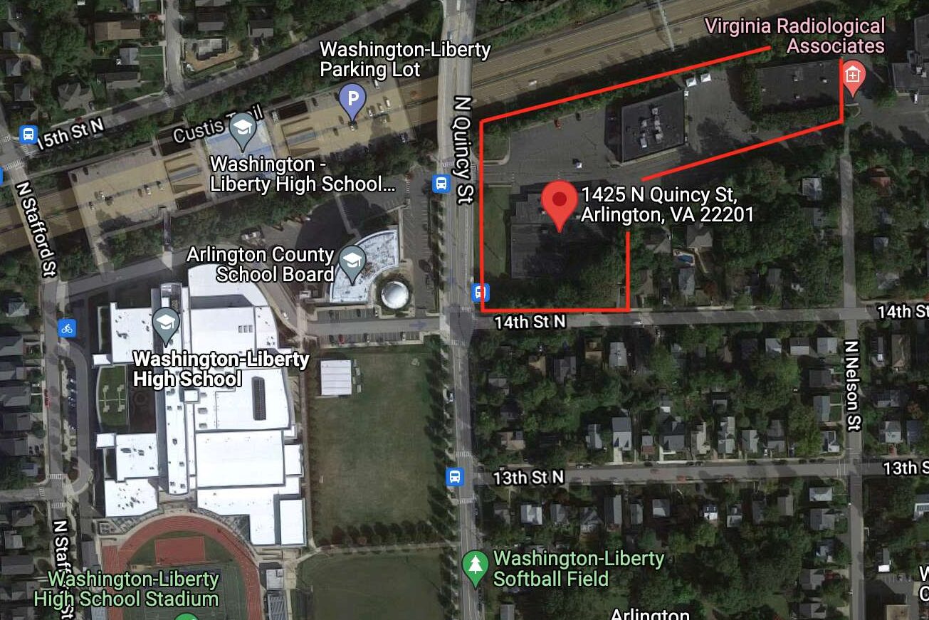
The Ballston-Virginia Square Civic Association is concerned with the county’s plans to use the approximately 6-acre “Buck site” along N. Quincy Street for temporary bus storage. The association claims the property isn’t zoned as a bus dispatch and storage site, and it would be disruptive to the neighborhood.

County officials said in December that property is the only available and affordable site zoned for vehicle storage. Ahead of construction, 29 buses will go to the N. Quincy Street site, while 12 will move to a bus site on S. Eads Street, which opened in 2017 near Crystal City.

“Other sites were considered, both County-owned and private facilities, but these did not meet all the suitability criteria needed to maintain service delivery to our transit riders,” county spokeswoman Jessica Baxter said in a statement. “If the Board approves the application for the use permit, the County has committed to being a good neighbor to minimize impacts to the largest extent possible and be responsive to concerns that may arise from this temporary use.”

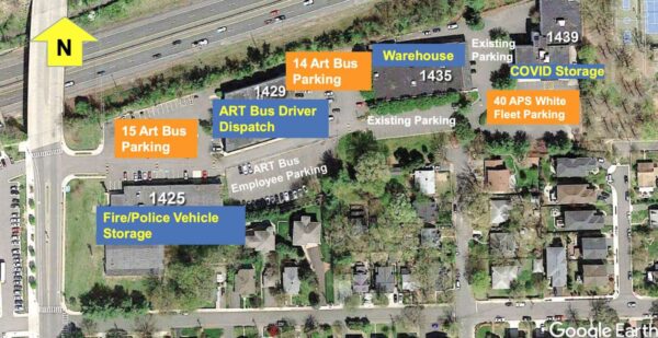
Layout of the county-owned 1425 N. Quincy Street site with the temporary Arlington Transit (ART) bus storage (via Arlington County)

Currently, the county uses the site across from Washington-Liberty High School to park some fire and police vehicles, as well as a portion of the Arlington Public Schools vehicle fleet. An item before the Board this weekend would amend its lease with the School Board to move those vehicles to another part of the site.

The local civic association, however, is opposed to the plan.

“Our neighborhood — like any other in Arlington — should shoulder its fair share of uses that benefit the broader community, even if that sometimes means greater noise, traffic, and pollution,” BVSCA President James Rosen said in a statement. “But placing buses on the Quincy site fails to meet the standard for a good — let alone lawful — use of land the County paid over $30 million to acquire in 2017, of which the County has since written off $5 million.”

Before the county purchased the property, which is zoned for light industrial uses, it was home to family establishments like Jumping Joeys and Dynamic Gymnastics. The county, facing a shortage of land for school and government operations, saw the purchase as a possible school bus facility, which the surrounding community also opposed at the time.

“The noxious effects of the operation of ART buses… will not only put our health and safety at risk, but will compromise the livability of our neighborhood, and put our students and visitors in dangerous situations,” Rosen said.

Arlington’s Department of Environmental Services previously said the peak times of the high school and bus dispatches aren’t the same so it doesn’t think that student safety will be an issue.

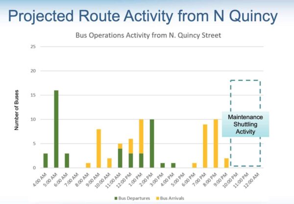
Projected route activity for the temporary bus facility on N. Quincy Street (via Arlington County)

Through 2025, buses will be parked at and dispatched from the N. Quincy Street site on weekdays, with a majority of movement happening between 4 a.m. and 9 p.m., according to the board report. The buses parked on the site would serve six ART bus routes, mostly in north Arlington.

Maintenance and refueling activities would not occur on-site but buses may leave to be maintenanced at other county facilities on weekends.

Green Valley facility

As ART has increased its routes and hours of service over the last decade, and anticipates continuing to increase service over the next 20 years, the operations and maintenance facility in Green Valley is needed, according to a board report.

(more…)


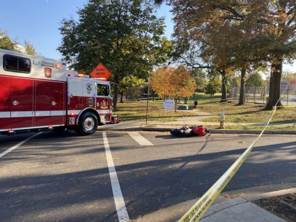
Scene of a fatal crash involving a school bus and a motorcyclist in Green Valley (staff photo by Matt Blitz)

Four people died in crashes in Arlington during 2021, the first year of the county’s initiative to eliminate traffic fatalities and injuries.

That’s in addition to 61 severe crashes, according to the first annual report evaluating the transportation safety initiative Vision Zero.

Arlington County is measuring the effectiveness of its five-year action plan by tracking the severity of crashes and factors involved, such as speed, alcohol and whether a pedestrian or bicyclist were injured.

This month marks the kickoff of the initiative’s second year, which will feature awareness campaigns around behaviors that lead to serious crashes. The campaign will run through December and concentrate on different behaviors each month, starting with bike awareness.

The overall number of crashes in 2021 — 1,785 — decreased by about 30% compared to previous years, but that was attributable to lower traffic levels compared to pre-pandemic years, according to the report.

All four fatal crashes occurred at intersections, and did not involve a pedestrian or bicyclist. In 2020, there were four fatal crashes and 50 that caused severe injury, according to the county’s crash analysis dashboard.

The report noted the 174 alcohol-related and 487 speed-related crashes in 2021 marked a slight uptick. Speed was a factor in one of the fatal crashes.

Lessons learned

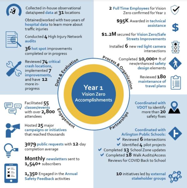
Many of the more than 90 action items the county lists in the framework have been checked off. Arlington has completed or started 36 small-scale safety projects, finished an analysis of 69 crash hot spots, and facilitated 55 transportation safety classes and events, among other tasks.

A graphic shows some of the county’s accomplishments in the first year of the Vision Zero plan (via Arlington County)

Some of the lessons learned in year one include a need to amp up community engagement, and decrease the frequency of crash hot spot analyses from once a year to every two years.

Two walkability routes that were piloted saw opposite outcomes. A pilot on Lorcom Lane in residential North Arlington was extended and county staff are looking to fund a permanent sidewalk there in the upcoming Capital Improvement Plan.

The report noted the Lorcom Lane path “showed high usage, positive community feedback, and observed benefits from separating cars, bikes, and pedestrians.”

But the county halted a similar effort — temporary bollards and wheel stops on S. Carlin Springs Road — months after placement. Arlington Public Schools, Arlington police and community members raised concerns with the pilot after observing “erratic driving around the barriers.”

That area of S. Carlin Springs Road has narrow sidewalks, little or no pedestrian buffer and a history of crashes. The goal of the pilot was to create a safer walking path for students at Campbell Elementary School, Carlin Springs Elementary School and Kenmore Middle School.

County staff will continue to assess options for “enhancing sidewalks and access along the corridor, including connectivity options when the County redevelops the Virginia Hospital Center site,” according to the report.

Several other efforts to increase safety, particularly around schools, advanced in the first year of Vision Zero. The installation of 20 mph school slow zones around 13 schools in early 2022 is under evaluation and could be extended to all schools in the county.

In January, the County Board approved speed cameras in school and work zones, heralding them as a step toward the Vision Zero goal.

In the upcoming year, the report says, there are two full-time employees confirmed to work on Vision Zero and some studies will be completed, such as the evaluation of roadways that have speed limits above 30 mph.


VDOT is not turning back on its recommendation to lower the elevated parts of Route 1 in Crystal City, but it is considering new options for separated pedestrian and bike crossings near the Metro station.

The state transportation agency on Thursday provided an update on Phase 2 of its study, which is focused on how to make the “urban boulevard” vision for Route 1 from 12th Street S. to 23rd Street S. a reality.

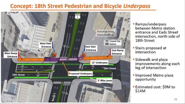
VDOT unveiled concepts for alternatives to a street-level pedestrian crossing at 18th Street after its recommendation to lower elevated portions of Route 1 drew ire from the community for prioritizing cars over pedestrians.

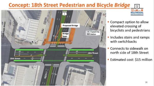
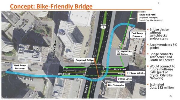
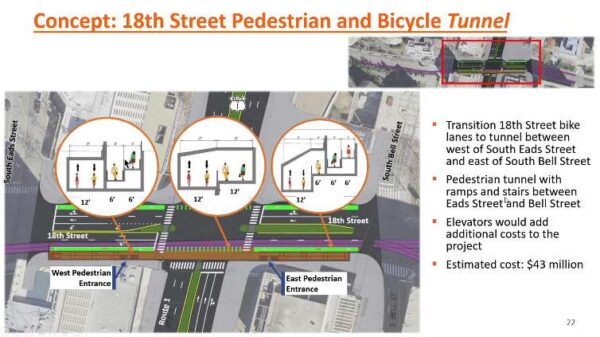
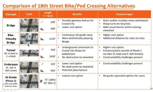
Four alternatives to the at-grade pedestrian crosswalks at 18th Street S. were presented, including a pedestrian bridge; a more gradual, bicycle-friendly bridge; a tunnel; or an underpass.

While the options incorporate some public feedback, including the tunnel proposed by community group Livability 22202, the state is focused on finding a way to make the at-grade roadway work.

“Everything that happens in the Phase 2 study is really looking from that lens of having made that recommendation already and Phase 2 is really geared towards figuring out the details of how to make that recommendation from Phase 1 work,” said Dan Reinhard, VDOT’s lead project manager for the project.

The first phase of VDOT’s study recommended the elevated portions over 12th, 15th and 18th streets be lowered and Phase 2 examines the feasibility of doing that, what traffic in the area looks like and strategies to reduce vehicular traffic.

A table shows benefits and disadvantages to each of the pedestrian and cyclist options for the Route 1 and 23rd Street S. intersection (via VDOT)

The first alternative to at-grade crossings is a 12-foot-wide pedestrian bridge with stairs and an elevator option. VDOT estimates this would cost $15 million.

The second bridge alternative, at an estimated $32 million, would add more gradual entry points for cyclists on 18th Street S. This option could link with a multimodal trail that the county plans to build near the Crystal City Metro station, said John Martin, with engineering consulting firm Kimley-Horn.

The third concept, a tunnel under Route 1, was informed by Livability 22202, a coalition of the Arlington Ridge, Aurora Highlands, and Crystal City civic associations. The estimated $43 million tunnel would accommodate both bicyclists and pedestrians, connecting them to the Crystal City shops and the Metro.

The final alternative is a 12-foot-wide pedestrian and bicycle underpass. In coordination with building owners of the plaza at the corner of Route 1 and 18th Street S., the tunnel could feature a public space at its east entry. An underpass is estimated to cost between $9 million and $14 million.

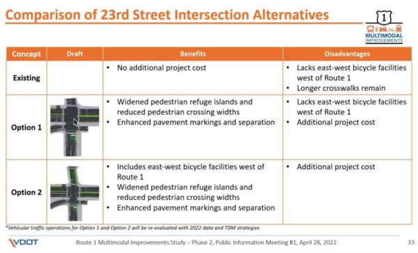
VDOT also presented two options to ease navigation of the sometimes chaotic 23rd Street S. intersection.

At 23rd Street S., VDOT imagines windening pedestrian spaces and medians, removing one southbound left turn lane and allowing through traffic in the northbound right turn lane. A second option would also add bike lanes on the west side of 23rd Street S.

A chart of options for improving the Route 1 intersection with 23rd Street S. (via VDOT)

A second public meeting is expected in mid to late June, which will workshop the curb elements of street design and discuss potential relocation of 18th Street bus stops.

A third will be held in September or October and discuss ways to reduce vehicle volumes through Transportation Demand Management strategies. A final meeting will review the findings and recommendations.


A longtime project to make pedestrian, cycling and transit upgrades to Army Navy Drive has taken the next step forward.

Arlington County has sent the project out for bidding by contractors, while staff continue to acquire the easements needed for construction.

“Project staff expect the easement process to be wrapped up by the time the construction contract appears before the County Board for approval — anticipated later this summer,” Dept. of Environmental Services spokesman Nate Graham said.

Construction could start this fall and be completed in the summer of 2025, according to the project webpage. Initially, the county had expected construction to begin in spring 2020 and be complete this spring, but extra tasks required to receive federal aid dragged out the planning process by a few years.

A coalition of local transit advocates celebrated the news, which has been seven years in the making.

Crashes are a frequent occurrence along Army Navy Drive. The $16.87 million project aims to reduce conflicts among cars, buses, bikes and pedestrians with narrower lanes — to slow down vehicle traffic — as well as bus-only lanes, protected left turns and signalized right turns, clearer sidewalks and shorter crosswalks.

The south side of Army Navy Drive will have a two-way bike lane protected by a line of trees. This will link to a future two-way bicycle lane planned for S. Clark Street, between 12th Street S. and 15th Street S. and the planned protected bike lanes on S. Eads Street, which will run past both phases of Amazon’s HQ2.

Bike lanes on Army Navy Drive are visible in this 2021 rendering of Amazon’s HQ2 Phase 2 campus (via NBBJ/Amazon)

“The project will rebuild Army Navy Drive within the existing right-of-way as a multimodal complete street featuring enhanced bicycle, transit, environmental and pedestrian facilities,” the county says. “The goal of the project is to improve the local connections between the Pentagon and the commercial, residential and retail services in Pentagon City and Crystal City.”

The new Army Navy Drive will be reduced to two through lanes in each direction, narrowing to one lane east of S. Eads Street.

The reduction will accommodate a bus lane between S. Joyce Street and S. Hayes Street so that buses will not block traffic while loading passengers. This dedicated transit lane will help extend an existing network of bus lanes from the City of Alexandria to Crystal City into Pentagon City.

Plans for Army Navy Drive (via Arlington County)

Additional improvements include replacing raised medians with planted ones and planting greenery to reduce stormwater runoff. Five intersections will get new traffic signal equipment.

The project’s early phases kicked off in the summer of 2015 with a traffic analysis evaluating how biking, walking, scooting and driving conditions would be impacted in 2020 and 2040 by the ongoing redevelopment of Pentagon City and Crystal City. That has since been expedited by the ongoing construction of HQ2.


In the next couple of months, Arlington County will launch a campaign encouraging transit use and thanking people who rode Metro and the bus during Covid.

The campaign, aimed at restoring transit ridership rates to pre-pandemic levels, should kick off later this spring or early this summer and will last at least one year, says Department of Environmental Services Director of Transportation Dennis Leach.

“This is an ongoing effort,” he said. “It’s going to take a couple of years to rebuild transit ridership.”

Metrorail use plummeted in March 2020 as large swaths of federal and private employees were directed to work from home. Since then, rail ridership has picked up in fits and starts, most recently recovering by 33% in the fall before the Omicron variant hit. Leach predicts a long recovery for Metro that will depend in large part on federal return-to-work guidelines.

Local bus ridership rates, meanwhile, fell to 50% of pre-Covid rates, as many essential workers continued to take the bus, and had also been recovering quickly before Omicron, he said.

Rates for both modes were ticking up in late February as more people seem to be out and about, as well as commuting to the office, he said. With ridership creeping up and Covid cases remaining low, Arlington County, the Northern Virginia region and the state are all embarking on efforts to further boost public transit use.

Arlington will focus on promoting bus ridership and encouraging Metro trips for accessing entertainment and cultural sites. Targeting Metrorail is paramount, he said, as the lion’s share of Arlington’s pre-pandemic transit riders used Metro, and work-from-home may be around for good.

The county will be seizing on historically high gas prices — fueled by a host of supply issues, most recently the Russian invasion of Ukraine — as a reason to choose public transit.

In Arlington, a gallon of regular gas costs an average of $4.19, up from $2.80 per gallon in 2021 and $3.05 per gallon last month, according to the pump price watch group GasBuddy.

https://twitter.com/GasBuddyGuy/status/1501920976958803969

“Any time gas prices really spike, it’s an opportunity to promote transit as an affordable way to get around,” Leach said. “The ART bus and Metrobus are $2, we offer free transfers from the bus to Metrorail and Metro has introduced a lot of discounts to promote the return to rail.”

Locals can expect to see and hear messages on social media and on Spotify — targeting commuters who listen to music and podcasts — and promotions on buses and in Metro stations.

“Spotify has been helpful in the past for Arlington Transportation Partners to localize where those listeners are and target them where they are,” DES spokeswoman Claudia Pors says. “Hopefully, people are still listening to podcasts on their commute to the living room.”

The local effort is part of a push by the Northern Virginia Transportation Commission to encourage transit ridership. NVTC used a one-time, $500,000 state grant to launch a campaign and asked the jurisdictions in its borders to each contribute to a 20% match, or $100,000.

Arlington is contributing $10,000, which the Arlington County Board approved on Saturday. Other participating localities include Fairfax and Loudoun counties, the cities of Alexandria and Falls Church, and entities such as Virginia Railway Express and OmniRide.

NVTC’s effort and Arlington’s plans dovetail from a statewide transit recovery marketing initiative, for which the Commonwealth has set aside $2 million, and are geared toward an already well-connected region.

“We’re the most transit-centric part of the state — about 70% of state transit ridership is in Northern Virginia,” Leach said. “At the state level, they’re much more focused on commuting. In Arlington, that’s important, but you’re going to see us pivot to transit for lifestyle and using transit to do multiple things.”

Virginians can expect to see the state and region promoting public transit in various news outlets and on social media.

Flickr pool photo by Kevin Wolf


(Updated at 3:45 p.m.) Starting today, locals can zip around the county on new e-scooters outfitted with seats.

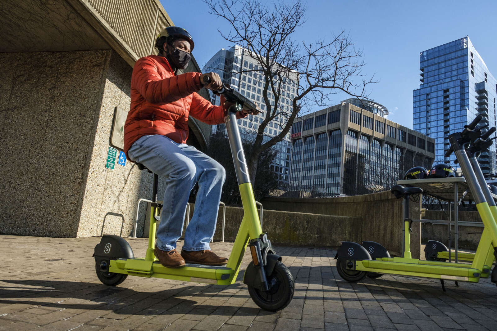
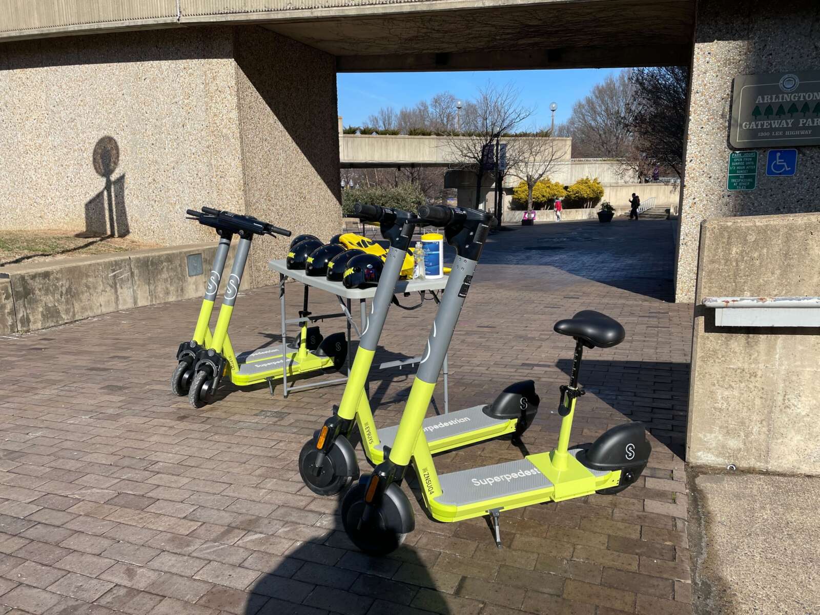
Riders in Arlington will be some of the first to experience transportation company Superpedestrian‘s seated scooters, which look like standing scooters with adjustable bicycle seat — as opposed to the mopeds folks may see around D.C.

“Arlington will be the second U.S. market to receive the Superpedestrian seated scooters, giving a more diverse range of riders a safe, comfortable way to make last-mile trips,” the company said in a statement. The seated scooters made their debut in Baltimore, we’re told.

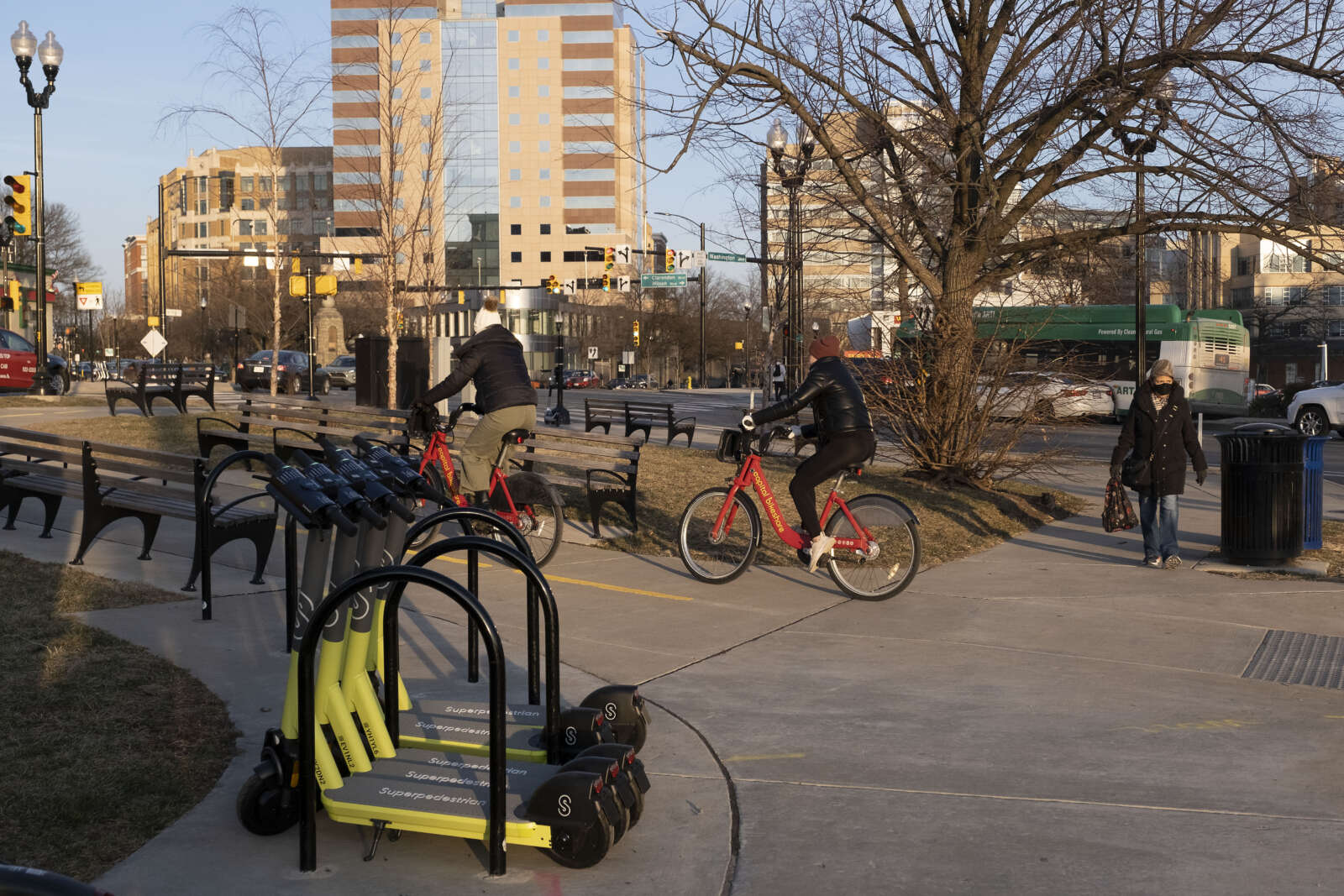
Today (Wednesday), Superpedestrian officially rolled out its shared scooter service, dubbed LINK, in Arlington, introducing 333 bright-yellow and silver standing scooters and 50 seated ones, according to a spokesperson.

LINK also operates in the City of Alexandria and Fairfax County, as Superpedestrian is targeting areas hit by Metro disruptions. These arose after an investigation into a derailment on the Blue Line revealed a wheel defect in the 7000 Series railcars, leading Metro’s oversight agency to have them pulled.

“We’re interested in truly serving this community, by bringing our seated scooter that can allow more riders to use on-demand shared mobility, and by supporting the region through continued Metro disruptions,” said Superpedestrian Policy Manager Cheyanne Woodyard in a statement.

The company says its scooters are safer than competitors’ because they’re the “first and only” ones with on-board artificial intelligence that autonomously performs vehicle safety checks.

It’s also working on technology to improve pedestrian safety, too. Eventually, the scooters will be able to identify and correct unsafe scooting — such as riding on sidewalks — which Arlington has tried to address with signage marking where e-scooters aren’t allowed.

Riders will be charged $1 to unlock a scooter, plus $0.39 a minute. Users scan a QR code on the scooter using the LINK mobile app to begin renting and riding the device.

The news comes five days after Arlington allowed competitor Bird to operate more e-scooters and bikes in the county.

LINK scored second of the five providers allowed to operate in Arlington — which include Spin, Lime and Helbiz — based on a list of county transportation goals, including to promote safety, sustainability and equity.

There is a cap of 2,000 e-scooters and 1,000 e-bikes in the county.

(This story has been updated with the revised size of LINK’s fleet and to correct LINK’s score on the county rankings.) 


View More Stories